Green Line Reconfiguration

Here's what I'm thinking for a Kenmore reconfig that doesn't blow too much shit up:

Current config:
15ez28g.jpg


Future config:
25roz1g.jpg


Red arrows are flow of traffic in the D-to-B direction, blue arrows the flow of traffic in the B-to-D direction. New Lower loop, which is out by the Raleigh St. side, would be double-track but unidirectional. And the inner track on a much shorter length of loop tunnel so the outer one would encase it.

Then decommission the upper loop to free up a little space on the wall side and shave some wall space elsewhere to build an express track bypassing the C/D platforms. UR trains making the BU Central<-->Kenmore<-->Longwood boomerang would stop on the B platforms, skip the D platforms. This, collectively, is what keeps the boomerang moves segregated from fouling Central Subway capacity to/from Hynes.
 
Station spacing. Entrance-to-entrance that well exceeds average subway station spacing in town by a bit. Especially if you're not spitting the back up onto the surface until Pleasant St.

Not at all. The current BU Central and East stations are 460ft apart. One underground station built between both current stations will suffice. The distance between the new station and Kenmore would be about 2,600ft. That's only 500 more feet, as the crow flies, then between Kenmore and Hynes and between Hynes and Copley it's 2,850ft.

I think you might be assuming that BU Central is closer to the BU Bridge but given the clearance you'd need for the junction (one line going to Harvard or GJ and one further down Comm Ave) you are going to have to have the station further east than the bridge.

1. Because that's the operational match for the Urban Ring, which goes all the way across Brookline to Longwood. That one-seat service pattern needs to be part (not all, but part) of the picture for the 66'ers who need to get from Harvard to Longwood and CT2'ers who need to do the same out of Kendall and MIT. That's where the established demand is coming off that quadrant of the Ring. That established demand does not get served without some sort of move that gets you one-seat to the Longwood vicinity.

So... a Harvard spur and a GJ branch of the UR in my plan does literally that. Look at the route of CT2 again. It doesn't go near Kenmore.

2. You gain few to none of the radial relief benefits if everything has to cram back down the Central Subway all the same. The 'boomerang' move between the B and D at Kenmore means this only occupies capacity on the D and this new BU Bridge subway extension, where there is plenty of room to give. Prevailing service patterns can be what you want them to be, but there has to be some diverging routes and short of the impossible cross-Brookline tunnel that's the most innocuous way to do it.

But the issue with capacity isn't at Kenmore, it's between Copley and Boylston. Look at my map again and you'll see what's proposed is a Harvard branch (A) with both Green and UR service. The GJ branch is the only one with no Kenmore service and that's where I question the need for a direct connection when anyone coming in from Cambridgeport can transfer to the A or B trains which area already going downtown. You aren't cramming anyone through the Central Subway when you have two lines going downtown and two going around. That's all the radial relief you need.

If the UR misses Kenmore it's not doing what it's supposed to do. Phase II (the mixed grade separation/mixed street-running BRT plan) does boomerang out at the Kenmore bus station. The stupid Phase III grade separation plan would've removed that for the cross-Brookline boondoggle. Oh, boy...transit loss. BU Central is never ever ever going to be a substitute that stands on its own as Kenmore replacement. It works as the branch transfer where the B splits from the Harvard branch and GJ LRT, but Kenmore's a non-optional destination.

The UR would stop AROUND Kenmore and thus doesn't need to stop IN Kenmore. Think about who is really going through Kenmore Sq, people transferring to a bus or other train to get them further past Kenmore and people going directly to Kenmore (Sox games).

The UR loop hits the major destination just west of Kenmore, BU, and the major destinations just southwest of Kenmore, Fenway and Longwood. Anyone needing to be directly in Kenmore has the option at either the BU Central or Fenway stations to change to a train that will take them directly to Kenmore.

Now sure that isn't perfect but I think it splits the ridership enough where it won't be a huge inconvenience.

Not a total rebuild of Kenmore, either. The west end of the station and the way the branch tunnels split are locked into place. Can't change that. The upper-level loop only goes C/D-to-C/D. Can't change that.

So try dipping down east of the station where the Square is at its widest in a B-to-C/D lower loop that's about as innocuous as the upper-level loop. Pick one set of platforms to stop at on this service pattern; don't stop at the same station twice. Perhaps limit your station reconfig to shaving out the width and shifting around to get a set of passing tracks for whichever platform you skip (D side's probably better for that). And you can abandon the pretty useless upper loop if that's what get you the wall-shaving space for some passing track room.

I see the operations of that going to shit real fast. Also I can see commuters and tourists being completely confused as to which train goes where when some are looping back and some trains are going two different directions on the same platform. Furthermore think of how packed that station already gets and now you add this strange service that requires transfers. Having people transfer back at the BU Central station takes away that issue.

Looking at your map I see more of a solution looking for a problem.


******************************************************************

The gist of the UR plan I have is that it serves more of the Harvard/MIT to Longwood crowd, the ones the UR is really supposed to help. This isn't about giving you unlimited service routing capability. Look at the crosstown bus routes we have now:
- The CT1 goes right down Mass Ave to the Boston Medical Center from Central Sq (Red Line)
- The CT2 goes from Union Sq (Somerville) to Kendall then down to BU via the bridge and loops through Longwood, terminating at Ruggles.
- The CT3 goes from Longwood to the BMC and then on to Andrew.

The UR from my design, using as much existing track (or upgraded ROWs) as possible, follows the combined CT bus routes as closely as possible. None of them go near Kenmore Sq. Kenmore Sq acts as a transfer hub for buses radiating to the west and southwest. The need for a direct UR connection to Kenmore is much lower than you think it is especially when a circuitous UR route picks up much of the traffic that would be going through Kenmore (as opposed to going to Kenmore).

UR service for people goring through Kenmore to downtown won't mean dick since they are already getting where they need to go. UR service just piggybacks the route but serves those who would normally be stuck on the CT buses. The UR doesn't need to go through Kenmore because it's a bypass around Kenmore, a bypass that only helps Kenmore commuters by taking the extra riders off their packed trains.
 
My only question is about the D/E connector at Brigham Circle- would that be an at-grade junction? If so, would it be subject to the same delays as Copley Junction, or would delays be reasonably fewer, as the junction would serve two branches instead of four?

I was trying to draw it but then I remembered I had this amazing visual of how the PATH in Jersey City spits three ways between Hoboken, Manhattan, and JC.

OHR4285.jpg


Keep in mind this is not only under the waterfront of JC but that land is reclaimed from the sea. Doing the same next to the Muddy River is doable.
 
So... a Harvard spur and a GJ branch of the UR in my plan does literally that. Look at the route of CT2 again. It doesn't go near Kenmore.

Your UR tunnel blasts straight through the center of the 12-story BU Life Sciences building and makes carnage of the entire Cummington block. There isn't a single path between St. Mary's St. and Kenmore for making a turn and cutting across that doesn't involve knocking down one or more 6+ story BU buildings (and, remember...high-rise about to go up on the parking lot next to Morse Auditorium). That path doesn't exist. It's either hang far west on the cross-Brookline/I-695 alignment we know doesn't work, or interface with Kenmore somehow.

There are no easy answers here...but any answers are easier than knocking down gigantic recent-construction university high-rises. Can't get there from here.

But the issue with capacity isn't at Kenmore, it's between Copley and Boylston. Look at my map again and you'll see what's proposed is a Harvard branch (A) with both Green and UR service. The GJ branch is the only one with no Kenmore service and that's where I question the need for a direct connection when anyone coming in from Cambridgeport can transfer to the A or B trains which area already going downtown. You aren't cramming anyone through the Central Subway when you have two lines going downtown and two going around. That's all the radial relief you need.
See the utter, complete, total physical impossibility of the path you're proposing above. The tunnel's already out of rope for cutting across Cummington Mall by the time it's bent its way under the Comm Ave./Carlton St. intersection. There's no way to tie it all in to BU Central for one platform you can step-on/step-off to get anywhere. You're frozen on-trajectory to Kenmore by that point. Stop at both or stop at neither, but splitting the difference is physically impossible.

The proposed UR Phase III tunnel was going to go down Amory and Kent Streets to reach Longwood Ave. That means BU West 'Surface' + 'Under' would've been the transfer station, way too far west of the bridge for a platform to be able to catch all diverging traffic.

Doing a Mountfort St./Park Dr. routing instead also requires bailing out well before BU Central. Requires blowing up the pair of 6-story apartment buildings on Park Drive @ Medfield St. for the D merge. Requires god knows what flood mitigation because now you have 2 portals at ground zero for the subway's #1 water intake vulnerability. And the junction is going to push the D merge back far enough that it misses the Fenway station platform and Longwood becomes your backwards transfer inbound. Because otherwise it's move the Fenway platform to the St. Mary's-Monmouth Ct. block where it's barely 1200 ft. from Longwood, has far inferior street access, is now 3200+ ft. from Kenmore, and no longer with direct access to Landmark Center and Fenway Park. I'm guessing that's all a nonstarter, so Longwood is where the transfers have to go.


The UR would stop AROUND Kenmore and thus doesn't need to stop IN Kenmore. Think about who is really going through Kenmore Sq, people transferring to a bus or other train to get them further past Kenmore and people going directly to Kenmore (Sox games).

The UR loop hits the major destination just west of Kenmore, BU, and the major destinations just southwest of Kenmore, Fenway and Longwood. Anyone needing to be directly in Kenmore has the option at either the BU Central or Fenway stations to change to a train that will take them directly to Kenmore.

Now sure that isn't perfect but I think it splits the ridership enough where it won't be a huge inconvenience.
It is if the tunnel flat-out can't hit the transfer stations.

I see the operations of that going to shit real fast. Also I can see commuters and tourists being completely confused as to which train goes where when some are looping back and some trains are going two different directions on the same platform. Furthermore think of how packed that station already gets and now you add this strange service that requires transfers. Having people transfer back at the BU Central station takes away that issue.
Except when they can't transfer at all at BU Central because it's physically impossible.

The gist of the UR plan I have is that it serves more of the Harvard/MIT to Longwood crowd, the ones the UR is really supposed to help. This isn't about giving you unlimited service routing capability. Look at the crosstown bus routes we have now:
- The CT1 goes right down Mass Ave to the Boston Medical Center from Central Sq (Red Line)
- The CT2 goes from Union Sq (Somerville) to Kendall then down to BU via the bridge and loops through Longwood, terminating at Ruggles.
- The CT3 goes from Longwood to the BMC and then on to Andrew.

The UR from my design, using as much existing track (or upgraded ROWs) as possible, follows the combined CT bus routes as closely as possible. None of them go near Kenmore Sq. Kenmore Sq acts as a transfer hub for buses radiating to the west and southwest. The need for a direct UR connection to Kenmore is much lower than you think it is especially when a circuitous UR route picks up much of the traffic that would be going through Kenmore (as opposed to going to Kenmore).

UR service for people goring through Kenmore to downtown won't mean dick since they are already getting where they need to go. UR service just piggybacks the route but serves those who would normally be stuck on the CT buses. The UR doesn't need to go through Kenmore because it's a bypass around Kenmore, a bypass that only helps Kenmore commuters by taking the extra riders off their packed trains.
Note that the ACTUAL Urban Ring Phase II plan hits Yawkey in walking distance to Kenmore.
9a341972-4ead-457e-84de-b4b2b514d34a


The Fenway area's completely cut out of this on the available options. Purple dot goes away and there's no longer an Indigo Line interface for Brighton and Newton with West and Yawkey both missed trajectories. And the two nearest Green dots shift further west. That's a lot of node sacrificies the real studied plan was counting on around here.

You're going to have a hard time going to bat for full grade separation when it drops such large destinations from the surface route. Skips the Fenway neighborhood. Skips BU East Campus. Now BRT's starting to look like the better mode for what it doesn't skip. Which I don't think was the interntion here.


The point of going to Kenmore is not because of hedging on all service options. It's because you can't physically construct a tunnel anywhere else within a mile of here at anything approaching feasible engineering or cost. Cummington Mall is a 1000% no-go. And everything else is I-695 revisited. It's not solution in search of a problem because we know full well what the problem is: any tunnel construction east of the bridge that isn't under the B reservation is D.O.A.
 
We should probably also remember some of the tunneling costs golden rules before Alon reads this and needs to punch a wall.

Pre-prepared areas are always cheaper than creating something out of nothing, where the megaproject costs sail into the stratosphere. The real UR Phase III grade separation is totally bonkers for ignoring that. So where, amongst limited options, is there any easy tunneling?

The B reservation.
-- Kenmore to BU Bridge has hosted continuous electric streetcar service since 1892. There's bare minimal crap underground between grade crossings/cross streets because there was never time to bury crap underground with electric trolleys running for pretty much the entire history Comm Ave. had has running water. We know we can cut-and-cover for that 1 mile framed by the reservation's footprint and not break the bank.

-- We know with a 200 ft. corridor width that we can fit at least 1 intermediate station under the roadway footprint. And that so long as the aesthetic opulence gets clamped down that the construction impacts shouldn't be a bear.

-- We know the only hard spot is the 1000 ft. x 250 ft. area centered over the bridge spanning Carlton St. and Amory St. where there'll be a junction, a B tunnel that has to slip under the Pike and Worcester Line before portaling-up around St. Paul Station, and a diverging split for the UR. We also know that Pike construction nuked everything in this rectangle except for the historic BU MET building and re-landscaped all areas below the level of Comm Ave., so the dig impacts aren't much of a variable...construction costs for the underground junction are.

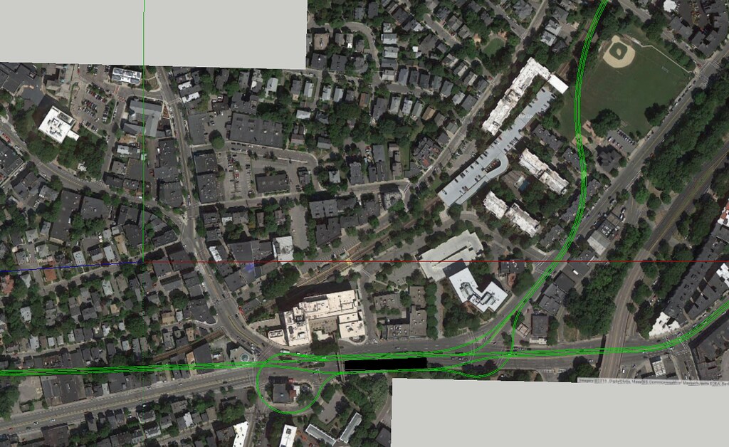
-- We know that the UR portal itself is going to pop out the hillside right here and that everything afterwards (GJ or Harvard spur) is on the surface. With the Harvard ROW traceable and unimpeded on the Campus Master Plan property maps out to the Stadium.

-- We know that at bare minimum...with zero modifications to Kenmore...that service to/from the UR and Harvard can be fed out of the Central Subway to here.

^This^ much we all know with reasonable confidence that we can do if the project is managed responsibly, with no major man vs. geology or man vs. building struggles.


The E reservation.
-- We know the 1 mile from Northeastern incline to Brigham Circle is an under-reservation dig relatively straightforward.

-- The under-street width is there for doing 2-3 rote-standard subway stops, as long as the opulence is kept in check.

^This^ much we know we can do if it's managed responsibly.


Less-favorable. . .

E under-street
-- We know that Brigham to Mission Park is the same tunneling distance as Red-Blue (MP being the furthest known-known point where we're 100% certain to be under Huntington, before Riverway trajectories come into play).

-- We know that street and sidewalk width are adequate: 75 ft. for Huntington, 90 ft. for Cambridge St. where the Red-Blue surgery was only going to close 2 lanes + parking rows at a time on any blocks that were cut open. We know that there are no buildings taller than 4-story brick apartments abutting the street. We know there is bedrock underground, much like there is with Red-Blue.

-- We know that the only plausible spot for a station on this segment (if there needs to be one) is where the Mission Park front lawn serves up 120 ft. of width, which is as wide as Huntington is at Symphony.

^This^ much we know has enough comparisons with well-studied projects of similar tunneling jobs to establish more or less reliable cost and feasibility bounds. And it'll look a lot more favorable if Red-Blue can be built at tolerable cost.


Much less favorable. . .

The question marks. . .

-- The Huntington-to-D interface. We don't yet know enough to even speculate. And several trajectories are viable. We have a rectangular study area, a place spanning the study area where the Emerald Necklace water table is at its slimmest that opens up the proverbial 'mountain pass' of minimal waterproofing, known building impacts, and known building ID's of what's a welcome nuke-and-redevelop (the car shops on Brookline Ave., the NEIA eyesore) and what's to be avoided (apartments).

-- The UR-to-D interface. For just what these last few posts have debated. There isn't an easy answer. Conceptual perfection goes off-scale on cost and impacts, lower-impact isn't conceptually perfect and may have some performance ceilings.

^This^ should keep us up at night, fuel years and years of healthy debate. cause us to choose battles carefully, and have the shortlist of things that can be compromised out while still achieving goals. If we have to deal with pain threshold, then pay attention to those rectangular 'study areas'...how self-contained are they, what are the landmines inside them to avoid, etc. We don't know what the final outcome is going to be, so grade these areas by sprawl of the study area and severity of the impacts within the study area. The "go for it" combination is smallest area of impact with fewest impacts within the area that accomplishes the most goals. Balance the ledgers accordingly.


And then. . .

The boondoggles. . .
-- Plowing across Brookline or BU. Any way it's a >$4B megaproject with disastrous impacts to tall buildings, incredibly difficult EIS'ing in the Muddy River floodplain, and the same exact monied interests that stopped I-695 dead.

-- Going down any 2-lane streets with close-abutting tall buildings. Longwood Ave., Francis St...impossible. Blandford Mall...doubleplus impossible.

No...just, no. A billion dollars per 900 ft. of tunneling is a project concept that's self-immolating. If these are the hangups between doing it at all and not doing it at all...then just don't do it at all.
 
All of this discussion has been fantastic- thank you both. Van, that diagram you posted is super helpful! Much appreciated.
 
My solution, also allows for incorporation of a Kenmore-style bus shelter.

No time to explain, late for work...

16539504113_8343bfdcfb_b.jpg
 
F-Line: Your point about going under the 12 story BU building is correct but that doesn't mean the route is unworkable. Move the route just to the east under Blandford St and it's doable. Yes the street is narrow but not impossible. You just need to dig deep enough to go under the C line tunnel there before you connect to the D. Hell, maybe just rebuild the C/D interchange to fit in the UR and you can avoid even traversing the land slated for the Fenway Center. It's tight but not impossible.
 
I terms of making BV a terminal I love it.

I was thinking that, and it gives you a slingshot for the urban ring. Deep bore under the existing buildings in the west, cut and vocer everything else. I figure the buildings to be demolished in those projects can be rebuilt larger. You also get to redevelop the existing ROW, so the project could could recoup most of its costs
 
davem: Keep in mind modern transportation planners prefer stub end tracks for terminals as opposed to loops. Loops come from when trains only had one drivers seat. The loop can back up quickly while having a couple stub end tracks past the station gives you more operational wiggle room. Your plan will also work better with two platforms, especially if it is to act as a terminal you are going to want to separate the crowds.

I really dislike the slingshot approach and it seems to be a trend in F-Line's designs. While it looks good on paper to simplify all the transfers to one station and one set of platforms it also creates a single point of failure. If a train is derailed at Kenmore or in this case the BV station then it backs up service on 3 different lines. Spreading the transfers out to different stations also lightens the crush. Also part of the point of having a circumferential transit service is to account for when service is stalled on one of the spokes. If a train breaks down along the Central Subway then passengers further out can take the UR to switch to another line to get where they are going.

What we are proposing with the D-E connector is very tricky. Like I said earlier what will most likely get built is just a simple tunnel connection and the loop/terminal at Reservoir upgraded. All these fancy BV alignments are alone because I've proposed adding either a shuttle service to Kenmore or the Urban Ring.

The Urban Ring has always been something that looks good on paper but then gets very complicated when you get down to the details. The point of this thought exercise was to simplify things by using the Green Line but the only way to do that without mucking up the Green Line is to expand the branches through which the UR will run to handle both services. This is why these slingshot loop ideas are dangerous; the plan is already precarious at best and adding these single fault points just makes them more difficult to operate both lines.
 
F-Line: Your point about going under the 12 story BU building is correct but that doesn't mean the route is unworkable. Move the route just to the east under Blandford St and it's doable. Yes the street is narrow but not impossible. You just need to dig deep enough to go under the C line tunnel there before you connect to the D. Hell, maybe just rebuild the C/D interchange to fit in the UR and you can avoid even traversing the land slated for the Fenway Center. It's tight but not impossible.

It is impossible with the building impacts. Tall structures, deep pilings. The mitigation costs sail through the roof. Blandford is ~8-12 ft. narrower than Essex St. on the SL Phase III routing. And we know how many billions of dollars in extra mitigation were required for a width that constrained. Making the right turn anywhere east of St. Mary's is going to add $1-2B extra. Minimum. It will. That is not in any doubt because we went through this already with actual Silver Line engineering and real engineers adjusting the costs.


That isn't practical or responsible tunneling. If mapmakers' perfectionism is that sacred here that it's somehow a must-have...then you're not going to build the project anyway because mapmakers' perfection on some other project is going to jump it several places in priority because there's better bang-for-buck to be had elsewhere. A billion dollars per 900 ft. of tunnel isn't justifiable in any world. Any which way, same result: the routing never comes into existence, you don't get anything done, and we just end up debating a total abstraction.

Try to get something done if this exercise is supposed to net something more useful than pretty lines on a map. Getting something done involves avoiding boondoggle tunneling and sticking to the routes where the impacts are digs under the cleanest possible ground with no impacts to tall structures. If the 'hard' spots have to be justified because there's no other way--like that trajectory off Huntington to the D--then limit the impacts to disposable structures like the 1970's eyesore NEIA building at BV or this one apartment building on a corner for hitting that trajectory across Brookline Ave. Playground. Stuff where the extra pain and suffering has an upper limit at the lowest end of 9 figures. Or just admitting there's going to be less throughput to go around and evaluating if a branching GJ-Central Subway circuit on the under-reservation tunneling straight through to Hynes with no Longwood connectivity, and a Copley Jct. relocation with D traffic partially throttled through the Huntington subway is effective enough at clearing downwind congestion. When the build options are this limited, have some idea in advance how far you're willing to scale back for "good enough" within-cost to accomplish the goal.

Passing that up for perfect lines on a map isn't a real-world solution...it's an abstraction for sake of drawing pretty maps. It doesn't have to be Kenmore, but it can't be east of St. Mary's no way no how (because we know that from the SL Phase III engineering debacle), can't be the UR Phase III/I-695 plan, and can't involve BU Central subway station as a catch-all transfer spot for every diverging route. I don't know what other than Kenmore is possible because a Mountfort/Park Dr. subway has so many problems of its own with the D interface and extremely high flood risk, and there's so few paths to choose from overall that don't incur superfluous $B's to no operational benefit. But I'm willing to listen if it gets the gist of the service done, warts and all, with something eventually buildable in the real world. Blowing up newer-construction BU academic towers isn't buildable in the real world.
 
One of you please explain to me why B<->D is even a necessary move here?

As far as I can tell, connecting (or "connecting" with a transfer station) to the B at BU Bridge isn't in question here.

But if you're putting your transfer point here then I'm struggling to see where the value add is in through-running your trains into the B branch (tying them to B branch schedules in one direction), looping around Kenmore (introducing a loop track), and then running back out of Kenmore on the D branch (tying them to D schedules in the other direction).

Way too much complexity, way too many opportunities for failure. I can't believe that's the best choice for servicing that cross-section of the ring - nor can I believe that if it is, introducing a two-seat ride is going to be such a demand killer that the Kenmore Loop F-Line is proposing ends up a better value-add than reorganizing the Central Subway's schedule to permit running trains between the Grand Junction and the Seaport along whatever east-west route eventually interfaces with the bus tunnel at South Station.

Alternatively, the spaces underneath the Pike and the B&A Main Line are both entirely clean-roomed, are they not? Google suggests that the C/D split happens underneath the intersection here, which easily interfaces with any Pike/Main Line alignment and is 600 feet from the center of the Yawkey platforms. Add another stop for spacing purposes halfway between the C/D split and St. Mary's - call it BU South and build exits out to either side of the Pike. The spacing works, you've added another way for pedestrians to cross the Pike, tunneling under the Pike itself avoids whatever problems could be lurking under Mountfort, and the biggest victims of the construction effort are the people parking at that Yawkey parking lot.

It's not perfect, but I'm guessing it's not going to be dollars-to-miles more expensive than any other tunneling project in this town. The only real blocker I can imagine would be if someone gets the bright idea to bury the Pike - but after what happened the last time we buried a freeway here I'm not sure another highway tunneling project is going to happen at any point in the future. Certainly not before the technology advances to the degree that a preexisting rail tunnel becomes a non-issue.
 
One of you please explain to me why B<->D is even a necessary move here?

UR is proposed to go from Cambridge to Longwood, but when total grade separation (i.e. Phase III) is desired there is no straight line on the map you can use to cut across that wouldn't cost more than the NSRL or Silver Line Phase III. The state's own preferred routing recycles the same paths that were killed 45 years ago with the Inner Belt/I-695 tunnel, so it's not physically possible.

The only alternatives are:

#1. Give up on LRT entirely and concede that this will be BRT-only, and somehow riding on the street all points from BU Bridge to LMA with all the performance and capacity penalties therein.

#2. Do the easy under-reservation B tunneling to St. Paul St. with an underground junction at BU Bridge portaling-out onto the grassy hillside, and run the UR as a Green Line branch or circuit. Reverse-transfer on the Kenmore platform. Then pursue other projects (Copley Jct. relocation, D-to-E load-balancing, etc.) to clear the Central Subway of as much congestion as possible to keep the headways stiff and reliable.

#3. Find some cost-controlled way of slingshotting between B and D to complete the Cambridge-to-LMA link bootstrapped on as much existing infrastructure and easy-dig tunneling as possible, and as much performance optimization as possible. The area of debate is the sliding scale between how much 'hard' tunneling that entails, and what compromises are acceptable while still reliably meeting the service goals.


As far as I can tell, connecting (or "connecting" with a transfer station) to the B at BU Bridge isn't in question here.

But if you're putting your transfer point here then I'm struggling to see where the value add is in through-running your trains into the B branch (tying them to B branch schedules in one direction), looping around Kenmore (introducing a loop track), and then running back out of Kenmore on the D branch (tying them to D schedules in the other direction).
Well, that's the area of debate. It's either. . .

-- Find a path across that doesn't cost a megaproject-and-a-half and wreak destruction on BU and old-money Brookline.

-- Run it as a branch/circuit straight through an unmodified Kenmore and go fishing for Central Subway performance/congestion improvements elsewhere.

-- Bootstrap on the branches to save the megaproject tunneling and recycle infrastructure with capacity to give. And try to keep it so that it doesn't touch the Central Subway mainline track (i.e. one branch's dedicated track berth on the Kenmore islands is the literal tip before branchline becomes mainline)

Way too much complexity, way too many opportunities for failure. I can't believe that's the best choice for servicing that cross-section of the ring - nor can I believe that if it is, introducing a two-seat ride is going to be such a demand killer that the Kenmore Loop F-Line is proposing ends up a better value-add than reorganizing the Central Subway's schedule to permit running trains between the Grand Junction and the Seaport along whatever east-west route eventually interfaces with the bus tunnel at South Station.
Which may be where this ends up. We simply have to concede the UR's goal of serving Longwood on a one-seat. The debate we're having is simply what's salvageable from extremely limited options. Shoot to downtown sans Longwood is the fallback position. And still a worthwhile one if that's all we can do because of the very modest tunnel costs to BU Bridge and the all-surface routing past there. You just have to commit to some serious congestion mitigation downstream like the Copley Jct. relocation. If not simultaneously, then at least a resolution to start the ball rolling so starter service has the extra gears that'll track with growth.

Alternatively, the spaces underneath the Pike and the B&A Main Line are both entirely clean-roomed, are they not? Google suggests that the C/D split happens underneath the intersection here, which easily interfaces with any Pike/Main Line alignment and is 600 feet from the center of the Yawkey platforms. Add another stop for spacing purposes halfway between the C/D split and St. Mary's - call it BU South and build exits out to either side of the Pike. The spacing works, you've added another way for pedestrians to cross the Pike, tunneling under the Pike itself avoids whatever problems could be lurking under Mountfort, and the biggest victims of the construction effort are the people parking at that Yawkey parking lot.
The C/D splits a little further east than that, staying on-alignment at least until it gets on the other side of Overland St. But the bigger issue is that it's much too sharp an angle to approach and rope in from the west on a converging line. That's not going to be possible. You'd have to come from a much more perpendicular N-S angle, which means Van's map's wrecking ball through the Cummington block. There will be something extremely tall on the cursed Fenway Center parcels flanking narrow Maitland St. by the time you build this, so the only way to interface is at a 310-something degree angle by Yawkey Station that may even be tighter than Kenmore Loop.

I doodled with this one too. There just isn't a non- B trajectory to be had east of the disposable Radio Shack/CVS building by the corner of Comm Ave. and St. Mary's (assuming BU doesn't raze it and erect something as tall as the Photonics Center before then). The only other way is going under Park Dr. where 1) the 90-degree interface with the D and probable portal are at the subway system's #1 most flood-prone spot, 2) where the two tallest apartment buildings in the neighborhood have to get razed, and 3) where Fenway station would either have to be moved unacceptably far west to trap UR trains or just be an outright skip. But I bet even if you could square #2 and #3 that the flood risk is still what's going to scare the engineers the most. Charles Dam isn't going to be able to dump the Basin including the Muddy watershed as quickly or thoroughly as it used to in the sea level rise era.
 
Last edited:
Then barring some major redevelopment by BU the idea is a bust.

There is the idea of running the ring through the Central Subway but given how tight the loop (using the GJ) would be it wouldn't really be worth it; just take the Red Line.

I guess BRT it is.
 
Then barring some major redevelopment by BU the idea is a bust.

There is the idea of running the ring through the Central Subway but given how tight the loop (using the GJ) would be it wouldn't really be worth it; just take the Red Line.

I guess BRT it is.

I disagree, Van - why would I want to make a transfer from Kendall to Longwood if I didnt have to?

And assuming we also put the Harvard spur in, which we'd be stupid not to, the same goes for that.

The question I want to know is this - the turns at BU Bridge (Grand Junction to GL) and Kenmore (as it swings around the bend to go from B to D) are pretty tight. How would this affect speeds (and passenger experience of too much screeching brakes) on the trains?
 
I disagree, Van - why would I want to make a transfer from Kendall to Longwood if I didnt have to?

You don't have to. The CT2 bus will take you between both already.

But what I mean is the loop through the Central Subway wouldn't go through Longwood at all so what's the point?

The question I want to know is this - the turns at BU Bridge (Grand Junction to GL) and Kenmore (as it swings around the bend to go from B to D) are pretty tight. How would this affect speeds (and passenger experience of too much screeching brakes) on the trains?

If they can make the turn at Boylston those others will be a breeze.
 
Then barring some major redevelopment by BU the idea is a bust.

There is the idea of running the ring through the Central Subway but given how tight the loop (using the GJ) would be it wouldn't really be worth it; just take the Red Line.

I guess BRT it is.

I dunno, I guess I don't get the staunch opposition to the Kenmore slingshot. Like you guys have pointed out, it might not be practical with scheduling, but it sounds like it might be the most practical of our options. We have a bunch of ideas bouncing around here, the goal is to get them studied. We can never truly know what will or won't be both financially feasible and possible to engineer and politically palatable... until different alternatives are studied.

We all have come up some pretty impressive and innovative stuff, but we're reaching the limits of the conclusions we can draw. The wrong response though, is to throw up our hands and resign ourselves to nothing. State agencies won't act unless they're pushed. Our job as interested parties, amateur (or professional, in some cases) designers and planners, is to get activists on board with any/all of our competing visions and push the state to study them. Granted, that extends the purview of what we're doing beyond the strokes of a keyboard into aB's servers, but activism is the logical next step for actually getting something studied. Even if it's just getting this stuff noticed by Curbed Boston, UHub, BostInno, or another local media outlet. Most of the ideas kicked around in this and other threads are good enough that they deserve an audience outside of the geeks here at aB.
 
My staunch opposition is twofold.

First, as you said, the scheduling and operational deficiencies might just make this thing a non-starter no matter what you do.

Second, the same curve geometry that goes into a tight loop around Kenmore is probably about equal to the curve geometry that goes into any other tight turn option which might bypass Kenmore. F-Line mentioned that coming in on the Pike approach would likely be too tight of a turn but I remain unconvinced of that in light of how tight a turn you're going to need to take around any loop track.

This is a rough draft that I'll continue work on later today. It's definitely a tight turn, but I believe it's only as tight of a turn as a loop track would be - the real killer might be adding the station platforms to create a mega-transfer between C/D/Ring/Main Line services. Otherwise, I think it's dollar for dollar the best out of what is really a bunch of bad options, and doing it this way means most of the impact zone is parking lots that might not get developed for quite some time thanks to how lucrative a business parking for Sox games is.
 
You're gonna have a hell of a time building that with minimal surface disruption, unless you're implying that that's somehow deep bored.
 

Back
Top