Reasonable Transit Pitches

In this type of system, how do they implement stations? Do they span the entire road to get access from both sides? How does that access play with sidewalks, bike lanes, travel lanes, etc. ? (The access has to land somewhere.)

Really curious because I think elevated running could work for BLX on the Lynnway as well.
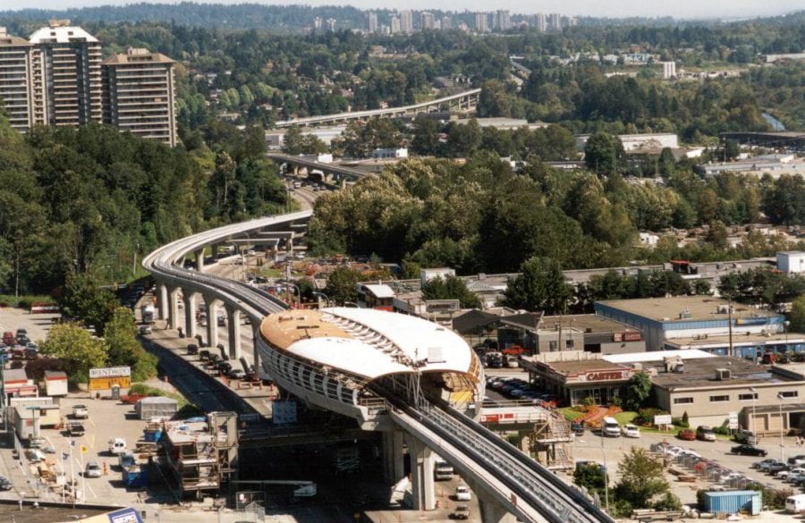
Stations will have a much larger footprint than the elevated line itself. Here's a photo of a recent one on the Victoria BC SkyTrain Millenium Line. I think the width and the stairways/elevators could be made more compact by placing them on the ends of the station rather than in the middle as in this example. Stations should be placed in shopping/retail/commercial squares or locations. Placing one of these alongside low density residential would not be a good idea.

FE-Millennium-Line-3-Brentwood-Station-Credit-NicLehoux-900x585.jpg
.
 
Last edited:
The point is


I didn't doubt it was wide enough I asked why should Cambridge get a tunnel and Dorchester have to settle for an elevated, which is not nearly as good? Hasn't this area been historically underserved? Is that to continue when there is a clear example of what to do, that works, on the other side of the city?
I don't think you asked that question at all. Your argument seemed to be that the old elevated lines sucked, and therefore new ones should be expected to suck. Now that you've asked, the reason would be changes in technology and public works finance. Just because a tunnel was the best option in Cambridge 120 years ago, doesn't mean it's the best option in Dorchester today.
 
My argument is that an elevated is inappropriate for Columbia Road. I think that the extension FROM Harvard that was done in my adult lifetime should serve as the model.
 
The point is


I didn't doubt it was wide enough I asked why should Cambridge get a tunnel and Dorchester have to settle for an elevated, which is not nearly as good? Hasn't this area been historically underserved? Is that to continue when there is a clear example of what to do, that works, on the other side of the city?
And not nearly as expensive
 
In this type of system, how do they implement stations? Do they span the entire road to get access from both sides? How does that access play with sidewalks, bike lanes, travel lanes, etc. ? (The access has to land somewhere.)
You have options. If you have an open plot you can do a ground level station building on one side, you could take add entrances on each sidewalk by removing some street parking and shifting the travel lanes, or you can put the entrance in the median and again take some street parking away for a little plaza area. You can either build all of them with or without a middle mezzanine level for fare control/interchange purposes although option 1 does need some kind of over/underpass so you can get to both platforms.

Some examples:
Eberswalder Straße (Berlin) - Median Entrance, no mezzanine (And no fare control either because Germany)
Erie-Torresdale (Philadelphia) - Side building, no mezzanine (But with overpasses)
Washington/Wabash (Chicago) - Side entrances, with mezzanine
Lechmere (Boston) - Median entrance (kinda sorta), with mezzanine

Width of stations is generally going to be about 55 feet, so an additional 13 feet (ish) on each side of the 'normal' viaduct. This is the biggest area of concern for obstruction of sunlight, so stations need to be placed carefully. This is why I'd generally put the minimum street width for an El at 100 feet and not 75 or 80 feet. The latter is fine(ish) if you don't have stations, but not when you do.
Great examples you show. I would also place stations at major intersections, so the cross-street can accommodate some of the extra width of the station.
 
Great examples you show. I would also place stations at major intersections, so the cross-street can accommodate some of the extra width of the station.
Generally the best approach but it's also worth considering that intersections are sometimes destinations, with attractions and businesses concentrated around them. They also might be built up more, with higher buildings than other parts of the street which compounds with the light-blocking of elevated rail. Yet another thing to file under "Elevated rail can work but be careful about it."
 
I don't know if theres a better place for this, but are folks aware of any studies on the effect of common ticketing in Britain? Ie, there you can buy a single ticket between any two station pairs, regardless of the operator - You can buy a ticket from an random suburban commuter station like Clydebank and be through ticketed on any number of different services through, for example, Fishguard - which would require traveling on no fewer than 3 rail operators.

In particular, I'm wondering if there are plausible ridership and connectivity effects if we were to support such a model regionally on the NEC - allowing someone to book a ticket through from Framingham to say, Raritan NJ or Paoli PA. Those are all connections that exist today, but the friction of buying 3 separate tickets (MBTA/Amtrak/NJT) and the fact that none of those places are shown on the same transit map, I'm realizing that the NEC rail system feels a lot more siloed and unconnected than it necessarily is. This is less a service proposal, but more of a human behavior question, right - its the "you can't get there from here" problem, when in reality you actually can, its just high friction. Boston folks can be expected to know that Framingham to S. Station to get a NE Regional to NYP is doable. Asking them to also know they can get to Atlantic City via NJT @ PHL is less plausible. On a single agency scale it probably doesn't move the needle, but combined the NEC commuter agencies have 700+ unique stations - thats enough potential pairings that there might just be something there without actually touching how the service is provided.

Implementation seems relatively straightforward too - The CR fares on both ends of such a trip are fixed fare "open" tickets in UK rail parlance, with only the NEC Amtrak segment being dynamically priced and reserved seating. You'd just need to fetch the commuter agencies timetables, fare zone logic and station codes, and deliver up to 2 extra QR codes as "boarding passes" for those commuter services.
The UK is hardly the only one to have integrated ticketing, the other two European countries (I'm aware of) that make extensive use of franchising and (semi) private operators are Germany and the Netherlands, and they both have integrated ticketing. Granted nearly 0 people will use anything other than an OV-Chipkaart in the Netherlands but you can buy a single (electronic) ticket from Delfzijl to Kampen across three operators.

Although in all cases I'm aware of this still excludes the open-access operators.
 
It’s always best to be skeptical of the following claim, but in this case I think it has merit: you could build an app for that.

I believe Google Maps actually gets you most of the way there. It currently provides cross-system journey-planning, including via intercity buses. (One caveat below but not insurmountable.)

Where an app could come in is being able to purchase e-tickets from all systems with a single click. (Or touch, I guess, on phones.) This wouldn’t be trivial, as I don’t know whether the systems in question have APIs to buy tickets. You’d also potentially have to “wire up” each system manually — a list which balloons significantly once you start incorporating local bus systems. (As an alternative to APIs, you could potentially have the app open iframes or web views directly to the agency’s ticketing page, with fields pre-populated. A user would need to click through each system, but it would still make the process easier than doing it by hand.)

Thinking out loud here, I would probably start with a proof of concept that covers the following systems:
  • MBTA
  • Shore Line East
  • Hartford Line
  • Metro North
  • New Jersey Transit
  • SEPTA
  • Amtrak
  • Peter Pan
This list favors unified rapid transit + commuter rail systems, and leans toward services in disjointed areas (eg Peter Pan to Springfield + Hartford Line to Connecticut). This is why I’ve excluded NYC Subway and LIRR. (Also because those systems have relatively easy-to-define geographic scopes.)

The caveat with Google Maps is that they haven’t figured out Park-n-Rides/Kiss-n-Rides. For example, if you do a trip from East Providence to New York, it’ll tell you to take RIPTA to Providence Station, instead of what most people would be willing and able to do: get someone to drop them off or use a rideshare. So this would need some consideration, though I guess you could have users’ initial interaction be via a drop down list of stations, which then get fed to Google Maps — that forces the user to make the choice about which station is most convenient for them.
 
  • Shore Line East
  • Hartford Line
  • Metro North
These already have unified ticketing, at least mostly. You can buy a single ticket from Springfield to Grand Central. I believe for Metro North it only applies to New Haven trains, not Waterbury, Danbury, Stamford, or New Canaan services.
The caveat with Google Maps is that they haven’t figured out Park-n-Rides/Kiss-n-Rides.
Or bike-and-rides, to my great annoyance.
 
The UK is hardly the only one to have integrated ticketing, the other two European countries (I'm aware of) that make extensive use of franchising and (semi) private operators are Germany and the Netherlands, and they both have integrated ticketing. Granted nearly 0 people will use anything other than an OV-Chipkaart in the Netherlands but you can buy a single (electronic) ticket from Delfzijl to Kampen across three operators.

Although in all cases I'm aware of this still excludes the open-access operators.
While I'm aware of the EU mandate to separate train operations from track, I also must confess unfamiliarity with how that actually works on the continent- I didn't think its quite as fragmentary as the UK? I could swear the times I've taken trains in those countries I was always on DB or NS, or the system was seamless enough I didn't notice. Either way, here the UK system was just a handy example for me to reach for.
It’s always best to be skeptical of the following claim, but in this case I think it has merit: you could build an app for that.

I believe Google Maps actually gets you most of the way there. It currently provides cross-system journey-planning, including via intercity buses. (One caveat below but not insurmountable.)

Where an app could come in is being able to purchase e-tickets from all systems with a single click. (Or touch, I guess, on phones.) This wouldn’t be trivial, as I don’t know whether the systems in question have APIs to buy tickets. You’d also potentially have to “wire up” each system manually — a list which balloons significantly once you start incorporating local bus systems. (As an alternative to APIs, you could potentially have the app open iframes or web views directly to the agency’s ticketing page, with fields pre-populated. A user would need to click through each system, but it would still make the process easier than doing it by hand.)
well, an app could do it, but I would hesitate to make it a private 3rd party interface when the potential market is a bunch of likely rare pairings. I see this mostly as a endeavor for Amtrak to leverage the commuter agencies more efficiently to feed traffic onto the NEC.
Thinking out loud here, I would probably start with a proof of concept that covers the following systems:

MBTA
Shore Line East
Hartford Line
Metro North
New Jersey Transit
SEPTA
Amtrak
Peter Pan
This list favors unified rapid transit + commuter rail systems, and leans toward services in disjointed areas (eg Peter Pan to Springfield + Hartford Line to Connecticut). This is why I’ve excluded NYC Subway and LIRR.
I think I would, for a phase 1, disagree with favoring transit, and would probably totally exclude local bus. The access points to rapid transit are at existing intercity rail station nodes, and are largely show up and go especially with the advent of tap to pay. Many of the potential pairings of distant CR to distant CR station may not have any bus service on either end and would need to be a pickup/dropoff situation. I don't think theres too much value in integrated ticketing to the local bus in this instance - especially since if you're local to one end you'd likely already know how to get to the station - I don't think a totally integrated transit system is necessary for making rarer connections possible. As you say, I'd be inclined to force the user to pick the station best suited to them. I just want to expand the list of options available when you book an Amtrak ticket to not just be S Station, Back Bay, Rt 128 for Massachusetts, but include all the other stations in the MBTA CR map. That said cross ticketing onto intercity bus is an interesting idea I will need to noodle on a bit more, but I think would be difficult to coordinate with the state agencies, and often not colocated for transfers.

As for LIRR, I think I would include it if for no other reason than it mostly originates at NYP, when Metro North trains largely originate at GCT. When Penn Access is completed it wouldn't be an insurmountable issue, but until then, New Rochelle to 125th to transfer? Its definitely one of the issues I glossed over. The other is North Station originating MBTA services, being the one I've most pointedly ignored for the moment. Absent NSRL, I think I'd only want to make the connections to Southside lines available - it may be a driver for NSRL in the long term, but as a Phase 1 that connection is high friction.
 
While I'm aware of the EU mandate to separate train operations from track, I also must confess unfamiliarity with how that actually works on the continent- I didn't think its quite as fragmentary as the UK? I could swear the times I've taken trains in those countries I was always on DB or NS, or the system was seamless enough I didn't notice. Either way, here the UK system was just a handy example for me to reach for.
I'm not super duper familiar with Germany so there might be some exceptions but in general there is a national infrastructure company (Network Rail, Prorail, DB InfraGo, etc), a national rail operator (DB, Renfe, SNCF, NS, PKP, etc), concession operators (Arriva, Transdev, Keolis, Abellio, etc), and open access operators (Iryo, Italo, Flixtrain, Lumo, etc.)

The infrastructure company owns the rails, signals, and sometimes the stations.

The national rail operator generally runs most routes, especially longer distance and high speed routes.

The concession operators can be contracted by local or regional governments to run a local or regional network.

The open-access operators are entirely for-profit and are not contracted by any government. They will generally offer additional service on major routes like Italo or Iryo operating extra high speed services in Italy or Spain, or Flixtrain offering service on underserved long distance city pairs in Germany, or they can fill a niche not covered by the main operators like Arriva operating late-night trains in some parts of the Netherlands or Snälltåget and European Sleeper operating long distance night trains.
 
Last edited:
The open-access operators are entirely for-profit and are not contracted by any government. They will generally offer additional service on major routes like Italo or Iryo operating extra high speed services in Italy or Spain, or Flixtrain offering service on underserved long distance city pairs in Germany, or they can fill a niche not covered by the main operators like Arriva operating late-night trains in some parts of the Netherlands or Snälltåget and European Sleeper operating long distance night trains.
Addendum: This part can be super controversial. Sometimes it's not like most of the night trains for example. Nobody was operating those services, now someone is, great. (Also, night trains are great, more of them please! And more pack-em-in coaches, I'd like some lower fares.) Where it's tougher is operators like Iryo, Lumo, or Italo, which offer additional services on the busiest routes. It's not unreasonable to say that in most cases if Iryo/Italo/Lumo didn't exist, their slots would be taken by the state-owned operator and there would be more state-owned services intstead. By having a private company operate at least some of the most profitable high demand services, you lose the opportunity to 'balance the books' by having the high-demand routes fund the low-demand routes. You could argue that the net result is the government indirectly subsidizing private companies by letting them operate the high-profit services and take their cut home rather than feeding that money back into the system. The counter-argument is that the private operators put competitive pressure on the state-owned operator to have better or cheaper services but the counter-counter point is that the state-owned operator already has (in theory) political/democratic pressure to do that.

This is the same thing that gets brought up with Brightline. Amtrak stays (kinda) afloat by having the NEC subsidize a whole bunch of the network. If Amtrak had to bid for slots and compete with private operators on the NEC, they wouldn't be able to do this and the results could be cutbacks on the rest of the network.
 
Massachusetts should follow Connecticut's lead and renumber all buses statewide into a single system of 3-digit numbers. This is a first approximation of the map; I'm sure it would need tweaked to reflect the actual distribution of routes.
  • 1 to 199: Greater Boston (approximately inside 128)
  • 200 to 299: South Shore, South Coast, and Cape Cod
  • 300 to 399: Worcester and MetroWest
  • 400 to 499: Montachusett and Lowell
  • 500 to 599: Merrimack Valley and Cape Ann
  • 600 to 699: Springfield and the Pioneer Valley
  • 700 to 799: Berkshires and Franklin County
  • 800 to 899: Owl routes
  • 900 to 999: Regional express routes (including the various private operators)
With a standardized system of suffixes:
  • A, B, C: branches of a single trunk line
  • S: Short turns
  • R: Rapid service with wider stop spacing and priority across the route (BRT or BRT-lite, akin to current Silver Line service)
  • X: Express service with limited stops intended for longer trips

1764630683050.png


Right now, not only are the routes spread out between various RTAs with different information, the numbering is completely random:
  • MBTA: Numbers 1-137; various numbers in the 170s, 200s, 300s, 400s, 500s, and 700s; SL series
  • GATRA: Numbers 1-20; various named routes
  • CCRTA: Named routes
  • SRTA: Numbers 9, 100s, and 200s; one named route
  • WRTA: Numbers 1-42; A and B; one named route
  • MWRTA: Numbers 1-15; various named routes
  • MART: Numbers 1-11; separate numbers for Gardner routes; various named routes
  • LRTA: Numbers 1-20
  • MeVA: Numbers 0-27
  • CATA: Numbers 1-12
  • PVTA: An absolutely unholy abomination of mixed letters and numbers with no apparent pattern
  • FRTA: Numbers 20-41
  • BRTA: Numbers 1-34 plus 921; several 400-series routes planned
  • Several smaller operators with their own branding (Lexpress, Burlington, etc)
  • Various private carriers with little or no public numbering
 
The MBTA should figure out a way to extend the T branding to the other regional bus services if they were to do statewide route numbering. It doesn't need to be a full livery thing, but a T logo on every regional bus in the Commonwealth would, I believe, increase usage outside of the Boston metro.

Now if Charlie Cards could work everywhere in the state we'd really be cooking.
Let's start with Charlie Cards that work everywhere on the T.
 
Now if Charlie Cards could work everywhere in the state we'd really be cooking.
Who needs Charlie cards when tap to pay is an available technology? Seems to be the more logical investment for each RTA to make
 

Back
Top