I finally got around to replying (at some length, because of course) to @TheRatmeister's awesome map, in the Better MBTA Station Names thread.

You are using an out of date browser. It may not display this or other websites correctly.
You should upgrade or use an alternative browser.
You should upgrade or use an alternative browser.
Transit Planning $h!tposting (Ideas so bad, they're good)
- Thread starter Riverside
- Start date
So I recently had a thought thats probably totally insane. We're developing an increasingly contiguous system of railtrails and other separated bike infrastructure, so in those scenarios where we have a separated bike/ped railtrail running on independent RoW, what's the theoretical feasibility of running a relatively low capacity golf cart shuttle along that route? basically... whats the mode compatibility of mixing in 15mph golf carts with ebikes, scooters and pedestrians? Most shared use paths are built to 10-14ft widths, and golf carts are typically 4ft wide and can seat up to 12, would be ZEVs, and probably no more expensive to operate than a van with similar capacity, and if ops costs are a concern, there are a series of autonomous golf carts under development for resort microtransit that could serve this function.
I realise that I'm pushing shared use to its very limits, but if it can work inside an airport or a theme park? and here I'm going to preface that they'd be far better used for active transportation, and where a parallel road corridor is available a full bus service would be preferable. But sometimes there isn't a good parallel road, and the path is just the best option. In the urban case, I'm thinking of a use case where it's a flag & ride model for folks who aren't going to be able to practically use a bike or walk the distance - the mobility impaired, kids, folks with luggage or shopping, along corridors like the Watertown Greenway to Alewife, Upper Falls from Needham to Newton, the Saugus-Lynn segment of the Northern Strand, the future Grand Junction path etc, etc. Those all have notable gaps in their contiguousness, but if solved?
Further out rail trails like Weston to Waltham, the Bruce Freeman are probably better served by parallel roads even if no bus service exists today, as even a van would likely be better than a golf cart, but ymmv on whether a golf cart on the shared use path as a "recreational and transit asset available to the aging local population" would be a more palatable form of transit to NIMBYs in those towns.
I realise that I'm pushing shared use to its very limits, but if it can work inside an airport or a theme park? and here I'm going to preface that they'd be far better used for active transportation, and where a parallel road corridor is available a full bus service would be preferable. But sometimes there isn't a good parallel road, and the path is just the best option. In the urban case, I'm thinking of a use case where it's a flag & ride model for folks who aren't going to be able to practically use a bike or walk the distance - the mobility impaired, kids, folks with luggage or shopping, along corridors like the Watertown Greenway to Alewife, Upper Falls from Needham to Newton, the Saugus-Lynn segment of the Northern Strand, the future Grand Junction path etc, etc. Those all have notable gaps in their contiguousness, but if solved?
Further out rail trails like Weston to Waltham, the Bruce Freeman are probably better served by parallel roads even if no bus service exists today, as even a van would likely be better than a golf cart, but ymmv on whether a golf cart on the shared use path as a "recreational and transit asset available to the aging local population" would be a more palatable form of transit to NIMBYs in those towns.
Last edited:

TheRatmeister
Senior Member
- Joined
- Sep 23, 2023
- Messages
- 1,632
- Reaction score
- 3,342
I think the better solution is to allow private 'vehicles' to use the paths. Of course, "vehicle" in this context means one of these:
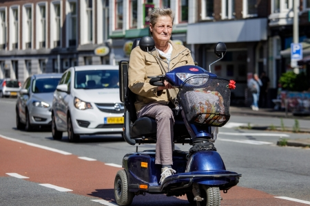
Or maybe (NL is still trying to figure out what to do with these) one of these:
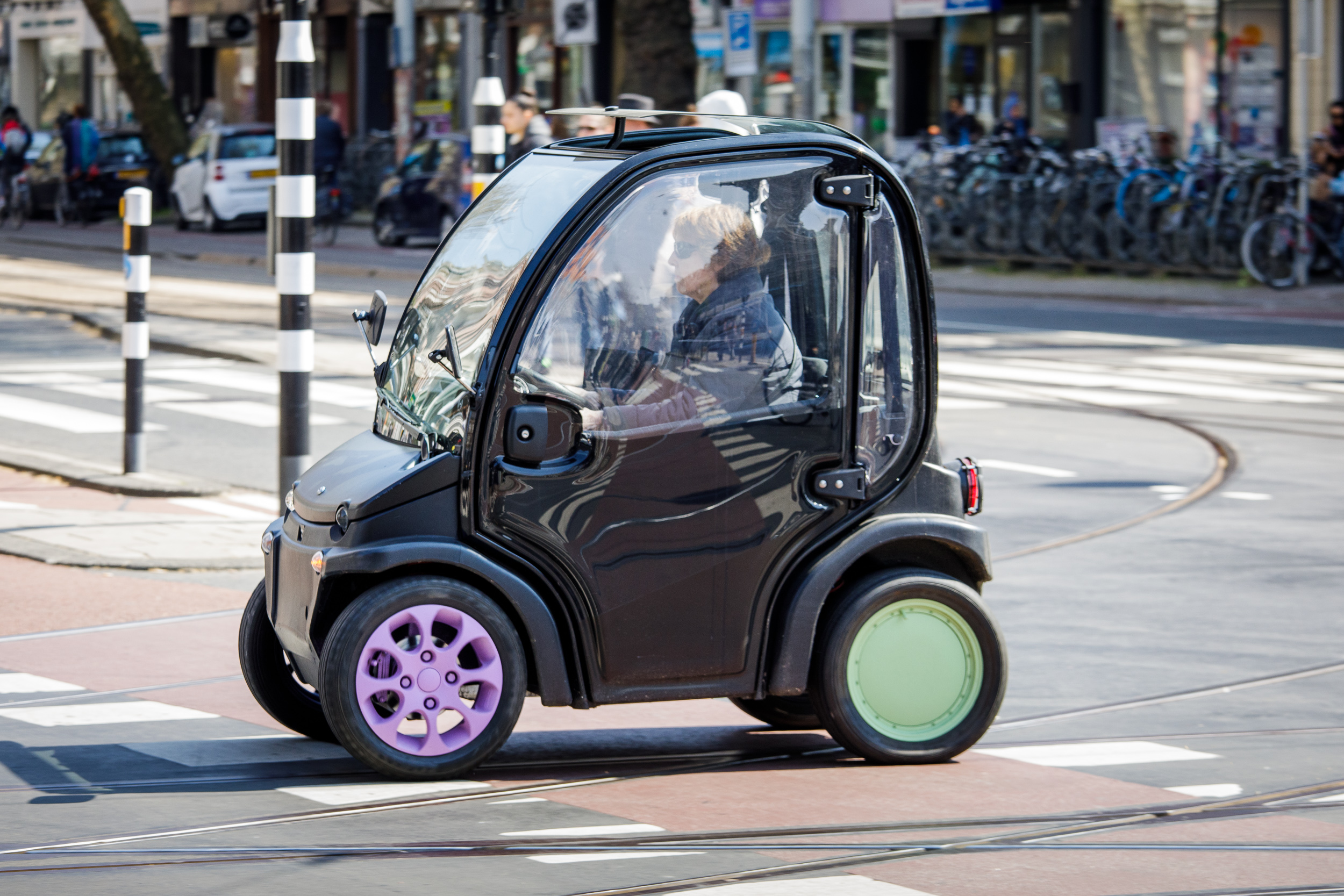
These let you do point-to-point travel and can make better used of sidewalks and bike lanes rather than only full trails, which are and will likely continue to be too limiting for enough journeys to warrant higher capacity microtransit.
Or maybe (NL is still trying to figure out what to do with these) one of these:
These let you do point-to-point travel and can make better used of sidewalks and bike lanes rather than only full trails, which are and will likely continue to be too limiting for enough journeys to warrant higher capacity microtransit.
God--my wife and I have always talked about how Boston would be very cool if golf-cart-like transport was enabled/preferred.
Most of our urban,non-walking, trips are no more than 1-2 miles (just past a comfortable/not too time-inefficient walk) that might be easily transit oriented for some trips, but for others, we'd take a 2+ person rideshare to get around.
We haven't had a car and have lived in the Boston area for 15+ years. If we had little 4-6 person electric golf carts with little heaters/zippered side "curtains" or whatever, it would be perfect. The roads in Boston are small and have a maximum speed of 25mph (for most). Also, parking and space is always at a premium, so these would take up less real estate for both active transport as well as storage.
One can dream.
Most of our urban,non-walking, trips are no more than 1-2 miles (just past a comfortable/not too time-inefficient walk) that might be easily transit oriented for some trips, but for others, we'd take a 2+ person rideshare to get around.
We haven't had a car and have lived in the Boston area for 15+ years. If we had little 4-6 person electric golf carts with little heaters/zippered side "curtains" or whatever, it would be perfect. The roads in Boston are small and have a maximum speed of 25mph (for most). Also, parking and space is always at a premium, so these would take up less real estate for both active transport as well as storage.
One can dream.
Green Line to Littleton
Yup, you read that right. I've got another $h!tpost transit pitch here, 99% unserious, and 1%... well, I'll let you be the judge of that.
I've written elsewhere about how the subway system is the original "North-South Rail Link". This only became more and more true over time as the rapid transit lines relocated onto mainline railroad ROWs. Aside from the Red Line, every transit line operates on an old railroad ROW outside of downtown (except for the B/C/E, although even those all operate in reservations that were set aside for transit use long before the subway was built). This has resulted in redundant modes running side-by-side, providing local and express service. In theory (very much in theory), there could be capacity and efficiency gains by consolidation into a single mode. That is a very thin justification for an exploratory concept, even among $h!tposts, but, we soldier forward.
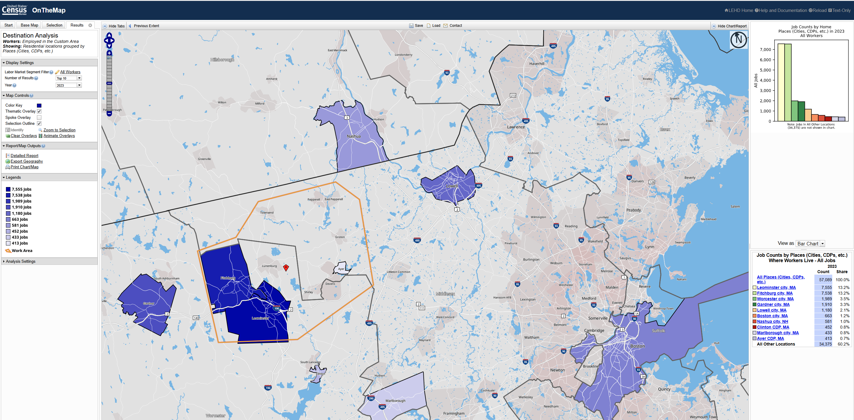
As is typical, the local cities of Leominster and Fitchburg stand head-and-shoulders above other destinations. Worcester and Gardner nearly tie for third. But next will be Boston, right? Right? Nope. It's Lowell. Boston has a bit more than half of the commuters as Lowell, and a bit more than Nashua. So, Fitchburg and Leominster have stronger commute profiles to Lowell, Nashua, and Worcester than to Boston.
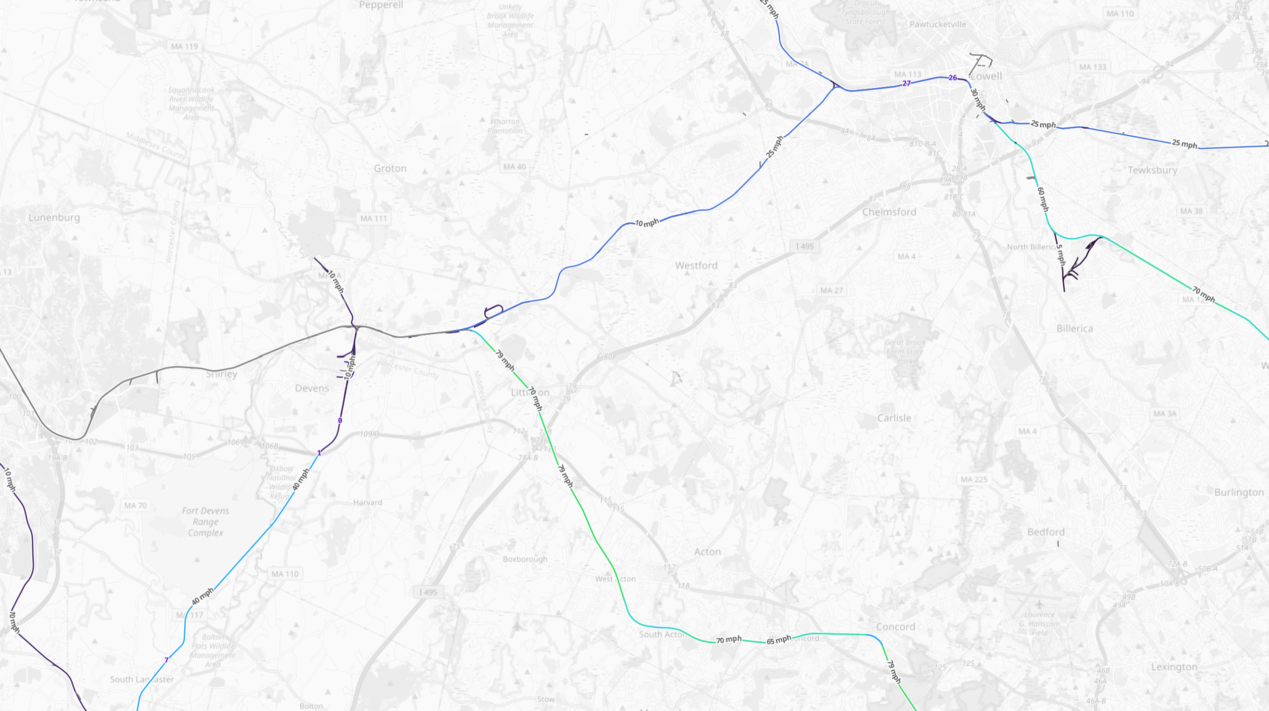
As it happens, there is in fact actively used freight trackage that connects Fitchburg directly to Lowell:
Soooooo what if Outer Fitchburg trains were rerouted over the Lowell Line?
It's a bit longer: Wachusett is 53.7 miles from North Station via Concord, but would be 59.5 miles via Lowell. (BON-Lowell: 25.5 miles; Lowell-Ayer: 16.4 miles; Ayer-Wachusett: 17.6 miles). On the other hand, trains already go faster on the Lowell Line than they do from Littleton/495 -- 33 mph vs 28 mph, which might on its own be fast enough to make up for the longer distance.
But this is where the consolidation of modes potentially makes a difference: with a Lowell-Fitchburg reroute, plus OLX Reading, the Lowell Line trunk would handle the majority of northside traffic... meaning that any infrastructure upgrades it receives would have that much higher ROI, and that much more likely to be funded and built.
Plus, as noted above, there is a significant Fitchburg <> Lowell commuter market. A reroute could (maybe maybe maybe) be equally fast for Fitchburg <> Boston commuters, while significantly expanding the market the service can capture.
But uh yeah so what about riders from Littleton and Concord etc etc?
Well, that's where the Green Line comes in. With commuter rail trains diverted to the NH Main Line, a comfortable double-tracked ROW (with some sections wide enough for four tracks, especially inside of 128) opens up, running directly from Littleton/495 to... the Green Line's Union Square terminus. And many of the Inner and Mid Fitchburg stations are actually pretty well-suited for light rail conversion, in terms of their location and size and grade crossings, etc etc. (And those grade crossings would play nicer with light rail trains that can yield to traffic when needed.)
Running to Littleton/495 would be about 30 miles from North Station. That is definitely long, but it's not unprecedented. This also probably wouldn't be a "Green Line" branch per se. Given its length, it would surely terminate in downtown rather than through-run; its transfer at Porter would mean that the Brattle Loop would be a viable contender (which also helps avoid the capacity crunches at Park St). The quad-track stretches along the Inner section would allow Littleton trains to express past local trains short-turning at Weston (or themselves being extended to Sudbury). And I certainly would not expect 6 minute headways out to Concord; unlike the SUAG (Show Up And Go) frequencies on most of the Green Line, this service would probably be closer to SUAW (Show UP And Wait), and would need to have a published schedule that it can adhere to. But... none of that is particularly insurmountable.
Ultimately, of course, the story here is that the North South Rail Link would allow the in situ mainline services to behave more like rapid transit and accrue more of the benefits thereof. But it is interesting to imagine tackling the problem from the opposite direction.
Anyway, I need to go to bed, but here's a map, with also includes an Airport Rail Link replacing the second bore of the NSRL, with Providence + SCR trains (at SUAG frequencies) curving over to Chelsea and eventually Assembly and Sullivan (and yes, with a connection into the North South Rail Link, enabling all kinds of loop-de-loop shenanigans), while Fram/Wor trains run straight-shot up to the Eastern Route.
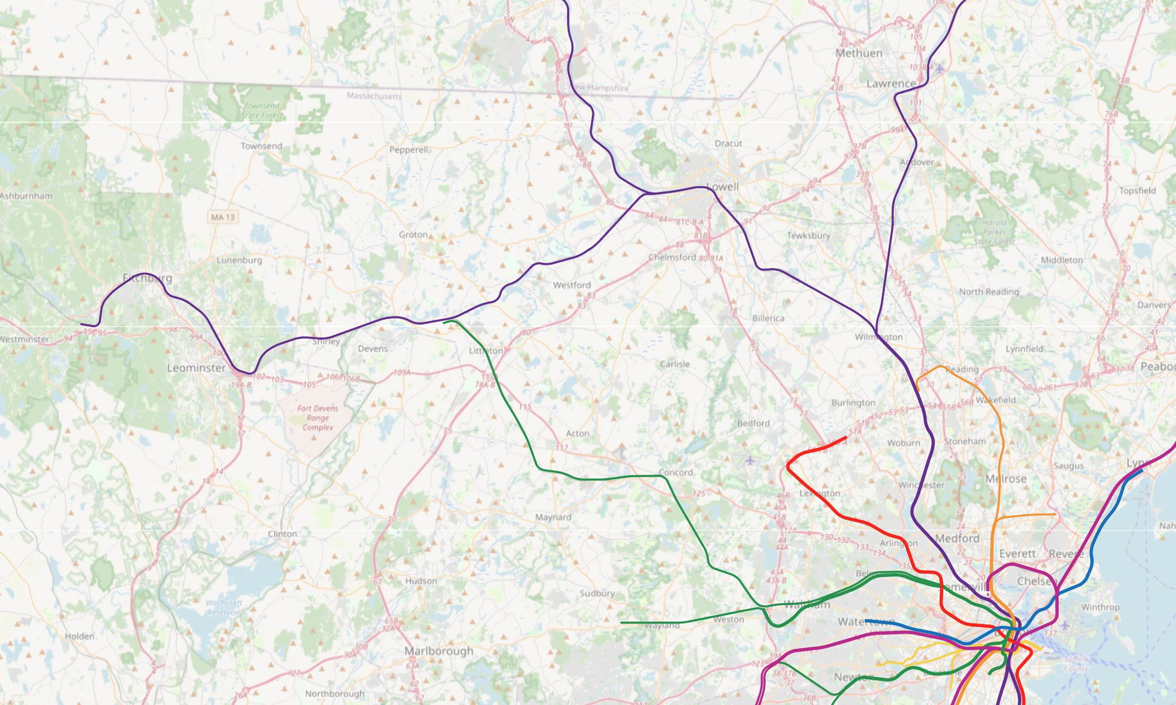
(Don't look too closely at the map.)
Yup, you read that right. I've got another $h!tpost transit pitch here, 99% unserious, and 1%... well, I'll let you be the judge of that.
I've written elsewhere about how the subway system is the original "North-South Rail Link". This only became more and more true over time as the rapid transit lines relocated onto mainline railroad ROWs. Aside from the Red Line, every transit line operates on an old railroad ROW outside of downtown (except for the B/C/E, although even those all operate in reservations that were set aside for transit use long before the subway was built). This has resulted in redundant modes running side-by-side, providing local and express service. In theory (very much in theory), there could be capacity and efficiency gains by consolidation into a single mode. That is a very thin justification for an exploratory concept, even among $h!tposts, but, we soldier forward.
As is typical, the local cities of Leominster and Fitchburg stand head-and-shoulders above other destinations. Worcester and Gardner nearly tie for third. But next will be Boston, right? Right? Nope. It's Lowell. Boston has a bit more than half of the commuters as Lowell, and a bit more than Nashua. So, Fitchburg and Leominster have stronger commute profiles to Lowell, Nashua, and Worcester than to Boston.
As it happens, there is in fact actively used freight trackage that connects Fitchburg directly to Lowell:
Soooooo what if Outer Fitchburg trains were rerouted over the Lowell Line?
It's a bit longer: Wachusett is 53.7 miles from North Station via Concord, but would be 59.5 miles via Lowell. (BON-Lowell: 25.5 miles; Lowell-Ayer: 16.4 miles; Ayer-Wachusett: 17.6 miles). On the other hand, trains already go faster on the Lowell Line than they do from Littleton/495 -- 33 mph vs 28 mph, which might on its own be fast enough to make up for the longer distance.
But this is where the consolidation of modes potentially makes a difference: with a Lowell-Fitchburg reroute, plus OLX Reading, the Lowell Line trunk would handle the majority of northside traffic... meaning that any infrastructure upgrades it receives would have that much higher ROI, and that much more likely to be funded and built.
Plus, as noted above, there is a significant Fitchburg <> Lowell commuter market. A reroute could (maybe maybe maybe) be equally fast for Fitchburg <> Boston commuters, while significantly expanding the market the service can capture.
But uh yeah so what about riders from Littleton and Concord etc etc?
Well, that's where the Green Line comes in. With commuter rail trains diverted to the NH Main Line, a comfortable double-tracked ROW (with some sections wide enough for four tracks, especially inside of 128) opens up, running directly from Littleton/495 to... the Green Line's Union Square terminus. And many of the Inner and Mid Fitchburg stations are actually pretty well-suited for light rail conversion, in terms of their location and size and grade crossings, etc etc. (And those grade crossings would play nicer with light rail trains that can yield to traffic when needed.)
Running to Littleton/495 would be about 30 miles from North Station. That is definitely long, but it's not unprecedented. This also probably wouldn't be a "Green Line" branch per se. Given its length, it would surely terminate in downtown rather than through-run; its transfer at Porter would mean that the Brattle Loop would be a viable contender (which also helps avoid the capacity crunches at Park St). The quad-track stretches along the Inner section would allow Littleton trains to express past local trains short-turning at Weston (or themselves being extended to Sudbury). And I certainly would not expect 6 minute headways out to Concord; unlike the SUAG (Show Up And Go) frequencies on most of the Green Line, this service would probably be closer to SUAW (Show UP And Wait), and would need to have a published schedule that it can adhere to. But... none of that is particularly insurmountable.
Ultimately, of course, the story here is that the North South Rail Link would allow the in situ mainline services to behave more like rapid transit and accrue more of the benefits thereof. But it is interesting to imagine tackling the problem from the opposite direction.
Anyway, I need to go to bed, but here's a map, with also includes an Airport Rail Link replacing the second bore of the NSRL, with Providence + SCR trains (at SUAG frequencies) curving over to Chelsea and eventually Assembly and Sullivan (and yes, with a connection into the North South Rail Link, enabling all kinds of loop-de-loop shenanigans), while Fram/Wor trains run straight-shot up to the Eastern Route.
(Don't look too closely at the map.)

themissinglink
Senior Member
- Joined
- Jan 13, 2018
- Messages
- 2,201
- Reaction score
- 6,283
Interesting idea. It would be nice to expand light rail service to some of the denser suburban towns, since so many of those towns used to have trolley service.Green Line to Littleton
Yup, you read that right. I've got another $h!tpost transit pitch here, 99% unserious, and 1%... well, I'll let you be the judge of that.
I wish that Commuter Rail service to Gardner never ended, even though ridership was low.As is typical, the local cities of Leominster and Fitchburg stand head-and-shoulders above other destinations. Worcester and Gardner nearly tie for third. But next will be Boston, right? Right? Nope. It's Lowell. Boston has a bit more than half of the commuters as Lowell, and a bit more than Nashua. So, Fitchburg and Leominster have stronger commute profiles to Lowell, Nashua, and Worcester than to Boston.
Here's my unserious proposal for a Green Line extension to MetroWest:
Last edited:
@Riverside There are some neat ideas in there. Especially consolidating everything onto the Lowell line so there's better ROI on investments there.
The downside there is then you have to do 34 miles of significant track upgrades from Lowell to Fitchburg on reeealy crummy, ~10mph freight tracks.
Also, Green Line trains are slower than commuter rail, so this would be a long trip from Littleton. I'd want more comfortable seating, at least.
Still, I've thought a few times about how to use that Fitchburg to Lowell line for passenger rail. This is better than anything I've come up with.
Here, just because Lowell is in the top five on that list doesn't actually make it a "significant" commuter market. Only 2% of commuters are coming from Lowell, or only about 1000 people. You could try to guess what modeshare you might win with your plan, but I think you'd be drastically changing a commuter line to accommodate, generously, under 200 people?
Also, your map is only showing where people are coming from to work in that area. If you also look at where people in Fitchburg/Leominster travel to for work, then the existing Fitchburg line looks a lot better. Boston: 3,399, Cambridge: 1,180, Waltham: 1,014, West Concord: 338, Somerville: 223 ..... Lowell: 787. Plus there are just more things in Boston people would travel for other than commuting, like going to school, shows, or sports games, hospitals, dining, etc.
I've been getting super interesting in Airport Rail Links. What exactly is the idea here?
The downside there is then you have to do 34 miles of significant track upgrades from Lowell to Fitchburg on reeealy crummy, ~10mph freight tracks.
Also, Green Line trains are slower than commuter rail, so this would be a long trip from Littleton. I'd want more comfortable seating, at least.
Still, I've thought a few times about how to use that Fitchburg to Lowell line for passenger rail. This is better than anything I've come up with.
As is typical, the local cities of Leominster and Fitchburg stand head-and-shoulders above other destinations. Worcester and Gardner nearly tie for third. But next will be Boston, right? Right? Nope. It's Lowell. Boston has a bit more than half of the commuters as Lowell, and a bit more than Nashua. So, Fitchburg and Leominster have stronger commute profiles to Lowell, Nashua, and Worcester than to Boston.
I just want to flag this. It looks like a kind of logical fallacy I see kind of often from people writing about transit (and one I accidentally commit sometimes, for sure). By some metric, something will appear near the top of a list and is thus deemed "significant." Or something is at the bottom of a list and is deemed "unimportant." But in a lot of these cases, where something falls on an ranked list doesn't really matter. It's raw numbers of people that matter (or housing units, or commuters, or whatever your metric is). As simple examples: a line might have a station that is technically busiest, but still only serves a tiny fraction of total riders. Or there could be a huge dropoff in whatever metric past the first couple on the list, so third place is effectively tied with everyone else for last. Or a station could be the least used on a line, but still be reasonably busy. The rank is often far less informative than the actual numbers for whatever metric you use to get the rankings.Plus, as noted above, there is a significant Fitchburg <> Lowell commuter market.
Here, just because Lowell is in the top five on that list doesn't actually make it a "significant" commuter market. Only 2% of commuters are coming from Lowell, or only about 1000 people. You could try to guess what modeshare you might win with your plan, but I think you'd be drastically changing a commuter line to accommodate, generously, under 200 people?
Also, your map is only showing where people are coming from to work in that area. If you also look at where people in Fitchburg/Leominster travel to for work, then the existing Fitchburg line looks a lot better. Boston: 3,399, Cambridge: 1,180, Waltham: 1,014, West Concord: 338, Somerville: 223 ..... Lowell: 787. Plus there are just more things in Boston people would travel for other than commuting, like going to school, shows, or sports games, hospitals, dining, etc.
here's a map, with also includes an Airport Rail Link replacing the second bore of the NSRL, with Providence + SCR trains (at SUAG frequencies) curving over to Chelsea and eventually Assembly and Sullivan (and yes, with a connection into the North South Rail Link, enabling all kinds of loop-de-loop shenanigans), while Fram/Wor trains run straight-shot up to the Eastern Route.
Don't look too closely at the map?! Lol. It's a map. I can't not.(Don't look too closely at the map.)
I've been getting super interesting in Airport Rail Links. What exactly is the idea here?
F-Line to Dudley
Superstar
- Joined
- Nov 2, 2010
- Messages
- 10,112
- Reaction score
- 12,905
This. The speed differential between a 79 MPH-capped Regional Rail EMU set and a 50 MPH-capped Green Line set gets excruciating after a certain distance and a certain stop spacing, nevermind the relative creature comforts of the livery and relative total quantities of seats you have to be carrying butts for such a long distance. If we're pouring this much money into the Fitchburg corridor as a given, don't assume a comparison with current diesel push-pull schedules...assume a comparison with stock EMU's that lop 20-22% off Littleton all-local travel times. 60 minutes over 30 miles today becomes 46-48 minutes and a much higher average speed for the stop spacing. Green Line is only going to beat a mainline EMU if you have inner city stop spacing every couple thousand feet the whole way (which would be intolerable for the distance and outlying density). It's almost certainly going to take you longer to get to 495-land in any rapid transit vehicle vs. simply EMU'ing the Purple Line at its current authorized track speed. This is what those Concord state reps who proposed the wacky Red Line extension to Concord a couple weeks ago don't understand; the rolling stock speed differential is going to make it much worse transit that far out to change modes vs. simply improving the current mode to its full-and-reasonable potential. I don't think you'd EVER want to change the mode outside of 128 on this corridor (and if not changing the mode you have no reason for the Lowell-Ayer re-route). The stop spacing outside of Waltham city limits is never going to get packed any tighter; the density for it simply doesn't exist outside of maybe an infill/revival of the West Acton stop as trade-in for the Weston stop consolidation. The only place the Green Line starts making more sense is where you're significantly densifying the stop spacing...and that is only going to be a net-positive TO 128 (and only if the putative GLX displaces most of the Purple Line stops such that all Purple trains become a Porter-128 express), not beyond 128.Also, Green Line trains are slower than commuter rail, so this would be a long trip from Littleton. I'd want more comfortable seating, at least.
There's a reason the New England trolley interurbans went belly-up in the era (1920's) immediately before car ownership became critical-mass widespread. They weren't very good long-distance travel options compared to the RR's...slow, too-dense stop spacing to too-diffuse density, uncomfortable livery for the travel distance. They only made sense because the fare structures were much lower than the federally rate-regulated RR's...but unsustainably low fares were the very thing that caused those interurban companies to go bankrupt en masse once that bubble burst, because the quality-of-service couldn't compete. The glory days of that bubble are not going to be recaptured by hyper-expanding the rapid transit system into "new" long-distance interurbans, because that just invites the same quality problems that held back the mode in the first place. You do better bending the RR's to better/faster service gears within their wheelhouse than you do with a mode change, at least as far as the 128-to-495 belt goes and travel to the nearest Gateway cities goes. We've kind of had this sorted conceptually ever since the 1940's transit expansion studies: rapid transit working best for local service in the density TO 128, but beyond that well-optimized RR's gain the upper hand.
Oh booooooooooo I forgot to toggle between the Live and Work options on OnTheMap, that’s terribleAlso, your map is only showing where people are coming from to work in that area. If you also look at where people in Fitchburg/Leominster travel to for work, then the existing Fitchburg line looks a lot better. Boston: 3,399, Cambridge: 1,180, Waltham: 1,014, West Concord: 338, Somerville: 223 ..... Lowell: 787. Plus there are just more things in Boston people would travel for other than commuting, like going to school, shows, or sports games, hospitals, dining, etc.

I take your point, but on the other hand that Lowell figure seems decent enough to me — lower than Waltham but not that far off.If you also look at where people in Fitchburg/Leominster travel to for work, then the existing Fitchburg line looks a lot better. Boston: 3,399, Cambridge: 1,180, Waltham: 1,014, West Concord: 338, Somerville: 223 ..... Lowell: 787. Plus there are just more things in Boston people would travel for other than commuting, like going to school, shows, or sports games, hospitals, dining, etc
That said, that Waltham figure is the real thing that knocks down a Fitchburg-Lowell Reroute: Waltham (and Cambridge) are decently strong destinations, so splitting them off is a pretty big drawback.
Perhaps if Lowell ends up with excess capacity that leads to some trains short-turning rather than continuing to NH, perhaps in that case those might get extended to Fitchburg as supplemental service, but it would be pretty far down the priority list.
Yeah, if there’s ever a world where “light commuter rail” becomes common, I imagine it will have rearranged/refurbished interiors, even if it interlines with conventional cars.Also, Green Line trains are slower than commuter rail, so this would be a long trip from Littleton. I'd want more comfortable seating, at least.
I agree with you in general, though I think my question would be how quickly/how long the EMU set actually exceeds 50mph (I know Seattle’s LRT hits 55, FWIW).The speed differential between a 79 MPH-capped Regional Rail EMU set and a 50 MPH-capped Green Line set gets excruciating after a certain distance and a certain stop spacing,
I’m actually generally pretty skeptical of/opposed to a mainline cross-harbor tunnel to Logan, under most circumstances, for reasons that have been discussed elsewhere. But in this case, it occurred to me that the ROI of a cross-harbor tunnel increases if it can also serve Chelsea (and Everett). I haven’t thought through it in great detail, but it was a throwaway map, and it was on a similar theme of “consolidated routes to increase ROI on trunks”, so I tossed it in.I've been getting super interesting in Airport Rail Links. What exactly is the idea here?
F-Line to Dudley
Superstar
- Joined
- Nov 2, 2010
- Messages
- 10,112
- Reaction score
- 12,905
Technical explainer: http://tillier.net/stuff/caltrain/diesel_vs_elecloco_vs_emu.pdfI agree with you in general, though I think my question would be how quickly/how long the EMU set actually exceeds 50mph (I know Seattle’s LRT hits 55, FWIW).
It takes 2:18 over 2.5 miles of non- curve-restricted track for a stock (B)EMU (i.e. the same general make and class the T is buying for Fairmount) to reach 79 MPH vs. 2:36 for a diesel. They also accelerate to the first 43 MPH twice as fast as the fastest push-pull loco. You can extrapolate from there to general conclusions with the stop spacing on the Fitchburg Line. It's about 4 miles from the would-be Weston/Route 128 replacement station to Lincoln, 3.4 miles from Lincoln to Concord, 1.8 miles from Concord to West Concord, 3.4 miles from West Concord to South Acton, and 4.8 miles from South Acton to Littleton (assume that distance can be chopped roughly in half by a West Acton infill). And other than West Acton there's no other viable infill candidates between 128 and 495, not even bringing back the other Weston stops at greater frequency. The Fitchburg Line has fairly moderate curvature overall on the stretch and at least two long straightaways, so you'd definitely have some tangible amount of time >50 MPH on the trek between 128 and 495. Enough to easily pull away from a 50 MPH-capped Green Line.
It's inside-128 where there's a much larger crop of potential infills in Cambridge, Belmont, and Waltham where trolleys would perform better. But instead of trying to uni-mode it and shoot away that advantage by either having the bulkier EMU's get bogged down in urban stop-spacing on the inner portion or the trolleys struggle with track speed on wide spacing on the outer portion...simply draw the modal line at 128 and have each mode be purpose-fit for its dense-spacing vs. not-dense-spacing audience. They can be side-by-sided on this corridor inside 128, after all.
Oooh, that's why you were using that map.Oh booooooooooo I forgot to toggle between the Live and Work options on OnTheMap, that’s terrible
An annoyingly easy mistake to make. On The Map is such a great tool, but some of wording in those toolboxes is ambiguous and always seems to do the opposite of how I interpret them.
I see where you're getting those numbers, but I think that's a little tangential to what the question was. @Riverside was asking how long EMUs would actually be going faster than 50mph, so the 2.5 mile test or comparisons to diesel are kind of irrelevant. (sorry if I'm just misinterpreting what you're saying.)It takes 2:18 over 2.5 miles of non- curve-restricted track for a stock (B)EMU (i.e. the same general make and class the T is buying for Fairmount) to reach 79 MPH vs. 2:36 for a diesel.
This is the relevant graph, right? So that EMU will accelerate to 50mph over about 0.2 miles, and up to 79mph over 0.7 miles. Deceleration stats seems to really depend on a bunch of stuff, but close-enough-for-our-purposes you could consider it symmetrical. There are 17 stops.** Really, really roughly that leaves 47 of the 54 miles where the train could be going faster than 50mph. And that leaves about 24 of 54 miles where the train could max out track speed. That's extremely back-of-the-envelope, but yes, the EMUs would spend a lot of time going faster than an LRT train.
** 17 stops on the whole Fitchburg Line, because I forgot you were only considering as far as Littleton. But I don't feel like redoing the math, and you get the point.
Hey @Riverside , I saw someone posting about this tool, and it reminded about this recent conversation.
 cartoview.blogspot.com
It's a python script for QGIS that measures track geometry for a line, calculates max possible speeds along the line, and simulates your choice of train along the line to come up with a timetable (with lots of caveats). Obviously there are professional tools that do that, but this looks possibly amateur-accessible. I haven't tested it out at all, but it looks like it could give you some idea of the speed difference between the Green Line and Regional Rail EMU up to Littleton.
It also just looks like a fun little tool to play with. If anyone gets it running, there are all kinds of historic or abandoned rail ROWs that it would be fun to run on. Or if anyone knows of other, similar, amateur-accessible tools, I'd love to know.
The Railway Curvature & Timetabling Tool
A QGIS tool for asking "how fast could this railway actually go?" Suppose you have a railway: if you rebuilt this line properly, how fast ...
cartoview.blogspot.com
It's a python script for QGIS that measures track geometry for a line, calculates max possible speeds along the line, and simulates your choice of train along the line to come up with a timetable (with lots of caveats). Obviously there are professional tools that do that, but this looks possibly amateur-accessible. I haven't tested it out at all, but it looks like it could give you some idea of the speed difference between the Green Line and Regional Rail EMU up to Littleton.
It also just looks like a fun little tool to play with. If anyone gets it running, there are all kinds of historic or abandoned rail ROWs that it would be fun to run on. Or if anyone knows of other, similar, amateur-accessible tools, I'd love to know.

Delvin4519
Active Member
- Joined
- Oct 8, 2022
- Messages
- 962
- Reaction score
- 1,657
One problem with the Orange Line today is that it is not necessarily "direct" for travelling from one side of the suburbs to the other side's suburbs; taking a windy route through the city.
Hence; a terrible idea to "straighten" the Orange Line with a more direct path to eliminate the annoying curvy route with a straight shot route.
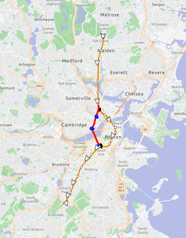
Stops would reuse the existing Sullivan Station; new stops at Lechmere and Kendall MIT. Back Bay Station would need to be approached from the northwest rather than the east; meaning a reconfiguration of the station is necessary. The northern and outer ends of the Orange Line remain as is.
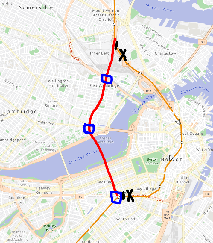
Through end-to-end riders would be able to save travel time by no longer having to endure the New England Medical Center slowzone; and avoid having to endure stops on every other block downtown with fewer stops on a straighter, more express routing from one side of downtown to the other side of downtown. The existing present day routing between Sullivan and Back Bay would remain as a shuttle train where you can transfer at Sullivan and Back Bay to the regular Orange Line. (This also opens a path to extending the shuttle train to Everett via the 109 bus routing).
(See, it's clearly too curvy and frustratingly indirect) |
Hence; a terrible idea to "straighten" the Orange Line with a more direct path to eliminate the annoying curvy route with a straight shot route.
Stops would reuse the existing Sullivan Station; new stops at Lechmere and Kendall MIT. Back Bay Station would need to be approached from the northwest rather than the east; meaning a reconfiguration of the station is necessary. The northern and outer ends of the Orange Line remain as is.
Through end-to-end riders would be able to save travel time by no longer having to endure the New England Medical Center slowzone; and avoid having to endure stops on every other block downtown with fewer stops on a straighter, more express routing from one side of downtown to the other side of downtown. The existing present day routing between Sullivan and Back Bay would remain as a shuttle train where you can transfer at Sullivan and Back Bay to the regular Orange Line. (This also opens a path to extending the shuttle train to Everett via the 109 bus routing).
Last edited:

Charlie_mta
Senior Member
- Joined
- Jul 15, 2006
- Messages
- 5,297
- Reaction score
- 8,112
That's an intriguing idea. I would add a stop at the Charles River Esplanade for a transfer to a BLX line to Kenmore (via Charles). Also, the to-be abandoned Orange Line through Downtown and Charlestown could be repurposed as a Green Line to Nubian Sq to the south and to Everett/Chelsea to the north, or maybe as a NS commuter rail/Amtrak tunnel (if the tunnel dimensions are large enough for that, which I doubt).One problem with the Orange Line today is that it is not necessarily "direct" for travelling from one side of the suburbs to the other side's suburbs; taking a windy route through the city.
View attachment 74713 View attachment 74716
(See, it's clearly too curvy and frustratingly indirect)
Hence; a terrible idea to "straighten" the Orange Line with a more direct path to eliminate the annoying curvy route with a straight shot route.
View attachment 74718
Stops would reuse the existing Sullivan Station; new stops at Lechmere and Kendall MIT. Back Bay Station would need to be approached from the northwest rather than the east; meaning a reconfiguration of the station is necessary. The northern and outer ends of the Orange Line remain as is.
View attachment 74720
Through end-to-end riders would be able to save travel time by no longer having to endure the New England Medical Center slowzone; and avoid having to endure stops on every other block downtown with fewer stops on a straighter, more express routing from one side of downtown to the other side of downtown. The existing present day routing between Sullivan and Back Bay would remain as a shuttle train where you can transfer at Sullivan and Back Bay to the regular Orange Line. (This also opens a path to extending the shuttle train to Everett via the 109 bus routing).
TheRatmeister
Senior Member
- Joined
- Sep 23, 2023
- Messages
- 1,632
- Reaction score
- 3,342
It's an interesting idea for what to do with one of the three (ish) good remaining alignments through Downtown. I'd say the timesaving arguement doesn't hold up especially well, it seems like it would be about ~9 minutes compared to 10-11 currently, but I'm sure plenty of Malden riders would appreciate a 1SR to Kendall and that cross river connection would be super popular.
Delvin4519
Active Member
- Joined
- Oct 8, 2022
- Messages
- 962
- Reaction score
- 1,657
With all the talk of Needham extensions; and rapid transit eating CR extensions; here's another unserious proposal for the Blue Line to be extended from Beverly all the way to Needham and Riverside (and Peabody for good measure)Here's my unserious proposal for a Green Line extension to MetroWest:
But wait; both of the Needham and Riverside termini end at loops, so why stop there? There's still the option to restore the Needham <-> West Rox connection; and add the long awaited Allston-Brighton subway, plus Reading, Everett/Linden, and the Grand Junction extensions. The "Blue Loop" completed but better,
Also; subway rolling stock and platform dimensions can be simplified and standardized; by having the Blue Line eat the Orange Line entirely (OL stations/platforms wll be reconfigured to have the correct dimensions to match the BL). We can give one seat rides from East Boston to Kendall; if you're willing to ride all the way out to Riverside and back in. And just for measure; I've also restored a few historical stations on this extended Blue Line, to ensure the elimination or truncation of some unnecessary bus routes; plus I've added redundency to mitigate the annoying Orange Line and Green Line shutdowns by routing the Blue Line through Back Bay; as the random weeklong or weekend suspensions of Green Line and Orange Line service can be quite frustating for spontaneous off peak travel and weekday peak travel. (Cannot state how much a Green Line trolley every 5-7 minutes at Govy or Haymarket is incapable of handling the crush during OL shutdowns). This adds the much needed buffer redundency against those random weeklong or weekend GL/OL shutdowns. (We also free up capacity in the Green Line tunnel by having Blue eat the Highland Branch). It techincally works, some have suggested "OLX to Needham Heights", or "BLX to Kenmore"; but stringed together into one extension on of a single line.
(I suppose instead of Reading; we can extend the Orange; or I guess, Blue Line back to Peabody; or finish the Saugus Branch run in lieu of a Northgate terminus; if you actually wanted to "finish the loop").
On the flip side; you get trains every 5 minutes between Newton Highlands and Salem Depot in a single one seat mode; bu it will be quite the lengthy trip of a ride.
Last edited:
Delvin4519
Active Member
- Joined
- Oct 8, 2022
- Messages
- 962
- Reaction score
- 1,657
Green Line to Littleton
Soooooo what if Outer Fitchburg trains were rerouted over the Lowell Line?
I think this idea can go a lot further. Not only can outer Fitchburg trains be rerouted over to the Lowell Line, but also have middle Fitchburg trains rerouted over to the Worcester/Framingham line. Thus; we don't have to extend the Green Line all the way out to Littleton; but we can just extend the Green Line to Waltham; and then throw in some extra frequency to the Newton stations by sending some trains from Littleton over to West Newton, and run to South Station.
At first glance, the absence of a railroad ROW between Waltham and Riverside might be troubling; but on the flip side; there is route 128 and the Mass Pike at our disposal; which here works out to an advantage.
So.... what if a viaduct got built between the Waltham ROW and the West Newton ROW via the median of Route 128 to connect the 2 railroad ROWs... and then reroute middle Fitchburg trains to run to downtown via the Pike; on top of rerouting outer Fitchburg trains to the Lowell line.
The end result being is that we only need a Green Line extension to Waltham. The "Fitchburg Line" is eliminated entirely; instead being absorbed by an extension of the Lowell Line to Fitchburg; and a branch of the Framingham/Worcester Line to Littleton supplementing the Newton/MassPike stations with additional frequency.
In this modified version of the "Fitchburg+Haverhill Line eliminated" concept; provided are 3 Green Line extensions; one via East Watertown then median running 57/39-style via Arsenal to Watertown Sq; plus 2 branches serving north and south Waltham. I suppose the Waltham branches can terminate at Govy. (or alternatively; the north Waltham branch can be omitted, or run as a Mattapan-style dinky shuttle trolley), and for good measure; I've extended the Medford Branch to West Medford. via Route 16.
Last edited:
F-Line to Dudley
Superstar
- Joined
- Nov 2, 2010
- Messages
- 10,112
- Reaction score
- 12,905
You probably wouldn't need to do a viaduct to connect the B&A with the Fitchburg. Shifting the whole 128 alignment 1 lane to the west and compressing the extremely wide left shoulders a little bit should create more than enough room for 2 RR tracks at-grade between Weston and Waltham along the reservoirs.
The problem is that it's going to wreck B&A capacity to have to feed another mainline as a branch. If 2 tracks of the B&A inside 128 only project to have about 10 TPH of capacity, :30 all-locals to Framingham take up 4 TPH, :30 semi-expresses to Worcester take up 4 TPH, and Amtrak is eventually going to round up to eat the last 2 TPH. Something's going to have to get gutted to fit in 4 TPH branching to Littleton/Wachusett, and that's probably going to mean making the 4 TPH of thru-Worcesters load-bearing for all local stops inside of Framingham at excruciating pain point for the added end-to-end travel time, with no possibility of any future Northborough/Clinton branch service because the Framingham all-local layer that would otherwise effortlessly feed that extension is diverted to the Fitchburg Line. Thus, the megaproject you're going to incur ends up being the billions it'll take to tri-track the innermost B&A by shifting the whole Pike alignment with lots of land-takings in Newton, Brighton, and Back Bay.
I mean, you can do GLX-Waltham 2 x 2 alongside the Fitchburg Line all points east of the ex-Central Mass split at Beaver St. with no more disruption than a little bit of embankment reshaping and reconfig of the more recent Waverley Station grade separation, and way fewer private land-takings than GLX-Medford + the Community Path had to do to widen the Lowell cut. The Fitchburg was entirely a 3-4 track railroad there in ancient days. Then swap the Fitchburg Line to the Central Mass ROW between Beaver St. and 128 and let GLX claim the existing Waltham Center-Brandeis ROW for itself, meeting back up at the 128 superstation. And do it all for cosmically less $$$ and controversy than trying to infrastructurally make the Worcester Line carry the west-of-Boston world on its back.
The problem is that it's going to wreck B&A capacity to have to feed another mainline as a branch. If 2 tracks of the B&A inside 128 only project to have about 10 TPH of capacity, :30 all-locals to Framingham take up 4 TPH, :30 semi-expresses to Worcester take up 4 TPH, and Amtrak is eventually going to round up to eat the last 2 TPH. Something's going to have to get gutted to fit in 4 TPH branching to Littleton/Wachusett, and that's probably going to mean making the 4 TPH of thru-Worcesters load-bearing for all local stops inside of Framingham at excruciating pain point for the added end-to-end travel time, with no possibility of any future Northborough/Clinton branch service because the Framingham all-local layer that would otherwise effortlessly feed that extension is diverted to the Fitchburg Line. Thus, the megaproject you're going to incur ends up being the billions it'll take to tri-track the innermost B&A by shifting the whole Pike alignment with lots of land-takings in Newton, Brighton, and Back Bay.
I mean, you can do GLX-Waltham 2 x 2 alongside the Fitchburg Line all points east of the ex-Central Mass split at Beaver St. with no more disruption than a little bit of embankment reshaping and reconfig of the more recent Waverley Station grade separation, and way fewer private land-takings than GLX-Medford + the Community Path had to do to widen the Lowell cut. The Fitchburg was entirely a 3-4 track railroad there in ancient days. Then swap the Fitchburg Line to the Central Mass ROW between Beaver St. and 128 and let GLX claim the existing Waltham Center-Brandeis ROW for itself, meeting back up at the 128 superstation. And do it all for cosmically less $$$ and controversy than trying to infrastructurally make the Worcester Line carry the west-of-Boston world on its back.
Talking about orange line reroutes had me wondering: what if back in the 70s and 80s the T had dumped what money it spent on RLX to Alewife and Braintree and OLX to Forest Hills and Oak Grove into a new S-bahn-like(?) system, utilizing the OL tunnel through downtown and rail ROW that was yet to be fully abandoned. While it would require tunneling from Back Bay to Kenmore and from Tufts Medical Center down to south of Andrew, almost all of it could utilize existing ROW, with just about enough space to be completely separated from regional rail. That plus signaling + ops improvements could get you as good as 10-15 minute frequencies on all 5 branches.
I don't know if it would be a better situation than we have today, but it would be hard to argue with this kind of coverage.
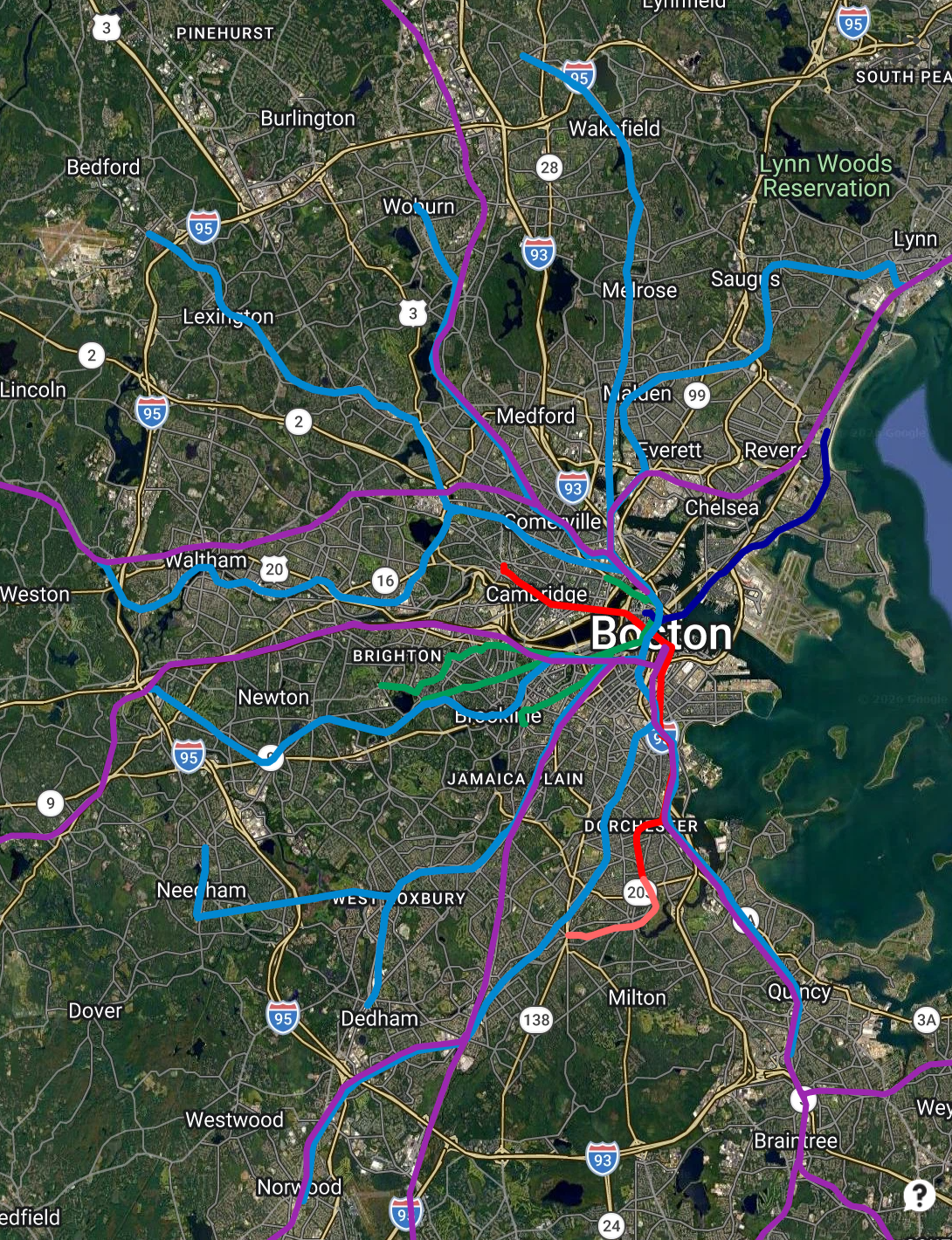
I don't know if it would be a better situation than we have today, but it would be hard to argue with this kind of coverage.
If we're crayoning the state rail map across Central MA with abandon... I have two thoughts. Mostly, I think you'd get 90% of the connectivity benefit, if not more, by just running a proper Providence-Worcester-Lowell, if it's speedy enough and timed to meet the Fitchburg at Ayer. I know that as far as MA Intrastate rail goes we're really focused right now on East-West and compass rail, but I really do think a PVD-WoR-Lowell service would complement it beautifully.
I would hope that in the distant future we can get it with a combo platter with DMU Ag Branch service all the way from Mansfield via the Framingham & Fitchburg subs to Leominster, meeting every 30 minute Regional Rail transfers at each crossing line? Juicy interwoven rail network please.
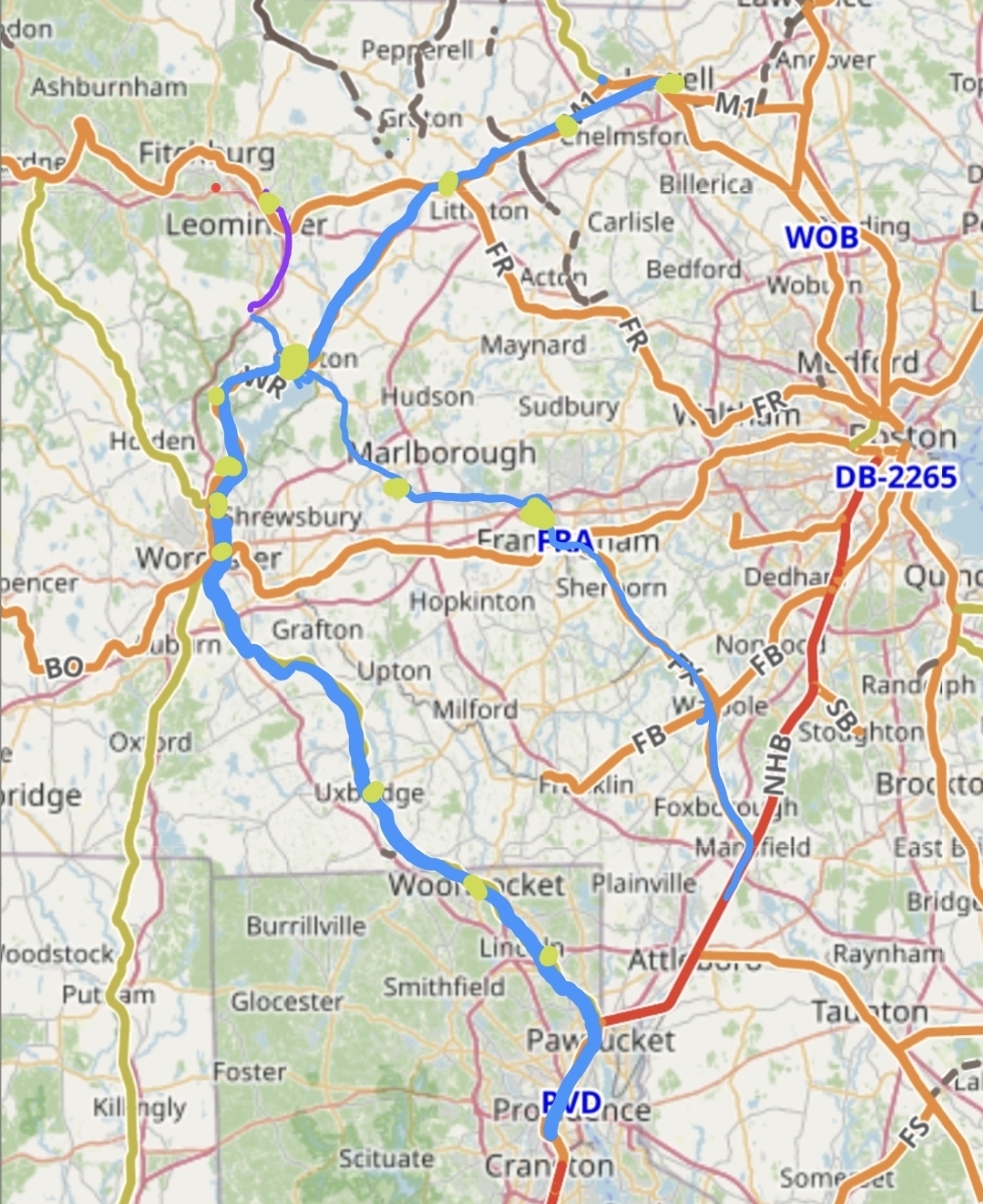
For the Mansfield to Leominster line, I'm thinking DMUs with station stops of Mansfield (stub track in parking lot) Foxboro Center, Gillette, Walpole, Medfield, Framingham, (platform on the Wye), Framingham Center, Marlborough Junction / Southborough, Northborough, Clinton Union, N. Leominster, Fitchburg) rejoining the Fitchburg Line by running alongside I190 from Pratts Junction to North Leominster - I'm envisioning this along the lines of a 2 car, maybe even low floor DMU dinky, (I know there isn't a FRA compliant one, let me dream) in the vein of those thin European branch lines. the chief appeal to me being these are old railroad towns, and that particular alignment of towns and cities is actually kinda annoying to drive.
Crossing at Clinton Junction, a Providence-Worcester-Lowell line could serve as RI Intrastate, but if it originates in Providence, I'm thinking station stops at Lincoln/Cumberland, Woonsocket, Uxbridge, Northbridge, Millbury, your choice of Worcester Infills, W. Boylston, Clinton Union, Devens, Ayer, Westford, Lowell.
I would hope that in the distant future we can get it with a combo platter with DMU Ag Branch service all the way from Mansfield via the Framingham & Fitchburg subs to Leominster, meeting every 30 minute Regional Rail transfers at each crossing line? Juicy interwoven rail network please.
For the Mansfield to Leominster line, I'm thinking DMUs with station stops of Mansfield (stub track in parking lot) Foxboro Center, Gillette, Walpole, Medfield, Framingham, (platform on the Wye), Framingham Center, Marlborough Junction / Southborough, Northborough, Clinton Union, N. Leominster, Fitchburg) rejoining the Fitchburg Line by running alongside I190 from Pratts Junction to North Leominster - I'm envisioning this along the lines of a 2 car, maybe even low floor DMU dinky, (I know there isn't a FRA compliant one, let me dream) in the vein of those thin European branch lines. the chief appeal to me being these are old railroad towns, and that particular alignment of towns and cities is actually kinda annoying to drive.
Crossing at Clinton Junction, a Providence-Worcester-Lowell line could serve as RI Intrastate, but if it originates in Providence, I'm thinking station stops at Lincoln/Cumberland, Woonsocket, Uxbridge, Northbridge, Millbury, your choice of Worcester Infills, W. Boylston, Clinton Union, Devens, Ayer, Westford, Lowell.
Last edited: