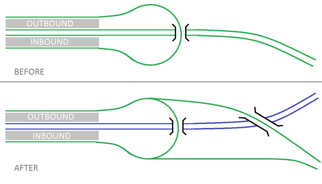
I love this thread. So far we've tackled south side and Seaport extensions via the Tremont Street Tunnel (and possibly also via new Essex Street and/or new Back Bay tunnels), and now we've talked about the northside GLX to Porter and beyond.
One of the extensions I'm missing from this is Everett/Chelsea via the Eastern Branch, to the airport. I think this is an important possibility because:
1) Casino transit
2) Everett redevelopment potential
3) Alon's dictum of looking at the busiest bus routes - Chelsea is exhibit uno
4) The fact that this route forms an essential part of the urban ring
5) The fact that SL Chelsea is already happening
I'm sort of skeptical about this, at least if the plan is to use commuter rail ROW. Commuter rail modernization is more useful here.
Now, you might ask, what's the difference between this and the GLX on the Lowell and Fitchburg Lines? My answers are,
1. First, it wasn't my decision to build the GLX instead of modernizing commuter rail, adding frequent infill stops, and coming up with a schedule that allows local and longer-range trains to share tracks if express service to Lowell is desired.
2. The Fitchburg Line has longer-range demand than the Eastern Line, which has weak demand north of Beverly. The Lowell Line doesn't, but has a potential extension to Manchester that would make it long-range as well. This means that frequent stops in Cambridge and Somerville are more problematic for the Fitchburg and Lowell Lines than for the Eastern, making a GLX more useful.
3. Development near the inner Lowell and Fitchburg is continuous, favoring frequent stops, whereas it isn't on the Eastern south of Chelsea. This means that a modernized Eastern Line could make do with fewer infill stops, which would both simplify scheduling (no express trains are needed, see point #2) and favor higher-top speed commuter trains.
4. Conversely, because there's a less circuitous bus, rail to Chelsea should be faster and have fewer stops, which again favors commuter rail.
5. The Watertown branch favors a GLX, since a commuter rail setup with locals going via Watertown and expresses going via the existing line would be awkward. It would also require grade separations: new mainline rail lines are built grade-separated, even if in theory the electrification infrastructure is the same as that for light rail.
6. A GLX to Chelsea would require a new water crossing, adding to the cost. Mind you, I also think the existing GLX should have cost maybe 1/8 what it really did - it's an existing ROW, FFS - but when a water crossing is required, higher costs happen for legitimate reasons.
Instead of a GLX to Chelsea, I'd propose modernizing commuter rail, then, including infill stations in Everett at Broadway, in Revere at Winthrop and at Revere, and maybe also in Chelsea at Eastern. Maybe a Blue Line branch, but I'd be wary: Maverick and Airport are the two busiest stops on the line, but Wonderland is a close third, and a Lynn extension would put further pressure on the existing line.