Cambridge Crossing (NorthPoint) | East Cambridge/Charlestown | Cambridge/Boston

Good for them - the placeholder street names were garbage, and their new namesakes certainly seem worthy of the honor.

Interesting that the developer was willing to eliminate names that do not fit with new Cambridge Crossing brand. Don't mean to be cynical but....
 
These are good street names. If only the Seaport had done the same...
 
Dp5uIwuV4AAfbiL.jpg


Retail-2.jpg


1093-c05.jpg


cx3a.png


071418i-Cambridge-Crossing-building.jpg


egNyfYBh.jpg


3d-visualization-cx-07.jpg


Divco-Cambridge-Crossing-REND-Parcel-Q-view-from-Parcel-I.jpg


Good to see the triangle plot where the old Lechmere turnaround is being removed from is being developed and reincorporated into the street grid.

CX_MapContent_HP_Final_@1.5x_SiteOverview.jpg
 
Last edited:
Street name changes have been approved. Here was the request: http://rwinters.com/council/040119M1-StreetNames.pdf

North Point Blvd -> Morgan Ave & Education Cir

Dawes St -> Water St

North St -> Jacobs St

I'd have eliminated the cheesy "Education Circle" and extended Morgan Avenue to the river, but I'll take it. Of course, I'd love to see a similar map like this for the Seaport ASAP.
 
Some day, they should build another bridge across the tracks and 93 on the north side of this development (maybe a viaduct from 3rd St to Inner Belt Rd, with ramps down to Northpoint). As it is, it's always going to be a dead end place off to the side, since it has limited connection to the surrounding neighborhoods... thereby limiting amount of activity, retail, etc. I suspect this place is going to feel a lot like the West End for a very long time.
 
Some day, they should build another bridge across the tracks and 93 on the north side of this development (maybe a viaduct from 3rd St to Inner Belt Rd, with ramps down to Northpoint). As it is, it's always going to be a dead end place off to the side, since it has limited connection to the surrounding neighborhoods... thereby limiting amount of activity, retail, etc. I suspect this place is going to feel a lot like the West End for a very long time.

Nah, the West End is distinctly suburban in layout. Thankfully, the recent built-from-scratch developments (including this) have largely avoided that.

I expect this to end up like a smaller and lower-profile Seaport Square, with which this has a similar office and residential density. It won't have the same retail vibrancy of Assembly. A downside comparison would be CambridgePark Drive, but they're planning enough active ground floor usage to avoid that.

Just put enough there there and it'll be fine.
 
I suspect this place is going to feel a lot like the West End for a very long time.

You don't become like the West End by accident. The West End is the West End very much on purpose. Cambridge Crossing is trying to be open and active, and I suspect the retail section will end up feeling quite a bit like Assembly, actually.
 
Just by this having roads that connect with the rest of the neighborhood instead of the buildings walling off the outside world with only 1 road in or out and a bunch of cauldesacs ensures this WONT be like the west end.
 
There should be a lot of pedestrian and bike traffic thanks to this being the link between the GLX path and the charles river path. Might give it a bit of life.
edit: on that point, there doesn't seem to be protected bike lanes which is a shame. Is there a reason for that?
 
You don't become like the West End by accident. The West End is the West End very much on purpose. Cambridge Crossing is trying to be open and active, and I suspect the retail section will end up feeling quite a bit like Assembly, actually.

The west end comparison may have been a bit of an exaggeration. Don’t let that distract you from my core point… Which is that this is a development that is tucked away and essentially a dead end, and if you don’t have through traffic, you were going to be severely limited in terms of any sort of vibrancy...we’ll see, but they should be thinking long range about more connections... in general, there should be more connections across those tracks, anyway.
 
1456167983679


By virtue of everyone that uses the green line will have to get on and off the train right there I dont see it. Its about as connected as it could be to the streets too, idk I just dont see it.


I shared these upthread but you can see Lechmere in the background.

Divco-Cambridge-Crossing-REND-Parcel-Q-view-from-Parcel-I.jpg


The building in the center above is the one on the left below.

egNyfYBh.jpg


Which is across the street from this

1093-c05.jpg


So going right past Lechmere on first st leads into this, labelled as “retail square” in the first pic above.

071418i-Cambridge-Crossing-building.jpg
 
Last edited:
Stick, some of what you posted has been updated (significantly) ...

1) There is no "retail square" since Lot I's building emplacement has changed (there should be a performance/circle-in-the-round at the plot's north end);

2) Lots J and K were joined, with the combined lot nearing completion;

3) Lots E and F were joined, and are under construction;

4) Lot G was enlarged, with the new section shifted northward (and under construction);

5) Lot H was slightly enlarged, with the new section shifted northwestward (and also under construction);

6) Q has been split into Q1 and Q2, with one handling retail and the other some unspecified substructure connected to the metro head houses;

7) The plots of A, B, and C-D are different now, too, but their changes not material;

8) W is at the north end of the park ("above" R), and represents the first retail segment to open in Nov/Dec 2019.

You are correct that folks will filter through CX from either of the two headhouses (or down through Sanofi (G & H) from the Gilmore Bridge)...
 
I know I guess it was confusing, but I said “going past Lechmere on first st leads into this”... then posted the render showing what goes in the area that is labelled retail square on that street map. I was using the render to show what its like not the map. 
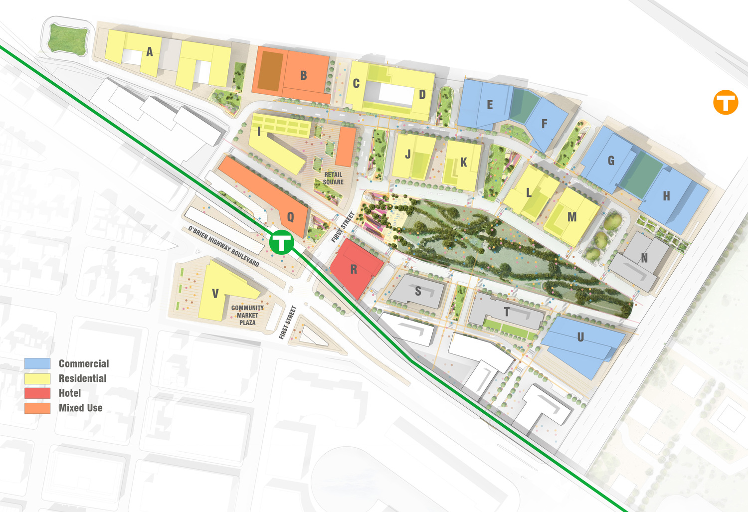
Thats because theres no updated street map, or at least I dont have a new one. The renders are current though. The retail square still exists, it just looks different... shown in the posted renders.

Anyways I only shared that as a response to the previous post to show where Lechmere is in regard to the streets, and that its not tucked away. Its gone through quite a few changes and iterations, but the street map was just to show the main streets. The actual renders are there to show what it looks like now. Post 1166 up further shows more too.


This is the most current “map”, which I shared further up too, which isnt totally accurate either, so theres not a ton of options. Ill try to find the most current and accurate street map I can.

CX_MapContent_HP_Final_@1.5x_SiteOverview.jpg
 
Last edited:
By virtue of everyone that uses the green line will have to get on and off the train right there I dont see it. Its about as connected as it could be to the streets too, idk I just dont see it.


I shared these upthread but you can see Lechmere....

I am not sure if you realize that every time you post multiple renders, you interrupt the thread and often shift conversations to a new page. In this case, the exact same images have been posted by you, twice, on a single page. Please try to exercise some restraint and consideration… It was not too long ago that on here, it was considered bad form to post any images that had already been posted earlier in the thread. There are plenty of cases where words or a link to an image will suffice.
 
Last edited:

Back
Top