Then and Now

Judging by the vent in the modern picture, I'd say something to do with the subway. Probably a vent, possibly egress.

I was thinking egress as well...kinda like the idea of an access point there.
 
It was an emergency exit from the T station -- the upper inbound platform, if I remember correctly. During construction of the Alewife extension, it served as an entrance to Harvard-Holyoke station.
 
Whoops!. Exit was from the upper, outbound platform.
 
Cambridge Street in the West End, looking east near Joy Street. The portal was in existence until the 1950's when the Orient Heights Blue line yard was built, and the portal was no longer needed for Blue Line cars to be towed to the Red Line on Longfellow Bridge, to use the Elliot Yard at Brattle Square.

Then (the early 1900's):

14940937693_1ba1905f27_z.jpg


Now:

15558437951_25c794ebd9_z.jpg
 
Depressing. Only a single building in that shot remains till today, and it's been all mucked up.
 
1952, when the portal was sealed and being filled in soon after Orient Heights opened. . .
18131scr_ce6ea0a74f8066c.jpg


Road was half-ruined by this point due to the 1930's widening.
 
photostream


i always wondered why there was a bridge to the world trade center - it looked old as did the building - well, looks like there's always been a viaduct, over train tracks originally. this whole aerial set is pretty awesome...

ugh, cant make the image appear but link is here:
https://www.flickr.com/photos/boston_public_library/5334162492/in/photostream/

also - question - whats the story with the second BU bridge in this
https://www.flickr.com/photos/boston_public_library/5333543297/in/photostream/
picture? ive never seen it and the link in the page is dead. google is also useless....
 
Last edited:
I found out (see above):
Googled the hell out of it, found this: http://cambridge.dlconsulting.com/c...230623-01.1.6&e=-------en-20--1--txt-IN-----#

TEMPORARY BRIDGE OVER CHARLES BEGUN
Construction' of a temporary bridge between Boston aiid this city, at a point nearly opposite St. Marys Street on the Boston side, was begun on Tuesday by the Metropolitan District Commission. It is expected the structure will be completed by September. It. will take the place of the Cottage Farm bridge during the construction of the new permanent bridge. Until the temporary bridge is completed the present Cottage' Farm, bridge will be used. Under an act passed by this year's Legislature, the control of the structure has passed for the present to the Metropolitan District Commission. -

An appropriation of $15,000 has been made for necessary repairs. These will have to be made to keep the bridge in condition for use until the temporary one at St. Marys Street is finished. The latter will be available for pedestrians and vehicular traffic. .\ext Fall the commission expects to let a contract lor the building of the permanent Cottage Farm bridge. When that is done the removal of the present one at Cottage Farm will take place. In iact. the contract lor the new structure will include the removal of the present. Meanwhile the temporary bridge will be available.

Couldnt find a bridge on any old aerial but now i have my answer.
 
Random factoid: the street where the temporary bridge connected is listed as "Ashby Street" on old maps. It was later covered over by Marsh plaza.
 
Interesting.. seems more in keeping with a cottage farm name (mason, essex etc) than st mary's.

Last question for anyone out there - the BRA has some great historic maps (http://www.bostonredevelopmentauthority.org/research-maps/maps-and-gis/historic-maps - really nice renders of SW Expressway etc) that appear to be revamped versions of their former urban renewal plans. But if you examine the 1994 Boston Major Thoroughfares map, it shows Glen Road (Green St) in JP continuing up the hill right into Franklin Park. I dont remember there being traffic on the park roads, other than circuit drive. Is this an erroneous holdover from an older map, or were there multiple auto roads in the park even in 1994? I think it's erroneous, since the map also shows a pre-Orange line street layout for some of the roads around Green St Station...
 
Fay Street, looking NW from Harrison Avenue

December 2002
fay_street_12-2002.jpg


December 2014
fay_street_12-2014.jpg


I took the first photo 12 years ago, just before the Gateway Terrace project completely transformed the block. This project is in my opinion one of the most underrated of the past decade. It consists of three separate buildings, the Emerson, the Hallet, and the Vose that filled gaps and completed the street wall along Washington, East Berkeley, and Harrison. All three buildings are modest in scale and so well designed and contextual that I wouldn't be surprised if many people walk by them every day and never even realize they were completed less than ten years ago.

In the 2002 photo we're looking up Fay Street at the back sides of buildings on Washington Street (and East Berkeley Street to the right). The taller building on the left is the building with the three arched bays to the left of the Vose in this photo.

In the 2014 photo the street is transformed by the Emerson on the left and the Hallet on the right. The only buildings that appear in both pictures are the backs of the only two remaining brick row houses on this stretch of Washington in the center, and the back corner of 1134-1140 Washington Street to their right. You can also make out the top of the Hancock Tower in both photos.
 
this is technically "then" - "then" in this case being 1999. i looked through all the individual sites and was amazed at how almost every single project has been successfully redeveloped. really nice job. also stunned to be reminded of the change on washington street; went to the paramount this weekend and cant believe it's only been 12 yrs since it and everything else on this block was abandoned.
http://www.historicboston.org/casebook/99cb/contents.htm
 
I think this actually probably belongs here, but I had posted first in 2024 and Im making a link from the 2024 thread....

The loop track itself was in place by the late 1930s (on a 1938 aerial) though not too far before then. Use of the space inside for business happened between the 1955 and 1969 aerials.

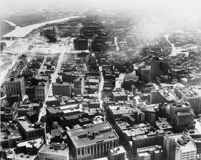
Bringing it back to Widett and some tangential historical geography which I doesn't fit neatly into any particular thread (yes, there really needs to be several different subtopics for these Olympics) - those historic aerials (here) are pretty cool. I always forget how recently it was that South Bay got filled in. In the 1942 aerial, the bay is still pretty big and there's even the stub of the canal that paralleled Albany St, running down to Mass Ave. (which, long ago in I think pre-industrial revolution times, the city's industries - turpentine, paint and leadworks were located, roughly around Albany & Melnea now). Also something I didn't know - if you look at pre-Melnea, Southampton crossed Mass Ave and hit Northampton in what appears to be a sort of large square, that now is covered up by that Hampton Inn and a much bleaker Northampton St.

Anyway, assuming those USGS maps are correct, the land for Widett was filled between 1943 and 1944, with the rail loop immediately constructed upon it. On 
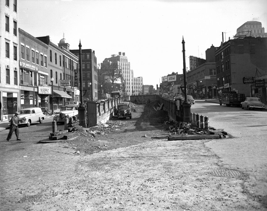
this post from 2012, you can see the patch of land that became Widett, sandwiched between the main canal of the much-filled in South Cove, and a small "tributary" channel that ran all the way to south of Southampton St (shown on 1938 aerial, truncated to the now-Fairmount Line in 1955, shown on the USGS topo for 1967 but gone in the 1969 aerial - which is also when the roads and businesses of Widett are shown for the first time. I would guess that this photo below is from the mid 50's, since the New York Streets area has been just cleared.

chinatown.png
 
Depressing. Only a single building in that shot remains till today, and it's been all mucked up.

Davem -- if you look at the BPL archive
https://www.flickr.com/photos/boston_public_library/6309385748/in/photostream/

you can see that a lot of the destruction occurred around 1920 when Cour and Cambridge Streets were widened to ease the traffic congestion in Scollay Sq., Bowdoin Sq., and Leverett Circle

But there are buildings just behind one or two prominent ones in the early photo which appear to have been moved -- not destroyed
 
photostream


i always wondered why there was a bridge to the world trade center - it looked old as did the building - well, looks like there's always been a viaduct, over train tracks originally. this whole aerial set is pretty awesome...

ugh, cant make the image appear but link is here:
https://www.flickr.com/photos/boston_public_library/5334162492/in/photostream/

also - question - whats the story with the second BU bridge in this
https://www.flickr.com/photos/boston_public_library/5333543297/in/photostream/
picture? ive never seen it and the link in the page is dead. google is also useless....

FK -- that Fairchild Aerial photo of the South Boston Seaport is one of the best of Boston aerials that I've seen -- comparable to the famous balloon photo of DTX by taken in 1860 by James W. Black
"from the balloon, Queen of the Air, owned by Samuel Archer King. This image is the first successful aerial photograph taken from a balloon in the United States"
http://www.celebrateboston.com/first/aerial-photo.htm

5060829306_0d00ce36e8_z_BostonPictorialArchive.jpg

Note the steeple of Old South at the Corner of [in the Left slightly below center] Washington Street slants to the lower right while Milk St. curves up and back to the left toward the harbor

modern-style map of the 1872 street layout
map_Boston_1872.gif

Much of whats in the Black photo was destroyed in the Great Boston fire and so everything changed except for the footprints of the streets

Much of what is in the Fairchild photo [rail yards and warehouses] -- today's parking lots -- is going to be the new Seaport / Innovation District

In 10 or so years, only the Commonwealth Pier building, the Fish Pier, and the footprints of the other piers, and a remnant of the cluster of buildings @ Summer & D Streets in the foreground will remain
 
Last edited:
1952, when the portal was sealed and being filled in soon after Orient Heights opened. . .
18131scr_ce6ea0a74f8066c.jpg


Road was half-ruined by this point due to the 1930's widening.

F-Line -- the Fairchild Aerials at the BPL show the whole from a high oblique angle taken from the Cambridge side

https://www.flickr.com/photos/boston_public_library/5334160134/in/photostream/

Boston Public Library
Boston. West End and business district from East Cambridge
File name: 08_02_000662

Box label: Fairchild aerial photos: Downtown Boston (incl. harbor): High obliques (Greater Boston)

Title: Boston. West End and business district from East Cambridge

Alternative title:

Creator/Contributor: Fairchild Aerial Surveys, inc. (photographer)

Date issued:

Date created: 1928

Note these are very high res and can be highly enlarged
 
Just a "Then" but a cool one.

Hayward Place back in the early 1960s. Now site of Millennium Place.


Back
Top