MBTA Buses & Infrastructure

With all this stuff about a redesigned bus network, I was wondering what people thought of as the next logical bus priority/BRT street? I think Mass Ave is probably the one that would make the most sense, but, now on the Mass Ave bridge, they just took out 1 lane to create bike lanes on the bridge. There's at least a short bus lane on the Boston side and ones going to the bridge on the Cambridge side. Maybe they can redo the bike lanes and create bus lanes too?

congestion is never that bad in the middle of the bridge, even during peak travel hours. The main part of the design is ensuring that the bus has a queue jump at the red lights on both ends.
 
congestion is never that bad in the middle of the bridge, even during peak travel hours. The main part of the design is ensuring that the bus has a queue jump at the red lights on both ends.
There is going to be at least some bus lane on the bridge outbound to Cambridge: don't know where or how it transitions, though.
mabsi2.png
 
The Mass Ave bus lanes are already striped (red markings haven't gone down yet - probably too cold at this point). They're at both sides of the bridge approaching Boston and Cambridge - probably a couple hundred feet long each).

For other BRT projects, I think BostonBRT has a decent tracker for projects in the pipeline (there's also a map on their site).

Other big projects that are in the works are the extension of Columbus Ave, Blue Hill Ave, and the North Station - Seaport corridor all in Boston. Some others have been announced, too, but I haven't heard anything major for Mass Ave (it'd be one of the few corridors the T initially ID'ed that needed bus lanes that hasn't gotten that treatment in Boston at least).

Now that the Bus Network Redesign is done and with all the funding available for BRT projects, I'd be surprised if the T wasn't gonna double down on more projects in the years to come.
 
As current projects go:
  • Columbus/Tremont, Malcolm X, Warren, and Blue Hill Avenue - so much of the Roxbury/Dorchester bus ridership is funneled through these corridors
  • North Washington/Congress/Summer - desperately needed to make connections that the existing rapid transit network doesn't make well
  • Mass Ave: should have continuous bus lanes from Arlington Center to Upham's Corner. The bridge is the worst section; unfortunately, there's no way to have bus lanes and bike lanes until we add outrigger spans / a separate bike span.
Others:
  • The entire LMA - one of the most congested parts of the city, and one of the busiest nodes on the bus network, and currently bereft of any bus lanes
  • Broadway, Broadway, and Broadway: East Somerville, Everett, and Revere/Chelsea all need full-time full-length bus lanes
  • Harvard Square - so much time is wasted getting the 71/73, 1, 66/86, and 77 in and out of the square.
  • The BU Bridge/Mem Drive rotary - at PM peak, this can literally add half an hour to the 47.
I'm not as familiar with these locations, but the density of routes suggests a lot of potential benefit:
  • Ashmont to Codman Square and to Gallivan
  • Arborway/Morton Street, especially near Forest Hills
  • BUMC/Boston Medical Center area
  • Watertown to Newton Corner
 
I've always thought an expansion of the Harvard Bus Subway that would allow it to serve the 66, 1 and 69 would be an interesting project.
 
As current projects go:
  • Columbus/Tremont, Malcolm X, Warren, and Blue Hill Avenue - so much of the Roxbury/Dorchester bus ridership is funneled through these corridors
  • North Washington/Congress/Summer - desperately needed to make connections that the existing rapid transit network doesn't make well
  • Mass Ave: should have continuous bus lanes from Arlington Center to Upham's Corner. The bridge is the worst section; unfortunately, there's no way to have bus lanes and bike lanes until we add outrigger spans / a separate bike span.
Others:
  • The entire LMA - one of the most congested parts of the city, and one of the busiest nodes on the bus network, and currently bereft of any bus lanes
  • Broadway, Broadway, and Broadway: East Somerville, Everett, and Revere/Chelsea all need full-time full-length bus lanes
  • Harvard Square - so much time is wasted getting the 71/73, 1, 66/86, and 77 in and out of the square.
  • The BU Bridge/Mem Drive rotary - at PM peak, this can literally add half an hour to the 47.
I'm not as familiar with these locations, but the density of routes suggests a lot of potential benefit:
  • Ashmont to Codman Square and to Gallivan
  • Arborway/Morton Street, especially near Forest Hills
  • BUMC/Boston Medical Center area
  • Watertown to Newton Corner
I wholeheartedly support the expansion of bus lanes -- and most as indicated make sense.

But this is all nonsense until we have a real enforcement mechanism to keep bus lanes clear. Right now none of our existing bus lanes do their job because of illegal travel, stopped delivery and parked vehicles.

Yeah, we definitely need camera-based enforcement, which many other transit systems have (NY, AC Transit in the East Bay, SF, etc.), but it's also about design. I've gotten to ride the Columbus Ave lanes a lot in the last year, and there's noticeably less driving / parking in the bus lanes given the center-running design. Hopefully this becomes the preferred approach moving forward and more side-running bus lanes get phased out or enhanced as design standards and the network evolve. I feel like a decent comparison is when Boston went from all the striped bike lanes rolled out under Menino in 2008-10 and then transitioned to doing more separated bike facilities starting in 2015-6 under Walsh.
 
Last edited:
With all this stuff about a redesigned bus network, I was wondering what people thought of as the next logical bus priority/BRT street? I think Mass Ave is probably the one that would make the most sense, but, now on the Mass Ave bridge, they just took out 1 lane to create bike lanes on the bridge. There's at least a short bus lane on the Boston side and ones going to the bridge on the Cambridge side. Maybe they can redo the bike lanes and create bus lanes too?
What I would do is widen the bridge, 1 lane on each side, pushing the sidewalks out to the new outer edges of the widened bridge, creating interior room for the bus lanes. The bridge is a simple design, so it would be easy to add piers and girders on each side. Easier than the N Washington St Bridge!
 
  • Harvard Square - so much time is wasted getting the 71/73, 1, 66/86, and 77 in and out of the square.

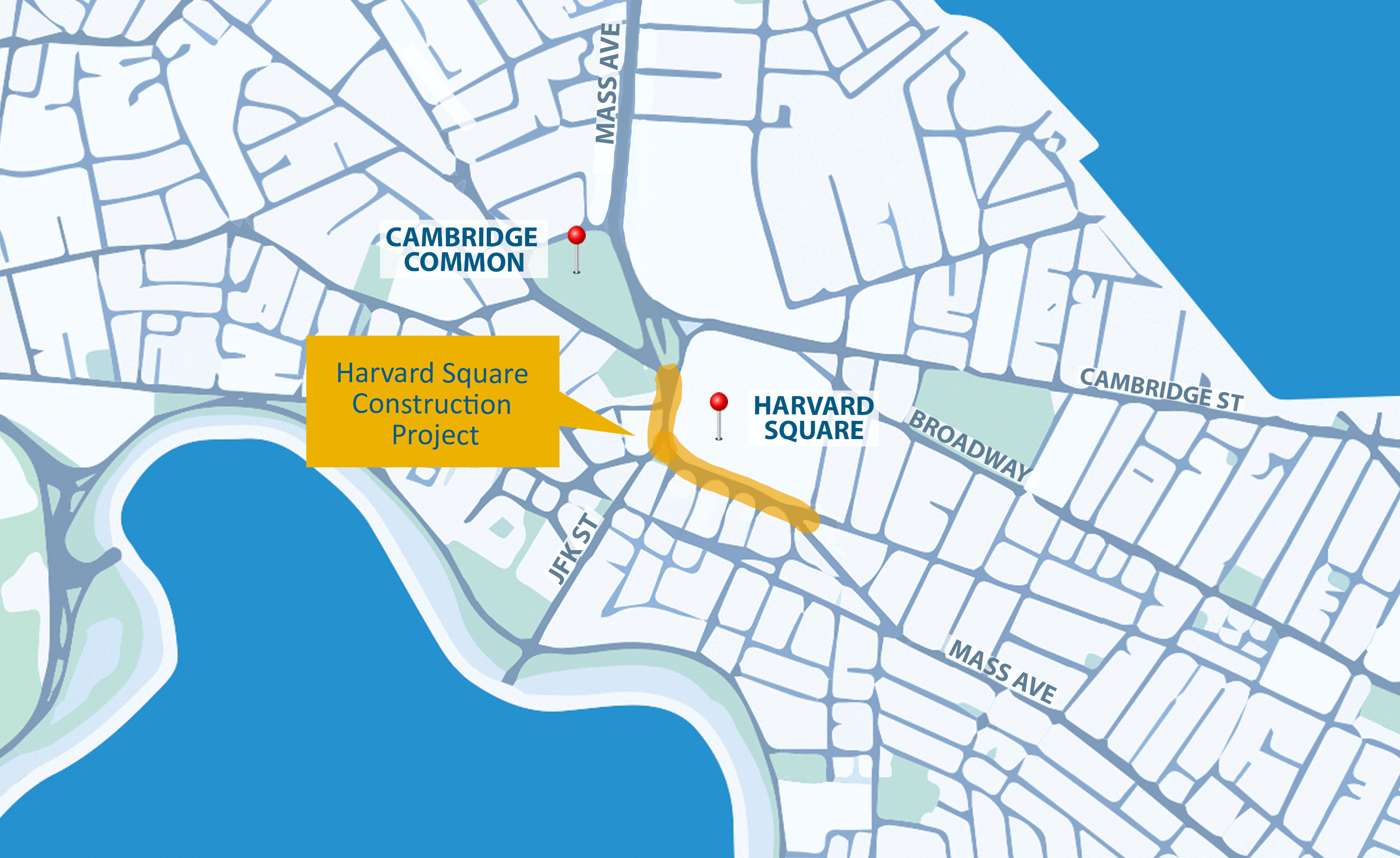
Harvard Square will be reconstructed as part of Cambridge’s Mass Ave reconstruction program:
 
That's good to see, though it doesn't go nearly far enough. Southbound from Garden all the way onto JFK, and northbound on JFK and Eliot, are major issues for the 66 and 86.
 
  • Columbus/Tremont, Malcolm X, Warren, and Blue Hill Avenue - so much of the Roxbury/Dorchester bus ridership is funneled through these corridors
Agreed on the value of all of these, but I've been staring at the lower half of Warren St (between Quincy St and Blue Hill Ave) for years now, trying to figure how to fit dedicated transit infrastructure into that space. Even if you delete all parking, it doesn't look like there is space for center-running boarding areas in addition to sidewalks, which points to side-running bus lanes instead, with bus stops directly on the sidewalk.

Maybe you could do something clever with one-way paired running on Warren and the northern section of Blue Hill (jumping between Warren and Blue Hill via Quincy St)?

  • BUMC/Boston Medical Center area
I've been looking at Albany St recently for this (in concert with lanes on Mass Ave). You would need to eliminate the parking, but that's probably an easier sell in a less-residential area. The street itself is 80 feet lot-to-lot, which gives you plenty of space to play around with different pieces of the puzzle. For example, see below, where I'm using offset platforms (e.g. flanking intersections) to avoid fitting two platforms into the same width of street:

1669660416653.png


(Careful observers will note that I did indeed fudge the width of the upbound bus lane, under the theory it can be slightly narrower when the bus is starting and stopping at the platform.)

(I'll also put my head into the lion's mouth and say that I personally believe it would be reasonable to prioritize bus lanes over bike lanes, if push comes to shove. But that's a larger discussion.)

At the northern end of Albany St, you can split into a one-way pair (northbound on Frontage Rd, southbound on Albany St), cut across the highway and eventually land at the South Station Access Road's crossing of Albany and Lincoln Sts. From there, you could run directly into the bus terminal, or you could run on surface streets to Dewey Sq (using some combination of single lanes on Surface Rd, Lincoln St, and/or Kneeland + Atlantic). At that point, you've reached the T7 subnetwork (Summer + the downtown lanes mentioned above) and you have lots of options for through-running.

Big picture, Albany St BRT provides a speedy path for south<>east circumferential service (e.g. Nubian to Airport). North of BUMC, half of the corridor's walkshed is the highway, and the other half is 2 blocks away from local service on Washington St, so you won't need as many stops. This contrasts with the two other alternatives: South Boston Haul Road, which serves BUMC poorly and offers bad connectivity to the Red Line; and D Street, which is narrower and would demand more intermediate stops. (The T12 via D St is a great idea, but should supplement rather than replace true circumferential service.)

At the same time, Albany St BRT can provide a speedy path between Downtown and BUMC, and potentially even further to Nubian. Big picture, Nubian-BUMC-Albany-South Station-Seaport-Airport is a circumferential service, but if you zoom in on South Station-BUMC it can provide a useful radial service.

tl;dr: Imagine Albany St BRT serving an extend SL3 that runs from Chelsea to Nubian via BUMC.
 
^ Regarding Albany configuration, what if you paired up Albany and Harrison as one-ways, with bus, bike, travel configurations? Would that make it easier, or is it to hard to have buses on parallel streets?
 
^ I think Albany and Harrison are a bit far apart for one-way bus running. Easy legible transit should have its "inbound" and "outbound" stops in what could be considered "the same location", and my gut reaction is that the block between Albany & Harrison is a bit too long for that.

I thought about tossing the bike lanes over to Harrison, but the upper part of Harrison is more residential, so I think it'd be harder to eliminate the parking if that were needed. Perhaps an in-between solution would be to have paired one-way bike lanes on both streets, and two-way bus lanes on Albany -- I think you could fit a single bike lane on Harrison without removing parking.

I'm wary of veering off topic and getting on my soapbox about cycling + bike lanes. One way or another, I think it's pretty likely a solution could be devised that would serve the needs of BRT and cyclists alike, and the particulars would just need to be worked out. And my overall point regardless is that I've increasingly come to see Albany St as a useful piece of the overall network -- certainly much more than it initially may appear.
 
(I'll also put my head into the lion's mouth and say that I personally believe it would be reasonable to prioritize bus lanes over bike lanes, if push comes to shove. But that's a larger discussion.)
You can avoid that dilemma by switching to a bi-directional cycle track on one side of the street. In your design, you've used 16 feet for bike infrastructure (6' lanes + 2' buffers done twice). A 12 foot bi-directional track plus buffer is 14 feet, yielding 2 more feet for bus purposes. You could even shave another 2 feet from that, by making the track only 10 feet wide, though you would start to get some significant pushback from bike activists at that width.
 
You can avoid that dilemma by switching to a bi-directional cycle track on one side of the street. In your design, you've used 16 feet for bike infrastructure (6' lanes + 2' buffers done twice). A 12 foot bi-directional track plus buffer is 14 feet, yielding 2 more feet for bus purposes. You could even shave another 2 feet from that, by making the track only 10 feet wide, though you would start to get some significant pushback from bike activists at that width.
Yeah good point, which goes back to my overall point -- the street is wide enough that, one way or another, I'm pretty sure we can fit bus + bike + car lanes.
 
With all this stuff about a redesigned bus network, I was wondering what people thought of as the next logical bus priority/BRT street? I think Mass Ave is probably the one that would make the most sense, but, now on the Mass Ave bridge, they just took out 1 lane to create bike lanes on the bridge. There's at least a short bus lane on the Boston side and ones going to the bridge on the Cambridge side. Maybe they can redo the bike lanes and create bus lanes too?

Malcolm X Blvd. Under the redesigned bus network, it will have the most frequent service of any street segment, by far. It is planned to have a minimum of 24 buses per hour from 6:00 am to 7:00 pm, 7 days a week. Not to mention that the boulevard is wide enough to easily accomodate Columbus-style center-running bus lanes. That should be the next choice.
 
On Albany St - I'd probably try to do center platforms for the bus. Would be interesting to have that and Washington St with Proper Silver Line center lanes if the corridor/area can support two BRT-eque build outs.
 
On Albany St - I'd probably try to do center platforms for the bus. Would be interesting to have that and Washington St with Proper Silver Line center lanes if the corridor/area can support two BRT-eque build outs.
Do you mean center platforms, or center lanes with side platforms? Sadly we can't do center platforms unless we buy new buses with left-hand doors. Now, I mean... if we get a robust network of center-running lanes across Greater Boston, it could be worth it to purchase a subfleet with left-hand doors, which honestly would be pretty cool.

Or we could do what LA does in certain places, and have buses crossover to use island platforms.

The BEB RFP has an option for 65 left-door buses in addition to the 35 for North Cambridge. They would presumably end up at Arborway, but for now don't have a clear use. It definitely seems like something they're open to/planning for. If they have to have a sub-fleet of left-door BEBs for the 71/73 (I think the need for this is debatable, but that's not what we're talking about here) they might as well expand the fleet.
I don't think Quincy has any need for left-door.
 
Last edited:
Do you mean center platforms, or center lanes with side platforms? Sadly we can't do center platforms unless we buy new buses with left-hand doors. Now, I mean... if we get a robust network of center-running lanes across Greater Boston, it could be worth it to purchase a subfleet with left-hand doors, which honestly would be pretty cool.

Or we could do what LA does in certain places, and have buses crossover to use island platforms.

Ah, yeah, totally forgot buses don't have doors on each side. That would certainly make center platforms pretty difficult.
 

Back
Top