I honestly kinda think it would've been more worthwhile going all-in on Leo M. Birmingham
instead of Soldiers Field Rd. But it's too late for this now:
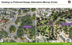
This whole bit is a mess for everyone involved
View attachment 62567
But what if Soldiers Field was reconfigured to more directly interface with Market St. with both directions of travel coming up to meet the intersection and only the Westbound continuing as a single lane under the underpass. Very rough MS paint drawings but hopefully gets the idea across. This would make it a single normal intersection with tad more queue space on Arsenal.
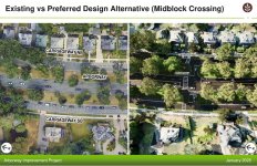
View attachment 62573
Then the intersection with Leo M. Birmingham and Market would be the main continuation of Soldiers Field. With Soldiers Field continuing as a normal 2-lane plus turning lanes street. This makes more sense to me since Soldiers Field Rd is the one that actually interfaces with businesses and the new apartments, whilst LMB is just a highway next to a highway. The off ramp from Soldiers East onto Market can remain and be either right turns only or another intersection. Traffic going to Soldiers Field West from Western Ave would need to take a left onto Market then right onto LMB to loop around or continue West whilst traffic from Arsenal would have basically the same connectivity to the road. This segment would then interface with the 2021 DCR proposal. This would return half of the current Soldiers Field Rd back to riverfront space and move the heavier traffic away from the new housing in the middle.
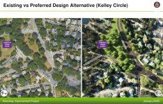
View attachment 62571
For those travelling from Nonantum onto Soldiers Field Rd today it'd add an additional 2 or 3 intersections depending on N. Beacon and Opposite Lothrop, but there would no longer be such a large queue of traffic needing to make the left onto Soldiers Field at the propsed new Parsons intersection allowing for it to be downsized with less turn lanes. Whilst there'd still be a queue to make a left onto Market St to continue onto Soldiers Field it'd have more space to do so on LMB where it'd be next to the Pike away from the residences, businesses, and the riverfront. As for going to Nonantum from Soldiers Field, that would remain unchanged but the hope is by reducing it to a single lane going west it'd both help better manage the subsequent left turn onto Nonantum as well as encourage more people and their GPS systems to go up to the right onto LMB to avoid any single lane queuing.
View attachment 62574
Anyway with the LMB lane removal underway this is pretty meaningless but it was fun to draw poorly in paint