You are using an out of date browser. It may not display this or other websites correctly.
You should upgrade or use an alternative browser.
You should upgrade or use an alternative browser.
Dedham Infill and Small Developments
- Thread starter FK4
- Start date
HenryAlan
Senior Member
- Joined
- Dec 15, 2009
- Messages
- 4,473
- Reaction score
- 5,256
And a 12/18 minute walk to bus/train. It's not great, and the render is pretty institutional, too.I mean, at least there is walkability to the mall... :/
And a 12/18 minute walk to bus/train.
Guess that's what the parking spots are for.
(This is where I mention that the cheapest unit available between the two complexes that is closer to Dedham Corp Center is pushing $2800, although there are a couple 2 bedrooms for "only" a couple hundred more. Figure if this is built, they will be asking more)
0.8 miles to Dedham Corporate. 0.5 mile walk to Star Market. An even shorter walk to a super market (Whole Foods) and other retail. Compared to what other towns have within a mile or so of their commuter rail stations, this is a pretty good project.
stick n move
Superstar
- Joined
- Oct 14, 2009
- Messages
- 13,482
- Reaction score
- 24,531
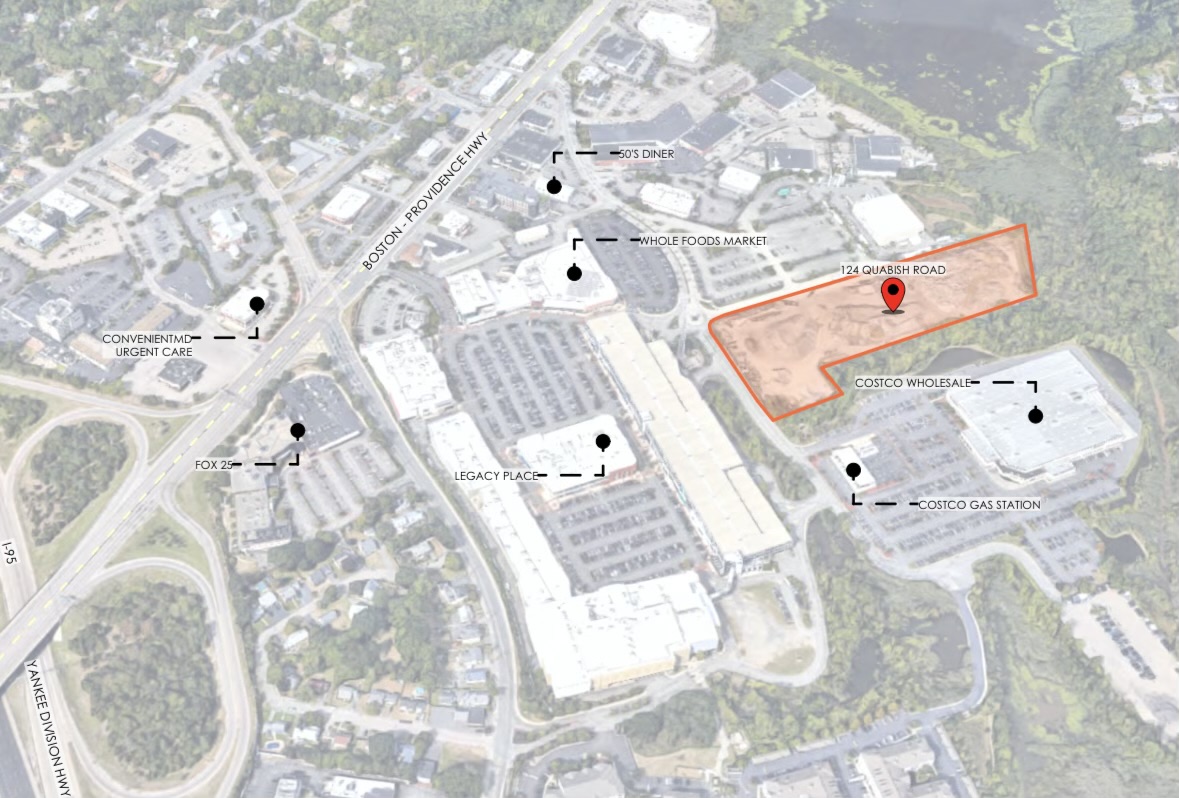
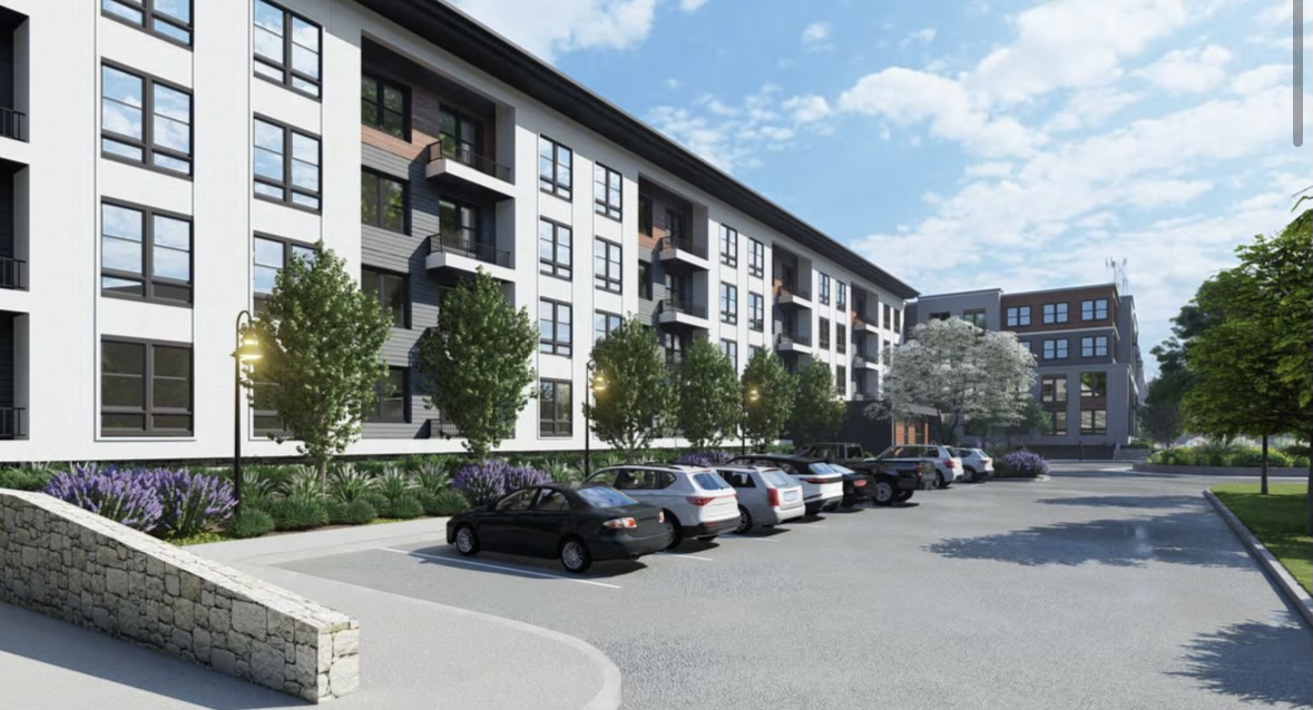
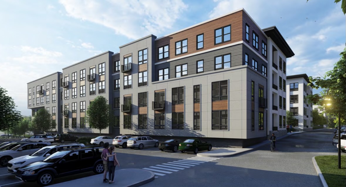
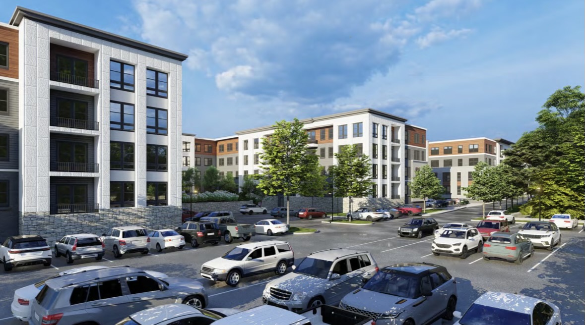
124 Quabish
“The Avenue is a proposed Mixed-Use Development consisting of three separate buildings with ~440,000 gross square feet of total floor area. It contains ~22,000 gross square feet of first-floor retail space and 293 residential apartment units.The residents will enjoy some awesome amenities such as a pool, bocce court, putting green, golf simulator, fitness room, yoga room, co-working space, lounge with café, top-floor clubroom with a sports lounge, kitchen area and roof deck, car-washing station, an on-site dog-run, dog-wash rooms, community vegetable garden, and secured indoor bike storage. This project is located in Dedham, MA and is just a stone’s throw away from the popular shopping and dining destination, Legacy Place and Dedham Corporate Center Train Station.”
https://embarcdesign.com/project/124-quabish/#forward
stick n move
Superstar
- Joined
- Oct 14, 2009
- Messages
- 13,482
- Reaction score
- 24,531
Early Stage Plans Presented for Mixed-Use Tech Campus on 57-Acre Site in Dedham
“Early-stage plans have been presented for the development of a 57-acre site at the intersection of Routes 128/135 in Dedham. The team is aiming to create a Tough Tech campus offering a setting for users to live, work, play & sleep. Two different development scenarios were shown, the first offering 400K SF lab space, 470K SF R&D, and 644 residential units. The second option would retain the same unit count and lab square footage but cut 100K SF from the R&D space in favor of a hotel.”

Early Stage Plans Presented for Mixed-Use Tech Campus on 57-Acre Site in Dedham
Early Stage Plans Presented for Mixed-Use Tech Campus on 57-Acre Site in Dedham
 www.bldup.com
AndrewOnTheMBTA
Active Member
- Joined
- Mar 12, 2021
- Messages
- 355
- Reaction score
- 776
This is great. On a grander scale, about Dedham, does anyone have insight about how and why Dedham is so underdeveloped for a town so close to Boston? I imagine lots of nimbyism for sure, amongst infrastructure being poorly connected, not a great highway connection, and lots of single family housing? It only has like 26k people IIRC.
greenbeans
New member
- Joined
- Dec 15, 2021
- Messages
- 41
- Reaction score
- 63
The amount of money that lives on the street on right side of the render gives me pause that this will ever come close to what's being shown.
I’m amazed there was no thread for Dedham until I started this one in 2022, and I’m amazed at how little activity it’s had in the last three years. Sure says a lot about the town’s restrictive and anti-development policies, I guess.Surprised that there isn’t a thread for Dedham. I don’t have pics but saw two different large-appearing projects on Washington, near the Dedham-Boston line. Figured I’d mention.
Also hilarious how the render shows Wigwam Pond as a crystal blue river but the aerial shows it to be a duckweed-filled near-swamp.75-125 Stergis Way


150+ Unit Multifamily Proposed Near Legacy Place in Dedham
“Norblom Company is planning a 4-story multifamily building at 75-125 Stergis Way adjacent to Legacy Place. The developer would demolish the existing commercial buildings on the site and construct a new development to include 154 apartments with 241 off-street parking spaces. Units would be primarily a mix of 1 & 2 bedrooms with 23 units designated affordable.”
https://www.bldup.com/posts/150-unit-multifamily-proposed-near-legacy-place-in-dedham
Judging by the render it appears to be this building and the similar one diagonally down from it and to the left.
View attachment 49854
JumboBuc
Senior Member
- Joined
- Jun 26, 2013
- Messages
- 2,808
- Reaction score
- 1,994
What the hell is going on here:

That's wider than many of the highest-trafficked sections of 90, 93, and 95.
And it doesn't even include the frontage road (parallel to the east) that actually serves all the businesses along that stretch. And this design limits your ability to take a left out of any of these businesses (or turn into them when traveling southbound) resulting in extra driving and extra U-turns.
This is essentially a super-highway connecting two congested intersections a mile and a half apart. If there's a section of road more in need of diet anywhere in greater Boston, I can't think of it.
Last edited:
a light so that you can bang a u-ey to get to popeyes fasterWhat the hell is going on here:
View attachment 71431
That's wider than many of the highest-trafficked sections of 90, 93, and 95.
And it doesn't even include the frontage road (parallel to the east) that actually serves all the businesses along that stretch. And this design limits your ability to take a left out of any of these businesses (or turn into them when traveling southbound) resulting in extra driving and extra U-turns.
This is essentially a super-highway connecting two congested intersections a mile and a half apart. If there's a section of road more in need of diet anywhere in greater Boston, I can't think of it.
Chickenman
New member
- Joined
- Jul 17, 2022
- Messages
- 49
- Reaction score
- 146
Hey! I've also used it to get home from pet supplies plus faster.a light so that you can bang a u-ey to get to popeyes faster
That aside, the need for this u-ey is only present because it's a 4 lane separated highway, this thing could easily be knocked down to a 2 lane regular road and be just fine capacity wise.
The density is weird here, you've got a big new apartment development to the north of the original picture up there right next to Boston's only trailer park, but also a bevy of auto centric drive throughs and plazas. Plus you can see one side of this is just Charles River marshland, that's never going to densify. I'm really not convinced this would be the best use of resources for a road diet, surely there's roads with bigger upside for a diet than this one.
JumboBuc
Senior Member
- Joined
- Jun 26, 2013
- Messages
- 2,808
- Reaction score
- 1,994
Nah - if you want a light to bang a u-ey you can just... add a light to bang a u-ey. You don't need to add a light plus four full on jughandle lanes, all separated by enormous asphalt medians.a light so that you can bang a u-ey to get to popeyes faster
See for example just a little bit south of this on a much more developed section of the same road in Dedham where you have the same stop light u-turn functionality in less than half of the roadway width. And this standard four-way-stop-with-turning lanes intersection is even more functional because it serves four directions rather than 2. Note that the monster jughandle thing in my first post doesn't even provide access to the frontage road, so if you're trying to get in or out of that car wash or storage facility or Ocean State Job Lot to the east you're SOL.
The Boston portion of this road north of this has straight up u-ey sections without lights that also require way less space, and that's with a proper parkway tree-lined median.
There's a clear divide here (note the dotted red line in my first post) exactly at the Boston - Dedham border. The VFW Parkway section in Boston is FAR from perfect, but when you cross the line into Dedham it gets 100 times worse. In Boston you can directly pull in and out of the newer apartment building, car dealers, pet supplies plus, etc.. In Dedham the superhighway only serves through traffic, and the businesses are served by a separate frontage road with only a few limited connections to the main road.Hey! I've also used it to get home from pet supplies plus faster.
That aside, the need for this u-ey is only present because it's a 4 lane separated highway, this thing could easily be knocked down to a 2 lane regular road and be just fine capacity wise.
The density is weird here, you've got a big new apartment development to the north of the original picture up there right next to Boston's only trailer park, but also a bevy of auto centric drive throughs and plazas. Plus you can see one side of this is just Charles River marshland, that's never going to densify. I'm really not convinced this would be the best use of resources for a road diet, surely there's roads with bigger upside for a diet than this one.
Boston also has development on the west side while Dedham does not, and marshland can't explain it unless that follows municipal boundaries exactly.
The Dedham portion literally has sections with wider asphalt than runway 14/32 at Logan.
Last edited:
palindrome
Senior Member
- Joined
- Jun 11, 2006
- Messages
- 2,287
- Reaction score
- 138
I love when I can time it perfectly so I can use the turn lane as a bypass to the red light there.
Chickenman
New member
- Joined
- Jul 17, 2022
- Messages
- 49
- Reaction score
- 146
Sure? I'm not saying any of it is good. Maybe Boston drained some wetlands back in the day for development, but there's no way you could really do that now on the Dedham side from an environmental standpoint so it doesn't really matter. I'm just saying that yeah, this is a pretty bad case of car sewer, but there's better opportunities for road diet/redesign than this (Rutherford Ave, etc).There's a clear divide here (note the dotted red line in my first post) exactly at the Boston - Dedham border. The VFW Parkway section in Boston is FAR from perfect, but when you cross the line into Dedham it gets 100 times worse. In Boston you can directly pull in and out of the newer apartment building, car dealers, pet supplies plus, etc.. In Dedham the superhighway only serves through traffic, and the businesses are served by a separate frontage road with only a few limited connections to the main road.
Boston also has development on the west side while Dedham does not, and marshland can't explain it unless that follows municipal boundaries exactly.
The Dedham portion literally has sections with wider asphalt than runway 14/32 at Logan.
Ah yes, love it when I can't get to the u-ey because there's a stream of cars bypassing the light and I have to wait for the next one. You know what, I take it back, road diet this shit yesterday.I love when I can time it perfectly so I can use the turn lane as a bypass to the red light there.
stevebikes
Active Member
- Joined
- May 14, 2013
- Messages
- 307
- Reaction score
- 216
a light so that you can bang a u-ey to get to popeyes faster
I grew up over here. Back then you'd do it to get to the good McDonald's on the east side (across from the smaller one on the west side).
I love when I can time it perfectly so I can use the turn lane as a bypass to the red light there.
One of my first learned driving skills.
stick n move
Superstar
- Joined
- Oct 14, 2009
- Messages
- 13,482
- Reaction score
- 24,531
Gateway Mixed-Use Development at 2 Bridge Street
Caption (Top and Bottom): Renderings of the new mixed-use development in Dedham, provided by the property owners 2-4 Bridge Street LLC.
“In February 2026, the Planning Board approved a new, four-story mixed-use redevelopment at 2 Bridge Street at the existing Waterford’s restaurant property. The project, located at the West Roxbury (Boston)/Dedham line and on the Charles River, will include 26 condominium units and a 60-seat restaurant. When complete, the project is expected to provide an estimated $50,000 in additional annual property tax revenue to the Town, along with additional restaurant meal taxes.”
Redevelopment of 25 Allied Drive into Mixed-Use Development
Caption: Rendering of the new mixed-use development in Dedham, provided by ZDA Architecture & Interior Design.
“In March 2026, the Planning Board approved the redevelopment of 25 Allied Drive, converting an existing 267-room Hilton hotel into a 160-unit mixed-use residential development. The property is also home to 107,724 sq. ft. of existing office space, which will remain. The approved project includes a mix of unit types (15% (21 units) will be designated as affordable units) and is expected to significantly increase the property’s assessed value (from approximately $13 million to over $42 million) resulting in an estimated $200,000 in additional annual property tax revenue to the Town, along with substantial one-time permitting fees.
The development will also construct a new sidewalk and crosswalk on Allied Drive to better connect pedestrians to the nearby MBTA Dedham Corporate Center Commuter Rail Station.”
stick n move
Superstar
- Joined
- Oct 14, 2009
- Messages
- 13,482
- Reaction score
- 24,531
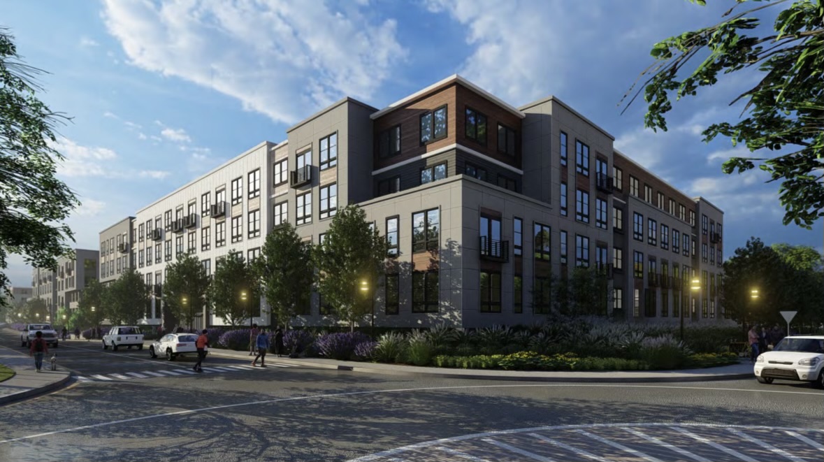
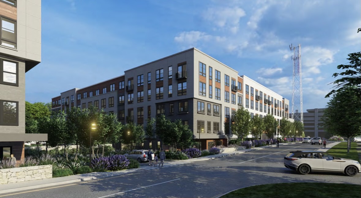
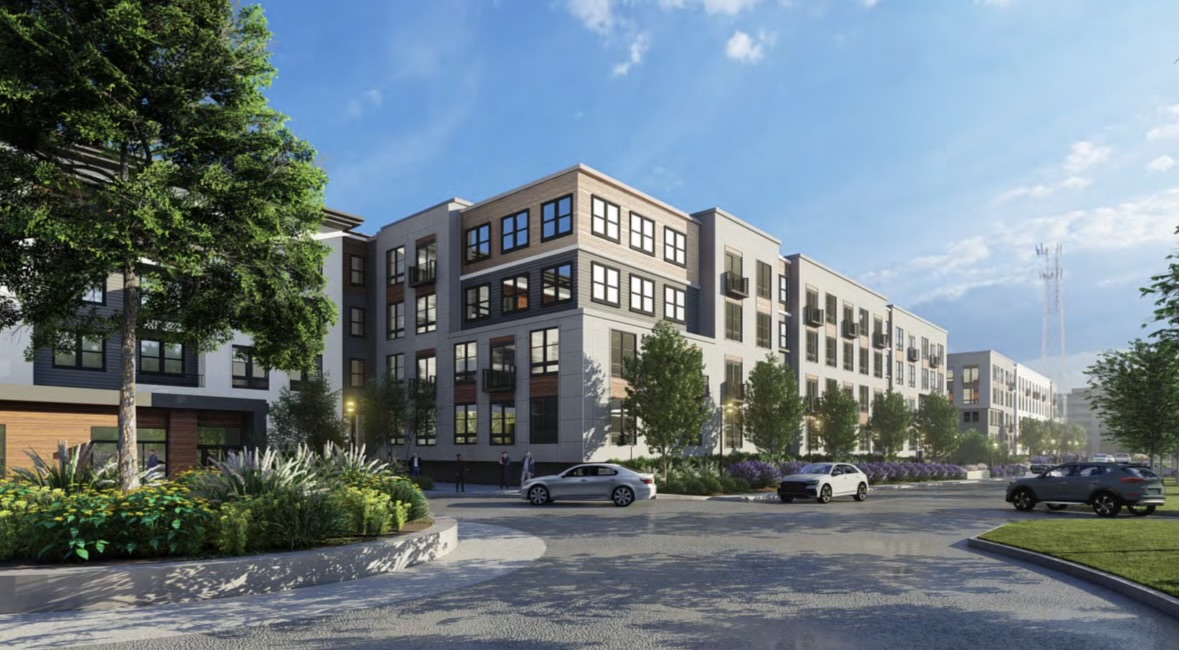
124 Quabish rd.
“We had a major project approved last week! This is a 380 unit residential development in Dedham. The project is being developed under the State’s MBTA housing initiative. Dedham was one of the first towns to vote in the MBTA housing and this project is one of the largest in the state. Excited to get started! Stay tuned for updates”


Facebook
 www.facebook.com
 www.dropbox.com
“We had a major project approved last week! This is a 380 unit residential development in Dedham. The project is being developed under the State’s MBTA housing initiative. Dedham was one of the first towns to vote in the MBTA housing and this project is one of the largest in the state. Excited to get started! Stay tuned for updates”
www.facebook.com
Dropbox
www.dropbox.com
Last edited: