Assembly Sq <-> Casino Footbridge

A
MassDOT is likely to approve the construction contract for this bridge on Wednesday at its scheduled board meeting, as it emerged from capital committee a couple weeks ago with a positive recommendation despite the cost delta from engineering estimate - attributed to cost of steel & apparently none of the contractors wanted to build "land out" and drive through & stage in the (renovated) draw 7 and encore - apparently this is going to be a largely barge based build.View attachment 75794
View attachment 75793

Awesome that they're actually going to build this.
 
MassDOT is likely to approve the construction contract for this bridge on Wednesday at its scheduled board meeting, as it emerged from capital committee a couple weeks ago with a positive recommendation despite the cost delta from engineering estimate - attributed to cost of steel & apparently none of the contractors wanted to build "land out" and drive through & stage in the (renovated) draw 7 and encore - apparently this is going to be a largely barge based build.View attachment 75794
View attachment 75793
Glad it's moving forward, but that is an expensive bridge.

We don't normally spend that kind of money on non-car infrastructure. Can anyone think of any similarly expensive pedestrian infrastructure?
 
Glad it's moving forward, but that is an expensive bridge.

We don't normally spend that kind of money on non-car infrastructure. Can anyone think of any similarly expensive pedestrian infrastructure?
Original estimates for the Somerville Community Path along GLX were reaching those numbers. Then it got value engineered.

The Stepping Stones Bridge/Island Project for crossing the Charles at the MOS is currently estimated at $302 Million! (Early planning stages).
 
Glad it's moving forward, but that is an expensive bridge.

We don't normally spend that kind of money on non-car infrastructure. Can anyone think of any similarly expensive pedestrian infrastructure?
We (the US) spend a lot on non-car infrastructure, like pipelines, and even non-car transportation infrastructure, especially rail, aviation, and water-transpotation infrastructure. Not uncommon for those tyes of projects well into the billions of dollars.

Fun fact: at $600M, the Silver Line (Waterfront / South Boston Piers Transitway) is arguably the most expensive bus-only infrastructure project in the US.

The High Line cost $150M (in 2010s dollars). The 606 cost about $100M (also in 2010s dollars). I'm not sure of any other bike/ped infrastructure this expensive.
 
$95 mn for a very architectural pedestrian and bicyclist bridge?

I walked this bridge in Portland Oregon last year - it was about $20 mn in 2019 dollars. Google Maps says this is about 1/3rd the distance spanned - so that cost doesn't seem outlandish - given ~30% general inflation from 2019 to 2026.
 

<snipped from the article>

The long-planned and eagerly awaited bike and pedestrian bridge across the Mystic River between Everett and Somerville is now moving forward again, after fits and starts.

The Massachusetts Department of Transportation this week announced it has approved a $78.7 million contract to begin the work of designing and building the roughly 800-foot-long bridge, which would be one of the largest of its kind in the Boston area.

When finished, the bridge would run between Somerville’s Assembly Row and the boardwalk of the Encore casino in Everett. It would provide a link to the Northern Strand Community Trail path, which runs all the way to Lynn, a short distance from Nahant Beach. It is also intended to be how thousands of soccer fans will cross the river on the way to the soccer stadium the Kraft Group has proposed nearby.

“Executing this contract brings us another step closer to delivering a safer, multimodal transportation network connecting residents and communities of Everett, Somerville and the entire region,” said Phil Eng, the state’s interim secretary of transportation and MBTA general manager, in a statement.

<>

1790437438429.png
 
My understanding is the bridge will anchor on Encore's casino property so soccer fans would need to navigate through the Encore riverwalk, cross rt 99 to to get to the Dexter St entrance. Whether that makes this a longer commute than commuting (walking) from the Sullivan T stop is up for debate.
 
Last edited:
I still do not understand this idea - Sullivan will ultimately be closer than any potential link from Assembly. Are the stadium operators planning to use the MGB/Partners garage for events?
From the stadium thread:

The pedestrian-friendly (0 street crossings including the alford st underpass) Assembly to bridge to stadium route is 1.04 miles and about 15-20 minutes. On the other hand, the article mentions "a total of $13 million for community mitigation payments over time in Boston that will include infrastructure improvements in the Sullivan Square section of Charlestown" (which I hope is the Rutherford Avenue/ Sullivan Square Safety Project, along with the Ryan Playground proposed extension). This will, and will always be, less pedestrian-friendly (a minimum of 4 street crossings with significant traffic and tighter sidewalks) than the Assembly bridge. However, it will be shorter at 0.7 miles and around 12-17 minutes. There are a lot of pedestrian improvements and it's difficult to say which would be preferable between the two routes once the options are presented. Assembly+ Bridge certainly provides more amenities at this point in time, but Sullivan should be quicker and will likely improve quite fast if the city can incentivize development on some of the parking lot parcels in the coming years.
...
15-20 minute walk to transit works fine for many transit-oriented soccer stadiums around the US/world, and I suspect the Silver Line Extension + Frequent 109 (+ less frequent 113) buses completely on separated bus lanes will be a well-used option as well for those who are willing to pack in for 3 stops or so. If/ when this all gets built I'm very excited and curious to see what routes come out on top

14590.png

14591.png
14589.png


It's also likely that many fans will arrive early to Assembly and get food/drinks/activities before and after the game. Sullivan/encore/gateway doesn't currently offer this, so the bridge creates a very strong link between Assembly businesses and gameday. Assembly is also 1 of 4 separate zones for parking in the preliminary parking plans, so i think it's a safe bet that a decent amount of fans will be parking there and taking the bridge.
 
From the stadium thread:

The pedestrian-friendly (0 street crossings including the alford st underpass) Assembly to bridge to stadium route is 1.04 miles and about 15-20 minutes. On the other hand, the article mentions "a total of $13 million for community mitigation payments over time in Boston that will include infrastructure improvements in the Sullivan Square section of Charlestown" (which I hope is the Rutherford Avenue/ Sullivan Square Safety Project, along with the Ryan Playground proposed extension). This will, and will always be, less pedestrian-friendly (a minimum of 4 street crossings with significant traffic and tighter sidewalks) than the Assembly bridge. However, it will be shorter at 0.7 miles and around 12-17 minutes. There are a lot of pedestrian improvements and it's difficult to say which would be preferable between the two routes once the options are presented. Assembly+ Bridge certainly provides more amenities at this point in time, but Sullivan should be quicker and will likely improve quite fast if the city can incentivize development on some of the parking lot parcels in the coming years.
...
15-20 minute walk to transit works fine for many transit-oriented soccer stadiums around the US/world, and I suspect the Silver Line Extension + Frequent 109 (+ less frequent 113) buses completely on separated bus lanes will be a well-used option as well for those who are willing to pack in for 3 stops or so. If/ when this all gets built I'm very excited and curious to see what routes come out on top


It's also likely that many fans will arrive early to Assembly and get food/drinks/activities before and after the game. Sullivan/encore/gateway doesn't currently offer this, so the bridge creates a very strong link between Assembly businesses and gameday. Assembly is also 1 of 4 separate zones for parking in the preliminary parking plans, so i think it's a safe bet that a decent amount of fans will be parking there and taking the bridge.
Coming from Assembly, especially without having to cross Alford would be way more pleasant than Sullivan, but the distances are misleading. The headhouse at Assembly doesn't have a draw seven exit (yet) so you have to walk from the station all the way to the yacht club and back to get to the bridge. However, permeability between Assembly and Draw Seven def should be improved and having the only access points be the yacht club and through the T stop is not great.
 
Coming from Assembly, especially without having to cross Alford would be way more pleasant than Sullivan, but the distances are misleading. The headhouse at Assembly doesn't have a draw seven exit (yet) so you have to walk from the station all the way to the yacht club and back to get to the bridge. However, permeability between Assembly and Draw Seven def should be improved and having the only access points be the yacht club and through the T stop is not great.
Kraft has put forward $17.5 million for the headhouse as part of the Everett community agreement, and the completion of the headhouse is tied to the bridge/stadium opening.
$17.5 million is dedicated to the construction of the headhouse at Assembly Row to provide Everett residents and visitors expanded access to public transportation and the Orange Line. If construction of both the headhouse and the Mystic River Pedestrian Bridge Project currently underway at MassDOT does not commence within three years of the stadium opening, the funding obligation will sunset and the City of Everett will receive $15 million directly.
We're talking 3-4 years until anything is ready and everything is in place. Stadium won't open until 2030 at earliest and the pedestrian bridge will be done by Fall 2029 earliest. I think it's pretty sure that if we have the stadium and the bridge, then we'll have the headhouse at least within a year or two.
 
Given the lack of local parking, if any, public transportation via the T or the Bus line will be critical to get people to the soccer stadium but I can't imagine how crazy it will be trying to get on a train at Assembly or Sullivan after a sellout game. I suspect they'll need to run additional trains to accommodate the crowds?
 
Last edited:
Given the lack of local parking, if any, public transportation via the T or the Bus line will be critical to get people to the soccer stadium but I can't imagine how crazy it will be trying to get on a train at Assembly or Sullivan after a sellout game. I suspect they'll need to run additional trains to accommodate the crowds?
Sure, both stations will be crowded after the game, but it's less of a challenge than Kenmore and Fenway after a Sox game. Crush load for an Orange Line train is 1,344. If the stadium capacity is 25,000, and every single fan uses the Orange Line, a total of 19 trains will be required to clear the crowd. At a train every 4.5 minutes in each direction, it would take 45 minutes total to move everybody out of the area. But some people will be on buses, some people will use ride share, some people will drive and park (no new parking with the development, but there is currently plenty of parking at other nearby locations), and some will hang out at Assembly Row for a few hours afterward. If we can't clear the crowd from a stadium that is a short walk from a heavy rail line, then what are we even doing?
 
Sure, both stations will be crowded after the game, but it's less of a challenge than Kenmore and Fenway after a Sox game. Crush load for an Orange Line train is 1,344. If the stadium capacity is 25,000, and every single fan uses the Orange Line, a total of 19 trains will be required to clear the crowd. At a train every 4.5 minutes in each direction, it would take 45 minutes total to move everybody out of the area. But some people will be on buses, some people will use ride share, some people will drive and park (no new parking with the development, but there is currently plenty of parking at other nearby locations), and some will hang out at Assembly Row for a few hours afterward. If we can't clear the crowd from a stadium that is a short walk from a heavy rail line, then what are we even doing?
And if the T is smart, they will plan for surge capacity around game times. The Wellington Yards are right nearby, so that would be easy to accomplish. The T could also execute a "skip stop" strategy, where trains around game time either stop at Sullivan or Assembly, but not both (clearly marked). That way crush loads at one stop don't cause zero boarding at the next. (Otherwise inbound trains would always be severely disadvantaged at Sullivan after games.)

The T even does that for Kenmore, and there are not even any real yards nearby, just minor storage track.
 
Last edited:
Sure, both stations will be crowded after the game, but it's less of a challenge than Kenmore and Fenway after a Sox game. Crush load for an Orange Line train is 1,344. If the stadium capacity is 25,000, and every single fan uses the Orange Line, a total of 19 trains will be required to clear the crowd. At a train every 4.5 minutes in each direction, it would take 45 minutes total to move everybody out of the area. But some people will be on buses, some people will use ride share, some people will drive and park (no new parking with the development, but there is currently plenty of parking at other nearby locations), and some will hang out at Assembly Row for a few hours afterward. If we can't clear the crowd from a stadium that is a short walk from a heavy rail line, then what are we even doing?
I generally agree with you here, but it probably isn't accurate to count the capacity of trains going both directions. I'd guess there will be far more people going south, while the northbound trains will be much emptier. So clearing all those people would take quite a bit longer than 45 minutes. No idea how big a difference that will make, what with all the other travel options you listed.

Wasn't the Kraft Group supposed to work with Boston and MBTA to come up with an actual, specific transportation plan? I'm blanking, did that ever happen? Was it made public?
There is a transportation plan in the works but it's very rough now, they had a presentation last week for the MEPA with the first pieces of info. They're anticipating ~30% taking transit so about 7500 riders, but they'll have to prepare for potentially much more. Depending on the quality of the bridge walk, Sullivan Square improvements, and shifting the fan base towards more transit-inclined demographics it might become quite popular. The existing fanbase is very suburban and car-dependent, but that could change rapidly with the more urban/transit-accessible location.
2026-09-17_MEPA_DEIR_Pre-Filing_Meeting_p5q93q_page-0043.jpg
2026-09-17_MEPA_DEIR_Pre-Filing_Meeting_p5q93q_page-0044.jpg
2026-09-17_MEPA_DEIR_Pre-Filing_Meeting_p5q93q_page-0046.jpg
2026-09-17_MEPA_DEIR_Pre-Filing_Meeting_p5q93q_page-0047.jpg
2026-09-17_MEPA_DEIR_Pre-Filing_Meeting_p5q93q_page-0050.jpg
2026-09-17_MEPA_DEIR_Pre-Filing_Meeting_p5q93q_page-0051.jpg
 
Last edited:
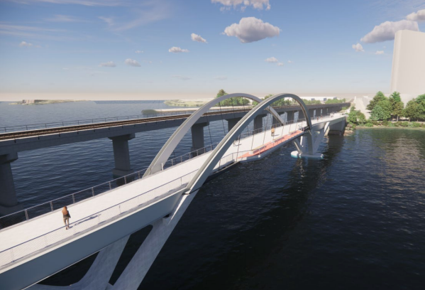
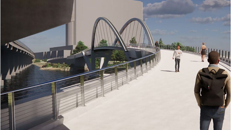
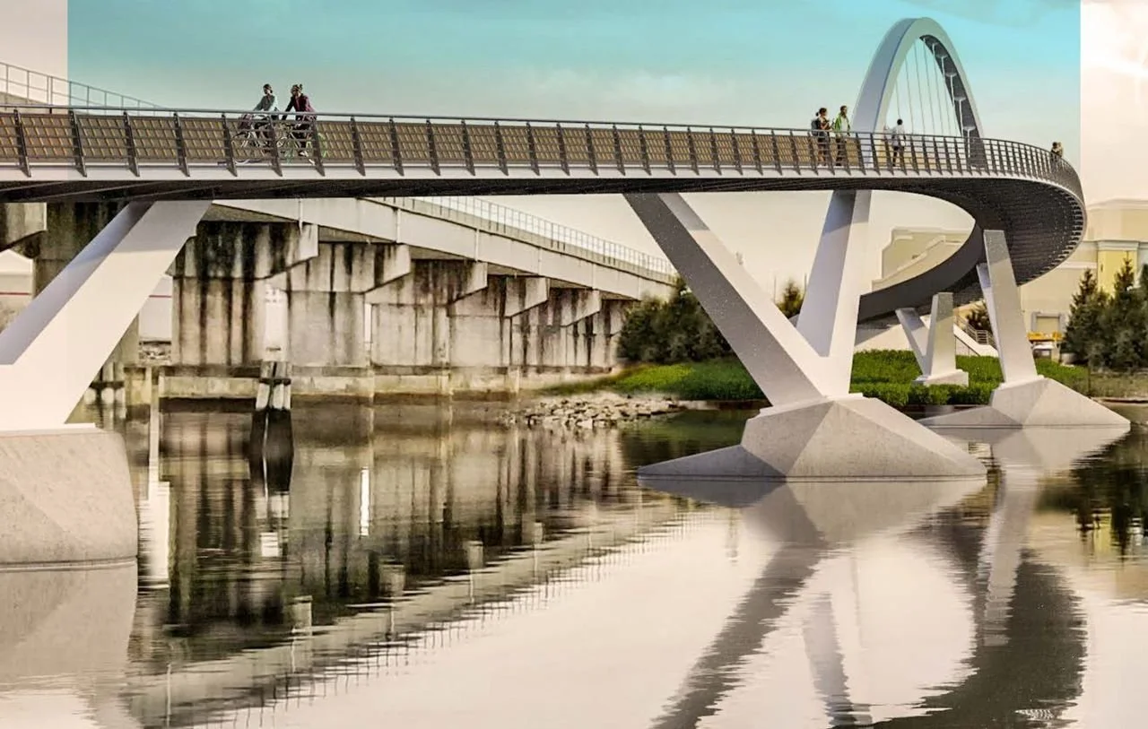
Some new renders

Looks like its changed again. Its now kind of a cross between the previous 2 versions. The arches are angled out to each side again and the bracing between them has been removed. It now looks like the first version again, but mirrored and then the 2 halves put together. The second iteration was more of a normal tied arch bridge set on top of the concrete piers, the new version is more of a through arch which is similar to how the first version was, only it was one sided so a side arch. Nice to see it has a viewing platform now too on the side facing the downtown skyline.
Screenshot-2026-09-30-at-11.31.22-AM-6abd2b5c979c6.png

Mystic-River-pedestrian-bridge-rendering-6abd178b6d237-768x432.jpg

Link


First iteration
Pedestrian+Bridge.jpg

1790800456793.jpeg

Link


Second iteration
MassDOT-Mystic-Bridge-night-rendering-2025.jpg

IMG_6520.jpeg

Link


Last edited:
Any word on the Assembly headhouse extension? It's required to start construction within 3 years of the stadium opening in order to get Kraft's money, and the walking distance to the station is ~1,800 feet longer without it.
 

Back
Top