boston roads

stick n move

Superstar
Joined
Oct 14, 2009
Messages
11,238
Reaction score
15,514
a method to the madness

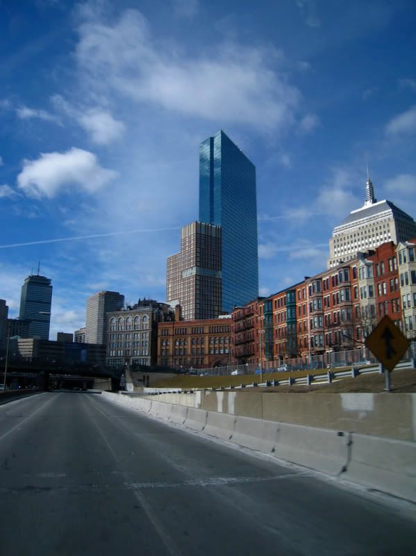
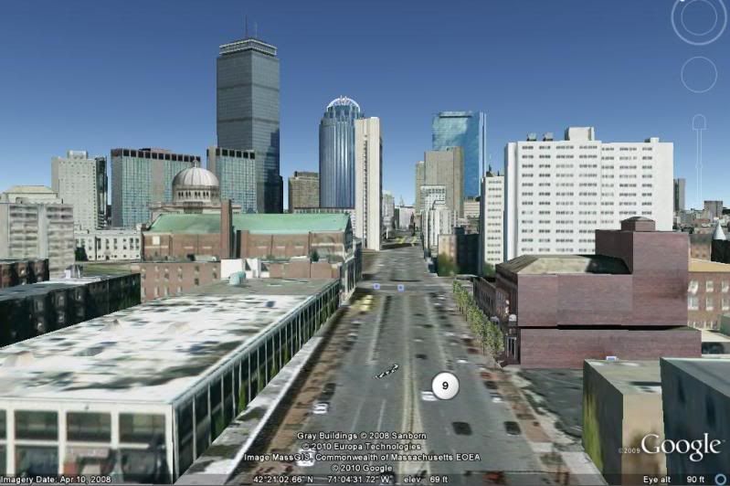
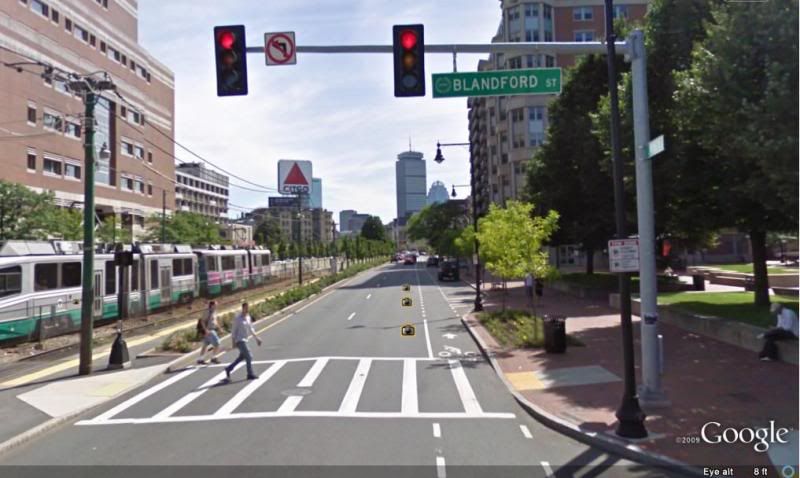
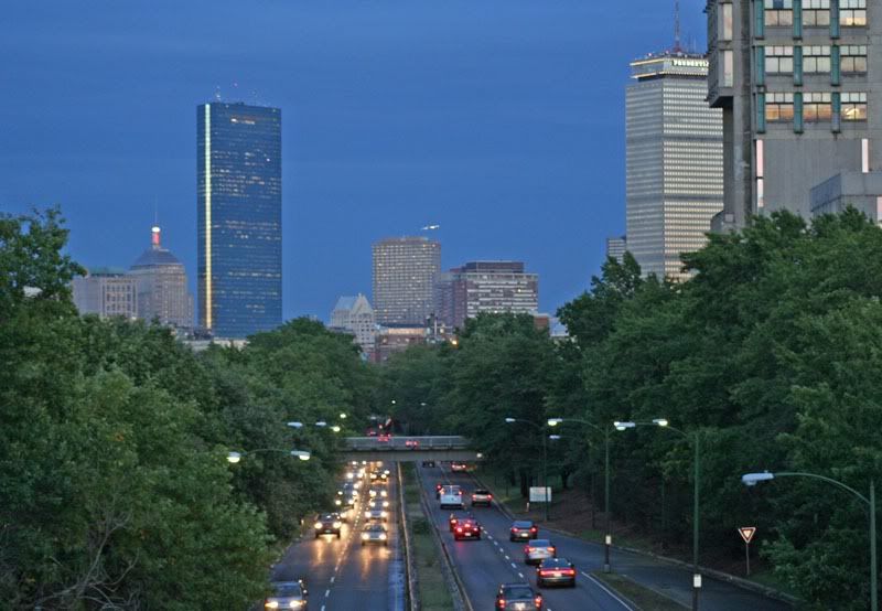
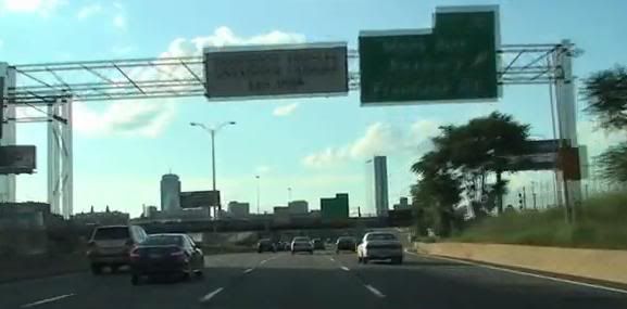
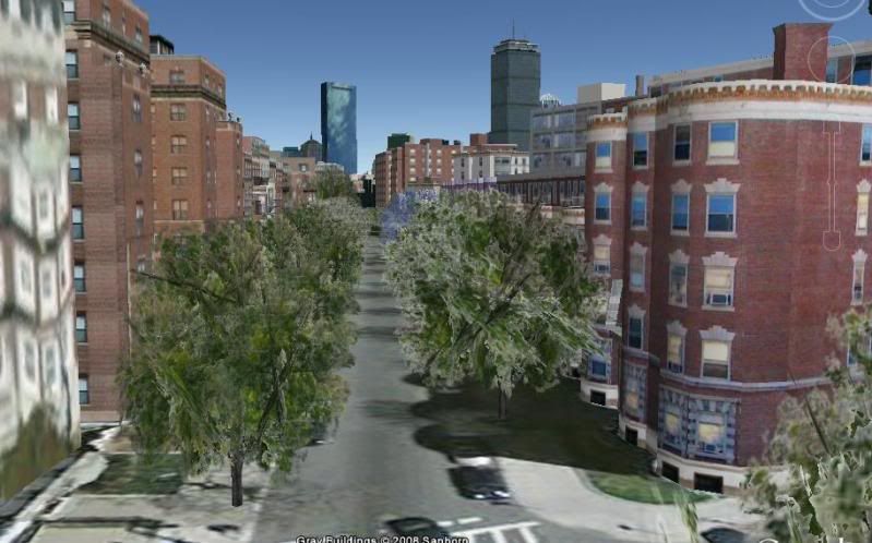
Boston gets a bad rap for its roads but theres something hidden behind all of the madness, well some of it. Some how some way all of the highways in boston and a lot of smaller roads in the back bay point directly between the hancock and prudential. I mean directly in the middle with one tower on one side of the road and one on the other. Its amazing how roads that were laid down at random and made for horses can have this effect. I havent seen something like this is any other city. Dont take my word for it heres some pictures to show what I mean.

Note: Theres a lot more roads that do this than I am showing, also these arent my pictures their used to express my point.


Storrow drive
50015025StorrowDrive.jpg


The familiar mass pike view
P1240383.JPG


The other way on the pike
4359888165_4b429e45cf_b.jpg


I-93 coming from the south (this is the most side on view)
i-93intoboston.jpg


Route 9
goog.jpg


Commonwealth Ave
commonwealthave2.jpg


Beacon St (only seen on foot one way street other direction)
beaconst.jpg
 
Last edited:
this being COINCIDENSE? Iam thinkin NOT!!! Liking the CROP CIRCLES. Sclaes is droping from these eyes here. the ALIENS cosmonautology? Masonite INFLUENZA? this interesting ones. Iam hopping for some splanations here. MAYBE this GOOD for TOURISTISM. get the SPOOKSYmovies maid here too!!! Seeing Tom hanks and TOM CRUZE and albinosman.

seeing BIG OPORTUNATIES WITH THIS POST!!!
 
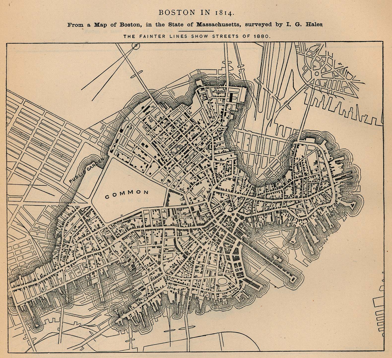
Interesting observation. My understanding of this is that it's because of how Boston developed in the late 1700's into early 1800's with the addition of the Back Bay master plan. It also has to do with Boston's original shape as a peninsula and the one main road out of the city. It's nice though how the Prudential and Hancock towers can be viewed like this around the city. The only view that doesn't achieve this effect is probably from the north (Tobin Br. and Route 99 through Charleston and Chelsea).

boston_1814.jpg
 
yea it is really an awesome coincidence that allows the city to be very unique
 
yea it is really an awesome coincidence that allows the city to be very unique

It certainly is unique and I think it gives Boston some character. That and it allows neighborhoods to feel different from others.
 
Occasionally roads open up views toward the city's tallest buildings. This is unprecedented! Only in Boston!
 
Yeah I was going to say...I think this might just be coincidence. It just so happens in Boston to be organic, whereas in other cities they're planned to have these views. Much more predictable; Boston is more reminiscent of a Japanese tea garden, a surprising vista around every rock (building) formation.
 
Yeah I was going to say...I think this might just be coincidence. It just so happens in Boston to be organic, whereas in other cities they're planned to have these views. Much more predictable; Boston is more reminiscent of a Japanese tea garden, a surprising vista around every rock (building) formation.

Very true these new completely masterplanned cities dont even end up as good as this which is crazy.
 
Yeah I was going to say...I think this might just be coincidence. It just so happens in Boston to be organic, whereas in other cities they're planned to have these views. Much more predictable; Boston is more reminiscent of a Japanese tea garden, a surprising vista around every rock (building) formation.

I always think of Boston as being a large house with very distinct rooms. Certain barriers, whether natural or man-made, limit sight lines and create fairly contained neighborhoods. The garden analogy works as well.
 
To me, the distinctiveness of Boston's roads are in its diagonal (or once in a while perpendicular!) intersections - the historical "squares." In my mind, Davis Square for example is distinctively Boston. Some of these squares have been obliterated e.g. Scollay, and others have expanded into larger commercial areas without the contained intersection feel eg Harvard - but at the same time, we've seen a couple new squares built on the old model, which is one reason why POS seems to me to have been so successful.
 
The photo above that you labelled "Beacon St (only seen on foot one way street other direction)" -- isn't that actually Bay State Road? I used to live on that street.
 
MIT Student House, 111 Bay State Road. Just out of view behind and left of the camera, I believe.
 
Represented some of your fellow alums who were throwing beer kegs and cans off the roof. My professional advice: at least wait until they are empty.
 
This is as good a place as any to pose this question: When did they remove the gates at the tolls on the Tobin Bridge? I drove through Sunday (first time in a few weeks) and they were gone. I can't tell you how many times I've been caught behind some idiot who didn't have fastlane in a fastlane gate. I'm imagining they just got fed up with it.
 
^ the gates should have been taken out when Fastlane was first installed on the Tobin. They completely defeated the purpose of Fastlane - to keep traffic moving. You still had to come to a complete stop to wait for the gate to open. Just another Massport oversight.
 
^I know. It was frustrating to no end. Other toll systems use cameras to ticket non-fastlane/ezpass users who fly through those lanes. It was just so aggravating to have fastlane and wait while some idiot screamed for an attendant (who in turn screamed at said idiot) who didn't notice the 6 or so signs that informed drivers that the middle lanes were for fastlane only. Anyway I'm glad they're gone. I just wonder what took so long?
 
Paris recently announced major changes to the roads along their river. One side to become for pedestrians, the other to go from a highway to a boulevard.

Before/after(proposed) images can be seen here:
http://www.streetsblog.org/2010/05/...-vision-for-the-paris-waterfront/#more-205681

Id love to see something similar in Boston.

Everyone in this forum loves to bash the greenway....but have you folks EVER been in the memorial drive median? EVER?

I mean just look at this, what a waste of space.

http://maps.google.com/maps?f=q&sou...id=DV9_2e0kMMKBgTGGvjMIow&cbp=12,78.47,,0,6.3

Now imagine if the westbound lanes (2 lanes + parking) becomes bidirectional, and the eastbound lanes are given to pedestrians and bikes.

Throw in some benches, some grills, some tables, some playgrounds, and you have yourself an amazing USEFUL park.
 
Realign Memorial Drive at the Cambridge Esplanade,
according to one of two proposals, to expand parkland and reinforce the character of the parkway. Extensive design analysis and input from citizens, abutters, and advisors on cultural landscapes resulted in two realignment schemes:

Alternative A would narrow both Memorial Drive and its median to
establish a broad esplanade. It would eliminate one eastbound travel
lane and shift the eastbound half of Memorial Drive into the existing
median space, aligning the eastbound lane with the existing underpass.
The riverfront parkland would thus be widened from twenty-seven to
sixty-five feet, a substantial increase that would permit revitalization of
the Cambridge Esplanade. The median would remain sufficiently wide
to support a double row of trees, a character-defining feature of
Memorial Drive. The formal layout of four lines of parkway trees
spaced close together and close to the curb would be reestablished.
Over time, the branches would overhang the parkway and the park,
creating a unified canopy.

To take advantage of this new esplanade a parallel system of
pathways would be established?a twelve-foot-wide pedestrian path at
the seawall and a ten-foot-wide bike lane running between the path
and the parkway. This designated bike path would merge with a multi-
use path at both ends of the Cambridge Esplanade. Parking would be
provided on the river side of Memorial Drive in short intermittent
bays. Signage and enforcement would reserve the parking supply for
people using the reservation, and reducing the amount of parking
would decrease the need for a third lane to accommodate parallel park-
ing. Fewer parked cars on the river side would open views of the
Charles River. The main view corridors from the MITcampus would
be kept clear of parked cars. Alternative A maximizes the benefit to
both pedestrians and bicyclists while preserving the historic character
of Memorial Drive.

Alternative B would narrow the roadway but not the median. It would
eliminate the parking lane and convert one travel lane to intermittent
parking bays. In contrast to the previous scheme, the eastbound lanes
of Memorial Drive would not be realigned. This scheme would allow
for the widening of the riverfront zone from twenty-seven to forty-five
feet. The existing width of the median would be retained and replanted.
Within the widened riverfront zone, the MDCwould establish a twenty-
foot-wide multiuse path at the seawall?sixteen feet for a footpath and
four feet to accommodate granite coping. Use different pavement
treatments to demarcate separate lanes for foot and wheeled traffic.

Other parkway alignments were considered. One would have
eliminated the median and double row of trees. The loss of the historic
formal landscape character in front of MITand the adverse traffic
implications (greater difficulty in crossing a wider parkway) led to this
scheme?s rejection. Memorial Drive is a contributing resource in the
National Register district. While there is some flexibility in applying
preservation criteria, the historic value of this cultural landscape would
be entirely lost under this alternative.


Another alternative would have eliminated the underpass at
Massachusetts Avenue, forcing traffic to stop at a Massachusetts
Avenue traffic light. This would slow traffic but would also result in
traffic queues worse than those at the JFKStreet/Memorial Drive inter-
section. Analysis indicates that traffic would back up across the length
of Harvard Bridge into Boston. The recommended pedestrian-activated
crossing lights are sufficient to calm traffic. All pedestrian-activated
crossing lights within the Basin should have a feature that counts
down the time remaining to cross safely.

more info and pics at:
http://www.thecharles.org/masterplan/pdf.cgi/707_CambEsplanade.pdf
 

Back
Top