
briv
Senior Member
- Joined
- May 25, 2006
- Messages
- 2,083
- Reaction score
- 3
In keeping with the theme of my last post in this section, that being what other cities are doing to develop their waterfronts, here is a glimpse of Fort Worth Texas' riverfront development ambitions. If it's not already too late, it would serve Boston well to take a nice long look at this plan and hopefully learn a thing or two about urban waterfront development. Yes, you read that correctly-- it appears that Fort Worth Texas has a better grip on good urban planning than Boston.
One term of derision you will never hear mockingly spewed by NIMBYs in reference to Boston's Seaport development is "Forth Worth By The Sea". This city should be so lucky.
Here is a small excerpt from the Trinity Riverfront Vision website, which is huge and very thorough, and I recommend worth the visit to anyone interested in urban planning and development:
...Private development of the area will be possible once flood protection is in place and levees are removed to open up the land. The area will enable up to 10,000 new homes to be constructed in the area, providing a solution to the demand for high-density urban housing. Fort Worth is the fastest-growing large city in the United States. Its population is expected to increase by more than 50% in the next 20 years, and Trinity Uptown will provide a cost-efficient and viable alternative to annexation and urban sprawl.
Trinity Uptown offers a unique opportunity to integrate mixed-income housing into Fort Worth's central city. Focusing on residential development in the Trinity Uptown area will complement and reinforce the already successful adjoining neighborhoods without diluting their respective strengths.
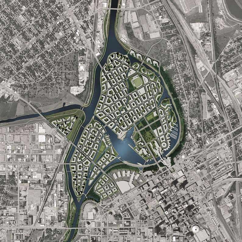
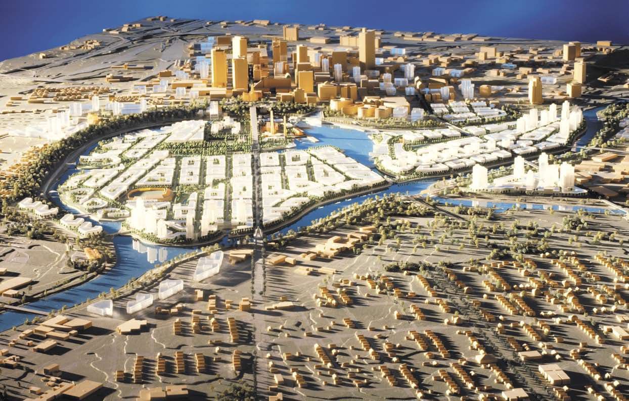
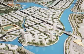
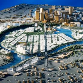
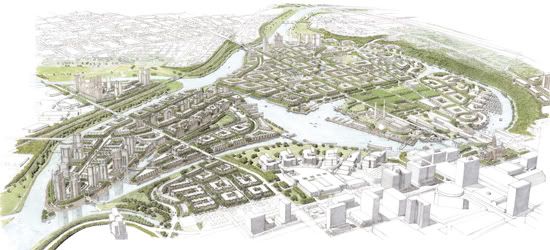
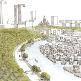
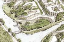
The flood control project is the catalyst for Trinity Uptown. Because of it, an exciting new addition to the waterfront will be a mile-and-a-half-long bypass channel running parallel to the Fort Worth & Western Railroad tracks and connecting the river west of North Main to south of White Settlement. It will be accompanied by numerous trails and open space. The new bypass channel and its related dam and isolation gates will allow the existing river to function as a calm, constant-level body of water that can be enjoyed year-round. The other tremendous addition is a small urban lake at the confluence of the Clear and West forks that will support a variety of boating and water activities.
Other project components include appropriate bridges and new or improved roads. This includes building bridges that go over railroad tracks to separate dangerous grade crossings, and extending White Settlement Road all the way into the central city, adding much-needed new access in that area. Valley storage mitigation sites, ecosystem improvements, and enhanced river accessibility through trails and pedestrian bridges will also be a part of this project.
The end result will provide infrastructure necessary for private development. As the "fastest-growing large city" (as defined by the U.S. Census Bureau), Fort Worth needs this development to support its rapidly growing population while still maintaining its "most livable city" designation.
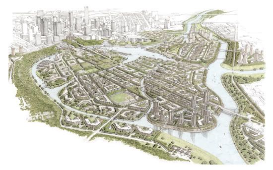
Trinity Uptown promises to become a richly diverse urban neighborhood linking downtown to the Stockyards and Cultural District. The area is bound on the north by Northside Drive and the Oakwood Cemetery property, to the west by the Fort Worth & Western Railroad and Henderson Street corridors, to the east by Samuels Avenue and to the south by Belknap Street.
Urban revitalization goals of the Central City Project:
View of proposed urban lake:
* Encourage mixed-use development of 800 acres in Fort Worth's central city
* Enable 10,000 new mixed-income residential units in the heart of Fort Worth
* Increase safety through elevated railroad crossings and pedestrian bridges
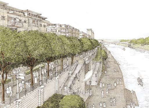
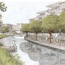
* Allow access and development right up to water's edge
* Improve access through University Drive and White Settlement Road.
* Upgrade public infrastructure with underground utilities
* Provide aesthetic and recreational focal points for the central city
* Create new and enhance existing linkages to other neighborhoods and districts
* Create an interior water feature, or urban lake
* Provide a higher normal water level on all river and waterways
One term of derision you will never hear mockingly spewed by NIMBYs in reference to Boston's Seaport development is "Forth Worth By The Sea". This city should be so lucky.
Here is a small excerpt from the Trinity Riverfront Vision website, which is huge and very thorough, and I recommend worth the visit to anyone interested in urban planning and development:
...Private development of the area will be possible once flood protection is in place and levees are removed to open up the land. The area will enable up to 10,000 new homes to be constructed in the area, providing a solution to the demand for high-density urban housing. Fort Worth is the fastest-growing large city in the United States. Its population is expected to increase by more than 50% in the next 20 years, and Trinity Uptown will provide a cost-efficient and viable alternative to annexation and urban sprawl.
Trinity Uptown offers a unique opportunity to integrate mixed-income housing into Fort Worth's central city. Focusing on residential development in the Trinity Uptown area will complement and reinforce the already successful adjoining neighborhoods without diluting their respective strengths.
The flood control project is the catalyst for Trinity Uptown. Because of it, an exciting new addition to the waterfront will be a mile-and-a-half-long bypass channel running parallel to the Fort Worth & Western Railroad tracks and connecting the river west of North Main to south of White Settlement. It will be accompanied by numerous trails and open space. The new bypass channel and its related dam and isolation gates will allow the existing river to function as a calm, constant-level body of water that can be enjoyed year-round. The other tremendous addition is a small urban lake at the confluence of the Clear and West forks that will support a variety of boating and water activities.
Other project components include appropriate bridges and new or improved roads. This includes building bridges that go over railroad tracks to separate dangerous grade crossings, and extending White Settlement Road all the way into the central city, adding much-needed new access in that area. Valley storage mitigation sites, ecosystem improvements, and enhanced river accessibility through trails and pedestrian bridges will also be a part of this project.
The end result will provide infrastructure necessary for private development. As the "fastest-growing large city" (as defined by the U.S. Census Bureau), Fort Worth needs this development to support its rapidly growing population while still maintaining its "most livable city" designation.
Trinity Uptown promises to become a richly diverse urban neighborhood linking downtown to the Stockyards and Cultural District. The area is bound on the north by Northside Drive and the Oakwood Cemetery property, to the west by the Fort Worth & Western Railroad and Henderson Street corridors, to the east by Samuels Avenue and to the south by Belknap Street.
Urban revitalization goals of the Central City Project:
View of proposed urban lake:
* Encourage mixed-use development of 800 acres in Fort Worth's central city
* Enable 10,000 new mixed-income residential units in the heart of Fort Worth
* Increase safety through elevated railroad crossings and pedestrian bridges
* Allow access and development right up to water's edge
* Improve access through University Drive and White Settlement Road.
* Upgrade public infrastructure with underground utilities
* Provide aesthetic and recreational focal points for the central city
* Create new and enhance existing linkages to other neighborhoods and districts
* Create an interior water feature, or urban lake
* Provide a higher normal water level on all river and waterways