T to roll out new maps to boost use of its buses
By Mac Daniel, Globe Staff | April 11, 2007
The MBTA faces a monumental challenge, in addition to its billion-dollar debt and failing infrastructure: enticing more people to ride the bus.
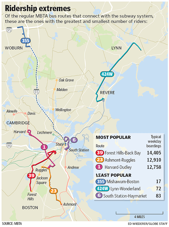
This is no easy task in Boston, where 177 bus routes attract less than half the number that ride the subway. Because of the way the hub-based subway system was designed, ridership has historically been isolated between commuter rail, bus, and the popular subway.
Most of all, riders and T officials say, people prefer the speed of the subway , don't like buses, or just don't know where the buses go.
A new MBTA program hopes to change that. Beginning this week, it will install detailed maps that meld bus routes with maps of neighborhoods around subway stops, showing for the first time the full scope of T bus and subway services in a given region.
T officials hope the maps show riders more travel options as well as more direct routes via buses, though riders say it might be a tough sell.
"The buses tend to be crowded, and sometimes people have a perception that they may not be as reliable, depending on the route," said Pamela Bush, coordinator of On the Move: Greater Boston Transportation Justice Coalition, a rider advocacy group. "And with the recent murder on the bus, it's kind of scary." An 18-year-old Hyde Park man was fatally shot on an MBTA bus March 30 .
Irving Feinberg, 64, of Wakefield, who typically takes a bus near his home to Oak Grove to get on the Orange Line, said he rarely takes another bus line. "I'm parked into a routine," he said.
The T program begins Friday with the installation of new maps, schedules, and signs at 10 stations pointing out bus stops . Another focus of the effort will be to feature 4-foot-by-4-foot signs showing roads and related bus routes.
Stations where the signs will be installed are Alewife, Wellington, Malden, Lechmere, Wonderland, Quincy Center, Jackson Square, Andrew, Forest Hills, and Davis. Based on customer feedback, the program will be suspended or expanded. The signs will be displayed near station exits to allow passengers to study routes . The route maps will also be incorporated into the T website trip planner.
"I think it would work," said Stephanie Rodriquez, 19, of Brighton, who sticks to the Green and Red lines when going to school at the University of Massachusetts at Boston. "But is that going to make them more money? I think something's behind that."
Daniel A. Grabauskas, general manager of the Massachusetts Bay Transportation Authority, said the T's only aim is better service. After the MBTA created free subway-to-bus transfers with the January fare increase (bus-to-subway transfers cost 45 cents), there is little money to be gained by the T if it gets more subway riders to take the bus. In addition, T officials said, the number of combined bus and subway pass users has risen since the fare increase took place.
"When you think of the spider map of the subway system, it's a good system and it covers a lot of area, but it is hub and spoke and there are a lot of areas that aren't reached," Grabauskas said.
By overlaying bus route maps atop localized maps of subway stops, he said, the T can show "this integrated system" that riders can get to at no additional cost.
Forty percent of T riders spend all or part of their time on a T bus, but it is a number the agency would like to see increase -- to take advantage of recent advances in bus service, including the purchase of 155 buses scheduled to be delivered by summer.
Marilia Pereira, 19, of Quincy, a dedicated Red Line rider, said the new maps and signs may allow her to explore the system a little more.
"I don't know it well enough, and that's what prevents me from using it that much," she said.