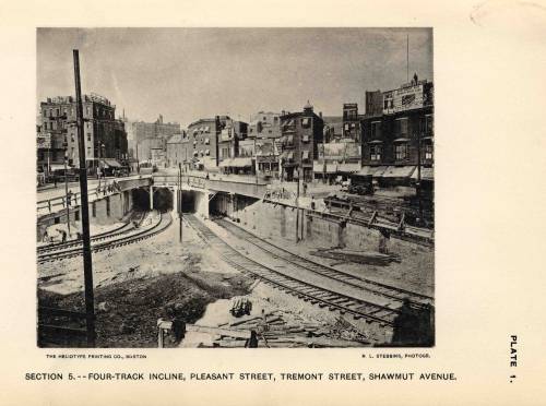
How much of it really needs to be tunneled? A surface reservation on Kneeland seems like it would fit (but no clue how to connect that to the Tremont tunnel...)
3 problems:
1) Kneeland's way too congested, especially by the 93 ramps. No way you can do street-running anywhere in downtown; there's a good reason Mass Ave. is the dividing line for surface LRT.
2) The only way to get to the Seaport is by linking into the Transitway, which requires some amount of tunneling. There are not any viable surface paths across Ft. Point Channel because of street congestion. The Transitway loop is deep below ground under the Essex/Lincoln/Surface intersection. You only entry points into it are: (a) due west on Essex or (b) in the middle of Chinatown Park. And because it is deep below ground the portal has to be a solid 2 blocks back.
2a) Not gonna fit a portal on Essex anywhere in
this vicinity. Go any further back and you're building SL Phase III all over again by underpinning the Orange Line and being mired in building mitigation hell. You also have no nearby access to the Central Subway with the Tremont Tunnel ending under Eliot Norton Park more than 3 blocks south of Boylston station on a one-way Tremont St.
2b) For the other Transitway trajectory you still end up digging under the Kneeland-Beach block all the same. Your single most delicate and expensive block of tunneling on the all-tunnel South End route...happens anyway.
3) As mentioned, Eliot Norton Park is end of the Tremont tunnel. So you're pointing due south towards South End. Oak St. ends at Harrison, and Harrison is a SB-only one-way. That won't work. Washington is ridiculously crowded near Tufts...that won't work. So your only free-flowing route is...Marginal St.. The same exact route the tunnel was going. And the same dig off Hudson from Kneeland to Beach to Chinatown Park to get into the Transitway.
ALTERNATIVE:
You can get to SS on the surface...but not the Transitway and not the Seaport.
1) Reactivate the Tremont tunnel.
2) Build Tufts station...a single 2-track part of it at least (but I'd structurally do up the whole triangular cavern so you can use the whole space later for diverging routes).
3) Build the 1-block Shawmut St. tunnel to Marginal and dip under the Orange Line. Build the 1-block under-Pike tunnel and portal-up the Herald St. wall to the Washington intersection, exactly as planned for the final Dudley LRT alignment. Leave a little cut in the wall under Marginal for adding the Transitway connecting tunnel later.
4) Dudley trolleys hang a right onto Washington. SS trolleys hang a left over the bridge, then right onto Marginal. Difficulty: you MUST change Marginal/Curve on these blocks into 2-way streets and ban parking on 1 side to fit trolleys here. That really doesn't introduce much new traffic because Marginal from Washington west is still a one-way...doesn't really tap much of a source for more cars.
4a) OR...air rights! Get some shit built over the Pike on the Washington-Harrison block, reservation to the side of Marginal so it can stay a one-way from Harrison, then glide onto Curve and turn that into a 2-way and whack the parking.
5) Up Hudson to the S. Station Connector block, then right turn onto SS Connector. Minor cosmetic difficulty: that pretty park behind One Greenway now has a trolley reservation splitting its middle.
6) Go up SS Connector and loop in the bus terminal at top.
Pros: It's something. Not real expensive, gets you to SS where the highest demand is. Significant load relief for Red/Orange. Dead minimal neighborhood impact. Gives you a full-build trajectory for Dudley LRT and tidies up the cheaper stuff like ducking the OL tunnel and building Tufts station. You can add the Transitway connecting tunnel later.
Cons: You don't get a Seaport direct...at all. Or a free transfer to Red or Silver because you're way upstairs in the bus terminal. There's now going to be unbearable pressure now to fund and build that connecting tunnel, so have to weigh how much shelf life this kludge surface loop really has before it gets abandoned.
FYI: What I would NOT do to save more money is dig up the park and just restore the old incline verbatim. I would spend the money to do the tunnel as far as the Pike portal and get everything settled up for the complete Dudley alignment. It's not expensive; this costs quite a bit less than Red-Blue. Difficulty with portaling straight up like the old days: Shawmut's a one-way, Oak ends at one-way Harrison with no easy way of getting around the block, and you go on a wild goose chase if you stick to Tremont and have to backtrack for a block. NO direct Orange Line transfer, negating most of the load-spreading to Red/Orange at DTX. Many more traffic lights any which way. And even if you can get Pike air rights dev on the Shawmut-Washington block and a reservation to keep you from having to make Marginal a 2-way...it's just all-around fugly on ops and will take noticeably longer to get to SS than if you just git 'r dun as far as the Herald/Washington portal.
So I wouldn't cheap out THAT much if you're looking for interim solutions to at least get to SS, punting Seaport directs to a second phase, or just flat-out slashing budgets to the bone. Build Tufts and those extra 2 tunneled blocks under the Pike.


