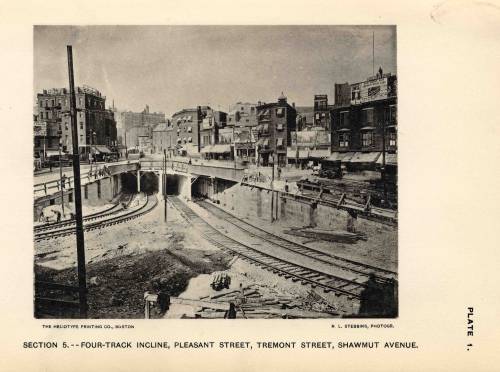
Crazy Transit Pitches

That is a really cool idea, maybe Seashore could throw them a couple more trolleys to help out too. Would be really nice if it could connect with NS too, and a NS/SS shuttle could run along with the circular seaport route. The OL/GL connection would be nice too.
 
Loops are bad transit: nobody wants to ride all the way around the long way.
 
Was it in here we were talking about using the Tremont subway for a connection to the Huntington Subway/Dudley/Seaport?

Anyway, I was bored and decided to see how it could actually all be mapped out. My goals were
a) No conflicting movements. All junctions had to be grade separated for maximum throughput.
b) Minimum amount of platforms. Less platforms means more on-platform transfers, as well as less space taken up and infrastructure to maintain.
c) Tremont Loop. With the northern extensions, I wanted to have a loop track to be able to turn trains coming in from Tremont Street right back again. After Government Center, the only place to currently turn trains is Blanford Street.

After coming up with an elaborate multi-level design with four platforms on three separate streets, I had the epiphany to have the trains cross back on themselves, getting this:

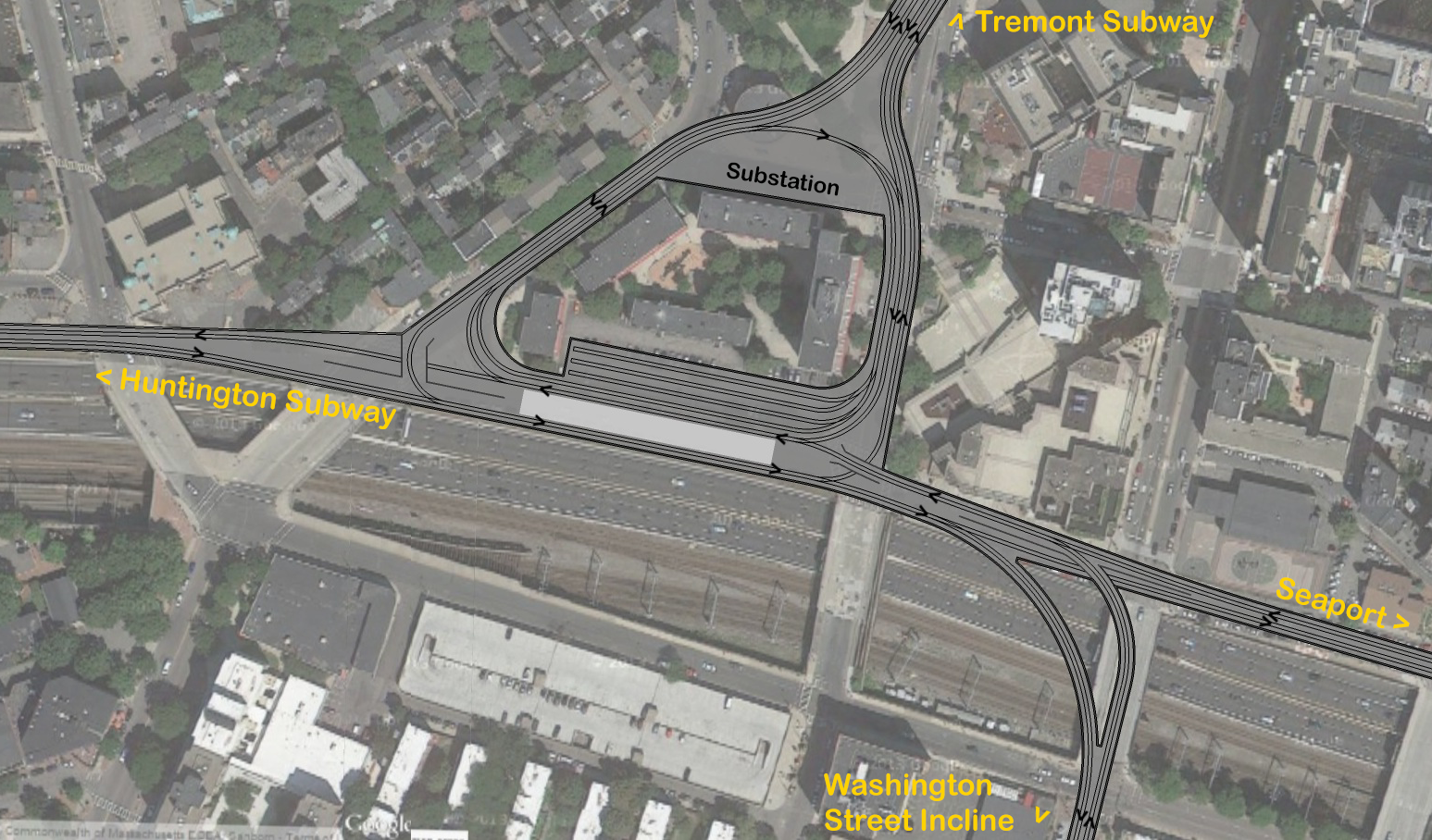
12260141186_3e9d2772cc_o.png


A single 30' platform services every line, allowing this to be the ultimate transfer station. The only confusing thing about it is that you can board a train going to Park Street on either side of the platform, onto trains facing opposite directions. Both platform tracks can be used to loop trains. There is more than enough space to carve out for a large substation for the power boost you'd likely need, as well as a four track yard with a dedicated lead. Both the yard and platform are 310'+, allowing for four car trains. With the exception of Dudley > Seaport and Seaport > Dudley (a route I don't see much demand for), any line can go to any destination.


Whaddya think?
 
Last edited:
This is awesome Davem. I want to incorporate this into my map as well, it seems more realistic than the Essex St. tunnel.
 
The only real issue I see with this plan is that it would be difficult to get a connection to the Orange Line at NEMC, but perhaps as part of the project a connection between Boylston and Chinatown could be made.

Whaddya think?

Really cool! A couple things:

1) You already have the difficulty of OL connections in mind, and I'm not sure even a ped tunnel between Boylston and Chinatown is realistic. You might really be punting the GL/OL transfer here, although you could argue that they meet at Back Bay if the Huntington Ave. subway is built.

2) Can you really fit 4 tracks in the existing Boylston portal tunnel? The need to replace it was one of the things that ballooned SL3's cost.

3) Can you still get vertical clearance to go under the Pike if you've climbed above the Seaport tunnel? That could be addressed by simply sending the Washington St. bound tunnel under the Seaport one.

4) Are you sacrificing the Washington St. overpass for this? F-Line had a different vision for the incline which would have aligned it with the Turnpike and NEC.

5) Unless you deck the Turnpike (which is another of your brilliant visions), that station has less of a catchment than F-Line's version 1 block north. If you do deck the Pike using something like your plan, where would the headhouses be for this (honestly, for a mega-transfer point that platform looks small to me...)?
 
Really cool! A couple things:

1) You already have the difficulty of OL connections in mind, and I'm not sure even a ped tunnel between Boylston and Chinatown is realistic. You might really be punting the GL/OL transfer here, although you could argue that they meet at Back Bay if the Huntington Ave. subway is built.
Yes, there is the transfer at Back bay, however looking at some maps it appears NEMC is RIGHT THERE, a pedestrian tunnel shouldn't be an issue. I thought it was further north.
2) Can you really fit 4 tracks in the existing Boylston portal tunnel? The need to replace it was one of the things that ballooned SL3's cost.
This is after the bellmouth, there are four tracks at the portal:
tumblr_ms6xm59CqG1rrufk0o1_500.jpg

3) Can you still get vertical clearance to go under the Pike if you've climbed above the Seaport tunnel? That could be addressed by simply sending the Washington St. bound tunnel under the Seaport one.
All of this has to get underneath the orange line tunnel, so the Pike is not an issue (it's going to be deep). But yes, what goes above/beneath each other can be easily changed.
4) Are you sacrificing the Washington St. overpass for this? F-Line had a different vision for the incline which would have aligned it with the Turnpike and NEC.
Sorry if its not clear, this is all underground. The portal to Washington street would be south, out of frame.
5) Unless you deck the Turnpike (which is another of your brilliant visions), that station has less of a catchment than F-Line's version 1 block north. If you do deck the Pike using something like your plan, where would the headhouses be for this (honestly, for a mega-transfer point that platform looks small to me...)?
It's all underground, there would be a mezzanine above with sidewalk access/concourse to NEMC. If my decking plan ever came to fruition, egress would be through some buildings lobby. Even if the station doesn't produce a single rider, that's okay because it's not really its purpose. It's meant to allow free transfers between the four (or more) lines running through here. Grabbing some new riders from Bay Village or the former NY Streets is just a bonus.

As for F-lines plan, its great, but it's not to scale. You need 300' platforms to fit a four car train, and that won't fit in the much smaller triangle. The platform only looks small because its 30' wide, the typical platform on the T is 5-15 feet. (Look at the adjacent apartment buildings, it's larger than their footprint.)

That would be a rather steep incline for the flyover?
I left ~100' for a grade change at any flyover. Assuming one set of tracks goes down while the other goes up, that shouldn't be too bad for trolleys to climb 20' or so.
 
Lower left curve is what - about 120 degrees? more? If you thought the Boylston curve was bad, I think you will have people losing their lunch on that puppy...
 
Lower left curve is what - about 120 degrees? more? If you thought the Boylston curve was bad, I think you will have people losing their lunch on that puppy...

If you are going to have to be deep anyway (to get under the Orange Line), why not put some more of this under the Pike, and ease some of the curves.
 
Was it in here we were talking about using the Tremont subway for a connection to the Huntington Subway/Dudley/Seaport?

Anyway, I was bored and decided to see how it could actually all be mapped out. My goals were
a) No conflicting movements. All junctions had to be grade separated for maximum throughput.
b) Minimum amount of platforms. Less platforms means more on-platform transfers, as well as less space taken up and infrastructure to maintain.
c) Tremont Loop. With the northern extensions, I wanted to have a loop track to be able to turn trains coming in from Tremont Street right back again. After Government Center, the only place to currently turn trains is Blanford Street.

After coming up with an elaborate multi-level design with four platforms on three separate streets, I had the epiphany to have the trains cross back on themselves, getting this:

12260141186_3e9d2772cc_o.png


A single 30' platform services every line, allowing this to be the ultimate transfer station. The only confusing thing about it is that you can board a train going to Park Street on either side of the platform, onto trains facing opposite directions. Both platform tracks can be used to loop trains. There is more than enough space to carve out for a large substation for the power boost you'd likely need, as well as a four track yard with a dedicated lead. Both the yard and platform are 310'+, allowing for four car trains. With the exception of Dudley > Seaport and Seaport > Dudley (a route I don't see much demand for), any line can go to any destination.


Whaddya think?

Track layout is roughly what I'd do, but some caveats that require consolidation.

-- The Orange Line tunnel splits the corner of Marginal/Shawmut straight down the middle. You can see on the overhead view of the Quincy School how the building foundations are conspicuously arranged around the tunnel such that it splits it down the middle. So you have a major problem here doing such a complicated, wide-footprint junction slicing deep under the OL at an angle.

-- Similarly, you've got a major problem with the inclines to have a flying junction at different levels at the exact point the OL passes. This is going to have to go well over 125 ft. deep to fit 3 levels of tunnel.

-- Related...that storage yard isn't going to work in the midst of all those varying depths.

-- Shawmut is not so wide that 4 tracks is doable without abutter impacts. Neither is the storage yard. Have to get rid of.

-- Marginal is not so wide that a station can be shivved in without abutter impacts. You are much better off using the empty space under the park block for that.

-- You don't have an easy place to portal-up for Washington St. There's no room on-alignment with the street.


You are going to need to whack the entire connecting block between Tremont and Shawmut and consolidate all this infrastructure under the wye at Eliot Norton Park. That is the only way to consolidate for a slip under the OL. If you take a diagonal turn from the SS direction under the Tufts OL station entrance at the Marginal/Shawmut corner you can slip under the OL at a 90-degree angle with a semi-sharp but not awful curve and limit the impact and underpinning of the OL to one single point.

See my cruder rendering for how this would have to work:

260cyld.jpg


Now...also keep in mind that you have way way more space under the park than you're using in your design. The vacant Church of All Nations building is going to get demolished one of these days because it's structurally unstable, and nothing is likely to get built in its place other than more parkland or a badly-needed playground. Since all underneath is just one dirt-covered open pit, you can spread that wye out across the entire block to make thru-running possible without sharp curves. And put your Tufts station there on a giant wedge serving all directions. Including short-turns that loop around if you consolidate your loop that was on the Marginal connecting block to the south flank of the park.

This will not crimp your capacity despite introducing some curves and a 1-block diversion.

-- Loads here are not the same as the Central Subway. Even if this is a parallel flank to the Central Subway you are still making the GL-wide traffic a little more diffuse by load-spreading. The Grand Junction pinging between Lechmere and BU Bridge does a little bit more.

-- The Tremont tunnel feeding this from Boylston is already a flying junction. So the wye leg being used as an at-grade junction for thru running and looping is not a bottleneck. You don't need to worry about introducing a new Copley Jct.

-- Consolidation under the park is your best bet for having the most functional all-direction Tufts station. You also have all the space in the world for tracks and all-direction junctions on both sides of the wye.

-- A layover yard is not needed here. You will have one on the SS branch at Silver Line Way. The Huntington branch will presumably connect to the D and have full access to Riverside and Reservoir. If the E goes back to Forest Hills there's Arborway Yard. And Innerbelt Yard feeds all the southbound traffic from Somerville that would be feeding into the Tremont Tunnel. If you want to have a storage track along the wye for looping traffic, you have enough space along the south end of the park and the cross block of Tremont to put one in that has space for 2 or 3 trains. That's probably all you need.

-- The track split for Washington St. light rail is easiest to do right where you're diagonally turning from Shawmut to Marginal across the plaza. And since this is branch traffic, SS traffic is going to be mildly speed restricted coming off a steep dip under the OL onto a curve, and all of your thru-running traffic is consolidated back at the Park an at-grade junction is no problem. The Washington tunnel can simply split off dead straight while the SS tunnel curves off. At-grade traffic would always be prioritized for SS with Washington getting a pause around any train meets because it is the lowest-volume branch. But you would still not have any Copley Jct. situations here.

-- To portal-up to Washington you must come up on the NEC hugging the Herald St. wall on the space currently occupied by all those electrical boxes. Then graft a trolley light cycle onto the Washington/Herald intersection. The NEC will never need to use that space because it's the Herald's former freight siding, and you can't portal on Washington-proper without blowing something up so this is your best bet.

-- All of this consolidates the infrastructure about as much as possible without introducing harder digging, multi-level tunnels, and additional blocks worth of digs. I know it is not utter highest-speed perfection, but because of all I outlined there are still no bottlenecks here. It's a bend-not-break you really have to do because it's the difference between $1B spent on just these blocks and some hellish mitigation, or one-third that cost with pretty straightforwardly minimized risks that still achieves every single one of your service goals at (I think) equal capacity given the way the whole Green Line gets spread out away from Central Subway overload.
 
Eliot Norton park just isn't large enough to fit 300' platforms. What's the point in building a station if it is going to be functionally obsolete if four car trains happen? The whole reason I did this was as a proof-of-concept for your idea. In fact, the wedge was one of the first things I tried.

12274121175_ef3826cbb5_c.jpg


In reality, the usable space is less than that, because you can't have a platformed train fouling all the switches. Doing three islands won't work either for the same reason. To be able to through-route trains from Back Bay to the Seaport, the platforms can't be at the park (or at least not the one for BB-SS trains).

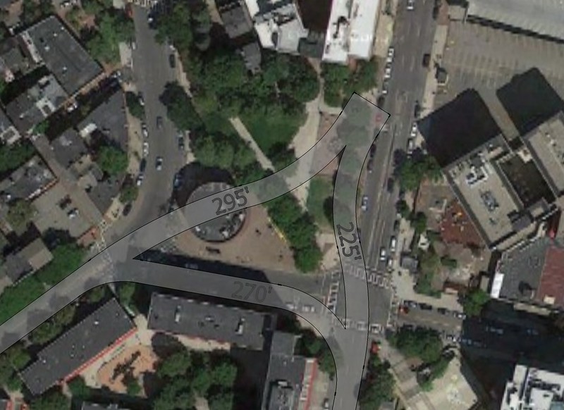
Looking at your map, I think you think the portal is further north than it really is. To roughly place mine, I looked at this map of the actual portal and where it aligned with the corner of Tremont and Shawmut, as well as historic aerials and some old atlases. I think I'm pretty close, within ten feet. Trust me, I didn't just pull my concept out of my ass. This is after about a dozen different iterations, plus a bunch of sketches by hand to see what might/might not work. For shits and giggles, here's what it was all looking at before I figured out the design I posted above.

12274919694_2999055d17_c.jpg


The yard I threw in because the parking lot is there, and to see if I could. Hardly mission critical. As for Shawmut and Marginal not being large enough for x tracks... they are. (Also I only have three tracks, two if you get rid of the yard) Granted google earth has a certain variance in how accurate it's imagery is, but its within a foot or two. The tracks are 4'-8.5" at 12' on center, which I believe is spec, plus an extra two feet of buffer space where the track is next to a tunnel wall. If it fits on that drawing, well, it fits in real life. The only abutter on this section of Marginal is also that single low-rise building, hardly much of an issue to deal with (some designs I came up with just demolished that building).


Similarly, Washington is 50' wide at this location. With a 26' wide portal (as on the E and B) that still leaves 12' on each side for travel lanes. Even better, if you have it portal 200' south of Herald st, there are two large parking lots behind the church that could be partially used to widen Washington at this point, giving even more room. No need for a short, steep portal and hard right turn onto Washington.


As for the complexities of construction, that's the whole joy of building on this one particular spot, is it not? The junctions wouldn't need to be separate tunnels, a large excavation could be done for the whole thing, just like a basement. The different fly overs/unders could then be configured within the box.


Getting under the orange line is something I need to redesign for. The curves are also harsher than I thought. I only had the 42' radius spec for the park street loop, so I had all my curves exceed that by a large scale. I didn't realize until today that the Boylston curve is 81' on the inside track, which is more than some of my curves, so they need to be redesigned.
 
Last edited:
Eliot Norton park just isn't large enough to fit 300' platforms. What's the point in building a station if it is going to be functionally obsolete if four car trains happen? The whole reason I did this was as a proof-of-concept for your idea. In fact, the wedge was one of the first things I tried.

In reality, the usable space is less than that, because you can't have a platformed train fouling all the switches. Doing three islands won't work either for the same reason. To be able to through-route trains from Back Bay to the Seaport, the platforms can't be at the park (or at least not the one for BB-SS trains).

Then I think you're going to have to compromise because the Orange Line impacts are severe on Marginal. I do not think you can have 3 levels of tunnels crossing each other at angles in one spot with steep inclines as they pass. That Marginal/Shawmut intersection must be simplified a lot or this is a billion-dollar project easy with blockers that escalate to potential project fatality.

The easiest way to save it is to have one GL tunnel crossing the intersection at an angle and intersecting under the OL at a clean 90-degree angle. Anything else is going to be pure pain.

If this means you have a platform length issue at Tufts, so be it. You could try sweeping the platforms out at wider angles to cover more of the park area. GL low platforms work just fine on curves. But you're going to have to make some tough compromises with the abundance of flyovers and fluid perfection of all these around-the-block tunnels because so much stacked up around that bad-angle Orange crossing is killer. Bottom line is you have the open triangle there and you do not have open anything on the Tremont-Shawmut block of Marginal. If you have to push the limits somewhere, the park is it.


The yard I threw in because the parking lot is there, and to see if I could. Hardly mission critical. As for Shawmut and Marginal not being large enough for x tracks... they are. (Also I only have three tracks, two if you get rid of the yard) Granted google earth has a certain variance in how accurate it's imagery is, but its within a foot or two. The tracks are 4'-8.5" at 12' on center, which I believe is spec, plus an extra two feet of buffer space where the track is next to a tunnel wall. If it fits on that drawing, well, it fits in real life. The only abutter on this section of Marginal is also that single low-rise building, hardly much of an issue to deal with (some designs I came up with just demolished that building).

You can't go by the street footprint, because Essex's street footprint is plenty wide enough for a BRT tunnel but still proved a SL Phase III project fatality for building mitigation. You need generous buffers to have certainty the impacts are not going to spiral out of control. Look at Red-Blue on ultra-wide Cambridge St. That's about as ideal as it gets for tunneling under, and doesn't even require closing the right lanes of the road to build. But they still had some indirect abutter effects to solve. So I think if you're tunneling under Shawmut you need to keep the tunnel walls tucked inside the travel lanes with enough buffer that the parking lanes are outside the tunnel footprint.

It's not ironclad, but be prepared to tack $100M in contingency for pushing the envelope. It piles up really, really fast.


Similarly, Washington is 50' wide at this location. With a 26' wide portal (as on the E and B) that still leaves 12' on each side for travel lanes. Even better, if you have it portal 200' south of Herald st, there are two large parking lots behind the church that could be partially used to widen Washington at this point, giving even more room. No need for a short, steep portal and hard right turn onto Washington.

12' travel lanes with no shoulder are way too narrow. All 3 other portals pop up on reservations on roads with 4 lanes + parking lanes. The last portal Boston had that popped up straight onto street-running with no reservation was the ultra-wide block of Boylston between Charles Ext. and Arlington. Washington is way narrower than this. And if you are turning out on the side into a parking lot there's no way to get on-alignment into a parking lot without knocking at least one large building. It's too shallow to the surface to spare the foundations.

So chuck in property acquisition, abutter issues, traffic problems, and an extra block of tunneling. $100M for no operational improvements.

I think you're getting a little too perfectionist here at trying to have gentle curves, tangent track, and gentle grades everywhere as if this were the Red Line. Trolleys are a lot more nimble than that. As long as the curves aren't pushing the turn minimum radius of an LRV to the absolute limit through a too-crowded tunnel like Boylston curve it's not going to introduce new bottlenecks. Not here with such wide stop spacing between Boylston, Tufts, and the next stop in any direction. And not with traffic load-spread around the subway.

As for the complexities of construction, that's the whole joy of building on this one particular spot, is it not? The junctions wouldn't need to be separate tunnels, a large excavation could be done for the whole thing, just like a basement. The different fly overs/unders could then be configured within the box.

Again...I think you're building a project on these blocks 50-60% more expensive for 10% more performance on a flank of the Green Line that will have 30% less traffic at it's busiest possible growth cap than the Central Subway has today because of the way the Green Line is redistributed all around. It doesn't have Kenmore, Copley, Park, GC, North Station on it all on one seat; Seaport + SS + BBY, etc. or Seaport + SS + Park/GC/NS still doesn't trump the Central Subway at wildest growth projections. It is the #2 load-bearing flank...a significant one, but not co-equal to the current subway. And having parallel flanks like this and the Grand Junction does spread the traffic and redundancy around that growth exceeding projections still is not going to stress the design to the point where flyover city and a sprawling 3-block junction is needed.

I think this is far, far less than ideal bang-for-buck for the extra complexity, excessive for the load, has too many abutter impacts, and needs to be put on a major diet.


Getting under the orange line is something I need to redesign for. The curves are also harsher than I thought. I only had the 42' radius spec for the park street loop, so I had all my curves exceed that by a large scale. I didn't realize until today that the Boylston curve is 81' on the inside track, which is more than some of my curves, so they need to be redesigned.

Orange is the blocker. I really just don't think you can do half the infrastructure you have crossing that one intersection. It has to be slashed back to absolute minimum point of impact. Which means if you have tough decisions to make about a convergence around the park to make it work. That's tough, as widening the wedge could introduce building impacts on the sides of the park. But it's a single point of impacts vs. impacts on 3 whole sides of the block from those wide tunnels and extra block of tunnels, and a living nightmare of impacts with 3 tunnel levels converging at a bad angle.


For the above reasons about this not being the Central Subway, I wouldn't get too bent out of shape about the curves. The run from Boylston to Tufts through the existing flyovers was a fast one, and the run to SS and the run to BBY once on Marginal are going to fly at 35 MPH from lack of over-close station spacing or sharp curves on those trajectories. Coupled with the traffic loads being quite a bit less than Central Subway and the Tremont tunnel already being flown-over into a 4-tracker before these blocks even start...tightish curves and at-grade junctions at the wye and Washington split bottleneck nothing.

Pocket the 50% cost savings and sharply reduced construction mitigation as a gift and take the 90%-as-good service. It's a Transit OCD level of extreme overkill for the negligible real-world difference in service.
 
12' travel lanes with no shoulder are way too narrow. All 3 other portals pop up on reservations on roads with 4 lanes + parking lanes. The last portal Boston had that popped up straight onto street-running with no reservation was the ultra-wide block of Boylston between Charles Ext. and Arlington. Washington is way narrower than this. And if you are turning out on the side into a parking lot there's no way to get on-alignment into a parking lot without knocking at least one large building. It's too shallow to the surface to spare the foundations.

So chuck in property acquisition, abutter issues, traffic problems, and an extra block of tunneling. $100M for no operational improvements.

Upon closer inspection of Washington between Herald and Dover there is NOTHING of substance on the west side of the street. A chinese food place, parking lots, and a warehouse. If there is a better place to widen the street for a trolley reservation, I can't find it.

--not to mention, with the ink block and that other development, this entire side of the street will likely be rebuilt within the coming years. Perfect opportunity to rebuild the street here.
 
Just to briefly respond to Matthew's point about c_combat's Waterfront loop idea (which I am intrigued by):

Loops are bad transit: nobody wants to ride all the way around the long way.

Why can't you have trolleys running in both directions?
 
Was it in here we were talking about using the Tremont subway for a connection to the Huntington Subway/Dudley/Seaport?

Anyway, I was bored and decided to see how it could actually all be mapped out. My goals were
a) No conflicting movements. All junctions had to be grade separated for maximum throughput.
b) Minimum amount of platforms. Less platforms means more on-platform transfers, as well as less space taken up and infrastructure to maintain.
c) Tremont Loop. With the northern extensions, I wanted to have a loop track to be able to turn trains coming in from Tremont Street right back again. After Government Center, the only place to currently turn trains is Blanford Street.

After coming up with an elaborate multi-level design with four platforms on three separate streets, I had the epiphany to have the trains cross back on themselves, getting this:

12260141186_3e9d2772cc_o.png


A single 30' platform services every line, allowing this to be the ultimate transfer station. The only confusing thing about it is that you can board a train going to Park Street on either side of the platform, onto trains facing opposite directions. Both platform tracks can be used to loop trains. There is more than enough space to carve out for a large substation for the power boost you'd likely need, as well as a four track yard with a dedicated lead. Both the yard and platform are 310'+, allowing for four car trains. With the exception of Dudley > Seaport and Seaport > Dudley (a route I don't see much demand for), any line can go to any destination.


Whaddya think?

THIS IS AWESOME.

I sketched out something a bit similar as well, but obviously nothing that looked this legible and this awesome.

I fully support this. :)
 
Why can't you have trolleys running in both directions?

Makes it slightly better but there's a couple of problems: a circle is not the direct route to anywhere along it, and you need a control point: where does it go?

Circular routes are generally used, by riders, for portions of the arc which are less than 180 degrees around, and so it's really a collection of overlapping arc-shaped travel patterns which are served by thru-running.

But circles have no ends, so there's no natural "termini control point" at which you do layover/break period. So you have to pick a spot on the circle to be that layover point, where the drivers change, or take a break. And anyone who's trip goes through that point has to wait. Kind of a pain.

Many cities' circular routes are broken up into two or more segments for this reason...

In this case, though, it's really not a circle, it's a rectangle. Because the two sides of the loop are so close together, anyone interested in going 180 degrees would just walk.

Really, this isn't a loop as much as it is a pair of branches serving the inner and outer waterfront, linking it with South Station and the periphery of the Financial District.

A natural terminus would be South Station, since presumably most riders would be going there.
 
Just think why they don't run B and C as a loop.

Anyway it's gimmick transit either way, here. I'd rather they use those silly tourist "trolleys" and save money for real transit.
 
Just think why they don't run B and C as a loop.

Anyway it's gimmick transit either way, here. I'd rather they use those silly tourist "trolleys" and save money for real transit.

It may be a gimmick, but don't knock gimmicks. Gimmicks normalize the novel.

As for the comparison to the B and C: I don't see it. Except at the ends, the B and C are too far apart to walk between, which is precisely why the circulator model might just work on the waterfront as c_combat has proposed.

And, in theory, if Boston College were to disappear, the T could run a de facto Beacon-Commonwealth loop, with a Commonwealth branch and Beacon branch both terminating at Cleveland Circle.

Again, don't think of the proposed waterfront tram as a loop: think of it as a pair of branches which meet at a pair of common termini.

What I'd love would be to link up a Seaport Tram with a small network of Heritage Trolleys, geared toward serving Boston's entire waterfront and old city. Not my idea, someone else (HenryAlan?) definitely has proposed a version of it on the board somewhere before, but I can't find it at all right now. (Maybe add a branch up to Charlestown Navy Yard?)
 

Back
Top