Crazy Transit Pitches

I thought the slope of the hill Broadway goes up in Everett, not to mention the fact that Broadway is realistically too narrow to do anything other than curb-side transit lanes -- and maybe too narrow to accommodate catenary? -- makes surface-running there a non-starter?

And we all know what curb-side transit lanes get you without a train-mounted device to yeet cars out of the way: double-parkers.
 
Do you have a sense of which cities and towns:
1. Have always wanted rail transit, but never gotten it, or never gotten it of the scale and mode they deserve
Not necessarily deserving but Lexington. Very surprisingly Lexington has wanted the Redline for 50 years but it’s not possible to go to Lexington without going through Arlington.

I bring this up again because there’s something incredibly wrong where people in one town can completely block a public service from getting to a town that wants or needs it. Lexington was SOL being surrounded by Waltham, Burlington, Woburn, and Arlington. In the middle ground, projects like South Coast Rail have to make roundabout plans work instead. Fall River and New Bedford were lucky to still have the existing freight line that avoids Easton and Raynham.

In the same way that mistakes in the past shouldn’t dictate the current ability to perform transit expansion, I don’t think people should be able to completely block infrastructure that passes by them if it doesn’t encroach on their property. If you decided to buy the home that abuts a railroad ROW, you can’t complain when the ROW is active again.
 
Not necessarily deserving but Lexington. Very surprisingly Lexington has wanted the Redline for 50 years but it’s not possible to go to Lexington without going through Arlington.

That I find hard to believe. I imagine their complaints were the same as Arlington's was, with maybe less complaints about being the last stop... given that if they went to Lexington it would probably go all the way to 128.

I do think Red @ 128 would be very popular in an RTO world.
 
That I find hard to believe. I imagine their complaints were the same as Arlington's was, with maybe less complaints about being the last stop... given that if they went to Lexington it would probably go all the way to 128.

I do think Red @ 128 would be very popular in an RTO world.
Well believe it cause that was the reality. The plan in the late 60s was an extension to Bedford Depot. The mayors of both Bedford and Lexington along with the recently exploded populations were very much on board with the idea of a rapid connection to Boston from their quiet suburbs following the demise of the twice daily B&M service. Arlington originally in ‘70-‘72 was on board with the RLX but the funding only existed to extend to Arlington Heights at the time. The people did not like the idea of many cars driving and parking in their town (ironic) and would only vote yes if it went to 128 which there wasn’t enough money for. Time moved on to the mid 70s when Arlington’s opposition to RLX reached its height due to its very Catholic populace siding with the pastor and priests of the church and catholic school that abuts the ROW in being against the return of rail activity. I kid you not, the best they could come up with was saying that RLX would bring “things you don’t want” and that was enough for people to be overwhelmingly against it until now.

Edit: Forgot the important part: Lexington wasn’t opposed like Arlington because traffic was already bad and Lexington lacks a higher capacity roadway near where most people lived. They also lacked the bus service of Arlington that was at the time more frequent and faster than rail. For the people of Lexington, they were much farther from Boston, making a rapid transit connection the best option.
 
Last edited:
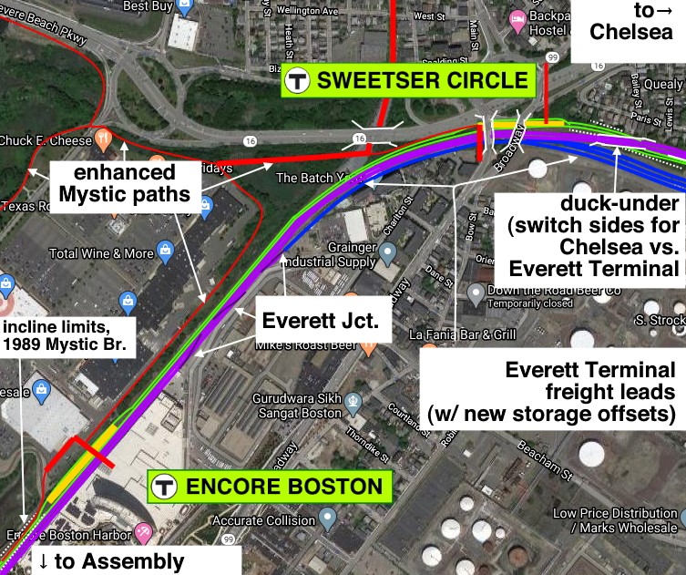
Are you suggesting, say, dedicated Urban Ring ROW to Sweetser Circle and then street-running on Broadway in Everett? (A flying junction for another branch to Chelsea and Airport later)

That sounds like a very natural, yet seldom mentioned idea. Seems like a northside counterpart to the Nubian branch, which IMO deserves to be on the priority list too.

However, the fact that Everett residents voted in favor of SL6 to Kendall over Haymarket makes me a bit more skeptical. An OSR Green Line ride further into downtown will hopefully do better.
Yeah, at least to Sweetser Circle, and further north if street running is feasible. The ROW from GLX (near the new GL storage yard) to Sweetser is pretty much there, as laid out in detail by F-Line a while ago on aB. Everett is eager for new housing development and transit and deserves, in every sense of the word, a rail transit line.
 
Yeah, at least to Sweetser Circle, and further north if street running is feasible. The ROW from GLX (near the new GL storage yard) to Sweetser is pretty much there, as laid out in detail by F-Line a while ago on aB. Everett is eager for new housing development and transit and deserves, in every sense of the word, a rail transit line.
Here are the previous layouts from F-Line that could be used for a GL branch to Everett (shown from north to south):

53056271050_4b3afb2dd5_o.jpg


53056371053_a34554554a_b.jpg


53055895681_ff93cfaabe_b.jpg
 
Last edited:
Unless you are gonna Cut N Cover, I would consider rail trails off limits. At the very least, it certainly fits Crazy.

Plus they are building that new Ped bridge.
 
Last edited:
Unless you are gonna Cut N Cover, I would consider rail trails off limits. At the very least, it certainly fits Crazy.

Plus they are building that new Ped bridge.
Yes, F-Line posted these layouts of his a while ago, before the Ped Bridge over the Mystic River was finalized. I just wanted to post these to show that a ROW is possible for a GL branch to Everett.
 
I know next-to-nothing about ferries and water transportation. But when has lack-of-expertise ever gotten in the way of drawing pretty lines on a map, amirite??

Ahem.

We can call this "EZ-Ride, the next generation: EZ-Float".

View attachment 38850

A Charles Ferry route, with stops at
  • North Station
  • Kendall
  • MIT/Mass Ave
  • BU
with optional non-stop runs to reduce travel times.

At North Station, plop a dock/use existing docks behind the MGH building, and add a pedestrian overpass from the far end of the commuter rail platforms so passengers can walk directly without diverting through the station.

View attachment 38851

At Kendall, see if you fit under the Broad Canal Drawbridge (lol no) to get closer to the heart of the action. If not, look for places to stop just north and/or south of Longfellow:

View attachment 38852

Ten minute walksheds -- am slightly surprised the western one gets you a "deeper" walkshed, but probably is impacted by the spaghetti at the bridge, the canal, and the tracks themselves:

View attachment 38853

Plunk another stop somewhere near Mass Ave, and then have fun picking a place to stop near BU:

View attachment 38854

~~~

Okay, so aside from the aesthetic/romantic appeal of the Charles River becoming more like the Thames (as a piece of geography that knits together the region, rather than split it), what does this proposal actually have going in favor of it?

Well, to start, you have the North Station <> Kendall commute, currently covered by EZ-Ride, which claims to be able to do the journey in 10 minutes. (The Green <> Red journey is timetabled at least 16 minutes.) A ferry could potentially provide greater reliability by bypassing traffic -- if it can be faster.

Can it be faster than a bus? Well, maybe. The Charlestown Ferry is timetabled at 10 minutes to travel one mile, for an average speed at 6 mph. I have zero idea whether conditions on the Charles permit similar speeds, but it's the only number I've got for now, so I'm rolling with it. North Station <> Kendall-ish is also about a mile. So, that suggests that EZ-Float could actually compete with EZ-Ride on travel times, though the ferry gets a penalty due to the 5-10 min walk on the Cambridge side.

EZ-Ride also serves MIT, timetabled at about 20 minutes (depending where on campus). North Station <> Mass Ave via the Charles is 1.6 miles, which non-stop at 6 mph could be cleared in 16 minutes. Again, not a clear winner, but perhaps competitive if there is better reliability.

Finally, there is BU. North Station <> BU Bridge (as an arbitrary choice for a stop location) is 2.7 miles, which non-stop would be 27 minutes. North Station <> BU Central via the Green Line is something like 32 minutes, and requires a transfer or a 10+ minute walk. So, once again, we don't see a clear winner, but it seems like there is a somewhat similar ballpark maybe.

~~~

One outstanding question is frequency and rolling (floating?) stock needs. For comparison, the T uses (I believe) two boats for the Charlestown Ferry service, for 15-minute service during peak. EZ-Ride's frequency varies, but during high peak sees 12-minute headways.

Just to sketch out some numbers, let's look at the "full-build" North Station <> BU service (and we'll assume it's non-stop for the moment. 27 minutes of travel time, plus 3 minutes per stop (probably a little tight) puts a round-trip at 60 minutes. To achieve 12-minute headways, you would need five ferries in operation at once. So a more realistic estimate would be six or seven, depending on how many stops you make and how tight your "layovers" are.

That's... a lot of boats. Even just a North Station <> Kendall service would probably need three boats in order to hit those 12-minute headways.

There's also a literal pinch point under the Craigie Bridge. Again, I know next to nothing here, but that looks pretty narrow and I'm guessing can't handle two boats passing each other in opposite directions. So maybe 12-min headways aren't even possible anyway.

~~~

So, does this work? Ehn, probably not. At least not as a competitive replacement for EZ-Ride. A one-seat North Station <> BU service every 15-20 or 20-30 minutes maybe could be potentially interesting, but hardly a slam dunk.

The outer harbor services (e.g. to Hingham) are (I believe) catamarans that zip along at 20 mph. So maybe there are faster boats out there that could make this trip competitive, I don't know. They'd need to be pretty narrow to fit through the Craigie, which looks to be about 45 feet wide.

So, while it's fun to imagine, the days of commuting under the Longfellow rather than over it are still probably pretty far off.

Part of the reason I didn't go farther than Cambridgeport was because at that point the Charles begins to curve around and becomes much more roundabout for journeys to North Station; the interesting thing about the North Station <> Kendall pair is that the "as the crow flies" route is indeed directly through the Charles, so a water service can potentially be more direct. This is true to a lesser extent for the MIT and BU pairs as well.

That said, some upstream destination pairs would indeed be linked pretty directly via a path along the river:
  • Harvard <> BU
  • Harvard <> Arsenal
  • Harvard <> Watertown
  • Watertown <> Arsenal
So, like many transit routes, a Watertown <> North Station service could be built off of shorter journey pairs, even if the longer journeys are less competitive.

I suspect Kendall, rather than North Station, would be the primary destination for this service, although it doesn't make a huge difference either way. I don't know how precise your figure of one hour is, but compared to the current transit methods, that's not super far off from the status quo:

View attachment 38882

Of course, it should be noted that driving completely knocks both surface transit and ferries out of the water (no pun intended).

That being said, a Harvard <> BU ferry, at 6 mph, would take 15 minutes and would probably beat the current 2-seat transit journey:

View attachment 38883
From yesterday's Globe, in a piece about "transportation innovation", apparently someone doesn't think ferries on the Charles are such a crazy idea after all:
A Watertown entrepreneur, Drew Rollert, is hoping to get permission to start running a water shuttle service on the Charles River between Watertown and Back Bay as soon as this summer. Rollert says his venture, Wada Hoppah, will initially use two small, shallow draft boats powered by biodiesel fuel. They can carry a maximum of eight passengers.

Rollert says he is having an electric boat designed for the venture, with a goal of having it running by fall. “Assuming tests go well in September and October, we’ll tweak the design, and begin to assess plans” for expanding the fleet next year, he says.

While fares haven’t been nailed down, Rollert estimates that a trip from one end to the other — Watertown to near the Hatch Shell — will cost between $35 and $50. (Rollert is also the founder of a mobile app startup called BetrSpot, which aims to help people buy and sell tables in busy venues, or places in line.)
As delighted as I am by the concept (and the name), suffice it to say that I am very skeptical. But all the power to him if he can swing it!
 
However, the fact that Everett residents voted in favor of SL6 to Kendall over Haymarket makes me a bit more skeptical. An OSR Green Line ride further into downtown will hopefully do better.
I can't find where I did the analysis right now, but my interpretation of the preference for Everett <> Kendall over Everett <> Haymarket is that it may not be a preference for an OSR specifically, but rather a preference for anything better than either
Both of those options are junk. A reliable Sullivan <> Kendall LRT service could make a two-seat ride (transferring at Sullivan) much more palatable.

That being said, if Everett really would prefer a OSR to Kendall, it would definitely make life easier in some ways (see below).
Are you suggesting, say, dedicated Urban Ring ROW to Sweetser Circle and then street-running on Broadway in Everett? (A flying junction for another branch to Chelsea and Airport later)

That sounds like a very natural, yet seldom mentioned idea. Seems like a northside counterpart to the Nubian branch, which IMO deserves to be on the priority list too.
Here are the previous layouts from F-Line that could be used for a GL branch to Everett (shown from north to south):

53056271050_4b3afb2dd5_o.jpg


53056371053_a34554554a_b.jpg


53055895681_ff93cfaabe_b.jpg
Yeah, a radial Green Line branch to Everett is definitely an idea I've crayoned, and otherwise have tried to develop plans to accommodate from a network capacity perspective. To me it scores better than a Green Line branch to Chelsea via Sullivan because it's more straightforwardly radial.

In my opinion, it suffers from two major drawbacks.

First, as mentioned, the fact that it would be street-running would just be awful from a reliability perspective. I don't worry as much about reliability within the corridor, but I worry about the knock-on effects for whichever trunk the branch feeds into. Particularly if we manage to upgrade the Green Line (eg to Riverside, Needham, Nubian, Union, and Medford) to modern light rail “heavy metro” standards, I really don’t want to feed a new street-running branch into the Central Subway.

Second, in my opinion, the problem isn't BET <> Sullivan (as F-Line diagrammed), the problem is getting from Sullivan to Lechmere going inbound. While I didn't address this in particular detail in my analysis earlier this year, adding a fully grade separated leg to Brickbottom Junction from Sullivan to Lechmere will either require tunneling under lots of stuff, or building a viaduct way above lots of stuff. I'm not saying it's not doable, but it's definitely complex and expensive.

And this brings us back to @Teban54's point about an Everett <> Kendall line vs an Everett <> Downtown line: routing the line somewhere other than the Central Subway reduces the pain of the first problem, and eliminates the second one altogether.

Everett <> Kendall does mean that the street-running would interline with a Chelsea Urban Ring route. So, for fun, we can imagine instead routing a Chelsea circumferential route over to Watertown via Porter (a service pattern I maintain has merit). Absolutely terrible sketch below (I literally drew with my finger on my touchscreen), so don't take any of the details too seriously:

1689774959715.png


(Yes, this diagram depicts interlining between the two services between Sweetster Circle and Sullivan... let's imagine it's quad tracked or something. Or maybe the Chelsea service diverts via Wellington and runs parallel to the Orange Line down to Sullivan, having stolen the 3rd OL track and the CR track [abandoned following OLX to Reading]. I dunno.)

From left to right
  • Turquoise/Sapphire/Goluboy Line to Watertown (LRT)
  • Indigo Line to Waltham/beyond (EMU)
  • Green Line to Arlington/beyond (LRT)
  • Red Line to Arlington via Mass Ave (HRT)
  • Crimson Line to Longwood-ish (LRT)
  • Green Line to Route 16/beyond (LRT)
  • Gold Line to Kendall/Longwood-ish/Brookline Village (LRT)
  • Gold Line El from Grand Junction to Sullivan via McGrath, East Somerville station, and New Washington St (LRT)
  • Turquoise/etc Line from Union to Sullivan via GLMF tracks (LRT)
  • Indigo Line to Fairmount/beyond via NSRL (EMU)
  • Purple Line to Route 128/beyond via NSRL (EMU)
  • Silver Line to Sullivan (i.e. a rebranded T7) (BRT)
  • Gold Line to Everett/Glendale/something (LRT)
  • Purple Line to Chelsea (some trains continue) (EMU)
  • Silver Line to Woodlawn (T111) (BRT)
  • Turquoise/etc Line to Logan Airport (LRT)
  • Blue Line to Lynn (HRT)
[EDIT: for as goofy as this idea is, I do think it's worth considering the extent to which the Urban Ring corridor is a true circumferential corridor, versus how much of it is really an attempt to build radial subnetworks based in Kendall, Harvard, and Longwood. Everett <> Kendall & Chelsea <> Porter has the advantage of both routes being more-or-less straight shots, which arguably is more efficient.]
 
So, for fun, we can imagine instead routing a Chelsea circumferential route over to Watertown via Porter (a service pattern I maintain has merit). Absolutely terrible sketch below (I literally drew with my finger on my touchscreen), so don't take any of the details too seriously:

View attachment 40492

Off-topic from your interesting points, but this reminds me of a small detail where I've started to question most sketches on here how to complete the final UR Chelsea>>Airport leg.

If the Coughlin Bypass is now firmly necessary to keep truck traffic out of the Day Square/Eagle Square chaos, and if Bremen Street Park is so full of mature trees that everyone will scream bloody murder if you take any down in the process of building transit (see: the Melnea Cass mess of a couple years back and the fairly extensive environmental justice organizing in Eastie these days), what if instead you planned to take advantage of the eventual need to replace the expressway viaduct between the Curtis Street onramp and the bypass entrance? The viaduct (the parts not replaced by the Big Dig, that is), has been around since the early 1950s, and it's low enough that tunneling *under* it with cut-and-cover is probably not possible, right?

So why not work in a shallow tunnel under the viaduct's eventual replacement, starting west of where CubeSmart sits now, transitioning under the viaduct around the Curtis St. onramp and running down Neptune Road, where it slips southeast a bit to lie under Service Road? Would require taking that parcel by eminent domain, but it gives enough space for the train to portal down from any cross-Creek bridge (assuming stuff upstream can be removed from the designated port area in a gasoline-less world).

1689856837493.png
 
I can't find where I did the analysis right now, but my interpretation of the preference for Everett <> Kendall over Everett <> Haymarket is that it may not be a preference for an OSR specifically, but rather a preference for anything better than either
Both of those options are junk. A reliable Sullivan <> Kendall LRT service could make a two-seat ride (transferring at Sullivan) much more palatable.

That being said, if Everett really would prefer a OSR to Kendall, it would definitely make life easier in some ways (see below).


Yeah, a radial Green Line branch to Everett is definitely an idea I've crayoned, and otherwise have tried to develop plans to accommodate from a network capacity perspective. To me it scores better than a Green Line branch to Chelsea via Sullivan because it's more straightforwardly radial.

In my opinion, it suffers from two major drawbacks.

First, as mentioned, the fact that it would be street-running would just be awful from a reliability perspective. I don't worry as much about reliability within the corridor, but I worry about the knock-on effects for whichever trunk the branch feeds into. Particularly if we manage to upgrade the Green Line (eg to Riverside, Needham, Nubian, Union, and Medford) to modern light rail “heavy metro” standards, I really don’t want to feed a new street-running branch into the Central Subway.

Second, in my opinion, the problem isn't BET <> Sullivan (as F-Line diagrammed), the problem is getting from Sullivan to Lechmere going inbound. While I didn't address this in particular detail in my analysis earlier this year, adding a fully grade separated leg to Brickbottom Junction from Sullivan to Lechmere will either require tunneling under lots of stuff, or building a viaduct way above lots of stuff. I'm not saying it's not doable, but it's definitely complex and expensive.

And this brings us back to @Teban54's point about an Everett <> Kendall line vs an Everett <> Downtown line: routing the line somewhere other than the Central Subway reduces the pain of the first problem, and eliminates the second one altogether.

Everett <> Kendall does mean that the street-running would interline with a Chelsea Urban Ring route. So, for fun, we can imagine instead routing a Chelsea circumferential route over to Watertown via Porter (a service pattern I maintain has merit). Absolutely terrible sketch below (I literally drew with my finger on my touchscreen), so don't take any of the details too seriously:

View attachment 40492

(Yes, this diagram depicts interlining between the two services between Sweetster Circle and Sullivan... let's imagine it's quad tracked or something. Or maybe the Chelsea service diverts via Wellington and runs parallel to the Orange Line down to Sullivan, having stolen the 3rd OL track and the CR track [abandoned following OLX to Reading]. I dunno.)

From left to right
  • Turquoise/Sapphire/Goluboy Line to Watertown (LRT)
  • Indigo Line to Waltham/beyond (EMU)
  • Green Line to Arlington/beyond (LRT)
  • Red Line to Arlington via Mass Ave (HRT)
  • Crimson Line to Longwood-ish (LRT)
  • Green Line to Route 16/beyond (LRT)
  • Gold Line to Kendall/Longwood-ish/Brookline Village (LRT)
  • Gold Line El from Grand Junction to Sullivan via McGrath, East Somerville station, and New Washington St (LRT)
  • Turquoise/etc Line from Union to Sullivan via GLMF tracks (LRT)
  • Indigo Line to Fairmount/beyond via NSRL (EMU)
  • Purple Line to Route 128/beyond via NSRL (EMU)
  • Silver Line to Sullivan (i.e. a rebranded T7) (BRT)
  • Gold Line to Everett/Glendale/something (LRT)
  • Purple Line to Chelsea (some trains continue) (EMU)
  • Silver Line to Woodlawn (T111) (BRT)
  • Turquoise/etc Line to Logan Airport (LRT)
  • Blue Line to Lynn (HRT)
[EDIT: for as goofy as this idea is, I do think it's worth considering the extent to which the Urban Ring corridor is a true circumferential corridor, versus how much of it is really an attempt to build radial subnetworks based in Kendall, Harvard, and Longwood. Everett <> Kendall & Chelsea <> Porter has the advantage of both routes being more-or-less straight shots, which arguably is more efficient.]
I would like to suggest a planning concept, particularly given these concepts are about rail transit, which takes a long time to build and has a very long service life (if maintained).

We really should not give much focus to current sentiment surveys about OSR options. Commuting patterns change, particularly in the kinds of time horizons for building and running rail transit options.

It is much better to focus on options that increase the resiliency and effectiveness of the overall network. Particularly options that enable multiple future service configurations (variations of service start/end, short turns, timed transfers, etc.). Network capacity and flexibility optimization is the key to future transit service success. You will never guess the right OSR options for 30 years from now.
 
Off-topic from your interesting points, but this reminds me of a small detail where I've started to question most sketches on here how to complete the final UR Chelsea>>Airport leg.

If the Coughlin Bypass is now firmly necessary to keep truck traffic out of the Day Square/Eagle Square chaos, and if Bremen Street Park is so full of mature trees that everyone will scream bloody murder if you take any down in the process of building transit (see: the Melnea Cass mess of a couple years back and the fairly extensive environmental justice organizing in Eastie these days), what if instead you planned to take advantage of the eventual need to replace the expressway viaduct between the Curtis Street onramp and the bypass entrance? The viaduct (the parts not replaced by the Big Dig, that is), has been around since the early 1950s, and it's low enough that tunneling *under* it with cut-and-cover is probably not possible, right?

So why not work in a shallow tunnel under the viaduct's eventual replacement, starting west of where CubeSmart sits now, transitioning under the viaduct around the Curtis St. onramp and running down Neptune Road, where it slips southeast a bit to lie under Service Road? Would require taking that parcel by eminent domain, but it gives enough space for the train to portal down from any cross-Creek bridge (assuming stuff upstream can be removed from the designated port area in a gasoline-less world).

View attachment 40509
The viaduct is about to get a full rehab, but I’d imagine it would be much easier to cut and cover under the bypass Rd alignment regardless of what viaduct structure is there when the UR gets built. Friction piles or spread footings both don’t like giant trenches right next to them. Even cheaper would probably be some sort of connection via an extended Swift St to Chelsea St to replace the bypass, eating one of the tanks so the UR could use the old RR alignment.
 
Off-topic from your interesting points, but this reminds me of a small detail where I've started to question most sketches on here how to complete the final UR Chelsea>>Airport leg.

If the Coughlin Bypass is now firmly necessary to keep truck traffic out of the Day Square/Eagle Square chaos, and if Bremen Street Park is so full of mature trees that everyone will scream bloody murder if you take any down in the process of building transit (see: the Melnea Cass mess of a couple years back and the fairly extensive environmental justice organizing in Eastie these days), what if instead you planned to take advantage of the eventual need to replace the expressway viaduct between the Curtis Street onramp and the bypass entrance? The viaduct (the parts not replaced by the Big Dig, that is), has been around since the early 1950s, and it's low enough that tunneling *under* it with cut-and-cover is probably not possible, right?

So why not work in a shallow tunnel under the viaduct's eventual replacement, starting west of where CubeSmart sits now, transitioning under the viaduct around the Curtis St. onramp and running down Neptune Road, where it slips southeast a bit to lie under Service Road? Would require taking that parcel by eminent domain, but it gives enough space for the train to portal down from any cross-Creek bridge (assuming stuff upstream can be removed from the designated port area in a gasoline-less world).

View attachment 40509
A high-level LRV bridge would be great for crossing Chelsea Creek. here is the one in New Westminster BC, which I've ridden across:

1024px-SkyBridge_sunset.jpg
 
A high-level LRV bridge would be great for crossing Chelsea Creek. here is the one in New Westminster BC, which I've ridden across:

1024px-SkyBridge_sunset.jpg
Are they even able to build something that high so close to 15R/33L?
Maybe if they built it without the suspension/cable-stayed bridge factor, then I could see that working...
According to Wikipedia, the bridge has a 45-meter clearance so I can possibly see that working.
 
Given the proximity to Logan's airspace, a tied arch bridge for the Urban Ring crossing of Chelsea Creek might be a better fit:

Screen-Shot-2020-10-21-at-4.12.49-PM-e1603322108312.png
 
Worst case, a high level single span truss would fit within all site constraints; not obstructing marine and aeronautical traffic while being able to support LRV live loading since, well thats whats there when the Chelsea St bridge is open. 😂
 
Worst case, a high level single span truss would fit within all site constraints; not obstructing marine and aeronautical traffic while being able to support LRV live loading since, well thats whats there when the Chelsea St bridge is open. 😂
I could go for a truss bridge. It would fit right into the industrial look of the area
 
My super-back-of-the-napkin math says that you'd need at least 2500ft on either side of such a bridge to get the clearance needed. On the Chelsea side that has the incline starting right after the Box District station, and on the Eastie side, that has the incline starting smack in the middle of the asphalt spaghetti around Neptune Rd, which means I have no idea where you'd actually have to start an incline, because you'd probably have to start it on the far side of the square, and that adds distance and height on top of an already sunken ROW. Worst case scenario I think you're looking at a viaduct all the way down to Airport station along whatever ROW you choose.

This is all based on the Lechmere->North Station grade of about 6.5% and a height of the bridge's current 175 ft. If you can trim that down at all, the Boston-side becomes a lot easier to fit in.
 

Back
Top