Crazy Transit Pitches

Also, to return to a previous topic of dubious merit:

A Sullivan <> Logan Airport ferry (running to the Ferry Terminal, rather than Airport station) would be about 3.7 miles:

1691246697453.png


At the 6 mph speeds of the Charlestown Ferry, this would be way too slow to be useful. But, for example, the Winthrop Ferry pilot does Squantum Point -> Logan Airport at ~15 mph. At that speed, the 3.7 mile journey by ferry from Logan Airport to Sullivan Square would take just under 15 minutes, which is faster than either the Orange + Blue or via-Chelsea options discussed above.

Unfortunately, you're then penalized by an 11-min walk from the shore to Sullivan station proper. And this route only serves folks coming from Logan Airport proper -- Eastie residents and folks transferring from the Blue Line are out of luck. (Although Blue transfers could be handled by a transfer at Maverick / Lewis Wharf...)

And while we're on the topic, the elusive North Station <> Logan Airport public transit connection could be accomplished by a 2 mile ferry route:

1691247555207.png


As ever, it's the speed that's the question: at 6 mph, that's 20 minutes, plus a 7-min shuttle ride to Terminal A (plus the wait for the shuttle), putting you at about 30 minutes. At 15 mph, the ferry ride shortens to 8 minutes, putting the North Station -> Terminal A journey into the 15-20 minute range, which isn't terrible.

That all being said, holy crap it's a rough journey to get from North Station to Terminal A by public transit today:

1691248286629.png


(I know the double back through Allston is just because of where there are on-ramps to the Mass Pike are, but jeez.)

So maybe a 20 min ferry ride + 5 min wait + 7 min shuttle ride actually wouldn't be that bad...

EDIT: It belatedly occurs to me that the Logan <> Sullivan route is very similar to Encore's route from Long Wharf to the Casino -- 3.7 miles in 25 minutes, for 8.8 mph. Given the similar conditions, that suggests that the Logan <> Sullivan route would also take about 25 minutes. Like I said above, that's not fantastic, but I also would not say that it's (forgive me) dead in the water.

I'd also be curious about the pros/cons of anchoring a ferry route at Assembly rather than Sullivan, where you are able to get a boat much closer to the train station. Assembly is a veritable destination unto itself, and we usually crayon Urban Ring LRT as having a stop there anyway, so you'd get the same rapid transit transfers as Sullivan (though not, unfortunately, the bus transfers).
 
Last edited:
Alright guys, gals, and non-binary pals, buckle up and great ready for a good old-fashioned Crazy Transit Pitch. I present the Water Line.

1691516365236.png


From the west, this grade-separated LRT line originates at Newton Corner and makes its way to Union Square via the Watertown Branch. Then, utilizing the GLMF Yard leads, it turns north to Sullivan Square, where it meets its other branch, originating at Wellington (and stealing the third Orange Line track and the now-disused commuter rail track, post-Reading-OLX). After Sullivan, both branches use a short elevated over Sullivan Square proper to reach the ROW of the Mystic Wharf branch. From there, trains speed out along Terminal St before cutting over to a stop at Spaulding, followed by about 2,000 feet of street-running along 1st Ave or 2nd Ave, before terminating at Charlestown Navy Yard, where riders can transfer to...

Ferries! (Yup, we're still riding this train.)

Two routes are added on top of the current Charlestown Ferry (though potentially these could be consolidated), to provide journeys to:
  • Downtown (Long Wharf), 10 min
  • Maverick (Lewis Wharf), <10 min
  • Seaport (World Trade Center), 20 min
  • Logan Airport (Ferry Terminal), 20 min
Additionally, a separate BRT or LRT line pings back and forth between Logan and Chelsea, using its short running distance to offset reliability challenges crossing Chelsea Creek and dealing with airport traffic. This in turn allows for greater reliability on the "Gold Line" to Kendall.

Likewise, the Water Line is intended to offset the lack of a one-seat ride between Sullivan and the Airport, and help mitigate the impact of the missing transit link across Boston Harbor (linking the Maverick bus hub to the Seaport). Transferring to a ferry creates a two-seat penalty, which is why the Water Line extends beyond Sullivan in order to catch a larger number of riders destined for Logan or the Seaport with either a one-seat ride, or with at least one fewer transfer.

Will anyone on the Orange Line transfer at Sullivan to the Water Line train + ferry? Not super likely, since Maverick, Logan, and the Seaport would all be accessible via a single transfer elsewhere. But I think the Water Line could attract riders who would otherwise transfer to the Orange or Green Lines at Wellington, Sullivan, Union, or Porter.

And, to be fair, I don't think many Orange Line riders going Malden/Medford <> Eastie/Airport would transfer to a via-Chelsea Urban Ring service either. (All the more so since a via-Chelsea route is unlikely to serve Maverick.) Assembly <> Airport via Orange + Blue is about 4 miles, vs via-Chelsea which is 4.4 miles and would probably run slightly slower (and at slightly lower frequencies). So I'd suggest that the potential ridership actually on the table comes mostly from transfers.

~~~

The problem with this proposal (lol, "the" problem, as if there were only one) is that the ferry is slow. At 6mph (which seems to be standard for that part of the harbor, though I have no clue), it's 20 minutes. And you get penalized at Logan (though not so much the Seaport) for needing to do another transfer, which means translates to more time lost waiting for the next vehicle.

If you can mimic the Winthrop ferry's 15 mph (which somehow seems unlikely, though, again, I have no idea), that would shave the ferry trip down to 8 minutes. Plus another 8 minutes for Sullivan <> Navy Yard, plus 4 minutes between the ferry dock and the terminals, plus cumulatively 8 minutes waiting for transfers (arbitrarily), would put us at 28 minutes. The via-Chelsea route is about 5.5 miles between Chelsea and the terminals; figure on 15 mph and probably one transfer somewhere along the line, and you're at something like 27 minutes.

My original thinking was that the Water Line would require a less capital intensive build than a one-seat LRT line between Sullivan and the Airport Terminals would. But I suspect I am underestimating how complicated it would be to build the needed infrastructure to cross Sullivan Square, which would potentially wash out any savings at Chelsea Creek.

But yeah -- the Charlestown Navy Yard is actually pretty well-positioned to provide decent service to both Logan and the Seaport. The problem is that the necessary transfer hub is something like 2 miles away, and without that, the Navy Yard is relatively remote to everything.

That all being said, I think a Maverick <> Seaport ferry on its own is worth consideration. Even at 6 mph, it would be a short trip (10 min) and would give the 116/117 much better access to the Seaport than the current somewhat awkward transfer to SL3 at Box District. And a Logan <> North Station ferry still seems solid.
 
I've been reading a lot of the past NSLR discussions here, and thinking: where else would make for a good North/South connection of the two systems, other than connecting North Station to South Station? Other major cities with great regional rail I'm familiar with don't rely on only one tunnel to connect everything up in the city center. So this is more like what NSLR2 might like look after NSLR is built. My proposal:

nsrl.png

Route:
This tunnel runs from the maintenance yards in Somerville to Widett Circle. From the north, it runs under Third St in Cambridge, to Wadsworth, then under the Charles. In Boston, it runs under Dartmouth to probably Malden St., depending on where the portals end up.

Connections to other lines:
I haven't figured exactly where portals would be at the north and south rail yards, but instead wave my hands and say it's possible to connect to the lines there.
The Providence Line is more complicated, probably requiring tunneling through the retaining wall north of Roxbury Crossing, under the Southwest Corridor Park. It would descend under the ROW, then curve north into the new Back Bay Station.
And for the Framingham line, I can't figure out easily. That maybe can't use this tunnel.

Why these stations?
Well, they're big job centers. Also, the Back Bay platforms are long enough to have a short pedestrian connection to Copley, so these two stations connect to three T lines.
Also, it's just kinda wild to go by the Charles, look at the skyline around Kendall, and consider that Cambridge has less than commuter rail station (Porter is half in Somerville), and it's on the far other side of town. One of the most often complained about difficult commutes is North Shore to Cambridge. Why not just send some trains to Cambridge?

I am curious if anyone else has thought much about this. If NSRL already existed, what interconnection would you want to see built next? Maybe something further out, but it's hard to find a good path.
 
Whenever something under Dartmouth gets proposed, it's always brought up how hard underpinning Copley and surroundings is going to be.
 
Whenever something under Dartmouth gets proposed, it's always brought up how hard underpinning Copley and surroundings is going to be.

Just renovating Copley (specifically installing the elevator shaft) damaged the Old South Church. I don't know how deep you'd have to bore to avoid that risk (or if that's even feasible, isn't most of that area fill anyway?).
 
I've been reading a lot of the past NSLR discussions here, and thinking: where else would make for a good North/South connection of the two systems, other than connecting North Station to South Station? Other major cities with great regional rail I'm familiar with don't rely on only one tunnel to connect everything up in the city center. So this is more like what NSLR2 might like look after NSLR is built. My proposal:

<snip>

1691760312180.png


Perhaps a service pattern something like this? I think you'd struggle too much connecting the Worcester/Providence lines to the southern portal, and probably the same with the Fitchburg/Lowell/Haverhill lines on the north side, depending on where that portal ends up. I think going up under Broadway to the Grand Junction is probably the easiest routing, which I think would let you portal out around the new GL maintenance facility. Unfortunately that does really limit your options on connecting to the western northside lines.
 

If we're looking at NSRL 2.0, hopefully the single track bottleneck on the OC lines would have been eliminated by then, but if not, feeding Rockburyport and Reading through the OC would kill the headways on those lines North of town. I think there would also have to be a connection at Sully between all the Northside lines to allow transfers, otherwise Rockburyport and Reading would be trading access to Downtown for Kendal, which isn’t a good trade IMO.
 
If we're looking at NSRL 2.0, hopefully the single track bottleneck on the OC lines would have been eliminated by then, but if not, feeding Rockburyport and Reading through the OC would kill the headways on those lines North of town.

Oh yeah, any proposal that assumes a NSRL has to assume that the OC lines are completely (at least out to where they diverge) double-tracked. There's so many projects that would come before something as monstrous as this that any project that is currently being even vaguely seriously considered should be assumed to have been completed.

Honestly, I do wonder if this is the sort of thing where a cross-harbor tunnel might be the better solution, rather than tunneling under Dartmouth. Connect the Worcester/Providence lines to the Eastern Route under the harbor (and then find a routing that gets you to that ROW next to 1) and run through service to Salem/Peabody/Newburyport/Rockport. Less service pattern potential, and you only connect one northside line, but it's the busiest one. That leaves the original connection to boost service on... The OC Lines? Yeah, maybe not. At the very least you could seriously boost service on the affected lines because they'd have a dedicated tunnel now.

I also now see that, in my proposed map, Ruggles has gained an airport somehow. Maybe personal flying vehicles are a thing in this far-flung future?
 
Just renovating Copley (specifically installing the elevator shaft) damaged the Old South Church. I don't know how deep you'd have to bore to avoid that risk (or if that's even feasible, isn't most of that area fill anyway?).
Basically the whole Boston side of this route is land fill. The only historic land would have been a narrow strip, essentially Washington St.
Which also means, we've built a whole city on reclaimed land. There are two subways going through the back bay, plus a highway, skyscrapers, and a whole neighborhood of buildings. So poor land might raise the cost of a tunnel, but it is possible.
Most of the Boston landfill is not very deep. They weren't filling in ocean canyons, but rather shallow marshes and estuaries. You can tunnel under the fill pretty easily.

And modern TBM engineering has been demonstrated in Boston blue clay and other soft substrata (under Day and Morrisey Blvd. in South Boston) for the 2.1 mile storm water holding tank tunnel. The engineering there went very smoothly.
 
Honestly, I do wonder if this is the sort of thing where a cross-harbor tunnel might be the better solution, rather than tunneling under Dartmouth. Connect the Worcester/Providence lines to the Eastern Route under the harbor (and then find a routing that gets you to that ROW next to 1) and run through service to Salem/Peabody/Newburyport/Rockport.
I was thinking the same. If you're going to the trouble of building a second NSRL, build it to provide a direct NE Corridor/commuter rail connection to Logan.
 
I think going up under Broadway to the Grand Junction is probably the easiest routing,
If I follow, that looks like two incredibly sharp turns, one at each end of the Kendall station. If those turns are even possible, trains would be crawling in and out of the station, and really slow down the whole line.

I specifically ignored GJ for this route because there are just so many issues with it. You mention another yourself, like possibly poor connections to existing CR tracks (I'll take your word for it). GJ is tempting because it's there, but seems pretty crap for anything but maybe LRT, maybe.

Accepting that, I instead picked Third Street. It's the only part of the proposed route on historic terra firma, and a relatively straight shot to the rail yard. It can be cut and covered. The track would only need to go under the extremely shallow Red Line. That might be the easiest segment of the route.
 
Honestly, I do wonder if this is the sort of thing where a cross-harbor tunnel might be the better solution,
I know I've seen various ideas in the archives here. Is there some specific route or proposal you had in mind?
I was thinking the same. If you're going to the trouble of building a second NSRL, build it to provide a direct NE Corridor/commuter rail connection to Logan.
Yeah, I mostly agree, but I'm not really sure what's possible. I feel like I've seen the occasional pitch I've seen for this just ends up with a regional rail station around the current BL Airport station. That's clearly an improvement, but also pretty far from the actual airport. If people are taking a train to a shuttle, it'd be much cheaper to paint bus lane in the TWT, and nearly as good.
Does anyone have a good idea how to build a train station here?:
Capture2.PNG

That would be useful.
This forum is giving me a great, amateur's education in a lot of topics. But the regulations and engineering involved in tunneling under active airplane taxiways, that's beyond me.
 
I know I've seen various ideas in the archives here. Is there some specific route or proposal you had in mind?

Nothing specific. You could probably go under the East Boston Greenway and then under 1A as needed, but this runs into your second point.

Yeah, I mostly agree, but I'm not really sure what's possible. I feel like I've seen the occasional pitch I've seen for this just ends up with a regional rail station around the current BL Airport station. That's clearly an improvement, but also pretty far from the actual airport. If people are taking a train to a shuttle, it'd be much cheaper to paint bus lane in the TWT, and nearly as good.
Does anyone have a good idea how to build a train station here?:
View attachment 41564
That would be useful.
This forum is giving me a great, amateur's education in a lot of topics. But the regulations and engineering involved in tunneling under active airplane taxiways, that's beyond me.

I think these goals are fundamentally at odds. The Logan terminals are out of the way enough that diverting the entire connection through the heart of the airport probably adds enough time to the trip (not to mention the additional tunnelling costs) to degrade the ride for the riders who aren't going to the airport, as well as losing a potential East Boston station. Given that most people riding will be going to places other than the airport, I don't think diverting the entire tunnel is the right approach here. Especially if "no transfer" is a hard requirement. Most other airports with rail connections (at least that I'm aware of) make do with a single station and then some sort of people mover system to move people from the station to the terminals, like Newark. The only other places that have a mainline rail station per terminal (thus meaning no people-mover needed) would be ones like Heathrow and Philadelphia, both of which put the airport on the terminus of a line instead of on the line itself. You could probably put a station under the parking garage here and provide a short-ish walk for everyone to their terminals, but I think if we're considering some sort of NSRL2, we've got to consider that some sort of people-mover from Airport station has already been built, and would probably be the cheaper alternative.
 
Last edited:
Does anyone have a good idea how to build a train station here?:
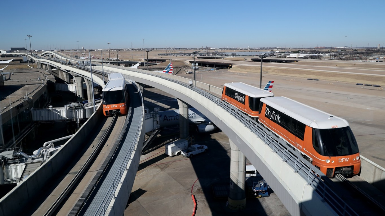
I would place the rail line tunnel and its station along the east side of the existing BL Airport station. For access to the airport terminals, there would be an elevated rail people mover system similar to the Skylink at Dallas-Fort Worth Airport, which would access the BL station, the new NSRL station, the car rental complex, and all the airline terminals:

Screen-Shot-2022-04-18-at-8.11.00-AM.png
I would build the NSRL station directly under Central Parking, so it is a walking connection from all terminals.

At Charles-de-Gaulle, the TGV station is directly under T2, easy walking connection for most flights. (almost the center of the image below):
1691782415452.png
 
But the regulations and engineering involved in tunneling under active airplane taxiways, that's beyond me.
This is comparing apples to oranges, but I believe Shanghai built its subway lines 2 and 10 under the runways of Hongqiao Airport while it was in operation the whole time:
Screenshot_20230812_051816_Amap.jpg


(Line 10, the purple line, has stations at both terminals, but that's because of the design of the airport where the two terminals are separated by the runways.)
 
Nothing specific. You could probably go under the East Boston Greenway and then under 1A as needed, but this runs into your second point.


I think these goals are fundamentally at odds. The Logan terminals are out of the way enough that diverting the entire connection through the heart of the airport probably adds enough time to the trip (not to mention the additional tunnelling costs) to degrade the ride for the riders who aren't going to the airport, as well as losing a potential East Boston station. Given that most people riding will be going to places other than the airport, I don't think diverting the entire tunnel is the right approach here. Especially if "no transfer" is a hard requirement. Most other airports with rail connections (at least that I'm aware of) make do with a single station and then some sort of people mover system to move people from the station to the terminals, like Newark. The only other places that have a mainline rail station per terminal (thus meaning no people-mover needed) would be ones like Heathrow and Philadelphia, both of which put the airport on the terminus of a line instead of on the line itself. You could probably put a station under the parking garage here and provide a short-ish walk for everyone to their terminals, but I think if we're considering some sort of NSRL2, we've got to consider that some sort of people-mover from Airport station has already been built, and would probably be the cheaper alternative.

Stepping back a sec, if the priority of NSRL2 is to connect the Providence and Newburyport/Rockport lines, the busiest North/South lines, then I'd say my original proposal can do that. Expand the Providence ROW to have a couple of tracks under the Southwest Corridor Park, starting around Roxbury Crossing. From there, the new tracks descend to go under the current ROW, and there are a few paths to eventually curve into the new Back Bay. That's admittedly long. My proposed Dartmouth/Third St tunnel is about 3 miles, and this extra one to connect in the Providence Line would add another 1.5 miles. So that's cumbersome, but that's still gotta be cheaper and easier than a cross harbor tunnel.

Second, I can see some of the merits of a cross harbor tunnel. If we do that, why not build a short spur to the airport, with a new train terminal right under central parking at Logan? The mainline could have a regional rail station some other place in Eastie more useful for residents, like around Maverick. I suggest this because if the cross-harbor tunnel is only connected to the Newburyport/Rockport line, that will be an extremely underutilized tunnel. I've only seen discussions of having that line run every 15 minutes, with some of those trains still going to the surface North Station. That leaves tons of space in the cross-harbor tunnel for trains going to/from a Logan spur.

Y'all are right that a people mover from the BL would be a great improvement for people getting Logan on the T, and that would still be important if we built a regional rail station right in Logan. But if we were building whole new public transportation lines, like a cross-harbor tunnel, we can build it to actually take people where they're going.
 
Boston Planning & Development Agency planners, as seems to be their wont (sorry, folks - if the shoe fits...) threw a bunch of wild-eyed, long-term transit visioning into the latest East Boston rezoning study, including this crayon of alternatives for extending the Blue Line:

1694201352599.png


FYI: If you see the map in context (page 87 of the PDF, 169-170 of the printed doc: https://www.bostonplans.org/getattachment/64e6e176-1936-46e7-abb2-bf131fdca6fe), it's clear that crayon is options, not a vision for an octopus-like line.

Other notable ideas and/or intent expressed about use of streets in the area:
  • advocating for using the 1A corridor as some kind of additional bus highway and adding Revere<>Eastie<>Chelsea bus service (PDF pages 80-83)
  • Redrawing Day Square to put the SL3 and T104 on dedicated surface lanes (PDF pages 51-53)**
  • Fairly lengthy bus lanes up Meridian (PDF pages 45-50)
  • A whole mess of cycling improvements (scattered throughout, PDF page 34 and onwards)
**Wouldn't that run afoul of the vehicular access detailed in the 355 Bennington St. project presentations from last year? https://www.bostonplans.org/projects/development-projects/355-bennington-street
 
That map is exactly what I would expect to see when considering potential Blue Line extensions - going via Kendall and via Storrow are the obvious options, and Watertown/Newton Corner and Longwood/Brookline Village are good anchors. Ambitious, for sure, but actually very sensible routings for a crayon map.

I love that proposal for Day Square. It puts transit at the center of everything and gives the area much better access to Seaport/Financial District, Chelsea, and Everett.

1694210007057.png

1694210068683.png
 

Back
Top