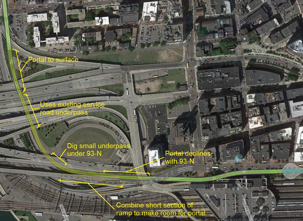
Green Line Reconfiguration

I can't see the map since it's asking for a login. If you're saying swing +1 blocks out instead and ride Lincoln instead of Hudson you slam straight into a tunnel wall before reaching the corner of the building at Essex. And then the next block past Essex to Summer is blocked by 1) the Exit 20 collector/distributor tunnel off to the side underneath Lincoln St. Green, and 2) the Red Line under Summer St.

Unless you're attempting davem's routing around the South Bay minefield the only injection point across between Kneeland and Summer is Essex from the tip of Chinatown Park. There is no give whatsoever on those 3 blocks, and no give anywhere north of Essex. Just be thankful there's more than one trajectory for reaching that tip of Chinatown Park in the first place.

Also...when you're talking 1-on-1 comparisons between streets with barely 5-10 ft. difference in width, you're within the margin of error that the actual-factual Phase III BRT tunnel needed to bake in for turn radius around the curves on Essex. Essex, which is narrower in parts than Hudson. So we're really, really overrating how big an issue that's going to be on a 2-track trolley tunnel. Slipping past exactly 500 ft. linear feet of street where buildings happen to frame both sidewalks at the same time isn't a tall order. That new building on the corner of Kneeland leaves a fatter foundation-to-foundation width than the Green Line in front of the Omni Parker House or the Tremont Tunnel the first 2 blocks south of Boylston.

Is the transitway bus turnaround above or below the central artery tunnel? If it is above it, are there reasons why the Davem routing could not portal out from underground south of Kneeland Street and travel at grade below the South Bay ramps and over passes and then portal back underground at Marginal St?
 
The CAT is way too shallow at Kneeland street to allow for a portal there. The Portal would have to be farther north in the middle of Atlantic Ave, and that would mess up the taxi stand and access to the bus terminal.
 
Is the transitway bus turnaround above or below the central artery tunnel? If it is above it, are there reasons why the Davem routing could not portal out from underground south of Kneeland Street and travel at grade below the South Bay ramps and over passes and then portal back underground at Marginal St?

Above northbound at the loop. Literally; 93N is directly underneath the tunnel all points it's on Atlantic. But to cross southbound the next block over it has to slip under the highway. There's a dramatic depth difference between 93S under Surface Rd. and 93N under Atlantic Ave.


For reference the southbound lanes of 93 and the south tip of the Exit 20 collector/distributor past Lincoln ride inside the retrofitted 1950's Dewey Square tunnel. Construction of that tunnel 6 decades ago bulldozed the southern end of the Red Line's empty upper-level tunnel (the one used by the Winter St. concourse and office space at Downtown Crossing).

The northbound lanes of 93 are all-new CA/T construction that's deeper than the Dewey Square tunnel; the Transitway slots on top of it under Atlantic Ave. At the Summer intersection, where the Silver platform is centered, BOTH Silver and Red pass above 93...with the Silver level being cobbled together some-old/some-new from various chunks of the old Red fare lobby level.

This is why the trajectory has to be so precise and locked-in on Essex block. Essex between the park and Atlantic Ave. is precisely long enough (by design) to change depth between under 93S and over 93N, then level out in time to curve into the station. (And you wonder why this thing projected so dog-ass slow as BRT!)

silverlinetunnel.jpg


For portaling, even though 93S is the 'relatively' shallower tunnel it's still a steep and very long incline to go straight from surface level to underneath. You might be able to do that from the Hudson trajectory if you took the entire two-block linear length of the park as your incline space. It would be a barf bag ride for how long that steep grade would have to run, though. Forget about portaling on any other alignment; you simply don't have enough running room to get from surface to under 93S in less than 2 blocks. For example, if you tried to go surface on Essex you'd have to portal-under at roughly Harrison Ave.; see any plausible room for that here?


And upon further reading, the tunnel mash-up on Atlantic would almost certainly preclude any thoughts of hooking direct into the bus loop via davem's Atlantic Ave. trajectory. 93N is rapidly ascending to the surface on that steep, steep highway portal incline so you simply run out of room trying to plow south straight off the loop. Can't get any further than Beach St. before 93 starts coming up through the floor, and the Beech-Kneeland block is abutted by the South Station building and tall buildings across the street so there's no place to turn out and sidestep all that's coming up below. That routing's out.


You're really, really locked in at Essex via tip of Chinatown Park as the one and only way into the Transitway. All of the negotiables are west or southwest of there on the path you take from Boylston to Chinatown Park.
 
Last edited:
^ There's no reason you can't cut a portal into atlantic ave south of beech st. The bus station (which abuts on the eastern side) is several stories above the ground, and what reaches street level is just a staircase and an elevator shaft. If you rebuilt those north of beech you'd actually be improving connectivity between the bus terminal and the other modes. At ground level its all just train tracks anyway. You could even keep the green line in a box tunnel partly above grade level and replant that little strip of lawn in front of the bus terminal because green space if necessary. Getting across the stub of atlantic once you're south of kneeland is a little tricky but not impossible.

Would definitely rather fight that 1/4 mile and then luxuriate in the wide open spaces of the spaghetti bowl, if the alternative is the duck and weave under the dewey square tunnel (not to mention hudson st.)

No...you can't. 93 starts rising from below before you even reach Beach. You're completely out of vertical room before you have first chance to make a lateral turnout. The train station entrance on Atlantic is where the entirety of the loop is, the loop is over before East St., and south of East St. the entire brick plaza is eaten up by 93N + a merge ramp converging on the steepest grade of the C/AT. This is what's underneath the corner of Atlantic & East. Pan Street View around to see how steep it is. You never reach 3 clicks over to Beach for first attempt at a turnout because 93 has already punched through the tunnel floor.
 
To make this a little easier, here's a map showing where the wiggle room exists:

vddf9s.jpg


Red, Orange, Green, Transitway + loop, and Tremont tunnel shown. The locked-in Chinatown Park-Essex St. trajectory is shown. Dashed black lines are highway tunnels (note that 93S gets fatter north of Essex for the Exit 20 collector/distributor).

The shaded area is all the conceivable universe of wiggle room you have for getting between Boylston and Chinatown Park. This (see p. 27) is the T's last attempt at finding a SL Phase III routing before they threw in the towel; doc also shows the tortured evolution of the project as they threw other considered alignments on the scrap heap.

Have at it, and keep in mind that this involves slipping under the 93S tunnel, over 93N, and that the grade difference between the two takes running room across the midblocks. So also watch the severity of the angles because the tip of Chinatown Park has to act as the funnel that threads all trajectories into the locked-in path for slipping between other tunnels.

I know I have pitched this many times before, but....

Pretty obvious that you go deep bore under Essex/Boylston, from Chinatown Park to mid-block around the Public Garden on the Green Line. You do not try to turn Downtown on the Green Line; this is a West (choose your poison which branch) to Seaport branch. Mid-block station under Boylston Street between Boylston and Chinatown. Both Green and Orange connections. Both become downtown transfer stations, spreading the load from the original four.

Tunneling is facilitated by the elevation changes. There is a natural rise as you cross the old Shawmut Peninsula, so the elevation makes going under the Orange and Green Lines (both shallow) much easier (you minimize the tunnel pitch). Mid block between Charles Street South and Arlington on Boylston is the site of the old Green Line portal (median on Boylston), so you come up to join that tunnel from underneath there and merge to go west.
 
You could do that, but. . .

1) $$$$$$$$$$. We already know from SL Phase III that Essex + shivving a station under Essex @ Washington + the Public Gardens are mitigation nightmares. And that Phase III blew out its costs because it required twice the tunneling and twice as many stations to build with Boylston Under on the direct east-west trajectory. Are you ready to spend $3-4B instead of $1-2B?

2) The primary load relief this serves is on the transfer dance on/off the Red Line SS<==>DTX<==>Park and Orange DTX<==>State. It currently takes a double-transfer to get to downtown, northside commuter rail, and Back Bay. And it's those transfer platforms that are lengthening dwell times to the point where the lines are ceasing to function over time. This routing doesn't help that nearly enough by omitting:

  • Direct Blue transfers. Must transfer @ Chinatown to Orange, then @ State to Blue. Or Red @ SS, Blue @ Charles. No crowds come off the two overloaded heavy rail lines; you just get a light fluffing-of-pillows on which stops Orange or Red get slammed for the double-transfer. For 50-year growth and all the Seaport, Urban Ring, and NSRL are going to throw at the system, you must defuse the congestion bomb hitting Orange and Red at the downtown transfers. Picking routings that omit one entire heavy rail line from a transfer doesn't do nearly enough to stave off that looming problem.
  • Directs to northside commuter rail and North Station environs. Must transfer @ Chinatown to Orange or reverse direction at nearest Green westbound station. OK...that's one less transfer than it took before via Red, but now you're dumping more people on Orange and exacerbating the crowding with the Blue double-transfer. This build predates the most optimistic design-build timetables for the NSRL, because this is arguably an ironclad prerequisite for distributing the loads NSRL will throw at SS and the Seaport. So the loads on Orange in the meantime are a real and vexing problem that don't have secondary relief coming before they've already taken their toll.
  • Tolerable travel times to Northpoint, GLX, Sullivan, and first stops east/west on the northern Urban Ring by distending the transfers way south and west requiring a second post-transfer pass through a busy gauntlet of downtown stations. Lesser concern than the above two bullets, but throw that on the pile. Green is slow enough through Park and GC, but now you're going to make people go up-and-over to change platforms at Arlington or a new infill stop, and wait X many trains for one that isn't turning at GC or NS? That might be even slower than doing a Green-Orange-Green double-transfer @ Chinatown & NS when factoring in wait times for a trolley that isn't short-turning, and smart riders will instinctively know to pull up real-time tracking on their cells when the train is between SS and Chinatown to make the call: "Bail to Orange; there's a glut of back-to-back B's and C's coming in from Kenmore." That does nothing to help Orange loads because there'll be whole pulses of transferees at Chinatown when Green is unfavorably out-of-sync. And out-of-sync is what you get the further westward off-center you drag the transfers.

3) Back Bay Station is an identified constituency for the Seaport. It's why they want to throw out that showpiece Track 61 DMU dinky pinging between BCEC and Back Bay Station. Too many BCEC attendees are shuffling between there and BBY. By throwing them on Green you're throwing them at Copley Jct. and wholly inadequate capacity. To fix this you have to be prepared to build the Park Square Subway off the other half of that GL junction or you're going to cripple the west end with paralysis at Copley Jct. trying to distribute those crowds at Copley and Prudential. OK...now you have tripled the amount of tunneling needed to 'fix the glitch' permanently, but are still double-transferring to get to Blue and slamming Orange to overload in the pre-NSRL interregnum to reach North Station, and doing a cumbersome reverse move to get up Green for Northpoint, GLX, and Urban Ring north. So it's not really a total fix, just a 'good enough' fix at thrice the price.


4) The Green Line can't absorb another spacer between Arlington and Boylston. It's slow enough as-is, and more people are going to be reliant on this slowest section if you distend the transfer for getting Science Park-and-out further west. Have to seriously consider whacking Arlington or Boylston to keep things moving.


5) Can you prove Kenmore is THAT big a draw that the one-seat from due west trumps all the distortion with the transfers downtown? And what's the empirical evidence for this since the Blue Book p. 14 figures skew overwhelmingly to Back Bay station and Downtown as to where the ridership is distributing? How strong is that empirical evidence to justify spending 2-3x as much in tunneling and station costs?

F-Line, Why must this line provide a direct transfer to Blue? Seaport to Blue is covered by Silver Line Gateway --> Airport Station.

I understand the CURRENT indication of BBY demand -- but what to we know of near Western suburbs (Green Line Serviced) to Seaport (with all that office construction). You won't see it today because it is such a pain (two transfers) -- this would be single seat ride or one transfer at Boylston. Blue book does not tell all, it only tells what is realistic TODAY.

You could do this and also activate the Tremont portal to BBY, on to Huntington; or also to Washington Street if you like (just not your great circle route around Chinatown) -- taking a line off of the Boylston Street subway -- eliminating your bottleneck.

Also, I understand the complexity of the Boylston/Chinatown Station. It would not be cheap. But you are still facing a big part of that bill to rehab Boylston Station -- historically significant, and desperately needing an ADA upgrade -- plus trying to activate the Tremont portal platforms -- all of which is 125 years old. Never going to be cheap (and probably a Longfellow Bridge type historical rebuild with tools and techniques no one knows how to do anymore!).

Next?
 
This will be either mindbogglingly stupid, or, perhaps, a bit less than stupid:

4lXAPyb.png


> Box tunnel under Herald
> Narrow cut under Albany and short bit of 93 spaghetti on alignment into...
> Re-purpose underutilized Airport HOV lane under Fort Point Channel
> Connect into Silver Line tunnel - this connection is most difficult because it would need to pass over the 90 Channel Tunnel, but the area is so clear that there must be at least one viable routing
> Essex Street stub-ending becomes a GL turnback

Benefits: 1) Utilize existing infrastructure, 2) Eliminate Seaport branch "dead end", 3) Enable better connectivity from the heart of the Seaport to the OL (with single-transfer connection to BBY) 4) Better stop location to serve Ink Block developments, with logical Seaport connectivity

Drawbacks: Looks stupid and circuitous.
 
Keep in mind my routing through the spaghetti was mostly on the surface.
12308714873_77cca70087_b.jpg
 
I've also wondered about DaveM's routing as an alternative to digging up Hudson St. As a slight alternative to his alignment what about the following (sorry drew a map using Dave's image but I don't know how to upload it):

1. As Dave has portal up to the surface where he does after the Marginal St. dig and then take the service road to go under I-93S.

2. Instead of continuing straight to dig a small underpass underneath I-93N (as Dave has in his map), turn left and climb the "dirt mound" in the middle of the spaghetti bowl.

3. Begin an aerial structure at some point on the "dirt mound" so that the green line would pass over the South Station connector and right by the south east corner of the building on the corner of the old Edison plant property that Google Maps calls the Massdot District 6 Headquarters.

4. Descend onto the eastern side of Atlantic Avenue in front of the bus terminal and continue to use this eastern side of Atlantic Avenue until you can descend down for a portal into the bus loop.

Now I realize in this alignment you are trading an aerial structure for a tunnel up Hudson and I also realize that this would require a wholesale rethinking of the access and egress to the bus terminal. However, would it be possible if we were willing to be creative about how we thought about that eastern side of Atlantic Ave? If so, then maybe upon study this alignment would cost less and aught to be considered as part of the alternatives analysis.

As for this section of Atlantic Ave I think anyone who has spent some time in that area would agree that we aren't really messing with a lively and irreplaceable urban environment. Frankly it is kind of a throw away from a place making perspective. If this project forced a reconstruction of Atlantic Ave so that the entrance to the bus terminal was closer to the train station that probably wouldn't be a bad thing. As had been said before you have some room to play with because the bus terminal itself is an elevated structure and isn't really accessed from the street level anyways, so just move the stairs and the elevators accordingly.

Thoughts?
 
Keep in mind my routing through the spaghetti was mostly on the surface.
12308714873_77cca70087_b.jpg

Still doesn't work because the Transitway is out of room at East St. for continuation down the block to Beach & Kneeland because of the fast-rising level of 93N underneath. Everything else is probably doable...you just can't inject at the bus loop because 93 and the adjacent merging ramp (which spreads the highway across every inch of the SS bus station's front lawn) is literally bursting through your tunnel floor.

You can illustrate this by going on Google Maps, taking the little Street View guy, and dropping him by the front door of 2 Financial, which is roughly center of the bus loop: https://goo.gl/maps/4difFDN1bqN2. Those support pilings in the ramp median 3 clicks up are the East St. intersection, and by panning around you can see what a wicked grade this is on. From the pilings on out to daylight 93 has ascended too high up for an upstairs tunnel, and spread too far wide with the ramp and ramp wall to plop anything on the bus station lawn.


That leaves the block prior to East as the only way in: Essex, which is how all the official plans do it.
 
I've also wondered about DaveM's routing as an alternative to digging up Hudson St. As a slight alternative to his alignment what about the following (sorry drew a map using Dave's image but I don't know how to upload it):

1. As Dave has portal up to the surface where he does after the Marginal St. dig and then take the service road to go under I-93S.

2. Instead of continuing straight to dig a small underpass underneath I-93N (as Dave has in his map), turn left and climb the "dirt mound" in the middle of the spaghetti bowl.

3. Begin an aerial structure at some point on the "dirt mound" so that the green line would pass over the South Station connector and right by the south east corner of the building on the corner of the old Edison plant property that Google Maps calls the Massdot District 6 Headquarters.

4. Descend onto the eastern side of Atlantic Avenue in front of the bus terminal and continue to use this eastern side of Atlantic Avenue until you can descend down for a portal into the bus loop.

Now I realize in this alignment you are trading an aerial structure for a tunnel up Hudson and I also realize that this would require a wholesale rethinking of the access and egress to the bus terminal. However, would it be possible if we were willing to be creative about how we thought about that eastern side of Atlantic Ave? If so, then maybe upon study this alignment would cost less and aught to be considered as part of the alternatives analysis.

As for this section of Atlantic Ave I think anyone who has spent some time in that area would agree that we aren't really messing with a lively and irreplaceable urban environment. Frankly it is kind of a throw away from a place making perspective. If this project forced a reconstruction of Atlantic Ave so that the entrance to the bus terminal was closer to the train station that probably wouldn't be a bad thing. As had been said before you have some room to play with because the bus terminal itself is an elevated structure and isn't really accessed from the street level anyways, so just move the stairs and the elevators accordingly.

Thoughts?

See prior post. Atlantic is blocked all points south of the existing bus loop and every inch of width sidewalk to bus station building by 93N, which is spreading way wide and rising way fast from the depths out (or rather, in from) South Bay portal. That's why the area of wiggle room I shaded on the map a few posts up doesn't include Atlantic. You have no way in from south of the loop.

And you also have no way in from the north because of the mash-up of double-wide 93S + Exit 20, and the converging Red Line to the north. Which leaves only west/southwest, and a trajectory that slips UNDER southbound and OVER northbound with enough running room between them to change grades from slipping under to slipping over. That's why on the map the orange-shaded area of wiggle room emanates from the corner of Chinatown Park @ Essex like a big lawn sprinkler. Anything in the lawn sprinkler's spray is negotiable depending on how much pain you want to take on. But nothing clear of the spray from that 'nozzle' is physically possible, even with a tactical nuclear strike, because it's set by 93's depth and width. And I don't just mean 'too hard to try'...I mean, bloody 1000% physically impossible without re-digging the Big Dig at South Bay portals.
 
^ F-line all this assumes that the GL has to be 100% below existing grade on atlantic. Surely its at least conceivable that a box tunnel that hugs the west-most track at SS could get through, even if its 90% above grade at kneeland.

...you can't really mess up the taxi pickup area because nothing formal exists now - its a free for all and can only be improved. You aren't going to make the streetwall on the SS / bus station side any worse than it is now.

And yes, you STILL probably have to find a way to get across the stub of atlantic south of kneeland, but if you're willing to reconfigure the bus road (and potentially willing to raise Atlantic to have an intersection with the bus road) then you're out of "impossible" and into "complex". And then you can just compare 'Atlantic ava' complexity against 'hudson / essex complexity and pick your preference.

And re: the highway incline - you DO have some room to work with, to the extent that at Dewey square the red line tunnel is squeezed between the SL and the highway. So if you start an GL/SL incline right at the station, the grade can be less than that of the highway itself, because you have a ~15ft 'head start' because of the gap for the RL, and you can still get to 'even' by the time you hit kneeland (even if your box tunnel - or plain old open air portal - is 95% above sidewalk level by that point.


tl;dr I still maintain that nothing on Atlantic Ave. is 'engineering impossible' - its just a matter of deciding how much else you're willing to mess around with, esp. building a box thats partially above grade.
 
I should have said that as well, I conceived of a box or some sort of at grade solution with a portal as far down Atlantic as it needs to be. I recognize that this causes a whole new reimagining of how Atlantic Ave looks in this area but that might not be a bad thing as there is a lot of room for improvement there.

I'm not saying that it is preferable to a Hudson St. Alignment; just that I'm not following why it is impossible rather than a bit complex. If it's somewhat feasible it might also be worth an analysis to see how it prices vs. Hudson and Essex.
 
^ F-line all this assumes that the GL has to be 100% below existing grade on atlantic. Surely its at least conceivable that a box tunnel that hugs the west-most track at SS could get through, even if its 90% above grade at kneeland.

...you can't really mess up the taxi pickup area because nothing formal exists now - its a free for all and can only be improved. You aren't going to make the streetwall on the SS / bus station side any worse than it is now.

And yes, you STILL probably have to find a way to get across the stub of atlantic south of kneeland, but if you're willing to reconfigure the bus road (and potentially willing to raise Atlantic to have an intersection with the bus road) then you're out of "impossible" and into "complex". And then you can just compare 'Atlantic ava' complexity against 'hudson / essex complexity and pick your preference.

And re: the highway incline - you DO have some room to work with, to the extent that at Dewey square the red line tunnel is squeezed between the SL and the highway. So if you start an GL/SL incline right at the station, the grade can be less than that of the highway itself, because you have a ~15ft 'head start' because of the gap for the RL, and you can still get to 'even' by the time you hit kneeland (even if your box tunnel - or plain old open air portal - is 95% above sidewalk level by that point.


tl;dr I still maintain that nothing on Atlantic Ave. is 'engineering impossible' - its just a matter of deciding how much else you're willing to mess around with, esp. building a box thats partially above grade.


Let's do some illustrative math here. . .


93 North tunnel height/depth

  • Tunnel dug to maximum 100 ft. depth at the top surface to slip below the Red Line. Location of maximum depth: Summer/Atlantic intersection in the plaza across from the Federal Reserve, where it crosses the Red Line at a 90-degree angle.
  • Minimum depth at top surface is the portal, 3 ft. above street level.
  • It is 1800 ft. from portal to deepest point, for a 5.7% average grade.
  • Dimensions between top surface and bottom surface: 16 ft. interstate-standard vehicle clearance + 1 ft. extra clearance for roof-mount objects + 3 ft. roof slurry wall + 3 ft. floor slurry wall. 23 ft. minimum structural height.
  • Caveats: while slurry walls are known to be 3 ft. each, those were primarily for the sides which have nothing else but tiles mounted on them. Roof and floor may be thicker. Unknown extra allowances also needed on roof for ceiling tile mounts + electrical/misc. conduits, and (moreso) on floor for roadbed base + pavement. Figure conservatively a 25 ft. minimum structural heigh.
93 North tunnel width

  • 93N is at minimum width--the exact width of Atlantic--on Atlantic's its narrowest pinch between the SS building walls and the One Financial building walls.
  • 93N is at its maximum width south of the corner of the trainshed, where the adjacent onramp tunnel fills out the entire plaza and runs up to the bus station wall.
  • 93N starts widening at the SW corner of the old South Station building, where the accel lane from the onramp is merging in a solid white line. Back to the trainshed corner it's a fattening striped line.
  • At mid-intersection East St. the 93N onramp divider wall begins and 93N has steepened to maximum grade.

Silver Line tunnel
silverlinetunnel.jpg

  • 60 ft. tunnel floor depth, level from the loop and through the SS inbound approach.
  • 16 ft. tunnel clearance (I don't know what the Transitway actually is, so I'm going by the Urban Ring DEIS).
  • Not constructed with slurry walls, so probably thicker than the 93 tunnel. Assume for argument's sake the same 3 ft. thickness top and bottom.
  • Pavement pack would be same extra allowance, and assume ceiling allowances not much different. ~23-25 ft. total structural height.
  • The structural top of the tunnel is 35-37 ft. below street level.
  • The structural bottom of the tunnel is 63 ft.


Silver positioning


  • Platform is perpendicular to Red downstairs, but slightly off-center to the south. They form a "T" shape if overlaid on top of each other.
  • South tip of SS platform is at the NE corner of the tower portion of One Financial, 100 ft. from the Atlantic @ Summer crosswalk.
  • Bus loop ends 350 ft. south tip of platform at corner of the SS trainshed.
  • Depth from loop through station is level.

Silver vs. 93

  • At 5.7% average tunnel grades, the 93N tunnel structural bottom has reached same 35-37 ft. depth as the structural top of the Silver Line level in 615-650 ft. Or roughly the garage of 751 Atlantic.
  • At 5.7% average tunnel grades, the 93N tunnel's structural top has cleared the Silver Line level's structural bottom of 63 ft. in 1105 ft., or roughly the SW corner of the trainshed.
  • The Silver Line loop ends immediately before the SW corner of the trainshed. It cannot be extended 1 inch further south.

Injection points

  • We know that the loop is 350 ft. from the platform, and that vehicles must be level in time for the platform.
  • We also know that 93 has spread out to maximum width across the SS plaza by the time it hits the loop.
  • The steepest grade on the Silver Line in the current Transitway is 5.7% at the portal. The steepest grades proposed on Phase III were 6.4% and 8.2% (rejected as infeasible).
  • Green Line design standards permit 8% grades on new construction: http://greenlineextension.eot.state.../Topics/SchematicPubDesignGuidelns_042809.pdf. There are legacy grades, such as Comm Ave. near Summit Ave., that exceed this. But new construction cannot.
  • The most severe grade on rapid transit adjacent to a platform is Science Park, which levels out 100 ft. from the platform tip.
  • SP is on an upward incline to an elevated station, however, so safe braking distance is going to be much longer when platform tip is at bottom of severe downgrade.
  • A 4-car Green Line consist is ~300 feet long. If you want to guess on a safe braking minimum after 8% grade being all four cars sitting level before the platform tip (which seems way too short), then you must be done inclining by the wall of the current loop.
  • To incline down 60 ft. below surface at 8% maximum trolley grades you have 750 ft. of running room to work with to get level.
  • . . .meaning, you must start your incline no later than dead-center Kneeland intersection. The 93N structural top is less than 20 feet below street level here.


Unknowns: changes in grades. We're going by averages.

  • 93 is less-steep at the bottom where it's leveling out, more steep in the middle by the ramp, slightly less steep at top by the portal. How much less than 20 ft. is the top of the tunnel actually at by Kneeland?
  • The onramp that takes up the SS front lawn has a portal 100 ft. further north than the mainline. Is there a grade difference here?
  • The tops and bottoms of the trolley incline wouldn't be 8% rigid. They would start and end smaller. How much extra padding is needed on your shortest allowable incline length? Do you have to push it south of Kneeland?
...and then throw the fudge factor in:

  • tunnel roof and floor thicknesses unknowns.
  • allowable stopping distance before platform unknowns taking a 4-car train off an incline. Does that mandated stopping distance go longer with severity of incline?
  • unknowns of how much spacing needs to go between tunnels inclining at different rates through the given geology of that block.
  • impacts to the Big Dig tunnel from digging upstairs, especially mitigation to things like those problematic ceiling tiles.


^^^You are already on your last 350 ft. of wiggle room between the tightest humanly possible fit on known-knowns before tabulating the unknowns.


Questions:

  • Why are you choosing the lowest-odds possible trajectory that must hit a hole-in-one to work at all?
  • To what advantage is the lowest-odds possible trajectory over others?
  • To what cost effectiveness is the lowest-odds possible trajectory over others? And don't say "because part of it runs on the surface" when you're building two portals, and choosing the maximally difficult and lowest-odds possible tunneling for the longest single segment of the extension.
  • How much longer do you want to wait to build the lowest-odds possible trajectory for all the extra engineering impacts that would have to be studied in triplicate?
  • How do the low odds and high overhead on the schedule help get the second-most important and badly-needed (after Red-Blue) transit project in the city built more quickly than any other trajectory? And don't say "because some of it is on the surface" because raising difficulty level to the outer limits on this trajectory AND building a second portal pretty thoroughly shred any design time savings of the surface routing. A surface routing that cannot be locked-down until you know where your portal is relative to Kneeland.


You do realize this isn't a Crazy Transit Pitches exercise in 2D-drawing the most improbable tactical nuclear strike that meets the '¡technically correct is the best kind of correct!' definition of "possible".


We kind of need to get this built. Like...now. So if the T had to come to grips with the failure of SL Phase III re: how its own arbitrary design choices harmed the feasibility of their chosen routing...so do any offered replacements on replacement modes. Trying to make battles of will out of the intentionally most difficult isn't going to fare any better next time than it did last time.


So...applied knowledge? Learn from history? Anyone? Anyone?
 
To make this a little easier, here's a map showing where the wiggle room exists:

vddf9s.jpg


Red, Orange, Green, Transitway + loop, and Tremont tunnel shown. The locked-in Chinatown Park-Essex St. trajectory is shown. Dashed black lines are highway tunnels (note that 93S gets fatter north of Essex for the Exit 20 collector/distributor).

The shaded area is all the conceivable universe of wiggle room you have for getting between Boylston and Chinatown Park. This (see p. 27) is the T's last attempt at finding a SL Phase III routing before they threw in the towel; doc also shows the tortured evolution of the project as they threw other considered alignments on the scrap heap.

Have at it, and keep in mind that this involves slipping under the 93S tunnel, over 93N, and that the grade difference between the two takes running room across the midblocks. So also watch the severity of the angles because the tip of Chinatown Park has to act as the funnel that threads all trajectories into the locked-in path for slipping between other tunnels.

The biggest problem I see with the Silver line waterfront is that it only connects to the rest of the MBTA at south station. As a result nearly all of the large companies with offices in the Seaport pay to run shuttles from North Station, State Street and other points downtown to their offices in order to get North Station, Orange, Green, and Blue line commuters to work.
With the objective to connect the other subway lines to the Seaport would it be short sighted or cost effective to extend a bus portal up Essex Street (instead of running the Green line into the Transitway)?

After the Silver line turns right into the new Essex Street extension the transitway would rise up to the surface instead of lower under 93 SB. From there the bus route could run counter flow down Essex / Boylston with stops at Chinatown (Orange) and Boylston (Green). The route could then turn on Tremont (either right or left) go around the block and return on Essex to the portal. To connect to Copley Sq, the bus route could also be run counter flow down Boylston, turn at Clarendon and then return down St James Street counter flow towards the portal. This would create a direct connection between Copley Sq and the Seaport/ Convention center / Airport.

The Blue line connection to the Seaport would be from the new Silver line Gateway at the Airport station.
 
F-Line, Why must this line provide a direct transfer to Blue? Seaport to Blue is covered by Silver Line Gateway --> Airport Station.

100% of the people who use Blue go only to Logan? I wasn't aware of that seeing as how Maverick is far and away the highest-ridership stop after the 3 downtown transfers and does >1.3x the daily boardings. Or Wonderland that does 82% of Logan's daily boardings. What Silver Line route serves those folks? Those people have, and all of Eastie and Revere in-between (and Aquarium) have to do the double-transfer and hit Orange or Red.

Blue Line ≠ Logan.

I understand the CURRENT indication of BBY demand -- but what to we know of near Western suburbs (Green Line Serviced) to Seaport (with all that office construction). You won't see it today because it is such a pain (two transfers) -- this would be single seat ride or one transfer at Boylston. Blue book does not tell all, it only tells what is realistic TODAY.
Then present your empirical evidence about TOMORROW.

This isn't a Crazy Transit Pitches build 50 years out; it's Take 2 at a project that was first attempted 10 years ago and should...officially...have been open by now. But it failed at chosen mode, routing, and cost. And needs to be revised and re-engineered to address all 3 of those fatal issues that upended it. It did not revert to figment of imagination; we need to find a way to get it built relatively soon on a buildable routing, or congestion is going to choke downtown. That is a known.

So tell us what you know about the unknowns as they diverge from today's Blue Book on a project that was scheduled to be built 10 years past, and why those differences justify building twice the tunneling at twice the price.

You could do this and also activate the Tremont portal to BBY, on to Huntington; or also to Washington Street if you like (just not your great circle route around Chinatown) -- taking a line off of the Boylston Street subway -- eliminating your bottleneck.
So answer again...why are you building 2-3x as many tunnels and creating redundancies to get this done? Cost matters. This isn't an "if I had infinite money" thinkpiece. SL III failed in part because it passed up too much available infrastructure for creating too many tunneling feet of redundant infrastructure and destroyed infrastructure that had to be rebuilt.

If that was fatal to the real thing, you have to explain why doubling the tunneling cost (and potentially then some later) avoids the same fate.

Also, I understand the complexity of the Boylston/Chinatown Station. It would not be cheap. But you are still facing a big part of that bill to rehab Boylston Station -- historically significant, and desperately needing an ADA upgrade -- plus trying to activate the Tremont portal platforms -- all of which is 125 years old. Never going to be cheap (and probably a Longfellow Bridge type historical rebuild with tools and techniques no one knows how to do anymore!).
How is building a whole new level of Boylston comparable to dropping in elevators on the current level either behind the stairs or at the far tips where the old second entrances used to be? How does it require "techniques no one knows how to do anymore" when Park St. is just as old, has the same structural beams and ceiling arches as Day 1, when Boylston's walls were just blasted with paint guns about 8 years ago (for the umpteenth time over the original tile still buried under there), had modern lighting and drainage ducts installed, and had its headhouse sandblasted and restored. Historic preservation means that level has to keep its dimensions and not have radical layout changes. It doesn't mean you can't fix the saggy stairs or move the 1970's-era electrical boxes behind the stairs to drop in elevators.

What tools and techniques no one knows how to do anymore? Explain. And explain why building a whole other level--which DID structurally foul it to historical concerns with various SL Phase III alternatives--avoids that now where it didn't with SL III. You want to make the biggest change to the station; you explain how that works.


Let's build this thing, already? In the real world...with some degree of efficiency.
 
The biggest problem I see with the Silver line waterfront is that it only connects to the rest of the MBTA at south station. As a result nearly all of the large companies with offices in the Seaport pay to run shuttles from North Station, State Street and other points downtown to their offices in order to get North Station, Orange, Green, and Blue line commuters to work.
With the objective to connect the other subway lines to the Seaport would it be short sighted or cost effective to extend a bus portal up Essex Street (instead of running the Green line into the Transitway)?

After the Silver line turns right into the new Essex Street extension the transitway would rise up to the surface instead of lower under 93 SB. From there the bus route could run counter flow down Essex / Boylston with stops at Chinatown (Orange) and Boylston (Green). The route could then turn on Tremont (either right or left) go around the block and return on Essex to the portal. To connect to Copley Sq, the bus route could also be run counter flow down Boylston, turn at Clarendon and then return down St James Street counter flow towards the portal. This would create a direct connection between Copley Sq and the Seaport/ Convention center / Airport.

The Blue line connection to the Seaport would be from the new Silver line Gateway at the Airport station.

Where are you going to portal up on Essex? The BRT tunnel width is the entire street building-to-building, so there's no way to pop up without closing an entire block to auto traffic and severing Essex as a thru street.

Click the link in my post that you quoted; it's got maps of every single portal the T ever considered in 10+ years of Silver Line design revisions. They all had to plow under Boylston to the west because Essex had no room and the depths of the tunnel didn't allow a rise to street level without a lot of extra tunneling. The convoluted portal lead tunnels were all so long and so far away from Boylston because of the starting depth, grades, and shortness of city blocks for getting an incline done without sharp curves interrupting the climb. There's a pretty good body of official-sourced engineering evidence explaining why things had to be how they were with the BRT alignments. They went through so many permutations there's not very little left to the imagination on what construction is possible the length of Essex using rubber-tire vehicles.
 

Back
Top