Biking in Boston

Maybe I'm wrong but this path seems somewhat useless until it connects under Park Drive to the Riverway Path...I'm sure its sort of nice for pedestrians.
Yes they discuss that in the article, the segment under Park Drive is being held up by the MBTA against the wishes of MassDOT, DCR, and Boston.
 
Yes they discuss that in the article, the segment under Park Drive is being held up by the MBTA against the wishes of MassDOT, DCR, and Boston.
Hard to believe the hold up is that the MBTA uses the space for track maintenance storage from time to time. This petty fiefdom crap is why we cannot have nice things in Massachusetts.

a MassDOT project manager wrote that the “Phase 2” trail segment under Park Drive had been put on hold “mainly due to the comments received from MBTA Operations (who use) this location frequently for Green Line track maintenance. There is no current design or construction schedule available for Phase 2.”


Happy to be corrected by someone that knows better than me, but you might be understating the significance?

It looks like it's been their staging location/access point for track maintenance lately.

It is a fairly long storage track right next to the portal to Kenmore and the central subway. It looks like they can get large trucks and heavy equipment in down there and transfer materials between maintenance train + storage area/vehicles. It's also mostly out of the way from the view of the public and has relatively limited residential abutters, which probably keeps pressure off about keeping what look to be big piles of ballast, ties, and tracks over there in recent years.

If I take a look at the Street View off the bridge, the 3 most recent images (2017, 2018, 2020) look like it's in active use for maintenance purposes, and the most recent overhead imagery shows something parked on the tracks.

I'm also not sure if there's any other convenient location for this sort of thing other than all the way out at Riverside, and if so, I'm not sure how detrimental it is to efficiency of maintenance to push it all the way out there.....but it seems like it could be fairly significant?
I believe that there are a number of other potential storage and access points along the ROW, particularly out near Brookline Village (it can be quite wide, and there are former industrial access points). The problem with using them is likely abutters. At Fenway they have no real abutters who will object. Move out into Brookline and even if one side is still quasi industrial, the other side is residential.
 
They use the Fenway pocket track because it's the closest area for staging for subway overnight work. There wouldn't be a nearly as convenient place further out.

That said, there's plenty of room underneath that overpass to accommodate the siding and a path. There were 2 former track berths under there for the ex-Sears Building's freight siding. The T just might have to shift the track a few feet since it's currently occupying the far/wall berth and would need to switch places to the inner berth. Not a big job; they just have to go on and do it.
 
Walking through Boston Landing today; don't love the unprotected bike lane (see the parked car in the lane), but the large raised x-walk is great, and will be nice to have cycletracks through the Allston Yards development next door.

Biking in Boston (1).JPG
Biking in Boston (2).JPG
 
Eyes On the Street: Chelsea’s Produce Distribution Corridor Gets Much Needed Bike and Ped Upgrades
IMG_8422.jpg

Chelsea – Pedestrians and bicyclists can now walk and roll along a brand new bike path and sidewalk on Beacham and Williams Street – a far cry from the corridor’s previous degrading asphalt conditions.

Before
road_conditions_2.jpg


After
IMG_8408.jpg


To be continued
IMG_8449.jpg

https://mass.streetsblog.org/2022/1...ridor-gets-much-needed-bike-and-ped-upgrades/
 
Minuteman Bikeway Extension Hinges on Upcoming Special Vote
nexus.png

Next month, residents of the Town of Bedford will decide the future of their town’s Minuteman Trail extension project during a Special Town Meeting, where a two-thirds majority vote is needed to move the project into construction.

The proposed 2.2-mile project would extend the Minuteman through Bedford from Depot Park to just the other side of Route 62/Concord Road, to the Town of Concord border, along a dirt pathway that’s locally known as the Reformatory Branch Rail Trail.

The project includes a shared-use path for the portion of the trail along Railroad Road, which leads to the Reformatory Branch Trail.
ReformatoryBranchLocator.png

https://mass.streetsblog.org/2022/10/06/minuteman-bikeway-extension-hinges-on-upcoming-special-vote/

This project has left me feeling conflicted for a long time. On one hand, it’s a win for improving micro mobility access. On the other hand, I personally love the Reformatory Branch Trail as is and it’s one of the few places where there is a natural, dirt, rideable path in the area.

It’s unfortunate that pedestrians, cyclists, pedestrians, and other micromobility users are always fighting each other for such a small slice of the pie, while car dominance continues in the overwhelming majority of transportation acreage.

One of the primary reasons why I love cycling is that it has the potential to decrease our species physical footprint and leave more of nature natural. This plan is simultaneously a step in the right and a step in the wrong direction.
 
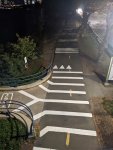
Is this striping on the Dudley Path at the Mass Ave bridge and at Charles Circle new? I don't remember it being there a few days ago.

It seems kind of odd that bikes on the path are supposed to yield to bikes entering in both locations, and Mass Ave that's the opposite of what people have typically done, and what you would expect.

PXL_20221019_224546125.jpg
 
Is this striping on the Dudley Path at the Mass Ave bridge and at Charles Circle new? I don't remember it being there a few days ago.

It seems kind of odd that bikes on the path are supposed to yield to bikes entering in both locations, and Mass Ave that's the opposite of what people have typically done, and what you would expect.

View attachment 29751
Those went in sometime two weeks ago. At Charles circle instead of yield “LOOK” is striped. Odd (and probably not MUTCD compliant?) but technically on shared facilities peds always have ROW over bikes. Its DCR so grading on that scale not horrible.
 
This got me thinking about the coned-off bike lanes on the Mass Ave Bridge. Are there any studies/updates to the prospect of making these permanent? And if so, what's the possibility of making a cut into the guardrail so cyclists exiting from the path can access Mass Ave northbound (and vice versa)?
 
Is this striping on the Dudley Path at the Mass Ave bridge and at Charles Circle new? I don't remember it being there a few days ago.

It seems kind of odd that bikes on the path are supposed to yield to bikes entering in both locations, and Mass Ave that's the opposite of what people have typically done, and what you would expect.

View attachment 29751
Saw this striping and other painted improvements at a few locations along the path last Wednesday. Wasn't there ten days before that, so yes, fairly new. I liked it, both here and further in to town. Yeah, we can quibble about the use of the "yield" arrows, but to be honest, most people probably think of those more as a sign for caution than anything else.
 
This got me thinking about the coned-off bike lanes on the Mass Ave Bridge. Are there any studies/updates to the prospect of making these permanent? And if so, what's the possibility of making a cut into the guardrail so cyclists exiting from the path can access Mass Ave northbound (and vice versa)?
I know that somebody (probably the city) is collecting data. I also overheard a rumor that some sort of announcement is forthcoming. As for a pavement cut, that would be awesome, but I doubt very much we'll see that any time soon.
Its not formal-formal yet, and the middle of the bridge is missing, but it was presented in the MassDOT highway report yesterday: the highlights are buffered bike lanes for the bulk of the bridge, with some pinching at the Boston end to accommodate turn and bus lanes. the buffered lanes look somewhat narrower than the coned ones which currently occupy a full traffic lane, though not at the message boards, to accommodate those bus lane(s?), but overall I have no objections to what's shown. Apparently we should expect implementation to start next month!

mabsi1.png
mabsi2.png
 

Back
Top