Crazy Highway Pitches

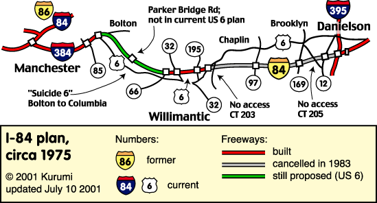
My Pitch: A combined dynamically-tolled road and high-speed rail alignment between Hartford and Providence on the alignment of the original I-84.
Road would be similar to MD-200, in that it would be purely e-tolled and otherwise just 2 lanes in each direction. Could even be HOT (and allow free carpool access to I-84's existing north-of-Hartford HOV lane.

The idea of tolls is both to limit induced demand and noise impact on neighbors, while at the same time paying for both the road and the rail construction. Should charge higher tolls for trucks to price in both wear and tear and again to limit impact on neighbors.

i84e-plan.gif


(road details at: https://www.kurumi.com/roads/ct/harttoprov.html)


And this for the rail:

Love that and the prospect of a Hartford - Providence - Boston high speed rail corridor.
 
Looks like Mass DoT heard you Newton - Traffic signal and safety improvements at interchange 127

Here is what I would suggest but it will stir up Newton Corner into a frenzy!
View attachment 33728

Something definitely needs to be done here. The problem is definitely traffic backing up onto the highway from the exit, but also that people from the next lane over dont get in at the back of the line and instead stop in their lane blocking people behind them and then try to squeeze into the exit traffic. Its a shit show.
 
Last edited:
Something definitely needs to be done here. The problem is definitely traffic backing up onto the highway from the exit, but also that people from the next lane over dont get in at the back of the line and instead stop in their lane blocking people behind them and then try to squeeze into the exit traffic. Its a shit show.
Queue jumping is ingrained Masshole behavior. It happens everywhere there is a lane backup. Designs need to not allow late entry into the queue.
 
My idea for a relocated Route 1 through Melrose Saugus, and Lynnfield. It would be a 6-lane expressway, fully grade separated with interchanges. The purpose of this would be to enable the conversion of the existing Route 1 to a smaller street and greenway with bike and pedestrian paths. This would enable development of housing along this revamped roadway and new greenway. I tried to keep the new expressway from cutting through the middle of residential neighborhoods, keeping it to the periphery, but with some acquisition of residential properties needed.

Here's the Google map. Zoom in as needed. The red line is the new expressway. On/off ramps at key cross streets are not shown.

Honestly, I'm not sure you need to relocate anything... the entire length of Route 1 is more or less fronted by auto-centric commercial, and light industrial, mostly with large expanses of parking to grab. If you're going to improve all of that, you can remove all the curb cuts anyway. Given the proximity to residential properties, it would probably make more sense to put the greenway on your proposed path and leave the road where it is.
 
Honestly, I'm not sure you need to relocate anything... the entire length of Route 1 is more or less fronted by auto-centric commercial, and light industrial, mostly with large expanses of parking to grab. If you're going to improve all of that, you can remove all the curb cuts anyway. Given the proximity to residential properties, it would probably make more sense to put the greenway on your proposed path and leave the road where it is.
Leaving Rte 1 as is but with a separate greenway/bikepath/trails added in a parallel corridor is an option. But I pretty much hate what Route 1 is. To me it's a train wreck. My proposal of a new expressway in a separate corridor would enable transforming the existing Route 1 into a full-fledged linear city of high density housing, ped paths, and bike paths to complement, and replace some of, the commercial development already there. I'd like to see included a light rail line in this transformed Rte 1, connecting with the Blue Line in Revere. A multi-modal high density corridor stretching from Revere to Lynnfield would be the result.
 
Last edited:
Here's the Google map. Zoom in as needed. The red line is the new expressway. On/off ramps at key cross streets are not shown.

The base map is out of date (Google needs to update some of their imagery), that path goes through a large new building not yet on the map, just south of the Kane's Donuts.
 
The base map is out of date (Google needs to update some of their imagery), that path goes through a large new building not yet on the map, just south of the Kane's Donuts.
I hate it when that happens, LOL. But seriously, thanks for the heads up, and I may tweak that route a bit.
 
I hate it when that happens, LOL. But seriously, thanks for the heads up, and I may tweak that route a bit.

There's a couple of new-build buildings right around there, none of which properly show up on the maps. There's probably some way to Crazy Pitch a highway through there, but it's not gonna be that easy.
 
My idea for a relocated Route 1 through Melrose Saugus, and Lynnfield. It would be a 6-lane expressway, fully grade separated with interchanges. The purpose of this would be to enable the conversion of the existing Route 1 to a smaller street and greenway with bike and pedestrian paths. This would enable development of housing along this revamped roadway and new greenway. I tried to keep the new expressway from cutting through the middle of residential neighborhoods, keeping it to the periphery, but with some acquisition of residential properties needed.

Here's the Google map. Zoom in as needed. The red line is the new expressway. On/off ramps at key cross streets are not shown.
In general Rt 1 is tough traffic wise anytime of day but the real issue is the cutting in and out of driveways at 40 mph. I think this leads to the start and stopping of traffic and it translates to the other lanes where thru traffic has to hope no one jumps into their lane to get around the stoppage ( no patience). I'm surprised there hasn't been an effort to reduce the highway to two lanes each way and attempt to paint carriageway lanes on each side for local traffic. Even if it started with striping, signage and plastic pole type of barriers for separation for the carriage lanes, it would help provide an area of transition. Eventually full build would be taking land on each side to have fully separated travel lanes by curbs and guard rails.

I'm sure the businesses along there would be against any barrier that would prevent a driver cutting across three lanes of traffic at 50 mph in a last minute decision to get McDonalds or gas. I believe that is what also scares everyone along that stretch of highway. I've seen it happen a couple of times. (Maybe even myself once?) The barriers would be helpful in preventing this act as well. For now, your head needs to be on a swivel for that stretch of highway.
 
Last edited:
In general Rt 1 is tough traffic wise anytime of day but the real issue is the cutting in and out of driveways at 40 mph. I think this leads to the start and stopping of traffic and it translates to the other lanes where thru traffic has to hope no one jumps into their lane to get around the stoppage ( no patience). I'm surprised there hasn't been an effort to reduce the highway to two lanes each way and attempt to paint carriageway lanes on each side for local traffic. Even if it started with striping, signage and plastic pole type of barriers for separation for the carriage lanes, it would help provide an area of transition. Eventually full build would be taking land on each side to have full travel separated by curbs and guard rails.

I'm sure the businesses along there would be against any barrier that would prevent a driver cutting across three lanes of traffic at 50 mph in a last minute decision to get McDonalds or gas. I believe that is what also scares everyone along that stretch of highway. I've seen it happen a couple of times. (Maybe even myself once?) The barriers would be helpful in preventing this act as well. For now, your head needs to be on a swivel for that stretch of highway.
The history of this road is typical of poor Massachusetts planning. Back in the late 1940s, frontage roads should have been set up along both sides of this route, and new businesses set back on the frontage roads. Instead, the cities and the State just allowed burger joints, shopping centers and various other crap to be built right up against the highway with curb cuts and driveways everywhere. Obviously a parallel expressway like I proposed above will never be built, but I like your concept. I would want two thru lanes in each direction, plus one-way collector/distributor roads separated from the through lanes by greenway strips wide enough for bike and ped trails. This would require some taking of parking lot areas along both sides of the highway.
 
Last edited:
The history of this road is typical of poor Massachusetts planning. Back in the late 1940s, frontage roads should have been set up along both sides if this route, and new businesses set back on the frontage roads. Instead, the cities and the State just allowed burger joints, shopping centers and various other crap to be built right up against the highway with curb cuts and driveways everywhere. Obviously a parallel expressway like I proposed above will never be built, but I like your concept. I would want two thru lanes in each direction, plus one-way collector/distributor roads separated from the through lanes by greenway strips wide enough for bike and ped trails. This would require some taking of parking lot areas along both sides of the highway.

I think some of that history was the assumption that a parallel expressway would be built - namely I-95 through the Lynn Fells. When it wasn't, US-1 has continued to carry traffic that is out-of-step with its design.
 
I think some of that history was the assumption that a parallel expressway would be built - namely I-95 through the Lynn Fells. When it wasn't, US-1 has continued to carry traffic that is out-of-step with its design.
The Master Highway Plan for the Boston Metropolitan Area, 1948, laid out the framework for the system of future expressways inside Rte 128. It showed the existing Rte 1 through Saugus as the one and only highway to the northeast, feeding off of the (then) proposed NE Expressway. It wasn't until the late 1950s, after 90% Federal interstate highway funding happened, that the State decided to have a separate I-95 through Lynn Fells. This was probably deemed necessary because by then Rte 1 had been ruined by commercial development right up on the highway with curb cuts and driveway entrances.
The need for a separate I-95 expressway would have been avoided if, in the late 1940s before much development along Rte 1 had happened, the State had built frontage roads along Rte 1, thus making it a limited access expressway.
California had success doing this type of upgrade to highways in the 1950s, gradually upgrading a highway into a full freeway by building frontage roads alongside. I'm surprised the Mass highway czar at the time, William Callahan, didn't follow suit with Rte 1.
I think there is a critical difference between Route 1 in MA and a similar California highway of the 1950's. Route 1 is very old, dating back to the Newburyport Turnpike created in the early 1800's. By the 1950s there was already substantial development all along the road. Yes there is even more today, but it was certainly not greenfield in the 1950s. The cost of eminent domain land taking for frontage roads would have torpedoed any such effort, even if the local business interests didn't do it politically.
 
This is not actually crazy, but I don’t think we need a “reasonable highway pitch” thread.

Extend the controlled access portion of Rte 44 so that it goes all the way to 495. As it is, you cram highway levels of traffic into a stretch of road that always seems congested, with long lines at every light.

I’m sure there’s some parochial local politics reason it doesn’t go that far, but it really looks like it could.
 
The history of this road is typical of poor Massachusetts planning. Back in the late 1940s, frontage roads should have been set up along both sides of this route, and new businesses set back on the frontage roads. Instead, the cities and the State just allowed burger joints, shopping centers and various other crap to be built right up against the highway with curb cuts and driveways everywhere. Obviously a parallel expressway like I proposed above will never be built, but I like your concept. I would want two thru lanes in each direction, plus one-way collector/distributor roads separated from the through lanes by greenway strips wide enough for bike and ped trails. This would require some taking of parking lot areas along both sides of the highway.

Rt 146 in Millbury comes to mind. The vast majority of the route is at freeway standards now, but then you go through Millbury and peoples driveways are right off the highway and it has a 4 way intersection.

I saw recently that the other last 4 way in Rhode Island is finally being replaced with a fly-over, but for some reason theres still nothing for Millbury, even though its basically the exact same situation as Rhode Island.

I dont see there ever being a solution for the many driveways and businesses unless they just get bought by the state and demolished, but the 4 way could at least be fixed pretty straight forwardly.
What I would do is build a bypass expressway, shown as the red line on this google map. It would be 4.3 miles long and expensive, as well as controversial I'm sure.

Note: edited to make the map link shareable.
 
Last edited:
Riffing on the discussion in the thread on the 20-23 Cummings project: How could I-93 north of the Charles to 128 be re-envisioned to make it more sensible? Could exits be dropped?
 

Back
Top