
You are using an out of date browser. It may not display this or other websites correctly.
You should upgrade or use an alternative browser.
You should upgrade or use an alternative browser.
Cassidy Point
- Thread starter Redfern
- Start date
Island Frye
New member
- Joined
- Sep 11, 2025
- Messages
- 61
- Reaction score
- 135
Interesting...

lunardinosaur
New member
- Joined
- Oct 10, 2022
- Messages
- 98
- Reaction score
- 301
How mysterious...
Industrial capacity retained just at different site owned by Sprague and working waterfront aspect retained. Just different marine use. ~CHonestly, I hope you guys aren't building housing down there. The industrial capacity is too important.
Dr. StrangeHat
Active Member
- Joined
- Sep 13, 2012
- Messages
- 951
- Reaction score
- 1,264
Oooooo, interesting....
If we're taking bets, I'm thinking mixed-use development including residential, retail, a marina, a water-taxi service terminal, and a new soccer stadium.
If we're taking bets, I'm thinking mixed-use development including residential, retail, a marina, a water-taxi service terminal, and a new soccer stadium.
So according to the tax maps, everything south/west of Commercial Street is zoned Waterfront Port Development, which explicitly prohibits residential, hotels, and restaurants. And almost all of Cassidy Point is owned by the Sprague Corp. or Cianbro.
BUT there's an interesting and quite large empty lot just across the intersection of Cassidy Point and West Commercial, with frontage on Danforth Street, that's zoned B-5 – which is designed for "a mixture of uses, including marine, industrial, commercial, and a broad range of residential options, is encouraged. The B- 5 zone is characterized by larger underdeveloped lots with great potential for dense, clustered, urban mixed-use development and reuse of existing land and buildings."
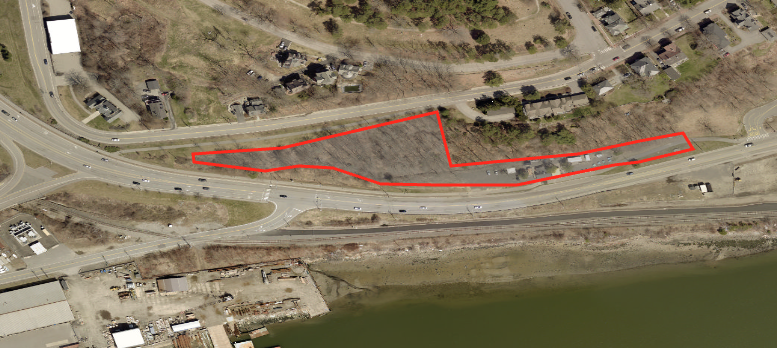
The owner is JB Brown, which recently hired Tuck O'Brien as a developer – Tuck used to work for the city and I know he's interested in building more housing. Could be a promising partnership...
A relatively tiny corner of this lot is currently occupied by the Clam Bar, which looks like it has a lease on the property, but there's plenty of room to the west for two or more larger buildings.
This is also another spot where it sure would be nice if the State of Maine and/or City of Portland could help by ceding some of its unused highway right-of-way on Commercial Street to help make the lot more develop-able. For some reason, the ROW widens right at the Cassidy Point intersection, and takes a big bite out of this parcel.
BUT there's an interesting and quite large empty lot just across the intersection of Cassidy Point and West Commercial, with frontage on Danforth Street, that's zoned B-5 – which is designed for "a mixture of uses, including marine, industrial, commercial, and a broad range of residential options, is encouraged. The B- 5 zone is characterized by larger underdeveloped lots with great potential for dense, clustered, urban mixed-use development and reuse of existing land and buildings."
The owner is JB Brown, which recently hired Tuck O'Brien as a developer – Tuck used to work for the city and I know he's interested in building more housing. Could be a promising partnership...
A relatively tiny corner of this lot is currently occupied by the Clam Bar, which looks like it has a lease on the property, but there's plenty of room to the west for two or more larger buildings.
This is also another spot where it sure would be nice if the State of Maine and/or City of Portland could help by ceding some of its unused highway right-of-way on Commercial Street to help make the lot more develop-able. For some reason, the ROW widens right at the Cassidy Point intersection, and takes a big bite out of this parcel.

Portlander
Active Member
- Joined
- Feb 12, 2026
- Messages
- 323
- Reaction score
- 849
Industrial capacity retained just at different site owned by Sprague and working waterfront aspect retained. Just different marine use. ~C
Maybe Cianbro has decided that they no longer have a use for their facility on the Portland Waterfront? This would be a perfect location for a "different marine use" especially if Sprague actually owns the land and has leased it to Cianbro for all these years. Though I could not imagine a residential use with trucks, ships, trains and aircraft being active around the clock. cneal, I think the land area you highlighted is known as Cassidy Hill.
Last edited:

MarkHB
Active Member
- Joined
- Feb 13, 2026
- Messages
- 180
- Reaction score
- 185
One thing that has been on the MaineDOT and CSX wishlist for years has been the removal of the overpass on the upper portion of Cassidy Point Drive, because it blocks double-stacked rail traffic. The downside is that removing it - and hence the upper connection to West Commercial - makes it much harder for truck traffic to get to the point from the Veterans Bridge.
I'm guessing that the ROW widening is due to some combination of truck turning space and the former rail line on the north side of Commercial.
While we're in the area... Those of us who remember the Gateway Circle days... Did the little connector from the circle to Commercial St. have a name?
I'm guessing that the ROW widening is due to some combination of truck turning space and the former rail line on the north side of Commercial.
While we're in the area... Those of us who remember the Gateway Circle days... Did the little connector from the circle to Commercial St. have a name?
With the coal pile going away, one of the warehouses dismantled, is Sprague moving its ops across the water to SOPO.
IMT expands to Cassidy as a result? Long shot-Scotia Prince is putting in a bid for 2027 to Nova Scotia, they are currently looking at Portsmouth, Cianbro uses area to build and expand ops?
IMT expands to Cassidy as a result? Long shot-Scotia Prince is putting in a bid for 2027 to Nova Scotia, they are currently looking at Portsmouth, Cianbro uses area to build and expand ops?
MarkHB
Active Member
- Joined
- Feb 13, 2026
- Messages
- 180
- Reaction score
- 185
Scotia Prince? Do you mean The Cat? Or is someone trying to take over the route with a regular ferry vessel as opposed to a catamaran?With the coal pile going away, one of the warehouses dismantled, is Sprague moving its ops across the water to SOPO.
IMT expands to Cassidy as a result? Long shot-Scotia Prince is putting in a bid for 2027 to Nova Scotia, they are currently looking at Portsmouth, Cianbro uses area to build and expand ops?
(The original Scotia Prince, unable to be upgraded to SOLAS standards, went to the breakers and became razor blades.)
Scotia Prince? Do you mean The Cat? Or is someone trying to take over the route with a regular ferry vessel as opposed to a catamaran?
(The original Scotia Prince, unable to be upgraded to SOLAS standards, went to the breakers and became razor blades.)
Scotia Prince Cruises – Halifax – Boston Ferry Service
 sailscotiaprince.com
Portlander
Active Member
- Joined
- Feb 12, 2026
- Messages
- 323
- Reaction score
- 849
The Nova Scotia port is still to be determined? It would have to be Yarmouth again because their site claims a 20 hour crossing and Halifax is 24 hours @ 16 knots which would provide zero turnaround time. Portland to Halifax would have been a winner back in the day!

Cosakita18
Senior Member
- Joined
- Jun 14, 2016
- Messages
- 1,172
- Reaction score
- 2,373
The Hearts of Pine are planning to move to Cassidy Point!!

 www.pressherald.com
Portland Hearts of Pine plan to build stadium, eye 2029 opening
The Maine pro soccer team's new goal is to move from Fitzpatrick Stadium to a new home at Cassidy Point, which will seat up to 11,000 people and cost around $50 million.
www.pressherald.com

cranewatch
New member
- Joined
- Jan 31, 2026
- Messages
- 33
- Reaction score
- 83
Fantastic news! I just added the project to https://cranewatch.biz/. 
Island Frye
New member
- Joined
- Sep 11, 2025
- Messages
- 61
- Reaction score
- 135