Alewife T Station, Garage, Bus, & Trails

Arlington

Moderator
Staff member
Joined
Dec 10, 2011
Messages
5,599
Reaction score
2,700
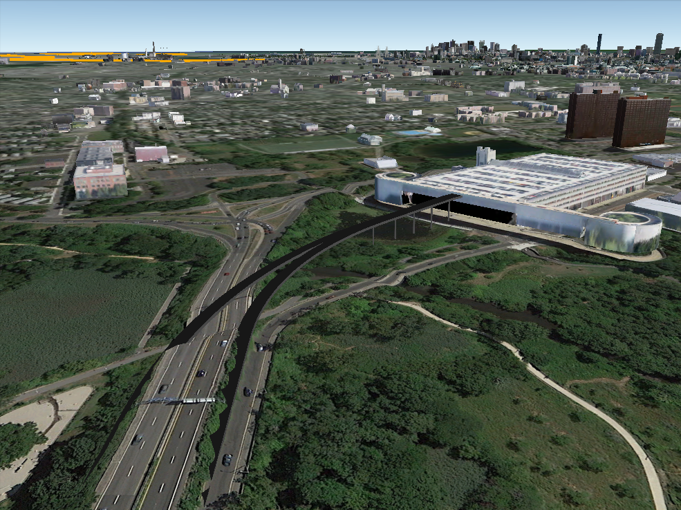
The Alewife Garage is kind of a big deal:
1) Bus hub (7 bus lines)
2) Bike hub ~800 bike spots, many (most?) card-access bike parking spots
3) Bike trail hub (at the convergence of the Minuteman, Fitchburg Cutoff (Belmont), and Alewife Linear Park-Community Path)
3) Parking Hub (2,733 spaces with >95% occupancy (it fills up))
4) Red Line Terminus

Here's what's wrong:
1) Car Parking levels 6 & 7 never got built! Why? Really? Why? The elevator shaft was built to accommodate 2 more floors of parking, and the column-stumps for higher levels jut out all over level 5, but that's it. If you say "the foundation's can't handle it" (like they were warrantied to, presumably) I'd say that foundation-underpinning in wetlands is much advanced since 1988.

2) Incomplete "inbound" road access. Route 2 gets "necked down" right where Gov. Sargent stopped it...a few hundred feet short of where Gov. Dukakis put his Alewife access road. This stinks. There should be a full bus-bike-car "direct to T" lane and there isn't.

3) Crappy outbound access. Rt 2 & 16 & Station Exit intersection is a disaster. Why is there not a dedicated bus-and-exit road that'd use some of all the extra space under the new (c. 2009) Rt 2 overpass? There needs to be 1 new "outbound" lane on Rt 2 to Lake St in Arlington and dedicated to station exits by bus and car.

4) Lousy bike-ped access "perpendicular" to the Minuteman (the daunting "hump" to get to Fresh Pond Mall and the overgrown side paths on Rt 16)
 
(2) and (3) need to be dealt with before (1).

As I said in the other thread, you want your major park-n-ride garages to be near major highway capacity. Otherwise you end up with...well.. Alewife.
 
Two more issues for pedestrians (amongst many others);

1.) It's a mugging danger zone in many places, especially at night when traffic is low. Lighting is ok but doesn't help you that much when you are isolated from most other traffic.

2.) I've seen giant chunks of concrete on the ground and holes in the ceiling where the Linear Path goes under the Fresh Pond Parkway. Does not inspire much confidence walking beneath there.

Certainly an area that could use tons of improvement.
 
(2) and (3) need to be dealt with before (1).
As I said in the other thread, you want your major park-n-ride garages to be near major highway capacity. Otherwise you end up with...well.. Alewife.
Alewife is *very* near the 4-lane splendor of Route 2. The maddening part is just the last several hundred feet.

I'd also say that as bad as Alewife is, more parking would help it divert more cars off Mass Ave and Concord Ave. Too many commutes from the 'burbs to Central, Porter and Harvard--that could be easily diverted into a parking space and onto the T--are clogging up the inner roads because Alewife turned them away due to its lack of parking.

Ideally, in combination with adding parking at Alewife, we'd get improved bus priority on Mass Ave for the 77 and 96 (take either some parking on the "rush" side of the street, or taking a lane) and the 72/75 74/78 on Concord Ave.
 
Totally agree. But, in effect, it is almost like it is far away. Alewife is practically a case study demonstrating how putting the parking garage just beyond the reach of the highway capacity causes big problems. It was bad planning in cutting back the Red Line extension, and the fucked up politics of the 1970s at work.
 
Totally agree. But, in effect, it is almost like it is far away. Alewife is practically a case study demonstrating how putting the parking garage just beyond the reach of the highway capacity causes big problems. It was bad planning in cutting back the Red Line extension, and the fucked up politics of the 1970s at work.

Well, the reason that the garage was beyond the reach of highway capacity was that the Inner Belt that was supposed to meet Route 2 never got built, resulting in the bottleneck right before the station. As you probably know, they built the station to the specs of planning documents from before the cancellation of the freeway, even though the Red Line extension followed the cancellation of the Inner Belt by many years.

Not to say we miss the Inner Belt, but this was one consequence. Also, if the intersection of 16 and 2 wasn't in wetland hell, we'd have a far smoother connection between everything there.

Extending the Red Line to Arlington to pick up some of the drivers might have helped, although I get the sense that a lot of people ended up walking or biking to the T from there. Extending the Red Line down Route 2 to 128 would probably do quite a bit more from an Alewife-relief standpoint, since it would spread the load.

As a sometimes commuter to Alewife by car, I actually find that the source of most of the inbound delay is @$$*&$s shooting across from the left lane to the Alewife ramp at the last possible second, and people merging across from Lake St. to get to 16EB. For the former, there needs to be a designated and separated "exit only" lane beginning at the latest in front of VOX. For the latter, I wonder if it would be possible to close that ramp and send the traffic through the office park and out onto the access road. They could then go past the station out to Fresh Pond Parkway or make the right off of the egress road, depending on which direction they were going. A collector-distributor road might be another option.

Really, though, you could do so much there just by solid-lining all 3 lanes, with one apiece for the access road and WB and EB 16, starting in front of VOX. The behavioral impact of that would make a big difference on its own.
 
Really, though, you could do so much there just by solid-lining all 3 lanes, with one apiece for the access road and WB and EB 16, starting in front of VOX. The behavioral impact of that would make a big difference on its own.

Definitely worth trying! To whom do we write?

Starting back where it is 4 lanes, they need signs over each lane
Code:
      Cambridge             T          Lake St
Mass Ave    Fresh Pond   Station    Arlington
Medford      Boston      Alewife      Belmont
   |            |           |          ONLY
   V            V           V             V

Starting back at the Rt 60 Overpass
http://goo.gl/maps/a0pWA

And on this gantry, the could start by snuggling the "Alewife" sign over to the right and giving it a "down arrow" pointing to only the rightmost lane
http://goo.gl/maps/LwI4v

But even better would be

Code:
      Cambridge             T          Lake St
Mass Ave    Fresh Pond   Station     Arlington
Medford      Boston      Alewife      Belmont
   |            |          ONLY         EXIT
   V            V           V             V
 
It would be ugly, but honestly, I think they should widen RT 2 from Lake St to Lanes and Games, and then build a viaduct from there STRAIGHT INTO two new levels of garage.

This would give people coming in on RT 2 direct access to the red line and garage, avoiding pedestrians, cyclists, the insane intersections, everything. It would also have the added benefit of loading the garage from the top down for suburban commuters, making more efficient use of a tall garage.

Then the lower levels and street access would be reserved for those coming from everywhere else. Traffic would be a gazillion times more bearable, and it would be safer for everyone on the ground as well with a few thousand cars removed entirely. Since the new viaduct would go into the upper levels, it would also be so high that it wouldn't be the typical depressing highway overpass. 30' of concrete some 80' over peoples heads would barely be noticeable.
 
^Somewhat similar to Quincy Adams?

Doesn't solve the issue of getting people out of the garage though?
 
^Somewhat similar to Quincy Adams?

Doesn't solve the issue of getting people out of the garage though?

Yeah, the distance is just greater. The ramp would have access to the garage from RT2 inbound, and from the garage to RT2 outbound.

Super quick rendering for the idea:
15359142467_33c61dc85c_o.png


As mitigation for building a ramp through the middle of the wetlands there, the current alewife access road could probably be closed. It would push more non-garage bound traffic through the clusterfuck where 2, 3 and 16 all meet, but it may be an acceptable trade off. The minuteman could certainly use more space through there, anyway.
 
The problem with that idea is that CambridgePark drive is a large and growing concern. Now, that would be all right turns, so maybe not a disaster...
 
I like trying the signs and some striping paint first, personally. These also have the virtue of fitting the civil-engineering / capacity planning rule:
Organization before Electronics before Concrete

Just getting people to line up orderly could be a cheap "organization"

Electronics, in this case, would be smarter signals at the intersections and a better system for finding empty spots in the Garage (the kind that "point" to empty spots)

Concrete, is, well, flyovers and flyunders.

One thing to be aware of is that the tail tracks from the Alewife subway tunnel turn and run under the access road (they point the way to any extension to Arlington Center) They run nearly to the Thorndike Field Parking lot, IIRC.

How about a single reversible flyover that ties into the "median" of Rt 2? (exit left for the flyover in the AM, flyover dumps people in the left lane of outbound Rt 2 in the PM). Its also the AM peak that is "sharper" and having both "entrances" running in the AM would be good (and in the evenings, you'd have 1 entrance at grade level, and the flyover as the exit)
 
The biggest problem with Rt 2 inbound by Alewife at the 16 intersection is that the people trying to squeeze into the second eastbound lane (towards Medford) block the westbound lane (towards Fresh Pond). If you either; solid striped the lanes to stop people from merging eastbound at the last second and block up the road OR somehow squeeze a second passing lane for westbound drivers you could do wonders for clearing up that part of the mess.
 
That rotary could get a lot cleaner if they just eliminated the second set of staggered lights for 2WB traffic. This has no purpose in life. Do some curve reshaping on the 16W-to-2W ramp and lose the sidewalk up and over the bridge and you can have a controlled merge here without needing to widen the bridge.

Total free movements 16W-to-2W at bare minimum. And if there's an abrupt lane drop on the 16E-to-2W side between light #1 and superfluous light #2 the signal can get taken down from that side too in lieu of a simple 1 + 1 = 2 lane free merge. Yes, the lane drop might get a little hairy days there's a disablement stretching back on 16E...but I'd take those odds for 4 much better PM rushes per week of much better traffic flow outta there for 1 hell commute per week where you barely notice the parkway is backed up a few hundred feet further past the Mall...because it's always backed up.


That doesn't solve the problems. You're never going to solve the problems if the wetlands don't allow a direct station-to-2W onramp. And they probably don't allow, otherwise they'd have built it long ago. But it's a sane amount of cleanup. Superfluous lights #2 are always out of sync with lights #1. Cars going 16W-to-16W and 2E-to-16E get blocked by cars going 16E-to-2W overspilling at superfluous light #2, shooting those queues to hell back into Arlington and back out to Mass Ave. At least this makes everything coming from Mass Ave. flow nice and free with queues chopped to the point where they'll never back up. And does enough cruft cleanup that the other backed-up directions don't have to stumble and stagger and trip all over each other. 'Crisper' might actually go a long way.


As for the garage, and fixes therein...can't isolate it to the garage. The whole station is falling apart. 3 decades of water damage at track level, half the lighting doesn't work, glass atrium leaks, pavement/sidewalks/concourses crumbling to dust, entrance doors that are busted. You can't really compartmentalize too finely where you start on state-of-repair. The whole damn concrete hulk of a complex needs a substantial midlife renovation in which attacking key structural parts first means attacking some key structural part in EVERY facet of the station, massive garage included. If the foundation's too weak to open up levels 6 & 7...well, that's kind of terrifying for Levels 1 & 2 as well. Levels 1 & 2 of the garage, Levels 1 & 2 of the station, Levels 1 & 1 of the busway and kiss-and-ride. Can't be real choosy about where to start when the swamp's not as strong at holding the whole mass of it up as well as 1981's best civil engineers hoped it would after 33 years.
 
To reduce congestion, I'm thinking an underpass such as this would help:

15365238009_0a01fa7559_c.jpg
 
To reduce congestion, I'm thinking an underpass such as this would help:

15365238009_0a01fa7559_c.jpg

Water table wouldn't permit going subterranean with anything. "Swampy" doesn't even begin to describe the soil there.

That same configuration would work, however, if you traded equal parts cut on the onramp underpass with rise on the rotary to keep the cut/retaining walls/drainage only 6 feet below the current level of the rotary.

Can't totally drop it down to the level of the existing offramp because the pond's drainage filters passively through the soil under the rotary, while with the offramp it passes actively through that stream under the bridge. That's why the rotary was landfilled up to higher ground when first built...so it stays above the porous water table that connects the moats on the Arlington and Cambridge sides.

So to stay above the water table you'd just keep the gradual uphill slope going where the various rotary legs off 16 pass above those ramps on your rendering, instead of the rotary leveling out at the lights (and even very slightly dipping in the middle) like it does today. That creates enough extra rise to carve out a very shallow half-cut underneath for the onramp. Make the space by splitting the difference.


It would be expensive and a royal pain in the ass to construct because of the disruption during construction. But it is potentially viable if the wetlands allow for no other direct alignment. And they probably don't.
 
Yeah, I was thinking that the intersection would need to be raised on fill several feet to keep the underpass from dipping below the water table. I think with the intersection raise, the underpass might be feasible.

I would just as soon see flyovers built as in Davem's rendering, but the Boston area is hyper-sensitive to anything elevated. I can picture all the Nimbys in the area screaming bloody murder about any kind of flyover. Thus, the underpass proposal.
 
Would a true rotary + dedicated lanes on the exterior of the triangle improve things at all by taking out he light cycles?
 
Would a true rotary + dedicated lanes on the exterior of the triangle improve things at all by taking out he light cycles?
I love those, especially where (as here) you can accommodate the pedestrians elsewhere, but I think it would take more footprint than is available here.
 
CTPS did a report five years ago that recommended a package of cheap fixes to improve car and bus travel through the area, but it has been sitting on a shelf ever since. If MassDOT/DCR/MBTA can't find $200k-$400k between them to even do this then I really doubt they'll be able to do any of the more intensive rebuilds.

• Add a third westbound lane (Option 4) for a short distance between the Alewife Station Access Road approach (jug-handle) and the Minuteman Bike Path overpass (Figure 6).
This would be effective in reducing delays and queues at this intersection. The additional lane capacity frees up traffic signal green time for reallocation to other approaches, including the MBTA Access Road, resulting in shorter queues and delays on all approaches. Right-of-way is available for the portion of the third lane within the intersection. Right-of-way also appears to be available for the lane segment between the intersection and the Minuteman Bike Path overpass; however, the additional roadway width would have to be secured from an existing (possibly unused) sidewalk. The availability of right-of-way between the point where the Route 16 north approach meets Route 2 westbound and the overpass needs to be investigated further, including the need for a pedestrian corridor north of Route 2. Extending the third lane to Lake Street is not required in the short term but should be considered in the longer term.

• Reconstruct the Route 2 eastbound left-turn lane to Route 16 north into a double left-turn lane (Option 2 and also part of Option 4). This would further benefit this intersection, as it would help reduce eastbound queuing on Route 2.

• Reconstruct the Alewife Station Access Road (jug-handle) into two lanes for as far back as possible. This would allow for bus and vehicle storage and for priority bus lane/traffic signal priority for the buses.

• Following all above reconstruction, the traffic signal design would have to be reconsidered, including new equipment for demand-responsive operation and
detectors/sensors for bus priority.

Excluding design and right-of-way, the estimated cost of the recommended improvements to the Route 2/Route 16 intersection ranges between $200,00 and $400,000

See http://www.ctps.org/Drupal/data/pdf/studies/highway/alewife/Alewife_Traffic_and_Bus_Operations.pdf , they went through quite a few alternatives and have Synchro and Vissim modeling results.
 

Back
Top