Re: North-South Rail Link
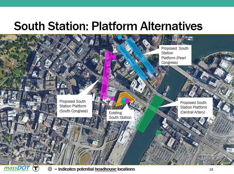
Thoughtful debunking/skeptical analysis here, F-Line [and I would've expected no less]. I just want to point out, though, on the rising sea level consideration, which is what I immediately intuited as the possible key criteria: since the original Downtown shoreline pretty accurately corresponds to the Congress St. corridor, the fact is that the west side of Congress St. is the original geological strata, whereas the east side is landfill. So leaving aside the portals, what about the question of the porosity/permeability of the landfill strata vs. the original Shawmut peninsula composition? Apparently you're saying that's a non-starter?
There is NO difference in flood protection between alignments. Portals are exactly the same places they were before because there's only discrete places they can possibly slot...like for example the NEC portal which has to be between Shawmut and Harrison centered on the Washington block because west is the Orange Line tunnel and east is the giant mass of switches for surface Cove Interlocking. Portals will have to have flood doors and active pumping, but down below has no potential for water intrusions.
Thoughtful debunking/skeptical analysis here, F-Line [and I would've expected no less]. I just want to point out, though, on the rising sea level consideration, which is what I immediately intuited as the possible key criteria: since the original Downtown shoreline pretty accurately corresponds to the Congress St. corridor, the fact is that the west side of Congress St. is the original geological strata, whereas the east side is landfill. So leaving aside the portals, what about the question of the porosity/permeability of the landfill strata vs. the original Shawmut peninsula composition? Apparently you're saying that's a non-starter?