RandomWalk
Senior Member
- Joined
- Feb 2, 2014
- Messages
- 3,713
- Reaction score
- 6,502
Isn’t this site under the 4L/R approach or 22L/R departure at Logan?
Not quite directly under the approach, but still pretty restricted. Looks like 200 to 225 ft. max. across the site.Isn’t this site under the 4L/R approach or 22L/R departure at Logan?
I suspect the problem is American's just don't really know how to do urban design and developer's realize that doing urban design makes it harder to get through approval rather than doing the Office Towers in a Parkland setting.View attachment 49734
I'm looking at that picture and I'm thinking 128 Burlington. That picture above is another soul-murdering architectural homicide. Whatever happened to the idea of Boston as a CITY?
Look, I know it's the Reserve Channel and all, but 12.9 FREAKING ACRES and all they can do is 205 residential units?????? I get that LEGO is now being used by engineers and architects over at MIT, but does every new building in Boston have to look like it was built by my 1967 set????
View attachment 49735
That would look great in post-industrial neighborhoods such as Everett or the Kendall Sq area.This waterfront site should allow for 10 of these buildings!
shipping-container-skyscraper
View attachment 49766
I suspect the problem is American's just don't really know how to do urban design and developer's realize that doing urban design makes it harder to get through approval rather than doing the Office Towers in a Parkland setting.
Honestly this is also a market failure. If people who rented or leased buildings actually cared about the urban design and building architecture, the developers would do better, to attract tenants. Apparently not very many Americans care.Americans know how, but just like anything that costs money - -it's far easier and cheaper to make a Hershey bar than it is to make Toblerone.
American developers CHOOSE to build huge landscraping boxes with little or no detail to get the biggest profit for the least investment. It is what it is. And until the BPDA starts giving a shit and lays down some conditions, it will remain as such.
Honestly this is also a market failure. If people who rented or leased buildings actually cared about the urban design and building architecture, the developers would do better, to attract tenants. Apparently not very many Americans care.
The only developers who care are ones who are developer/owner/occupiers, in for the long haul, usually institutions type developments.
God help us if the BPDA suddenly decided that Brutalism is all the rage again -- central planning worked so well in our mega-urban renewal era.The developers and the tenants don't give a shit about the architecture - - and its not their job to. They only care about the cheapest cost and the greatest return. That's Capitalism - - it is what it is.
The responsibility is on the city government to be the protector of the overall urban life experience. The BPDA could be an effective agency or it could be a worthless paper tiger. Look what happened in Kenmore Square with Whoop - - and what it replaced. Boston's public voice is AWOL.
 ("The mayor says he likes the blue glass on that proposal". Six months later: "Why are all the new development proposals clad in blue glass?")
We already have the Boston Civic Design Commission that plays the design and aesthetics oversight role on many projects. We just don't like their decisions.Between existing regulatory processes and market conditions, I don't think we need any additional barriers to development for the aesthetic sensibilities of people who aren't party to these transactions.
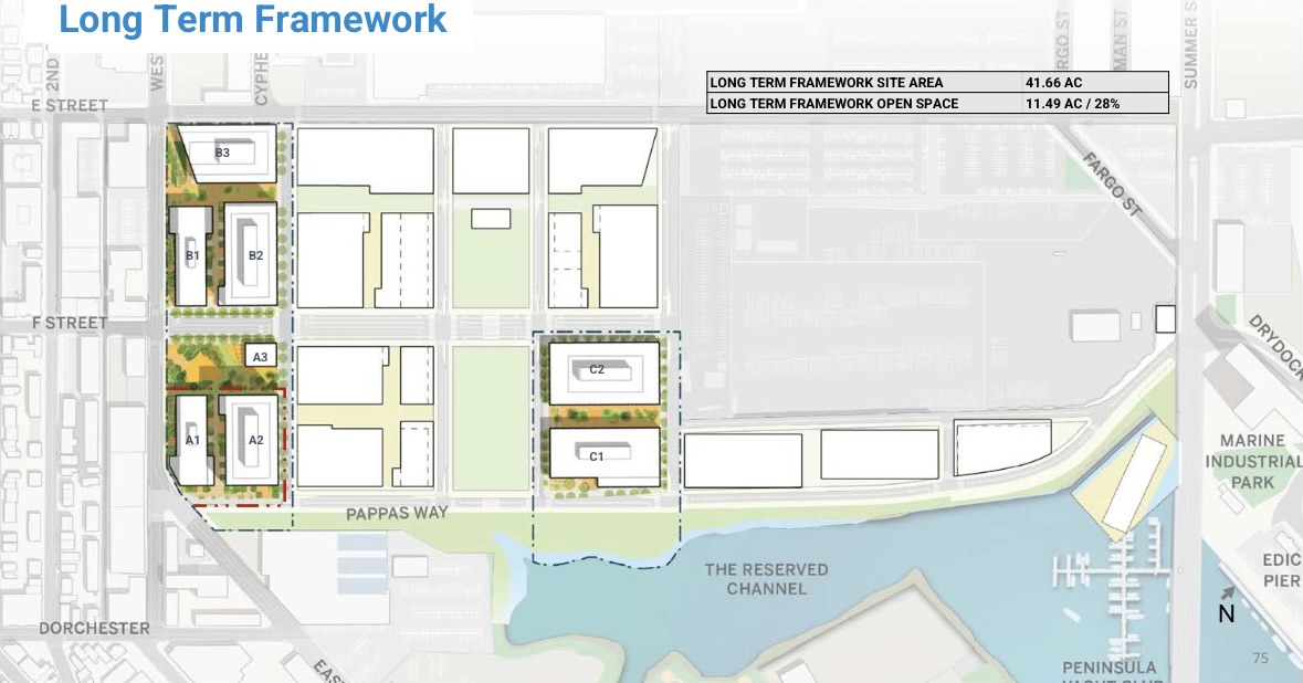


 bpda.app.box.com
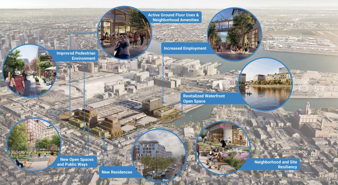
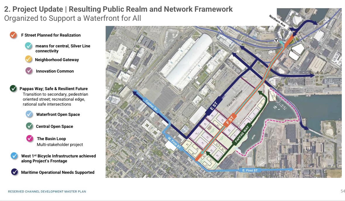
I love the forethought of F St. being a wider avenue for a Silver Line route. It will be the most direct way to get to the center of South Boston from Seaport and will hopefully have room for dedicated transit lanes at some point.
Yeah, I'm not clear on that either. In theory, an SL branch that goes to the City Point Bus Terminal is a good idea, and this branch could do that by turning left on to 1st St, but I'd rather a more direct route if that's the destination, such as turning on Summer Street. If the goal is to make the Silver Line more accessible to people in South Boston, it makes sense for it to hit a major transfer node for the local bus routes. Continuing along F street won't do that, and would instead essentially turn that SL branch into another Southie local route that gets stuck in traffic.I love the idea of the silver line going into southie this way but where does it go when it hits 1st st?
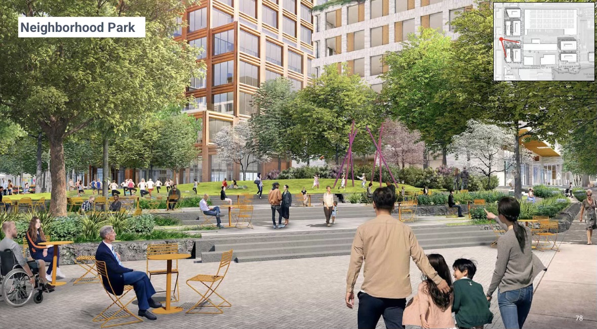
So with the lab market crash, have they realized this needs to be ~all resi + the grocery?
Hope so, the seaport has sooo much lab/office. The city needs so much housing, they should honestly go 100% housing here on a copy/paste extension of the southie street grid.So with the lab market crash, have they realized this needs to be ~all resi + the grocery?
Hope so, the seaport has sooo much lab/office. The city needs so much housing, they should honestly go 100% housing here on a copy/paste extension of the southie street grid.
This was kinda brought up last year in Crazy Transit pitches when we were discussing how to send the SL into Southie (although this was thinking more long-term after an LRT conversion alongside larger implications past South Station). @Riverside brought up the idea of sending branches via Pappas Way and Summer Street to hit multiple areas along the peninsula and get 10 minute walkshed for all of South Boston. The terminus of these branches would be Dorchester St at E Broadway and L St at E Broadway. @Teban54 added the potential idea of looping the branches into each other.I love the idea of the silver line going into southie this way but where does it go when it hits 1st st?
Assuming an LRT conversion of the Silver Line, I would probably look at some way to extend SL2 to City Point, or add a second branch that pops down along Summer St. Yhe original SL3 did poorly due to competition from the 7, but an LRT line would offer a 1SR to Back Bay and either Kenmore or Huntington, so it would probably command greater interest. I like @samsongam's thought process and visualization.
Heck, you could even have a second branch into Southie proper, with one going down Summer St (like @samsongam showed) and a second one reclaiming some space for a semi-dedicated ROW along Pappas Way, with about a quarter-mile of running on Dorchester St, into a transit plaza at the intersection with the Broadways:


That's quite an intriguing idea, even if not the most relevant.
But it got me thinking... How about a unidirectional loop that joins these two "branches" together?

Yeah, I'm not clear on that either. In theory, an SL branch that goes to the City Point Bus Terminal is a good idea, and this branch could do that by turning left on to 1st St, but I'd rather a more direct route if that's the destination, such as turning on Summer Street. If the goal is to make the Silver Line more accessible to people in South Boston, it makes sense for it to hit a major transfer node for the local bus routes. Continuing along F street won't do that, and would instead essentially turn that SL branch into another Southie local route that gets stuck in traffic.