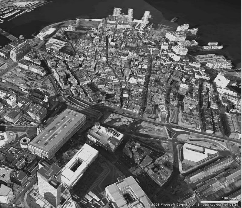
A New City Hall? Maybe

Boston, blobbed out

I also wanted to see what had disappeared.

Again, the photo is more of the North End than West End.

One question I have is, how come the area around the Union Oyster House was spared? Everything else around it was torn down. Historic preservation?

I couldnt' figure out what was torn down in the Canal Street / Friend Street area.

I don't have the exact boundaries of what was torn down and what remains. A trip to the North End is needed!

wipedout.jpg
 
bowesst said:
There is nothing wrong with Brutalist architecture as long as it is built where it belongs, or at the very least is designed with its surroundings in mind. Government Center is neither.

I vote for tearing it down and replacing the whole plaza with human scale buildings and street patterns. They should reconnect Hanover Street with Cambridge Street and try to blend the North End, Quincy Market, and Govt. Center together as much as they can. Maybe they get get some ideas from this.

I would have chained myself to the old Scollay Sq. Now that it is built, though, City Hall is too remarkable a building to be torn down. People simply need to learn to love it. For that, some TLC from a starchitecht would help, along with a re-invigorated Congress street and a cut-down, built up City Hall plaza,

How exactly to do all that, I don't know. Maybe I'd be a starchitect if I did...

justin
 
Re: Photo, updated (1)

IMAngry said:
If you look closely at the photo, you can see the North / South rail link, I think. It's a shame that went away!
Not quite. It's the Atlantic Ave. el, which did link North and South Stations, but did not connect to either commuter rail system, which is what's usually meant by a NSRL today. The el was perhaps a useful rapid transit link (though probably more so back then when the harbor was alive), but it was an eyesore comparable, if smaller, than the Central Artery.

justin
 
Merrimack and Portland streets both exist today, in the same locations as 100 years ago, so I don't understand your question about them.

The only large-scale demolition in the Bulfinch Triangle was caused by the Central Artery. The area between Canal and Merrimack streets is mostly intact, though interspersed with small parking lots where individual buildings were torn down.

The Atlantic Avenue el stopped service in the late 1930s and was torn down for war scrap metal in the early 1940s.

Lincoln Wharf is now condominiums.

On Prince Street, was that a water tank, or a gas tank? I'll have to drop into the North End library and ask someone. It's now a park and playground.
 
Notice the beach on Atlantic Ave.
 
That tank couldn't be the tank from the infamous molasses flood, could it?
 
No. The molasses tank was on the waterfront. I think the site is the big empty area on the photo above the words "Atlantic Ave."
 
Here's a before and after using Live Local's new 3D Feature, which is pretty cool.


Then:
1923a.JPG


Now:
LL_07.jpg
 
honestly i have no idea what most of those pictures are of.

Especially the first one with the molasses vat. What is that? What direction is it facing? Downtown? That's UNpossible. Possibly North End.
 
bosdevelopment said:
honestly i have no idea what most of those pictures are of.

Especially the first one with the molasses vat. What is that? What direction is it facing? Downtown? That's UNpossible. Possibly North End.

You don't see Quincy Market in the lower right corner?
 
Thanks for info

Briv, I used LIVE for comparison, but I didn't know you could get a photo ... and I forgot they have 3D now! Thanks, it is amazing to compare the two.

Ron, my question was, which road have I highlighted in the old photo? I can't figure out if it is Portland or Merrimac. I counted from above, Canal, Friend, and the next would be Portland, but it curves in the photo, so I was confused.

I was honoring the molasses flood by making my white-out look like Marshmallow Fluff (c).
 
I still don't understand your question. These two streets are in the same place today that they were when the Bulfinch Triangle was first built. Merrimac Street was recently widened, but otherwise nothing has changed about it. It is not curved.

Perhaps this 1928 map will help.
 
Any opinions on the building of a central station underneath whatever is built there? A central station could link North and South Stations as well as the Blue, Green and Orange lines.
 
According to a comment in my blog, it is a gas tank. Natural gas??? Not sure if it is acurate.

I've seen this picture before. One of my favorite aspects is the gas tank (which at present is a playground) located adjacent to the Brinks garage.

Someone once mentioned to me that it was one of the first places in the country to house/use natural gas. From later pictures I've seen, I believe the gas tank was torn down within a decade after the photo was taken.

Regarding the size of the gas tank, it is incredible. The Brinks is 4 stories tall. The tank must be at least double that. The diameter looks to be nearly as big as the current playground area. Simply put, that must have been a huge structure.
 
mikem978 said:
Any opinions on the building of a central station underneath whatever is built there? A central station could link North and South Stations as well as the Blue, Green and Orange lines.

I'd say State Street at the Blue Line.
 

Back
Top