Biking in Boston

I'm the last one to shrug off bike infrastructure, but re the Grand Junction... Does anyone else think the section parallel to Vassar Street would be a boondoggle? Vassar has excellent separated bike lanes for most of its length. Crossing the BU Bridge—totally get it. And everything between Main St and Twin City Plaza would be a critical unmet need that gets bikes off both crowded Cardinal Medeiros and messy Fulkerson. The rest of it? Meh.

D8c5ZGD.png
 
I'm the last one to shrug off bike infrastructure, but re the Grand Junction... Does anyone else think the section parallel to Vassar Street would be a boondoggle? Vassar has excellent separated bike lanes for most of its length. Crossing the BU Bridge—totally get it. And everything between Main St and Twin City Plaza would be a critical unmet need that gets bikes off both crowded Cardinal Medeiros and messy Fulkerson. The rest of it? Meh.

It's a classic case of building the "low-hanging fruit" section that's easiest, cheapest, and least disruptive. Optimistically, I'd say that doing this makes it more likely that the more necessary sections get built sooner. In total, the entire path will be a good link from Allston to Somerville and any easy-to-build segment moves us in that direction.
 
I think that both facilities can play nicely together - the Vasser St track for those looking a more direct route such as commuters and the GJP for neighbors wanting a park experience complete with dogs, little kids and joggers.
 
^ ... they'll be no more redundant than are the parallel separated auto lanes on Vassar & Albany Streets...
 
The segment from Fort Washington Park, under the BU Bridge and then linking to the Esplanade and Comm Ave is my highest priority segment since it creates a lot of neighborhood and regional connections that are currently stressful or impossible. Linking Cambridge, Allston, and Brookline into the PDW path and pulling bicyclists off of the BU bridge mess would be huge.

The segment from the future Somerville Community Path down to Binney Street would be my next priority due to a general lack of low stress N/S routes there, but doing a true bicycle boulevard treatment on Sixth Street could push off a need for that segment of the Grand Junction Path.

You’re right, the bit in the middle isn’t that important for regional bike travel. The Vassar Street protected bike lanes could use some minor repair work, some modernization, and a redesigned intersection at Mass Ave. But really they're fine and provide a higher level of service for bicyclists than the Grand Junction path would. The multiuse path through MIT is still a good project and will be great for walking around the campus and tootling around by bike.

But if it costs ~ $700,000 to build the 700 feet from Broadway to Main, then ideally that would be the last segment that gets built.
 
The schedule got bumped last year after the snowfall; I know - the JP news still has the countdown clock listing September.


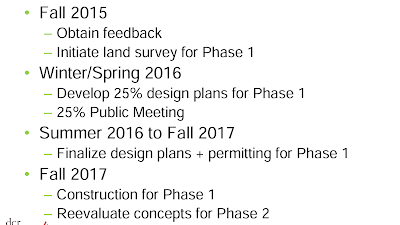
Even if it is Sept 30 or early next year, it is a different timeline than they presented in the october meeting, unless I am reading something wrong. Can anyone explain why the october meeting has phase 1 (the modern roundabouts and roadway between) starting construction in the fall of next year?

Screenshot_2015-10-19-16-50-05.png


full write up of october meeting - where I pulled the schedule from: http://arborwaymatters.blogspot.com/2015/10/improving-multi-modal-safety-access-to.html
 
BuilditDenser - I refer to the Casey Arborway (formerly Casey Overpass) currently under construction by the Highway Division of MassDOT (with the upper busway and station improvements by the MBTA). The post you reference is for the Arborway bike and ped improvements by DCR.
Clay has both projects on his blog and was asked about both in his WGBH appearance when he defended the MassDOT design for the Casey Arborway.


So is massdot just responsible to tearing it down, adding a headhouse/other t improvements, and rebuiliding it? Is the dcr is responsible for the cycle tacks and the traffic circles after massdot is done? When can we expect to use the protected bike lanes?
 
Two projects:
1. Casey Arborway currently under construction(with an MBTA Station improvements Sub-Project, including upper busway canopy) extends from the Current Shea Circle on the East to the Forest Hills Entrance to the Arnold Arboretum on the West side and south to Ukraine Way. See here: http://tinyurl.com/j5tblrt
The highway division demo'd the overpass, and is building the new roads, sidewalks, cycletracks, new landscaping, most of the upper busway (the canopy is being done by the MBTA) and the new headhouse. I understand that the project will have "full and functional use" (that isn't quite the correct legal term, but neither is substantial completion) by December 2016 with final landscaping done in spring of 2017. I would expect that most of the cycletracks would be completed by this fall, some possibly in the summer - the intersection of South St and the Casey Arborway (New Washington St) will be under construction until the project is nearly complete).
The MBTA will build the new canopy for the upper busway (the expanded deck and pavement was built by the highway division) and I understand, ADA improvements at Forest Hills Station. I have not seen any designs or documents showing the scope of the ADA station improvements, nor have I seen a schedule for this work. I am doubtful that the upper busway canopy will be in place by next winter. I really hope I am wrong.

2. DCR's Arborway Improvements: Currently this project is under design. The current design extends from Murray Circle to Kelley Circle at Jamaica Pond. See here for a map of what DCR is calling phase 1: http://tinyurl.com/hb5bawn

Phase 2 of DCR's Arborway Improvement project has been put on hold. That portion extended from the west end of the MassDOT's Casey Arborway project to Murray Circle. See here for a map: http://tinyurl.com/hvwwojz

I hope this helps...
 
As I understand it, a (very) significant portion of the funds for the Casey Arborway Project come from federal sources - the tail end of stimulus package Accelerated Bridge Fund monies that *must* be spent by September 30. As noted, I do think some aspects of the overall project like some station improvements are funded by other sources and potentially on a different (and unannounced) timeline. It has always been unclear to me exactly where that funding line is drawn, but I do believe the new head house and the ADA ramps at the NE corner of the station plaza are part of BHD's contract. I'm hopeful that we'll see evidence of the emergence of some features like new bike paths and sidewalks, "Shea Square" and the new mainline roadbed fairly soon. Full usage might be a different matter, but once the sewer work happening now is done there won't be much holding that back.
 
Some good discussion on that a couple pages back.

The quotes saying that they would reverse it so easily is news to me, last I heard the question was one of whether to make it the double-wide buffered bike lane between the traffic and parking lane, or to make it a protected lane between parking and the curb.

Ah. For some reason I thought this was a different section of Beacon (which, looking back a few pages, is clearly not the case).
 
the Brookline Advisory Committee postponed a vote to fund the Beacon St buffered bike lane last week. They sent an email explaining their decision to postpone the vote: "As you may have heard, the Advisory Committee postponed consideration of the Beacon Street bike lane. The Capital Subcommittee generally felt that it would be better to obtain more information and to talk further to Town staff before taking a vote. I expect that the Advisory Committee will vote on this project this month, but we haven’t set a date yet."

The protected lane (cycle track) option was previously scuttled by the fire chief who was concerned that even if emergency vehicles were to bypass traffic in the cycle track, they might get blocked by earlier responding emergency vehicles and or wouldn't be able to set up apparatus where it would do the most good.
 
"The protected lane (cycle track) option was previously scuttled by the fire chief who was concerned that even if emergency vehicles were to bypass traffic in the cycle track, they might get blocked by earlier responding emergency vehicles and or wouldn't be able to set up apparatus where it would do the most good."

Because apparently no other cities in the entire world that have cycle tracks also have fire trucks.
 
Yet more fun public hearings in Brookline:
The plans will apparently be available tomorrow.

Babcock Street Public Hearing
Babcock Street Pedestrian & Bicycle Improvement Plan
Wednesday, April 13, 2016
7 PM to 10 PM
Selectmen’s Hearing Room – Town Hall
333 Washington Street
The Transportation Board is seeking input on the various options put forth on altering the public right of way to accommodate all three transportation modes (pedestrians, cyclists, motor vehicles) on Babcock Street in advance of the planned roadway reconstruction in 2017. Plans are available for download on 4/6/2016 at www.brooklinema.gov/transportation and include potential traffic calming, cycle tracks, parking removal, partial one-way, and other options.
 
"The protected lane (cycle track) option was previously scuttled by the fire chief who was concerned that even if emergency vehicles were to bypass traffic in the cycle track, they might get blocked by earlier responding emergency vehicles and or wouldn't be able to set up apparatus where it would do the most good."

Because apparently no other cities in the entire world that have cycle tracks also have fire trucks.

Beacon is a major artery and access road for many types of emergency vehicles. Aside from that, I don't think this is a great project. Growing up in Brookline, even in the days when bike lanes didnt exist, the sidewalk on this stretch was perfectly fine if riding at night - get your panties in a bunch about bikes on sidewalks, but as a cyclist and a driver this particular stretch does not have a need to lose a lane for a cycle track.

A better option would be to figure out how to put in a 2-way cycle track on the south side of Beacon. The hill on the northside is unpleasant to ride on, anyway.
 
From both biking and driving in this area:

Beacon St should loose it's parking in this stretch. It's straight up dangerous; between the hill and curve you can come upon a stopped/reversing car at decent speed with barley any time to react. A cycle track would be a far safer use of space.

Pleasant St is in desperate need of a repaving ( I imagine the concrete is original to the first post-cobblestone paving job), and more than wide enough to accommodate bike lanes. It's also relatively straight and flat: a beautiful alternative to Harvard St.
 
By Pleasant street you mean Babcock, which is concrete? This could certainly accommodate lanes/tracks.

I've never had the problem you described on that stretch of beacon... But certainly, people do drive too fast on it.
 

Back
Top