Black & White Portland, views from the 40's and 50's

Hey Franklloymike -- great perspective. I agree. I was unaware that Manchester suffered from razing of many buildings, although it doesn't surprise me because it seems like every city did. In Portland, the Bayside neighborhood and gorham's corner, as well as libbytown (all three neighborhoods surround downtown) were completely demolished. Bayside is a mixture of parking and industrial buildings. Gorham's corner is practically all parking, and libbytown is now an interstate. I guess we just hide it better like someone who is fat but wears it well.
 
In Manchester most of the razing happened in the Millyard, which was a much denser place until the late 1960s/early 1970s apparently. Between the rows of the larger mills, most of which fortunately did survive, were two rows of smaller buildings lining canals. It seems like these smaller scale buildings would have been easier to convert to shops and cafes--while the larger buildings work great as offices/lofts, the openings are too few on the street to work as shops and all. A whole typology was lost in the city, not to mention all the older, multi-story buildings replaced with one-story buildings and parking lots.

I think I know of the Bayside neighborhood in Portland, and to my recollection it is mostly parking lots, though I could definitely be wrong. I think of Portland as a city that has done a remarkable job of preserving, embracing and enhancing its older areas in the downtown and Old Port, while also embracing modern architecture as part of new construction. I guess it just shows that every city did do this--even Portsmouth, which does such a great job of presenting itself as fully intact. Anyway, Portland is one of my favorite cities--great size, great location, great things going on, and I hope they remedy some of their well-hidden scars.
 
Thanks for the input, Mike, hopefully Manchester can do the same and bring back some of the vibrancy to the paved areas and one story buildings. Bayside is mostly parking, you are right.
 
Strange Maine has a series called "This City Has Ghost Streets," that takes an in-depth look at streets that no longer exist in Portland. The most recent installment looks at the Oakdale Neighborhood, around USM, prior to I-295. Some great photos.

A_PD_OK-23aa.JPG


A_PD_OK-15aa.JPG


A_PD_OK-14aa.JPG
 
Corey, the first photo looking down Congress Street is one of the best I've seen from that period. I wonder why there are no parking meters on top of the poles?
 
Corey, the first photo looking down Congress Street is one of the best I've seen from that period. I wonder why there are no parking meters on top of the poles?

Yeah it looks really crisp and it's from an interesting angle. I wonder if it is from a building or from a ladder/lift or something. I'm not sure where the parking meters went. Maybe they were in the process of being installed.
 
Yeah it looks really crisp and it's from an interesting angle. I wonder if it is from a building or from a ladder/lift or something. I'm not sure where the parking meters went. Maybe they were in the process of being installed.

I'm not sure there is a building there, but then again, there doesn't appear to be a parade or anything going on that would explain a ladder or float or other large vehicle.

It is also interesting because you can see that insurance company building just behind where One Monument Square now sits (7 stories, demolished).
 
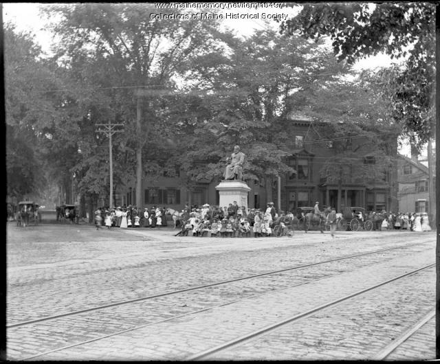
This is just a bit older, circa 1900

15497.JPG

From Maine Memory Network [source]

The reason I wanted to post it is to make a general observation about how many trees used to be downtown. Not only were there more trees, but the trees were much bigger it seems. Surely, some have been lost to infrastructure (sewer, sidewalk, etc) improvements and have been replaced by newer trees, but I can hardly imagine seeing so many full grown trees downtown.

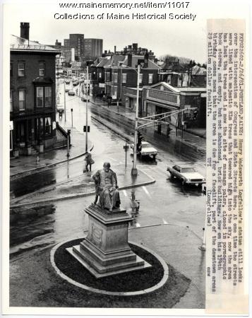
And since that above picture is of a peaceful looking Longfellow Square, here is one from 1981:

11017.JPG


From my perspective, it was a good move to remove that merge lane from Congress onto State and widen the sidewalk. There was a post here on the Rights of Way blog from 2008 that suggests removing a similar merge lane from High to Free Street.

[/random thoughts in thread about pictures from the 40's and 50's]

Corey, I like your random thoughts. :)

My first thought when I saw those photos, before reading your post, was my gosh there are so many trees. That must be from the era when Portland earned the Forest City nickname.

While I don't know for sure, because I am not an arborist, I think those trees might be elm. In that case, the reason they don't exist today is that there was a large elm disease that swept this city (and others), resulting in the removal of these large and beautiful trees all over the city. The eastern Prom used to have a lot more of these trees, too.

One of the key things to remember when planting urban trees these days (so the experts say) is to plant a variety, to make sure if one breed gets sick, the whole city doesn't go bare. I personally would like to see the trees be that big (and more of them!) because I think it adds a sense of enclosure by providing shade and a canopy over the street (if designed correctly). See Greeneville for an example of well planted trees (the trees there led the economic boom of that city). Although I realize there is the counter argument that they block the architecture. Good planning and design should accommodate both interests.
 
Not sure what year this is from, but it caught my eye on the Portland, ME History facebook page. It's prior to whenever the grain elevators on the Eastern Waterfront were torn town.

180610_141725585891876_124967760900992_264424_5829406_n.jpg

[source]

I wonder if the old reservoir by Maine Med was used for ice skating in the winter? Also, I wonder why the land next to Union Station, where the County Jail is now, never developed more as a residential or industrial area. Maybe the area is mostly infill of the Fore River.
 
As for where the county jail is now, I think it is a combination of what you said and the fact that it is next to the tracks, so probably there wasn't a lot of interest in it from housing too. Neat picture!
 
Not sure what year this is from, but it caught my eye on the Portland, ME History facebook page. It's prior to whenever the grain elevators on the Eastern Waterfront were torn town.

180610_141725585891876_124967760900992_264424_5829406_n.jpg

[source]

I wonder if the old reservoir by Maine Med was used for ice skating in the winter? Also, I wonder why the land next to Union Station, where the County Jail is now, never developed more as a residential or industrial area. Maybe the area is mostly infill of the Fore River.

One of the grain elevators was torn down in 1943, so the photo is pre-1943. I can't tell you which one it was from the photo, but I was down there when the last grain elevator burned.

Part of the Union Station train shed is still at Thompson's Point as well, about 1/5th of it was used as a building for Durastone's prefab concrete operation.
 
As for where the county jail is now, I think it is a combination of what you said and the fact that it is next to the tracks, so probably there wasn't a lot of interest in it from housing too. Neat picture!

Where CCJ is now is where the West End dump was located. Almost all of the rest of the land down there was used as a coal yard by the railroad, so may have had some environmental issues. I am going to say those two things alone kept developers away. LOL
 
I wonder if the old reservoir by Maine Med was used for ice skating in the winter? Also, I wonder why the land next to Union Station, where the County Jail is now, never developed more as a residential or industrial area. Maybe the area is mostly infill of the Fore River.

The West End reservoir was not used for ice skating in the winter, it was surrounded by a barb-wire topped chain link fence at least 6 feet high. It was closely watched to prevent kids from swimming in it in the warmer weather too. Don't ask how I know.
 
I want to thank all the folks here who gave their blessing to use the black & white photos here to be re-posted on my FB site "Portland Maine History 1786 To Present". They have been a source of joy for many folks on that page trying to reconnect with how they remember Portland. Many have posted comments, and some comments have digressed to adding even more information about the photo. The site is an ongoing work, and believe it or not, I am running out of sources for photos of Portland that can be re-posted.
Again, Thank you.

John French
 
Some amazing shots from the Library of Congress, found via whatwasthere.com:

4a24255v.jpg


4a23459v.jpg


4a24256v.jpg


This one is Lincoln Park (I thought the others are pretty self explanatory). I love how the park is surrounded by a neighborhood and is densely populated by trees and benches.
4a25705v.jpg
 

Back
Top