Crazy Transit Pitches

Which one's the new bus hub?
At South Station. It looks like it will be double its capacity when the new tower is finished On Atlantic Ave. You could even make it a dedicated busway, to start. If people can promote a ski lift down Summer Street , why not a trolley or dedicated bus down the greenway?
 
At South Station. It looks like it will be double its capacity when the new tower is finished On Atlantic Ave. You could even make it a dedicated busway, to start. If people can promote a ski lift down Summer Street , why not a trolley or dedicated bus down the greenway?

I mean, bus lanes on the Surface Road might be acceptable. I feel like taking parts of the actual park for a trolley might be acceptable to the public, but turning it into roads even if buses-only, probably wouldn't be.
 
I mean, bus lanes on the Surface Road might be acceptable. I feel like taking parts of the actual park for a trolley might be acceptable to the public, but turning it into roads even if buses-only, probably wouldn't be.
Since the Greenway is formally designated a "park", the 4F Federal regulations would apply, which would sink any taking of park land (the Greenaway) for trolleys or bus lanes.
 
Since the Greenway is formally designated a "park", the 4F Federal regulations would apply, which would sink any taking of park land (the Greenaway) for trolleys or bus lanes.

Thanks for that. I suppose stealing some of the Surface Road might still be possible, even if probably not advisable.
 
Thanks for that. I suppose stealing some of the Surface Road might still be possible, even if probably not advisable.
I was looking at this the other day, and I actually don't think the Greenway itself is that useful for trolleys. It's not an uninterrupted ROW by any means, so it would need to duck in and out of the Surface Road anyway. And the Greenway is not super wide -- using it for trolleys would destroy much of the park.

Dedicated lanes on the road are the way to go. Three lanes in each direction -- I have to think that with clever planning a reduction to two lanes could be managed.
 
Dedicated lanes on the road are the way to go. Three lanes in each direction -- I have to think that with clever planning a reduction to two lanes could be managed.

I agree, though I can only imagine the fireworks if it was ever formally proposed. Who's got the popcorn? :cool:
 
Here's my crazy transit pitch for rerouting the Red Line Ashmont Branch only (not the Braintree Branch) into a new tunnel under Dorchester Ave. This would free up space to double track the Old Colony commuter rail line all the way through the Savin Hill area. The reroute of the Ashmont Red Line would also move it a bit inland to allow more pedestrian access from the built-up inland area. It wouldn't be cheap because of all the utilities under Dorchester Ave, if built as a cut-and cover subway. A deep bore tunnel would avoid the utilities. There would be two underground stations at Columbia Road and Savin Hill Ave. The existing Ashmont line from the "malfunction junction" south to where the new alignment rejoins it would be abandoned, and the Braintree Red Line and Old Colony tracks reconfigured through that stretch to double-track the Old Colony line. Here it is:

51434491211_2c5f61900f_h.jpg

Does Ashmont get severed from the Cabot Yard leads in this proposal?
 
Does Ashmont get severed from the Cabot Yard leads in this proposal?
A track connector from the SB Cabot line to the SB proposed tunnel could be squeezed into a tunnel portal between the SE Xway and the rail line just to the north of Boston St, but I'd rather see that space used to add a second Old Colony track.

It was fun coming up with this overall idea, but it isn't a very good one in retrospect. It would be far cheaper and easier to create space for a second Old Colony track thru the Savin Hill area by tunneling a Red Line Branch under the other, which has already been proposed by F-Line at https://archboston.com/community/th...r-north-south-rail-link-nsrl.1089/post-376773. Under that scenario the utility relocations would be nil, and less new tunnel length required than my Dorchester Ave tunnel idea.
 
Last edited:
If you're tunneling, why stop at Savin Hill? Turn that TBM up to 11! Plow four tracks all the way to the Dorchester/Adams intersection, then 2 tracks to Ashmont, and another 2 to Braintree via Neponset -> Hancock -> the parkways.

Overkill in the extreme, perhaps, but what else could you do, take ROW from i-93? Not gonna happen!!
 
Taking ROW from 93 needs to happen. The city and region have set goals for reducing carbon that they cannot meat if they are unwilling to address the primary contributor to carbon emissions in the state, personal transportation. The car does not have a universal right to miles and miles of city/state land in perpetuity. Planning for the car forever is building an infrastructure that encourages ecological destruction. If the state/local cities and towns are serious about meeting climate goals they need to start thinking seriously about what sustainable transit infrastructure looks like.

Single track bottle necking a crucial node in a potential regional rail transit system next to 8 lanes of traffic cannot continue!
 
Last edited:
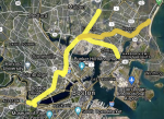
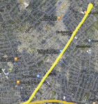
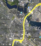
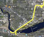
Another proposed line/ set of lines connecting working communities to job centers that are not far but lack reliable connections. The main idea would be to repurpose grand junction as a light rail line. on the southern end it would be connected to Kenmore Sq. with a new bridge or as a later phase continue west through Alston into Watertown or newton. The north is where this would be truly transformative. A line down Broadway in Everett using bus lanes or cut and cover, a line down an extended Silver line busway to the Chelsea river, and perhaps most crazily a line down route 16 to wonderland (unlike my previous southern lines I don't think this ever had a trolly but its a wide enough ROW to fit rail but it may need some complex bridging and tunneling). These would also tie into the green line extension at the MBTA yard after passing under the highways and an expanded rail and pedestrian bridge across the mystic. The routes I imagine would be the Everett and Chelsea lines would run to Kenmore and north station with maybe two trains an hour run in opposite directions as a loop between Kenmore, Back Bay, Downtown, North station, Cambridge Crossing, and Kendall. The North station routes could also easily be through run into southern lines like the existing green line expansion is doing.
 

Attachments

  • Screen Shot 2021-09-08 at 11.08.46 AM.png
    Screen Shot 2021-09-08 at 11.08.46 AM.png
    1.3 MB · Views: 129
  • Screen Shot 2021-09-08 at 11.05.11 AM.png
    Screen Shot 2021-09-08 at 11.05.11 AM.png
    2.9 MB · Views: 112
  • Screen Shot 2021-09-08 at 11.05.28 AM.png
    Screen Shot 2021-09-08 at 11.05.28 AM.png
    1.5 MB · Views: 112
  • Screen Shot 2021-09-08 at 11.05.45 AM.png
    Screen Shot 2021-09-08 at 11.05.45 AM.png
    2.1 MB · Views: 120
  • Screen Shot 2021-09-08 at 11.08.07 AM.png
    Screen Shot 2021-09-08 at 11.08.07 AM.png
    2.3 MB · Views: 113
  • Screen Shot 2021-09-08 at 11.08.37 AM.png
    Screen Shot 2021-09-08 at 11.08.37 AM.png
    3.4 MB · Views: 959
.....and perhaps most crazily a line down route 16 to wonderland (unlike my previous southern lines I don't think this ever had a trolly but its a wide enough ROW to fit rail but it may need some complex bridging and tunneling).
An elevated light rail line along the Route 16 location that you show would work, IMO, The road is plenty wide enough to avoid excessive impacts on adjoining properties:
screen-shot-2021-09-08-at-11-08-37-am-png.16536

The typical section could look something like this:
34115227214_427e6a792c_c.jpg
 
An elevated light rail line along the Route 16 location that you show would work, IMO, The road is plenty wide enough to avoid excessive impacts on adjoining properties:
screen-shot-2021-09-08-at-11-08-37-am-png.16536

The typical section could look something like this:
34115227214_427e6a792c_c.jpg
The big challenge for center median elevated like this is stations. Stations need to be much larger than the profile shown, and have to provide pedestrian access to both sides of the road, including elevator (ADA) access.
 
The big challenge for center median elevated like this is stations. Stations need to be much larger than the profile shown, and have to provide pedestrian access to both sides of the road, including elevator (ADA) access.
I don't believe that would be a problem on this route. All the stations would be adjacent to low density commercial uses (fast food, gas stations, etc.), not near any residential, or in interchanges or rotaries that would not be right next to residential. Here's a map showing the station locations (in orange):
https://www.google.com/maps/@42.394...lsAXD5JAG7DyaF8Wgcd1tkonICFh?hl=en&authuser=0
Edit: Also, the one station that would be directly over Revere Beach Parkway, near Everett Street, could probably be at ground level in a widened median of Revere Beach Pkwy, by acquiring a strip of land from the parking lots/low density commercial on each side and having the elevated structure touch down at the station location.
 
Last edited:
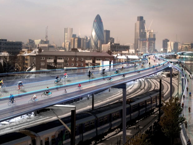
A whole other topic here: elevated bikeways. A proposal for London has elevated bikeways over existing rail lines:
f8bf625c-aa01-4178-9b15-89ef7113c701-1024x768.jpeg


The article is at https://www.theguardian.com/artandd...n-foster-skycycle-elevated-bike-routes-london
I could see a structure like this being wide enough to accommodate separate lanes for e-bikes, unpowered bikes, and pedestrians. With the ease of use of e-bikes, I could see this as a viable commuting mode for a significant group.
 
Last edited:
The main issue there is street access. If the rail line is at or above grade, then you have to built massive ramps (as shown above) to reach the bikeway. That limits the number of locations you can actually access the bikeway, and requires lengthy ramps alongside the rail line - at that point, you might as well build the path alongside the rail line. If the rail line is below grade, then an overhead bikeway intersects all the cross streets.
 
The main issue there is street access. If the rail line is at or above grade, then you have to built massive ramps (as shown above) to reach the bikeway. That limits the number of locations you can actually access the bikeway, and requires lengthy ramps alongside the rail line - at that point, you might as well build the path alongside the rail line. If the rail line is below grade, then an overhead bikeway intersects all the cross streets.
The access ramps could also be spiral, which for a bicycle could take up minimal space due to the tighter radius of a bicycle compared to an automobile.
 
An elevated light rail line along the Route 16 location that you show would work, IMO, The road is plenty wide enough to avoid excessive impacts on adjoining properties:
screen-shot-2021-09-08-at-11-08-37-am-png.16536

The typical section could look something like this:
34115227214_427e6a792c_c.jpg
Route 16 is a corridor from Revere Beach to Fresh Pond that is vital for key travel routes 7 days a week that is regularly backed up with awful car traffic. It's such a main arterial route that should be a highway. Such a good idea for a route connecting key areas
 

Back
Top