Crazy Transit Pitches

MBTA_2140.jpg


Here's my plan. The Indigo Line would be converted to a surface/subway heavy rail line, begiining at Norwood Airport, to the existing Silver Line tunnel at South Station, then under Fort Point Channel and a new under harbor tunnel to Logan Airport, Chelsea and Wellington.

The Blue Line would be extended to Watham/route 128 along an old rail right-of-way, the Orange Line to the Woburn rail station off of I-93, the Green Line to Woburn Center, and the Red Line to the terminus of Route 3 in Burlington. An urban ring woud be developed as a light rail line using portions of the B Line and D Line, looped at Kenmore Square to access the Longmire area and Roxbury. On the north side it would use the Harvard Square bus tunnel, proceed up Mass Ave on the surface to Porter, then connect to the forthcoming Green Line extension at Union Square.

http://maps.google.com/maps/ms?ie=UTF&msa=0&msid= 204339377609299454038.0004921445b226596978c
 
Last edited:
Not bad, although I've never been down with the DC-like/commuter-rail function the T would take on by being extended on all routes to 128.

Why extend Indigo to Norwood Airport? General aviation folks don't need transit. Better to bring it down the ROW that leads to Westwood's 128 Station, where it could serve the new transit village and provide additional access to a convenient express Amtrak stop.
 
How about this, then?

Make a few extensions to the Orange Line.

One extension will be from State Street to South Station, thus allowing for a direct link between North and South stations. Then branch out from South Station towards the Airport Terminal, though it may be a redundant link, when compared to the Blue Line.

Another extension could be a branch either from Back Bay or from Ruggles and could serve the areas of Roxbury that are poorly served by transit.
that shouldn't be an issue
 
Here's a less crazy pitch: sink the E-branch at some point after the NU or MFA stops (basically, as soon as it passes over that underground brook). As a subway, there's no reason why it can't go back down through JP and end at Forest Hills.

Now, besides the usual costs associated with cut and cover (which are, of course, very significant), what problems are there with this plan?
 
MBTA_2140.jpg


Here's my plan. The Indigo Line would be converted to a surface/subway heavy rail line, begiining at Norwood Airport, to the existing Silver Line tunnel at South Station, then under Fort Point Channel and a new under harbor tunnel to Logan Airport, Chelsea and Wellington.

The Blue Line would be extended to Watham/route 128 along an old rail right-of-way, the Orange Line to the Woburn rail station off of I-93, the Green Line to Woburn Center, and the Red Line to the terminus of Route 3 in Burlington. An urban ring woud be developed as a light rail line using portions of the B Line and D Line, looped at Kenmore Square to access the Longmire area and Roxbury. On the north side it would use the Harvard Square bus tunnel, proceed up Mass Ave on the surface to Porter, then connect to the forthcoming Green Line extension at Union Square.

http://maps.google.com/maps/ms?ie=UTF&msa=0&msid= 204339377609299454038.0004921445b226596978c

Love the idea and the extensions. Think we can extend the Orange Line down to Westwood/128, like it was planned in the 70s too? And if that Charles River Island proposed by Ralph Adams Cram is built one day, think we can reroute the Blue Line under the Charles after Charles/MGH to serve that island, and then back under the Charles to serve Waltham?
 
Van...I LOVE your maps. Not just like...but LOVE!


1. The Red Line will be extended out to 128/Brandeis. It'll take some time, and a lot of litigation from NIMBY's. But it'll run alongside the Commuter Rail, which will be okay with most neighbors. The worst will be that they'll just add a commuter rail stop at Alewife.


If they'd recess that line into the ground (Like the orange line in Jamaica Plain) or Commuter Rail in Somerville (at Porter) I'll volunteer to help dig it FOR FREE. The air rights if office buildings are built above it would also help defray costs too. Those commuter rail trains are so noisy and they wall off Cambridge in the most inconvenient of ways. Alewife Parkway to Porter is like a 10 min walk (along the tracks). But to walk around the tracks using Danehy Park plus surface roads it becomes more like 20-30 mins. I'd have to say I'm one of your NIMBYs lol. I'd help dig it though to let it proceed.
 
The population density necessary to support rapid transit drops off quite a bit beyond West Medford. Is it really such a good idea to extend rapid transit service 7 miles (W Med to Anderson) beyond where the density can support it? In order to get there you'd need to pass through tony Winchester, which would almost certainly oppose it (in fact, dense and relatively blue collar Medford has been less than enthusiastic in their support for GLX).

You'd essentially be creating a stretch of Orange Line from Anderson to West Medford that would be about as long as the Forest Hills to Wellington stretch, on which there would be essentially empty trains throughout most of the day, and empty trains coming every 5 minutes during the peak periods in the non-peak direction.

Maybe not as good an idea as you think?

But doesn't it become a chicken and an egg situation. When I spoke with some people internally at the MBTA they seem to think that should that blue line extension ever be done to Lynn it will cease to be an area with property values that are as relatively low as they are...

New subway routes slowly but surely bring more people.

I wonder how Medford will look roughly two-three decades after the green line extension is done.
 
MBTA_2140.jpg


Here's my plan. The Indigo Line would be converted to a surface/subway heavy rail line, begiining at Norwood Airport, to the existing Silver Line tunnel at South Station, then under Fort Point Channel and a new under harbor tunnel to Logan Airport, Chelsea and Wellington.

The Blue Line would be extended to Watham/route 128 along an old rail right-of-way, the Orange Line to the Woburn rail station off of I-93, the Green Line to Woburn Center, and the Red Line to the terminus of Route 3 in Burlington. An urban ring woud be developed as a light rail line using portions of the B Line and D Line, looped at Kenmore Square to access the Longmire area and Roxbury. On the north side it would use the Harvard Square bus tunnel, proceed up Mass Ave on the surface to Porter, then connect to the forthcoming Green Line extension at Union Square.

http://maps.google.com/maps/ms?ie=UTF&msa=0&msid= 204339377609299454038.0004921445b226596978c

I love the idea... A northern branch I think could be the basis for expanding into areas between Route 2 + 128. Namely
A Newton Corner, Watertown Sq., Belmont Centre, Arlington Center, Medford Square, Malden Center, to the (Blue line) would help to fill out the population numbers IMHO north of Boston. And help take quite a bit of pressure off I93 Northbound in the evenings...
I knew someone that was having car trouble for a while and used to commute from Haverhill to Newburyport but because there are no connections between those 'spokes' they had to commute the 1.25 hours to North Station and then the 1+ hour to Newburyport. (plus waiting time at North Station.)
 
5452408242_7d2fd43523_o.png


5451797153_23cfb39ec9_o.png


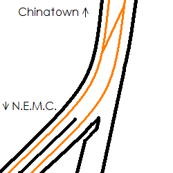
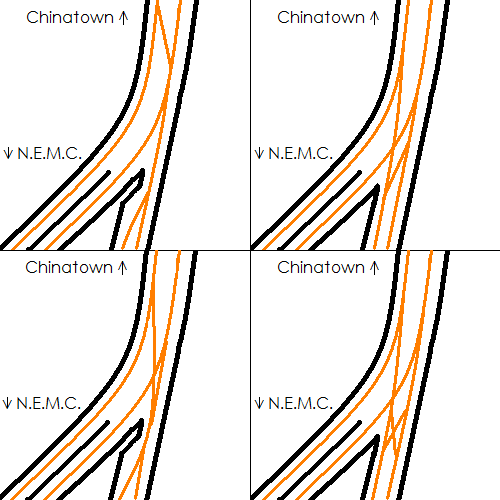
My proposal for being able to pull dead trains off when they're in the downtown area. Could also store an extra set or work equipment in there (like the workers' LRV between Boylston and Arlington). The Orange Line constantly has problems and downtown has a lack of crossovers. The tunnel is already there from the old alignment, the only questions is if it's long enough to shove a train in.
 
That is a great idea (I think the first one makes the most sense). The MBTA probably considered this when they closed the Washington St El so I wonder why they didn't go for it.
 
That is a great idea (I think the first one makes the most sense). The MBTA probably considered this when they closed the Washington St El so I wonder why they didn't go for it.

My guess is back then, they rarely had the major breakdowns as often as today with the old fleet. But even when a new fleet comes in this would be a good measure for any emergency.
 
Question: is it at all possible to create a branch from State Street to South Station?

Or would there have to be a split in the lines just before State, with the Orange Line branch to South Station having to be either further below the ground or elevated?
 
I think a more important South Station connection would be from the GL at Boylston, under Essex St - the original Silver Line III tunnel proposal. This would also be great for the GL as it could then be routed directly into the SL tunnel.
 
I think a more important South Station connection would be from the GL at Boylston, under Essex St - the original Silver Line III tunnel proposal. This would also be great for the GL as it could then be routed directly into the SL tunnel.

So essentially, the stops would be Boylston, then Chinatown and then South Station?

It would be kinda fun to then extend that line further to make a direct, if redundant, link to Logan Airport.

Essentially, the Green Line would be hitting all the three important transit terminals in the city.
 
Overload the Green Line even further? It's probably the least ideal vehicle type for transporting people with big bags to the airport. And how would it go through the tunnels?
 
Not only that, but so what if the Green Line hits North Station and South Station? If it goes to South Station, they would most likely go with a PO Square extension type of plan at Boylston. That means you'd come south from North Station and have to transfer at Arlington to go to South Station. Might as well take the Orange/Green to Red.
 
^ Greenway trolley. See my integrated vision on the previous page.
 

Back
Top