Crazy Transit Pitches

Doesn't seem like it's worth it. The LMA area is pretty self contained... it's not even a mile between where D and E is. People from the burbs taking the CR would be helped with better access from Ruggles or Lansdowne but I think most people would just continue to take D or E and just walk.

Part of the problem today is that the service is split between the D and the E. Service every 8 minutes on each of those branches doesn't equal an experienced headway of 4 minutes when going inbound. With "traditional" D-to-E, especially with an extension to Hyde Square or even Arborway, the majority of service would end up being on Huntington rather than Highland, so most people would just gravitate there.
 
I was digging through the early pages of this thread and came across what apparently was my first true "Crazy Transit Pitch", which involved replacing the Inner D with Blue, and building out from there. It certainly lived up to the thread title:

1663697550330.png


Lots of wild stuff in here that I would not do now (although a few things that still have merit), but one interesting thing is the way that I sliced up the Green Line branches. One thing I do like about this map was my HRT "Airport Line" (in magenta), connecting Logan, Seaport, South Station, Back Bay, and Longwood, before heading out into the heart of Allston-Brighton. Cutting across Brookline would be wildly expensive and not worth it IRL, but I like how I treated it as an aggressively linear corridor: Longwood-South Station deserves a rapid transit spine, and the trajectory across Brookline is the most straight shot (and hits key nodes in Brookline and Brighton).

But anyway, you can see that I suggested something similar in that I rerouted the lower E across to Washington (though not Nubian) after an interchange around LMA/MFA. In this case, I think it was because I really wanted to give upper Huntington HRT but found it harder to justify on the lower half, and likewise wanted to provide lower Huntington + Arborway LRT a maintained link to the Central Subway.

I think the idea maybe has some merit for a branch that terminates around Heath St, or continues west toward Brookline, but I think Arborway - LMA - Ruggles - Washington just becomes too roundabout, and what's more diverts away from the Pru and Back Bay.
As has come up in the bus network redesign, one of the biggest failings of the existing subway network is that it doesn't serve the center of the LMA - because the LMA is a relatively recent addition to the city. Two different ways to get a station in the center of the LMA have been rattling around my mind. Both of them attempt to accommodate an E extension to Hyde Square, which often gets ignored in D-E pitches.

Pitch 1: D-E connector via Longwood Avenue
View attachment 28550
Bury the E from Northeastern to somewhere past Longwood Avenue, with new subway stations at Northeastern and Wentworth/MFA. Built a new tunnel from the D under Longwood Avenue, with new subway stations at Brookline Avenue and Avenue Louis Pasteur. It's a bit longer than other D-E connector designs, but it gets two stations in the heart of the LMA. It also allows for the outer E to come to the surface wherever is convenient.

This also lends itself to adding a wye with the Highland Branch and a short connector up Ruggles Street, getting you a circumferential Kenmore-Ruggles route that improves LMA access from the B, C, and Orange Line.

Pitch 2: Blue Line extension
View attachment 28551
Extend the Blue Line to Kenmore, then under Brookline Avenue and Longwood Avenue. Briefly follow Huntington Avenue (a second deck under the E tunnel, if that's built), then deep-bore to Ruggles and Nubian. If desired, you can also build the D-E connector, and send a southern branch of that tunnel to surface near Heath Street.

This one would be a LOT of tunneling - about 4.6 miles for the Blue Line alone. But it gets you Red-Blue, a second east-west subway, subway stations for Fenway-Kenmore and LMA, a southwestern circumferential line, and returning Nubian to the rapid transit network. It can also be built in phases - every additional station past Kenmore is an excellent value on its own. For extra points, have the Kenmore BL platforms under Brookline Avenue, with a second entrance at Lansdowne station.

The main downsides are that it likely eliminates extending the Blue Line west towards Allston/Watertown/Waltham, and that it wouldn't actually make for a faster ride Nubian-downtown than a slightly improved Silver Line.
Also in the course of my digging, I found that @vanshnookenraggen proposed something very similar to your option 1 waaaaaay upthread (I have since misplaced the post, and Google isn't helping, alas). I think it's a solid idea -- I had similar network design thinking with my surface proposal a few weeks ago. It also will be incredibly tunnel-heavy, with concurrent cost and complexity. Honestly, I don't know if we've really hashed out an LRT cut-and-cover subway under Longwood Ave, but it strikes me as a prime example of "very expensive idea that potentially could deliver commensurate value" -- high-cost-high-benefit.

The question is how it matches up against a surface LRT alternative like I proposed above, a surface BRT/transitway alternative along Longwood Ave, and a traditional D-E connector to the southwest. And I think that hinges on the actual complexity of a tunnel.

As for Blue Line: I talked about this possibility a bit in my Blue Line series. I could be convinced of a wraparound to Longwood and Nubian, but I am increasingly leaning toward heading toward West Station in the long-run (longer explanation of my general philosophy on this topic here).
 
Two years ago (nearly to the day), @The EGE suggested that a long-term vision for the Foxboro branch would be to extend it to Mansfield, and I pooh-poohed it:
As much as I love service to Mansfield via Foxboro from a crayon map perspective, the only way it could make sense is in a 100-year future where 495-land is as dense as 128-land is now, and where there's a fundamental reimagining of downtown's like Mansfield to be highly transit-oriented, combined with the presence of significant employment centers in Foxborough, Norwood and Dedham.

The biggest problem right now is that Mansfield's lot fills up utterly and entirely during rush hour. There is some TOD, and some potential for more, but not a lot more. And you're not going to siphon off many Boston commuters, unless you're willing to offer a major price discount, because the travel time is much worse (see below). So at most you'd be pulling in more commuters who need to park, which aggravates the original problem further.

At best, running largely non-stop, a train from Foxborough Patriot Place takes 45 minutes to get to South Station. Tack on another 5 minutes to travel to Mansfield, and your travel time from Mansfield to South Station clocks at 50 minutes. By contrast, a mid-day local from Mansfield via the NEC, stopping everywhere including Canton Junction and Hyde Park, clocks in at 44 minutes. Pre-pandemic, the morning expresses from Mansfield -- making about as many stops as the 45-minute Foxborough Express -- clocked at 36 and even 31 minutes on the timetable.

(A Foxborough Local, pre-pandemic, was timetabled at 55 minutes, which would make it an even hour from Mansfield.)

60 minute local/50 minute express vs 44 minute local/36 minute express -- in both cases, traveling via Foxborough adds about 37% to your travel time.

Now, strictly speaking, from a crayon map perspective, you possibly could have a little more success running trains the other way -- from Foxborough (or even north) south to Providence. At least there you're not hampered by a significantly slower route, and there probably is a bit more potential for "reverse" commute patronage, at least from as far as Attleboro.

I mean, it's still not much. And of course you'd still have the same parking problem. And if you are gonna run RIDOT trains up the NEC to Attleboro, it's probably better to send them to Taunton, Fall River and New Bedford, the last two having an honest-to-God commuting corridor with Providence.

As with so many transit things, alas.

I'm revisiting this idea, and changing my view, prompted by looking at where the jobs actually are along the Route 1/Route 95 corridor:

1664630985762.png


1664631020996.png


With remarkable fidelity, the string of job densities run along the Northeast Corridor up to Mansfield before diverting west to run along the Foxboro & Franklin Line. This mirrors the population density map:

1664631861140.png


In thinking about a Mansfield-Foxboro-Boston rail service two years ago, I had been focusing on Mansfield + Foxboro as suburbs of Boston. But I have recently been thinking about what it will take to de-center the automobile in New England suburbs, and have concluded that we need to look for ways additionally to support collective transit journeys within the suburbs that aren't oriented toward major cities or necessarily to employment-oriented commutes.

In some ways, the Highland Branch offers a compelling model: a string of medium-density villages with reasonable walkability and predictable (even if not maximally frequent) public transit connecting them, enabling "village hopping" journeys.

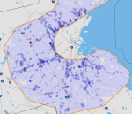
Not all of Boston's suburbs could fit such a model; many feature large density cavities, and only a few feature this characteristic string of "islands":

1664632843907.png


But I would argue that Providence-Mansfield-Norwood-Dedham represents a strong opportunity to reimagine the New England suburb into one that offers bona fide collective transit alternatives to private auto ownership, achievable via modest density increases in "downtowns" but leaving intact the overall character of the communities.

From a transit perspective, this would be achieved by a relatively straightforward expansion of the Regional Rail model: take your every-30-min Foxboro trains and extend them down to Providence via the NEC. This would create half-hour frequencies for journeys within the Route 1 corridor "islands", supplementing faster direct service to Boston and Providence within the appropriate commuter corridors.

Additionally, because of the pattern of diverging vs joining junctions at Walpole, Mansfield, and Canton, the southbound Foxboro trains would be able to use up the slots vacated by South Coast trains peeling off at Canton Junction. Finally, in addition to doubling up with Franklin trains at Walpole to provide 15-minute headways to Norwood and Dedham, Foxboro trains would double up with Providence trains to provide 15-minute headways to Mansfield, the Attleboros, and Pawtucket, creating a legitimate Urban Rail corridor running into Providence. (Mansfield is somewhat at the extreme of this, but Attleboro is well-enough in Providence's sphere to benefit from frequent service.)

1664635527310.png


To be clear, these through-running Foxboro trains would not be used (south of Foxboro) for commutes into Boston. This route is made of three segments, roughly corresponding to "within 128", "between 128 & 495", and "outside 495":
  • Boston-Readville
  • Readville-Norwood-Mansfield
  • Mansfield-Providence
This service is meant to enable within-corridor journeys through two of those segments, stringing together a series of overlapping markets:
  • Traditional Fairmount/Franklin commute to Boston
  • Reverse commute to Dedham, Norwood, Walpole, and Foxboro
  • Southerly commute from Norwood, Walpole, Foxboro, Mansfield, and Attleboro to Providence
  • Northerly commute from Mansfield, Attleboro, and Rhode Island to Foxboro, Walpole, Norwood, and Dedham
  • Suburb-to-suburb journeys along the corridor of higher density population and jobs from Attleboro to Dedham, supporting both work and non-work trips
Living in walking distance, for example, of Mansfield station would afford car-free access not just to downtown Mansfield, but equally to the downtowns of Attleboro, Patriot Place, Walpole, and Norwood. This would also reduce the pressure on each individual downtown to be fully self-sufficient.
 

Attachments

  • 1664635208382.png
    1664635208382.png
    365.3 KB · Views: 39
Again, using the Mansfield example: the walk from a TOD apartment in downtown Mansfield to the nearest grocery store is 20 mins long, and requires crossing Route 140; alternatively, frequent rail service would enable someone to ride the 18 minutes to South Attleboro, use the Market Basket right near the station, and return back in similar time, without carrying groceries a mile on foot. Likewise, a car-less resident of Mansfield looking for a matinee entertainment could simply hop onboard and ride a stop or two to Patriot Place to see at film at the Showcase Cinema there.

Travel times between Boston and Providence would not be useful, but journey times within those overlapping markets listed above would all be reasonable:
Station​
Southbound Travel Time​
South Station
0:00
Fairmount​
0:23​
Readville​
0:28​
Dedham
0:34
Norwood Central​
0:42​
Walpole​
0:50​
Patriot Place​
0:59​
Mansfield
1:12
Attleboro​
1:20​
South Attleboro​
1:30​
Pawtucket​
1:35​
Providence
1:40
Station​
Northbound Travel Time​
Providence
0:00
Pawtucket​
0:23​
South Attleboro​
0:28​
Attleboro​
0:34​
Mansfield
0:42
Patriot Place​
0:50​
Walpole​
0:59​
Norwood Central​
1:12​
Dedham
1:20
Readville​
1:30​
Fairmount​
1:35​
South Station
1:40
(These journey times are based on current schedules, with a best-guess for Mansfield-Patriot Place, assuming track improvements to passenger rail standards. Further track improvements and electrification likely would reduce these journey times further.)

~~~

To be clear: I do not believe there is demand for this kind of service now. Nor do I believe this service necessarily would convert existing car users to transit. What I do believe this kind of service could do is contribute to an overall reimagining of our suburbs into communities where car ownership is optional, and where downtowns can be revitalized into small lively centers of community life. Over time, this can effect a generational change where people choose to de-prioritize owning a car, and look for places to live accordingly.

This reimagining would need to extend beyond the railroad ROW: we would continue to need TOD, potentially slightly denser than is being done today; local bus service (including school bus service) would need additional investment and improvement; and modest redesigns of the extant built environment would be required in order to prioritize pedestrians. (Case in point: Patriot Place has a lot of great shopping and entertainment, but some of it is located 20 minutes away from the platforms on foot.) The scale of this reimagining is large, but the scope of the specific changes needed is much smaller.

We will never entirely banish automobiles from the suburbs. But I truly believe we can offer an honest-to-God alternative that would offer broad appeal. And I think it would take less than we'd imagine.
 
Assuming it does someday become desirable to extend true rapid transit (in addition to every-15 regional rail) to Waltham, it's probably going to be a choice between Red and Green. Assuming for the sake of argument that Red is chosen, the question becomes how do you get there from Alewife? The whole station complex was built to accommodate the alignment to Arlington, with a fairly tight curve just west of the platform that makes a flying junction nigh-impossible, never mind the difficulty of tunneling under the garage.

My solution: run the Waltham-bound track along the original Fitchburg Cutoff ROW, with a platform north of the existing platform, and duck under the existing tail tracks. The new inbound track avoids the spiral ramp and runs under as little of the garage as possible. This lets you run branches to both Arlington and Waltham (every 6 minutes should be fine for both), with all inbound trains using the same platform. All of the tunneling (except where the inbound track curves into the station) is under old rail ROW, avoiding buildings and as much wetlands as possible. You only touch revenue tracks at two points (the outbound junction and where the connecting passageway connects to the existing station) so it could be build with minimal interruption to revenue service.

1665866846761.png


1665866891504.png
 
Having the additional platform so far away isn't ideal, but the general concept is brilliant. Since there isn't basically nothing there now, you could break the northbound track off closer to the existing station and have it as a lower level.
 
Assuming it does someday become desirable to extend true rapid transit (in addition to every-15 regional rail) to Waltham, it's probably going to be a choice between Red and Green. Assuming for the sake of argument that Red is chosen, the question becomes how do you get there from Alewife? The whole station complex was built to accommodate the alignment to Arlington, with a fairly tight curve just west of the platform that makes a flying junction nigh-impossible, never mind the difficulty of tunneling under the garage.

My solution: run the Waltham-bound track along the original Fitchburg Cutoff ROW, with a platform north of the existing platform, and duck under the existing tail tracks. The new inbound track avoids the spiral ramp and runs under as little of the garage as possible. This lets you run branches to both Arlington and Waltham (every 6 minutes should be fine for both), with all inbound trains using the same platform. All of the tunneling (except where the inbound track curves into the station) is under old rail ROW, avoiding buildings and as much wetlands as possible. You only touch revenue tracks at two points (the outbound junction and where the connecting passageway connects to the existing station) so it could be build with minimal interruption to revenue service.

View attachment 29593

View attachment 29594
A couple of us have talked about Blue to Waltham via a Riverbank Subway, (along a reduced Storrow Drive), then West Station and Watertown. But I like your idea for the Red Line. That's the neighborhood I grew up in, so I give my stamp of approval, LOL.
 
Assuming it does someday become desirable to extend true rapid transit (in addition to every-15 regional rail) to Waltham, it's probably going to be a choice between Red and Green. Assuming for the sake of argument that Red is chosen, the question becomes how do you get there from Alewife? The whole station complex was built to accommodate the alignment to Arlington, with a fairly tight curve just west of the platform that makes a flying junction nigh-impossible, never mind the difficulty of tunneling under the garage.

My solution: run the Waltham-bound track along the original Fitchburg Cutoff ROW, with a platform north of the existing platform, and duck under the existing tail tracks. The new inbound track avoids the spiral ramp and runs under as little of the garage as possible. This lets you run branches to both Arlington and Waltham (every 6 minutes should be fine for both), with all inbound trains using the same platform. All of the tunneling (except where the inbound track curves into the station) is under old rail ROW, avoiding buildings and as much wetlands as possible. You only touch revenue tracks at two points (the outbound junction and where the connecting passageway connects to the existing station) so it could be build with minimal interruption to revenue service.
Great thinking, very nice. I think the Red Line concept continues to be problematic further west, but this seems like a potentially feasible way to handle Alewife. (But yes: I think the order of operations is: Generation 1 - Regional Rail, Generation 2 - Indigo Line via NSRL, Generation 3 - Green Line, Generation 4 - Red Line, if we ever get there.)
 
Would converting the Fairmount Line to rapid transit or light rail and extending it into the Seaport via the existing Silver Line tunnel be A) Possible, B) Useful and C) Reasonably cost effective compared to alternatives?

I remember reading (I think from F-Line) that extending the Green Line tunnel from Boylston to South Station, connecting to the existing Silver Line station, and then extending it through the Seaport was not physically possible. But I'm wondering if it's doable as part of a Fairmount Line conversion? From a political standpoint, it seems like connecting some of Boston's most diverse (and underserved) neighborhoods directly to one of Boston's most notoriously homogenous and affluent neighborhoods would be a good sell. But I don't know if existing infrastructure (O'Neill Tunnel, Red Line Tunnel, Fort Point Channel, etc.) makes it impossible or prohibitively expensive.
 
Would converting the Fairmount Line to rapid transit or light rail and extending it into the Seaport via the existing Silver Line tunnel be A) Possible, B) Useful and C) Reasonably cost effective compared to alternatives?

Dunno if there's room for an extra set of tracks but what's there now is also used by Amtrak and even other CR lines use it.
 
Would converting the Fairmount Line to rapid transit or light rail and extending it into the Seaport via the existing Silver Line tunnel be A) Possible, B) Useful and C) Reasonably cost effective compared to alternatives?

I remember reading (I think from F-Line) that extending the Green Line tunnel from Boylston to South Station, connecting to the existing Silver Line station, and then extending it through the Seaport was not physically possible. But I'm wondering if it's doable as part of a Fairmount Line conversion? From a political standpoint, it seems like connecting some of Boston's most diverse (and underserved) neighborhoods directly to one of Boston's most notoriously homogenous and affluent neighborhoods would be a good sell. But I don't know if existing infrastructure (O'Neill Tunnel, Red Line Tunnel, Fort Point Channel, etc.) makes it impossible or prohibitively expensive.

Green from Boylston to SS/Seaport is very physically possible. We've discussed it at length in the Green Line Reconfiguration thread. You just can't use the route down Essex St. that Silver Line Phase III attempted to, because the cost blowouts of a deep-cavern Boylston Station, tri-level Chinatown station, and building mitigations along very narrow and densely-abutted Essex ended up proving lethal to that project. Attempting the same with light rail would impale itself on the same blowouts. There are, however, multiple other street and station trajectories that would work better for less pain and suffering, and being able to re-use the old outer-track approaches at Boylston is paramount for cost control.

The problems with taking Fairmount off the RR network are manifold. 1) Franklin/Foxboro can't each get clock-facing :30 min. Regional Rail service levels being attached to the Northeast Corridor; it's too congested. Fairmount is needed in load-bearing capacity to provide those frequencies. 2) It's the last southside freight route into Boston. If there's going to be any Port freight rail futures, they'll be routed via Readville Yard and the Fairmount Line. 3) Commuter Rail's southside maintenance facility is slated to be built at the T's Readville Yard 2 facility, meaning the Fairmount Line takes on utmost importance for southside equipment moves.

Plus there's the whole conundrum of how you connect anything rapid transit to Fairmount. The Amtrak Southampton Yard maintenance facility sits in the way at the north end, and the rump end of the North-South Rail Link's Old Colony approach tunnel makes a subway hook-in fairly difficult.
 
F-Line addresses whether it's possible and cost-efficient -- let me take a stab at whether it would be useful.

First, we need to consider what we mean by "useful". In an absolute sense, almost any form of transit (especially in a dense area like metro Boston) is going to have some usefulness. Are there Fairmount Line-Seaport commuters who would benefit from a one-seat ride? Almost certainly. But I don't think that's a really informative measure.

There's a reason most transit studies present multiple alternatives: comparisons are the name of the game here. So, the question isn't, "Is Indigo to Seaport useful?", it's "Is Indigo to Seaport more useful than the other options?"

There are probably three broad alternative options we might consider when asking what to do with the northern end of the "Indigo Line":
  1. Continue to terminate at South Station
  2. Travel along a Central Artery-aligned NSRL
  3. Travel along a new subway under Congress St
Indigo-to-Seaport probably beats Option 1, but how does it fare against the other two options? Not well, in my opinion: options 2 and 3 provide direct transfers to the Orange and Green Lines, as well as northside commuter rail (reverse commutes to Waltham, etc); depending on the build, these options might also provide transfers to the Blue Line. None of that is available with the Seaport option (except perhaps for a 100-year vision of a new harbor tunnel extending the Indigo from Seaport to the Blue Line in East Boston).

What about jobs?

OnTheMap counts 36,000 jobs in the walkshed of Courthouse and World Trade Center. (Another drawback of heavy rail/mainline rail in the Transitway is that you can't run a surface extension to Design Center.)

1666315286728.png


What about in downtown? Here it makes a difference whether there is an intermediate stop connecting to the Blue Line; if your walkshed is limited to North Station, OnTheMap estimates about 20,000 jobs:

1666315741896.png


Including an intermediate stop that connects with the Blue Line (and therefore is located closer to the core of the Financial District) raises that number significantly, to at least 44,000:

1666315926221.png


So, the jobs comparison isn't super decisive -- there are versions of Options 2 & 3 which would serve fewer jobs, but likewise there are versions that serve a lot more jobs, so the "ceiling" is potentially higher.

And of course, an alignment to North Station opens you up to further extension north along one of the northside lines -- for example extending to Porter, a one-stop transfer away from Harvard, which itself has at least 35,000 jobs. The Seaport alignment really has nowhere else to go afterward -- except for that 100-year tunnel under the harbor.

So, Indigo-to-Seaport does
  • worse on transfers
  • equal or worse on job access
  • worse on future extensibility
And then we can do a quick comparison of other ways of serving the Seaport -- LRT from the south (coming from Tufts Medical Center area) and potentially BRT from the north (Congress). For anyone not on the Fairmount Line, these alternatives would be at least equal if not better -- transfer at South Station either way. (And recall the aforementioned bonus of surface transit being able to reach all the way to Design Center.)

So, Indigo-to-Seaport does worse against other Indigo options, and it does worse against other Seaport options. It's definitely a creative idea! And worth consideration -- but ultimately I think fails to make a convincing case on the usefulness front.
 
If we remove the practical considerations made by F-Line that would doom mode change on Fairmount, l think the “usefulness” component could be satisfied by routing the Fairmount “backwards” into South Station via the haul road as light rail. Would allow one seat access to the seaport and financial district, or even Back Bay and North Station depending on how the transit way is tied into the GL.

An interchange with Broadway under fourth street could be provided to not overly penalize passengers headed to South Station. The existing haul road bridge over the Old Colony could even potentially be repurposed.

The only engineering challenge would be how to tie into the transit way. Either some janky surface level alignment on D street from the portal or a deep bore under the pike. Or an even more circuitous routing via silver line way following the entire length of the haul road.

6CC368B3-DF4B-4660-BFBB-2C42778D99DF.png


l christen it, The Questionable Line!(?)
 
Last edited:
I think it's important to note here that Fairmount-Seaport as "Indigo" shotgun marriage was already proposed during the Olympics farce as yet another way of making Track 61 a 'thing', and the backlash was pretty fierce to that in Dorchester and Hyde Park. They want their one-seat to South Station, and Seaport jobs are not at all hard to get to when the Silver Line is right downstairs from SS. Projecting out to the LRT schemes, the sentiment is not going to be significantly better because the SS end point becomes dozen(s) of minutes longer and more convoluted a trip.

The riding public has already spoken loudly about this.
 
Remove all on-ramps and off-ramps for I93 from the Zakim Bridge to Kneeland Street. Turn the greenway into a true greenway.

Make the leftmost lane of the central artery each way into commuter rail tracks for a NSRL.

No new tunnels needed.

Biggest issue is stations for the new regional rail tracks. You could do stations anywhere the central artery is 5 lanes wide, and just turn it into 3 lanes. Without any exits anything more than 3 lanes is unnecessary.
 
Last edited:
Remove all on-ramps and off-ramps for I93 from the Zakim Bridge to Kneeland Street. Turn the greenway into a true greenway.

So, almost-completely render the artery's significant intended function as an arterial road into the city useless? I guess all of the CR stations will sprout expanded parking lots for all the drivers who can't deal with the ludicrous traffic that would result if all those exits got shut. (Not that it wouldn't be nice if they Greenway didn't have quite so many roads running through it.)

Make the leftmost lane of the central artery each way into commuter rail tracks for a NSRL.

Well, the tunnel isn't tall enough to fit the T's coaches and locomotives, so even if it were already structurally capable of handling a railroad (I have no idea whether it would be) it'd have to be significantly modified just to let the trains fit. Add to that the fact that it's not on-alignment for any existing tracks to get to the tunnel, so those approaches would have to be rebuilt. (And while I could conceivably see ways of doing that if you deleted ramps and cannibalized the outermost lanes, getting to the innermost lanes, particularly around North Station, seems like it might actually be impossible without severing the highway.)

Biggest issue is stations for the new regional rail tracks. You could do stations anywhere the central artery is 5 lanes wide, and just turn it into 3 lanes. Without any exits anything more than 3 lanes is unnecessary.

Well, without exits in town, the entire tunnel's probably unnecessary as a road. If everyone has to pour off it onto the surface streets at Leverett and/or North Station and at Kneeland, it'll be a useless mess at all rush hours.

This isn't a crazy transit pitch, this is God Mode territory. It's quite likely to be actually impossible, let alone politically infeasible, and provides next to no actual transit benefit, as the only thing it has going for it is that it would be a cheaper (albeit much worse) NSRL. As a God Mode idea, smiting the Central Artery is fine, but I think this idea belongs in that thread, not here.
 
Well, the tunnel isn't tall enough to fit the T's coaches and locomotives, so even if it were already structurally capable of handling a railroad (I have no idea whether it would be) it'd have to be significantly modified just to let the trains fit. Add to that the fact that it's not on-alignment for any existing tracks to get to the tunnel, so those approaches would have to be rebuilt. (And while I could conceivably see ways of doing that if you deleted ramps and cannibalized the outermost lanes, getting to the innermost lanes, particularly around North Station, seems like it might actually be impossible without severing the highway.)
Not tall enough, and the tunnel grades are also way too steep for FRA rolling stock.
 
So, almost-completely render the artery's significant intended function as an arterial road into the city useless? I guess all of the CR stations will sprout expanded parking lots for all the drivers who can't deal with the ludicrous traffic that would result if all those exits got shut. (Not that it wouldn't be nice if they Greenway didn't have quite so many roads running through it.)
I think it's a failure of the 20th century planning to increase highway capacity downtown so that more people drive to downtown Boston which is in no way shape or form equipped to handle traffic.
 

Back
Top