Do You Recognize These Boston Buildings?

kmfowler

New member
Joined
Aug 24, 2012
Messages
4
Reaction score
0
My grandfather Dorman Milligan Hillier was a general contractor in Boston in the mid-1910's. He was an early "expert" in the construction of steel reinforce concrete highrise buildings/ships. Apparently he built some of the first highrise (8-stories!) buildings in Boston. The photos below are of two buildings he built during that time period. I would like to determine if they are still standing.

He also build the 8-story building at 131 Clarendon Street next to One Back Bay. I have his costs/bid for the work that he typed on a single letter-sized piece of paper. Price of the an 8-story building in about 1916: $242,749.60.

Another structure he built is now called Lofts Avana at 46 Beach Street, and it is almost identical to the building at 131 Clarendon Street. I would guess it was built with the same set of plans and for about the same cost. I have a number of photos taken during construction. That building had two stories added to the top of it in about 2007, when it was already 90 years old.

If you know the location of the buildings in these photos, I would love to hear from you. Thanks... K M Fowler, Seattle, WA

three_pics.jpg
 
I recognize the first building, listed as Stewart-Warner Speedometer Case Co. It's in Packard's Corner--the intersection of Comm Ave and Brighton Ave.
 
There is a Massachusetts court case from 1916 that gives an address of Columbus Ave for Stewart Warner, no number. First floor used as a store and office, basement was a repair shop. Basement opened at grade in the rear to an alley.
 
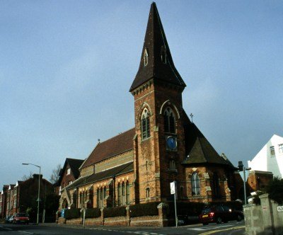
Definitely Packard's Corner, it has a big Comm Ave Associates sign on the front now. The church there is St Luke's.

http://www.bahistory.org/PackCornHist.html

http://www.bahistory.org/PackCornArch.html


The group of one and two story commercial buildings at the apex of the triangular block, delineated by St. Luke's Road, and Brighton and Commonwealth Avenues housed several stores selling motor vehicle related products. The 2 story tapestry brick building numbered 1103-1115 Commonwealth Avenue and 4-18 Brighton Avenue was developed by William H. Burger between 1910-1915.
 
This is St. Luke's. It does not resemble the church in the old photo.

st_lukes_brighton.jpg

Not at all the same St Lukes: http://goo.gl/maps/FSZGG

And its absolutly the Comm Ave Associates building:http://goo.gl/maps/k81nH

Look at the brick detailing: http://goo.gl/maps/LTv80

This is practically a shot for shot image of the middle pic:
http://goo.gl/maps/XvSSn
You can clearly see the Packards dealership, now The Atrium in the back right.

If that wasn't enough, you can see today's B line running raised in the reservation just as it does today in the middle pic, and the former A line in the top picture.
 
Painting masonry and not providing sufficient reveal with replacement windows to maintain shadow lines tends to do that to older buildings. B&W photography also tends to accentuate depth more than color photography because of the way humans perceive shadows in relationship to depth.
 
Nice one, Lurker. That second one was driving me nuts. Are these NEU dorms now?
 
Lurker, great find.

The red brick building at frame right is still standing, and they apparently never filled in the lot where all the signs are billboarded.
 
Nice one, Lurker. That second one was driving me nuts. Are these NEU dorms now?

716 Columbus is owned by Northeastern and houses Human Resources, Mail Services, and the alumni center, but it's not a dorm.
 
You guys are amazing! I never imagined anyone would be able to figure out the location of the buildings so quickly. Thank you very much.

On the question of St. Lukes Church, there are three buildings at the site. If you google on "7 Luke's Road, Boston, MA" you'll find the side of the church visible in the old photo.

I found two more photos that may be an even more difficult test of your skills:

photo 4:
boston4.jpg


photo 5:
boston5.jpg
 
Definitely Packard's Corner, it has a big Comm Ave Associates sign on the front now. The church there is St Luke's.

The 2 story tapestry brick building numbered 1103-1115 Commonwealth Avenue and 4-18 Brighton Avenue was developed by William H. Burger between 1910-1915.

I found a photo of William H. Burger at http://1898revenues.blogspot.com/2012/05/new-york-stock-brokers-william-h-burger.html

Wm.+H.+Burger+&+Co.,+William+H.+Burger.bmp


He looks like the guy standing in front (third from left) in the photo:
hillier2.jpg


This is the globe and eagle seen in the photo at the top of this page.

I wonder if the two men on the left are the engineer and architect???
 
The text in the background of the first of those images looks like AND WOM*N... what could that be?
 
About 70 years early for it to be Brigham and Women's...no idea on that one, but the housing in the background makes me think it's in that area, backing up to Mission Hill or JP somehow.

If the last photo really is facing north, a good possibility would be Cummington Mall (né Street, another issue for another thread), with the foreground tracks now taken up for the Pike. The angle is right, at least (http://goo.gl/maps/IjNJa), but none of the buildings standing today seem to match -- so maybe it was a predecessor to one of BU's current engineering buildings.
 
I have his costs/bid for the work that he typed on a single letter-sized piece of paper. Price of the an 8-story building in about 1916: $242,749.60.

Cool stuff KMFowler. If you have time please scan and post the estimate he put together. I'm curious how they bid stuff back in the day.
 
Cool stuff KMFowler. If you have time please scan and post the estimate he put together. I'm curious how they bid stuff back in the day.

OK, good idea; I find it fascinating too... I also have some photos of construction equipment they were using at the time. I can post them in a couple of weeks when I return from travel if anyone is interested.

dorman_m_hillier_estimate.jpg
 
Fascinating.

Regarding the "Eagle" building, when I first saw the image I immediately thought it was the "Packard" building that is now the Shaw's, not the building it actually is.

Does anyone have photos of the Packard building prior to its conversion into a supermarket, et al? It was what, around 2000?

I'm pretty sure the Packard dealership was 1079 Comm Ave, now the Atrium. In the lobby they have a ton of old pictures of the building and packards corner from back in the day. That building was a thousand times more beautiful before the residential conversion.

I think the shaws was a lincoln dealership, but I'm not 100%. Someone should make a map of the old auto mile as to what was what
 

Back
Top