
I
IMAngry
Guest
What a difference a century makes, huh?
Read below what Harrison Avenue looked like, circa 1898.
Source: The Promised Land - by Mary Antin. Boston & New York: Houghton Mifflin Company, 1912 (book is online; I assume it is in the public domain)
http://digital.library.upenn.edu/women/antin/land/land.html
Today Dover Street, now Berkeley Street, is a street almost empty of any buildings, residential or otherwise.
The street starts from under the Southeast Expressway, toward the South End, past Albany Street, Harrison Ave, Washington Street, and Shawmut Ave, and bisects Tremont Street, where it becomes East Berkeley.
Here are some photos from the book.
Union Place (West End)
Wheeler Street (South End)

Harrison Ave (South End)
Bates Hall (Boston Public Library, Copley Square branch)
Union Place is gone, presumably, along with the rest of the West End.
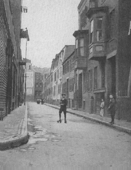
Wheeler Street is gone, too, I assume as part of the same "urban renewal" plan of the 1950s and 1960s (within the New York Streets neighborhood, perhaps?).
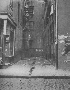
Harrison Ave is still here, of course. I'd make a radical guess that the photo is from Berkeley Street, looking down Harrison Ave, and that the elevated train track is coming out of the (now-abandoned) MBTA storage building.
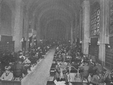
Bates Hall is still here, looks about the same, I'd say, right down to the lampshades (I don't recognize the balcony, though).
Read below what Harrison Avenue looked like, circa 1898.
Source: The Promised Land - by Mary Antin. Boston & New York: Houghton Mifflin Company, 1912 (book is online; I assume it is in the public domain)
http://digital.library.upenn.edu/women/antin/land/land.html
Outwardly, Dover Street is a noisy thoroughfare cut through a South End slum, in every essential the same as Wheeler Street. Turn down any street in the slums, at random, and call it by whatever name you please, you will observe there the same fashions of life, death, and endurance.
Every one of those streets is a rubbish heap of damaged humanity, and it will take a powerful broom and an ocean of soapsuds to clean it out.
Dover Street is intersected, near its eastern end, where we lived, by Harrison Avenue. That street is to the South End what Salem Street is to the North End. It is the heart of the South End ghetto, for the greater part of its length; although its northern end belongs to the realm of Chinatown.
Its multifarious business bursts through the narrow shop doors, and overruns the basements, the sidewalk, the street itself, in pushcarts and open-air stands.
Its multitudinous population bursts through the greasy tenement doors, and floods the corridors, the doorsteps, the gutters, the side streets, pushing in and out among the pushcarts, all day long and half the night besides.
Rarely as Harrison Avenue is caught asleep, even more rarely is it found clean. Nothing less than a fire or flood would cleanse this street. Even Passover cannot quite accomplish this feat. For although the tenements may be scrubbed to their remotest corners, on this one occasion, the cleansing stops at the curbstone.
A great deal of the filthy rubbish accumulated in a year is pitched into the street, often through the windows; and what the ashman on his daily round does not remove is left to be trampled to powder, in which form it steals back into the houses from which it was so lately removed.
The City Fathers provide soap and water for the slums, in the form of excellent schools, kindergartens, and branch libraries. And there they stop: at the curbstone of the people's life. They cleanse and discipline the children's minds, but their bodies they pitch into the gutter. For there are no parks and almost no playgrounds in the Harrison Avenue district, ? in my day there were none, ? and such as there are have been wrenched from the city by public-spirited citizens who have no offices in City Hall. No wonder the ashman is not more thorough: he learns from his masters.
Today Dover Street, now Berkeley Street, is a street almost empty of any buildings, residential or otherwise.
The street starts from under the Southeast Expressway, toward the South End, past Albany Street, Harrison Ave, Washington Street, and Shawmut Ave, and bisects Tremont Street, where it becomes East Berkeley.
Here are some photos from the book.
Union Place (West End)
Wheeler Street (South End)
Harrison Ave (South End)
Bates Hall (Boston Public Library, Copley Square branch)
Union Place is gone, presumably, along with the rest of the West End.
Wheeler Street is gone, too, I assume as part of the same "urban renewal" plan of the 1950s and 1960s (within the New York Streets neighborhood, perhaps?).
Harrison Ave is still here, of course. I'd make a radical guess that the photo is from Berkeley Street, looking down Harrison Ave, and that the elevated train track is coming out of the (now-abandoned) MBTA storage building.
Bates Hall is still here, looks about the same, I'd say, right down to the lampshades (I don't recognize the balcony, though).

