Downtown Crossing/Financial District | Discussion

I'll counter that assertion by pointing out that the built environment of a metro area is directly shaped by innumerable factors other than politics and crime, such as the price of construction materials, but this board finds it possible to not discuss whether the price of steel or concrete will go up or down and how that will affect construction projects in Boston.

Anyway, I apologize for upsetting you, it was unintentional. I'm 61 and accustomed to old-style impersonal no-holds barred debate, and I keep forgetting that we now live in the age of microaggressions and trigger warnings. It's a whole different mindset as to what's allowable in a debate, but I'm afraid I'm too old to change my ways.
iI also apologize if I upset anyone in my earlier posts on this thread. Sometimes I say stupid things, and wish I hadn't. :)
 
When will BronsonShore apologize?

I do think it's a (or 'the'?) problem with contemporary American society that a rising cohort of like-minded people make radical, aggressive statements to politicize everything in life (and to do so, of course, in their preferred political direction). When they are called out or challenged they immediately demand others apologize for having a different opinion. It should be called out as contemptible whenever it rears its head (which is essentially 24/7 now, alas).
 
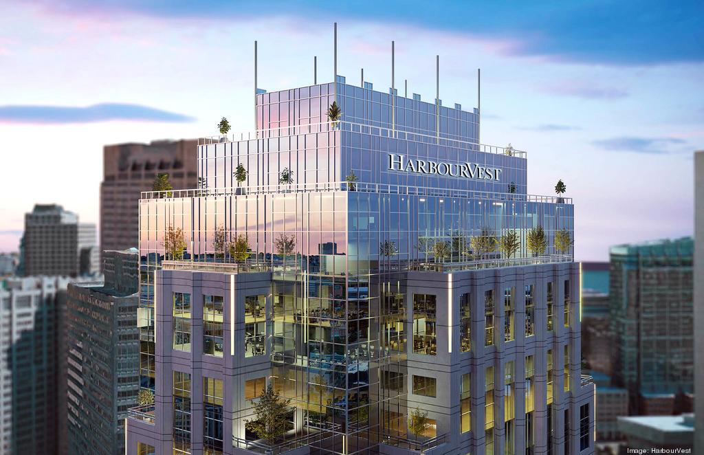
State street getting a new sign:

one-lincolnnew-sign-photo.jpg


I cant read the article so idk what the trees are about.

https://www.bizjournals.com/boston/...?cx_testId=39&cx_testVariant=cx_1&cx_artPos=0
 
I cant read the article so idk what the trees are about.

Just a new tradition in architectural rendering. Trees are de rigueur as symbols of environmental awareness or fighting global warming or sustainability or whatever. The end product very likely won't have any, and even if it does, it won't be long before they're gone. Just like the wind turbines at 888 Boylston.
 
I thought we had a "What would you propose" discussion on Downtown Crossing, but I couldn't find it. I think a nice and fairly inexpensive upgrade would be to have lights all up and down the pedestrian streets, similar to Copenhagen, but MUCH smaller. I'm thinking of lights similar to the trees on Commonwealth Avenue, yet have them up all year long. I know Downtown Crossing has Christmas lights over the street, but this would be year-round and tastefully designed to not look like "decorations."

Encourage restaurants with outdoor seating and roof decks.

View of Copenhagen shopping street:

1724209500883.png


I hate the Orange barriers, but the outdoor seating is excellent here. I really think the whole street should be designed with Outdoor seating in mind.

1724210125913.png
 
I've been in DTX with folks who didn't even notice that that stretch of Washington is supposed to be for pedestrians. Once I was there with friends from out of town and they asked why I was walking in the middle of the road. Once, soon after walking together through DTX, a family member asked if Boston has any pedestrianized areas downtown. I had to explain, yes, that thing we just walked through.

And I understand the confusion. Washington is still designed like a street for cars. Still looks like it. There are curbs and what look like on street parking spaces (sometimes with cars parked in them). There are still road signs. Cars regularly drive down Washington just to cut through DTX. There doesn't seem to be any enforcement around that. I've seen cars drive through DTX and honk at pedestrians to get out of the way. Pedestrians mostly just keep to the sidewalks. It's been 50 years and somehow it's still like this.

Even the modest changes on adjacent Summer Street would make a big difference. Get rid of the curbs. Put planters and tables in the street. And that would already be a vast improvement.

The City has been planning this for years if not decades--this presentation will be three years old in just a few days (and imagine how many months and years prior to it, the City was working on it, even allowing for any COVID-related interruptions):

https://www.boston.gov/sites/default/files/file/2021/10/DTX Public Presentation#1 09-22-2021.pdf

That said, it's hard for me to conceive of a more difficult area to execute technically-feasible design plans, given how DTX is absolutely honeycombed with hollow vaulting beneath the sidewalks PLUS the Orange Line tube running the length of Washington AND the Red Line tube running the length of Winter/Summer.

Coordination with the (presumably) dozens of different property owners who have those hollow vaults, MBTA, Eversource, Veolia, all the telecomm providers, and the collage of easements they all have stacked-up within any cross-section of the area? It won't be easy--but hopefully it gets done at some point in the next few years...
Thanks for that. That presentation from 2021 seems to address everything I was just complaining about, so I'm glad to see someone in city government was working on it. But three years later it's really disheartening to see this in their proposed timeline:

1724253016772.png
 
The City has been planning this for years if not decades--this presentation will be three years old in just a few days (and imagine how many months and years prior to it, the City was working on it, even allowing for any COVID-related interruptions):

https://www.boston.gov/sites/default/files/file/2021/10/DTX Public Presentation#1 09-22-2021.pdf

That said, it's hard for me to conceive of a more difficult area to execute technically-feasible design plans, given how DTX is absolutely honeycombed with hollow vaulting beneath the sidewalks PLUS the Orange Line tube running the length of Washington AND the Red Line tube running the length of Winter/Summer.

Coordination with the (presumably) dozens of different property owners who have those hollow vaults, MBTA, Eversource, Veolia, all the telecomm providers, and the collage of easements they all have stacked-up within any cross-section of the area? It won't be easy--but hopefully it gets done at some point in the next few years...
Wow, the PDF is excellent! It even shows the pedestrian street in Copenhagen I referenced in my post. :) Is this dead? How can we find out the current status?
 
In light of the recent terrorist attack in New Orleans, I think it would be wise to expedite the planned (on hold?) improvements to the DTX pedestrian zone. Adding bollards or barriers is a must, and it would be nice to finally get rid of the curbing.
I actually had this same thought. I know cars do still use the road sometimes, I believe its for deliveries and maintenance? They do make retractable bollards, so may have to use those. Theyre more expensive but allow access when needed.
 
I actually had this same thought. I know cars do still use the road sometimes, I believe its for deliveries and maintenance? They do make retractable bollards, so may have to use those. Theyre more expensive but allow access when needed.

I was in San Diego in October, and they had retractable bollards all along 5th Avenue for about 10 blocks or so. They disappeared and were indistinguishable to the street when retracted. I think they went up around noon every day to make the whole Gas Light District in San Diego a pedestrianized zone. They were really nice. We had a hotel on 5th Avenue, and the Uber pickup/dropoff was on the side street because 5th Avenue was closed most of the time. At the time, I thought this would work perfect for Downtown Crossing in Boston.
 
Behold: a mere . . . 2,725 . . . days* after the state decreed there would be a Downtown planning initiative, the robust (if not exactly rapid) community process lumbers on, with a public meeting on January 15:

https://www.bostonplans.org/news-ca...downtown-and-downtown-zoning-test-amendment-p

*to give just two historical analogies: the Downtown planning process has now stretched on for a longer period than the time between Hitler's absorption of Austria (March 1938) and his April 1945 suicide... it is also rapidly approaching, at 7.5 years, the 8-year time between Operation Rolling Thunder's dramatic escalation of US involvement in Vietnam (March 1965) and the withdrawal of the last US troops from Saigon (March 1973).
 
The yb-52 prototype first flew on april 15 1952. It became operational in 1955 (with side by side seating instead of tandem seating). 3 years from flying prototype to full rate production.

1736486421404.jpeg

https://theaviationgeekclub.com/the...eautification-of-the-us-air-force-museum/amp/

The b-52j which is just going to be a re-engined version of the current b-52h using already existing rolls royce f130 engines that are currently in use on business jets, wont be operational at the earliest until 2033! All theyre doing is taking an existing engine and putting them in slightly bigger pods under the wings and were about a decade away. (Its a tiny bit more complicated than that and theyre adding a couple more off the shelf parts, but Its craziness!) 3 years to go from prototype to production, 10 years (because its already been a few years) just to re-engine them later on. Weve lost the plot.

1736486688639.png

https://www.airandspaceforces.com/gao-b-52j-initial-operational-capability-three-year-delay/
 

Back
Top