kz1000ps
Senior Member
- Joined
- May 28, 2006
- Messages
- 9,186
- Reaction score
- 13,715
Developer hopes for hit at Fenway
Retail residential complex proposed for area between Park Drive, Yawkey Way
By Casey Ross
Globe Staff / September 19, 2008
A developer is proposing his third retail and residential complex outside Fenway Park - a project that would be aided by a new street the city wants to build to spur fresh development in the neighborhood.
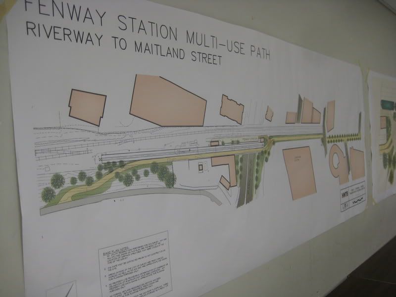
The plan disclosed by Steve Samuels and city officials yesterday is the next step in transforming the gritty triangle between Park Drive and Yawkey Way, where residents and neighborhood planners have long sought to create an "urban village" in the shadows of the ballpark.
Mayor Thomas M. Menino said plans for the new quarter-mile-long street, to run parallel to Yawkey Way, would ease traffic congestion and lay the groundwork for a shopping district where Fenway sausage vendors would intermingle with high-end boutiques.
"What we want to do is have a balance between residential, retail, and some office space," Menino said. "It will be a more walkable area, a more friendly area. Now all you see is auto repair shops and sub shops. That's not the future, that's the past."
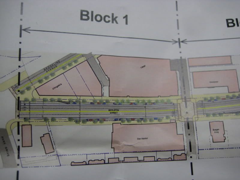
Samuels said his proposed development on Boylston Street would include ground-floor shops, a supermarket, and residential units. He said he has not settled on an exact height for the building, but he pledged to keep it within the scale of the neighborhood.
The proposal comes amid a burst of development around Fenway, much of it by Samuels and his partners. Yesterday, he celebrated the grand opening of 1330 Boylston, a $140 million complex that includes 215 residential units, shops, and offices for Fenway Community Health Center. Samuels also developed Trilogy, a $200 million project of shops and apartments at the corner of Brookline Avenue and Boylston Street.
In addition to his plans, medical group Harvard Vanguard confirmed yesterday it is seeking to develop two parcels around its offices at 133 Brookline Ave. The development could include up to 700,000 square feet of residential and office space, although the precise scope of the proposal remains uncertain.
Gene Wallace, an executive vice president for Harvard Vanguard, said the company has hired the real estate firm McCall & Almy Inc. to gauge developer interest in the property. "We feel this is the right time to assess our options," Wallace said in a statement. "We are enthused about the direction of development in the Kenmore area."
Wallace also indicated Harvard Vanguard expects to remain in its Fenway offices. It is unclear whether it would seek to expand into any new buildings constructed on the property.
Also moving forward is a proposal by developer John Rosenthal to build a $500 million project along Beacon Street. The project, which is being reviewed by city planners, would include a 23-story residential tower over the Massachusetts Turnpike, and three other retail and office buildings. The Red Sox are a minority partner in Rosenthal's One Kenmore complex. The New York Times Co., owner of the Globe, holds a 17 percent stake in the Red Sox.
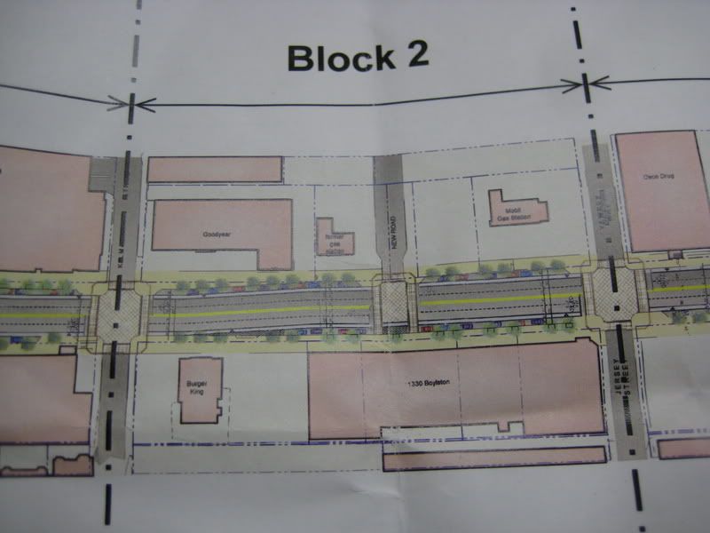
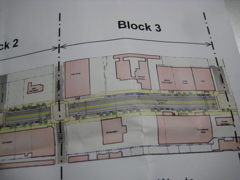
Rosenthal's development would also benefit from the street the city is seeking to build through the neighborhood. The road would connect Boylston Street to Brookline Avenue, and then run into Overland Street, which filters into the parking lots on which Rosenthal is seeking to build.
"It will be a great new connection to take pressure off Kenmore Square," he said. "It really begins to connect the dots in the area."
The road would be constructed in concert with Samuels's new development, which still must go through years of permitting and other reviews. The design of the road still needs final city approval.
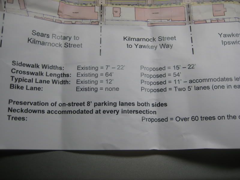
City planners said yesterday they are also seeking to revitalize the streetscape along upper Boylston by widening the sidewalks and creating shorter pedestrian crossings. Those improvements, along with the new road, would be funded through a $55 million Fenway economic stimulus bill passed by lawmakers in 2007.
The goal of the improvements is to make the streets more walkable and welcoming to new retail development. Samuels said the changes would allow the city to rebuild largely unused roads like Van Ness Street, in an area he wants to transform into a narrow shopping corridor along the walls of Fenway Park.
"It could be a great little retail street, like Newbury," Samuels said. "The idea is to create a Main Street for the neighborhood that is more walkable."
Casey Ross can be reached at cross@globe.com.
Link]/url]
Retail residential complex proposed for area between Park Drive, Yawkey Way
By Casey Ross
Globe Staff / September 19, 2008
A developer is proposing his third retail and residential complex outside Fenway Park - a project that would be aided by a new street the city wants to build to spur fresh development in the neighborhood.
The plan disclosed by Steve Samuels and city officials yesterday is the next step in transforming the gritty triangle between Park Drive and Yawkey Way, where residents and neighborhood planners have long sought to create an "urban village" in the shadows of the ballpark.
Mayor Thomas M. Menino said plans for the new quarter-mile-long street, to run parallel to Yawkey Way, would ease traffic congestion and lay the groundwork for a shopping district where Fenway sausage vendors would intermingle with high-end boutiques.
"What we want to do is have a balance between residential, retail, and some office space," Menino said. "It will be a more walkable area, a more friendly area. Now all you see is auto repair shops and sub shops. That's not the future, that's the past."
Samuels said his proposed development on Boylston Street would include ground-floor shops, a supermarket, and residential units. He said he has not settled on an exact height for the building, but he pledged to keep it within the scale of the neighborhood.
The proposal comes amid a burst of development around Fenway, much of it by Samuels and his partners. Yesterday, he celebrated the grand opening of 1330 Boylston, a $140 million complex that includes 215 residential units, shops, and offices for Fenway Community Health Center. Samuels also developed Trilogy, a $200 million project of shops and apartments at the corner of Brookline Avenue and Boylston Street.
In addition to his plans, medical group Harvard Vanguard confirmed yesterday it is seeking to develop two parcels around its offices at 133 Brookline Ave. The development could include up to 700,000 square feet of residential and office space, although the precise scope of the proposal remains uncertain.
Gene Wallace, an executive vice president for Harvard Vanguard, said the company has hired the real estate firm McCall & Almy Inc. to gauge developer interest in the property. "We feel this is the right time to assess our options," Wallace said in a statement. "We are enthused about the direction of development in the Kenmore area."
Wallace also indicated Harvard Vanguard expects to remain in its Fenway offices. It is unclear whether it would seek to expand into any new buildings constructed on the property.
Also moving forward is a proposal by developer John Rosenthal to build a $500 million project along Beacon Street. The project, which is being reviewed by city planners, would include a 23-story residential tower over the Massachusetts Turnpike, and three other retail and office buildings. The Red Sox are a minority partner in Rosenthal's One Kenmore complex. The New York Times Co., owner of the Globe, holds a 17 percent stake in the Red Sox.
Rosenthal's development would also benefit from the street the city is seeking to build through the neighborhood. The road would connect Boylston Street to Brookline Avenue, and then run into Overland Street, which filters into the parking lots on which Rosenthal is seeking to build.
"It will be a great new connection to take pressure off Kenmore Square," he said. "It really begins to connect the dots in the area."
The road would be constructed in concert with Samuels's new development, which still must go through years of permitting and other reviews. The design of the road still needs final city approval.
City planners said yesterday they are also seeking to revitalize the streetscape along upper Boylston by widening the sidewalks and creating shorter pedestrian crossings. Those improvements, along with the new road, would be funded through a $55 million Fenway economic stimulus bill passed by lawmakers in 2007.
The goal of the improvements is to make the streets more walkable and welcoming to new retail development. Samuels said the changes would allow the city to rebuild largely unused roads like Van Ness Street, in an area he wants to transform into a narrow shopping corridor along the walls of Fenway Park.
"It could be a great little retail street, like Newbury," Samuels said. "The idea is to create a Main Street for the neighborhood that is more walkable."
Casey Ross can be reached at cross@globe.com.
Link]/url]
 Out of style I guess.