Forest Hills Village | Jamaica Plain

P

pharmerdave

Guest
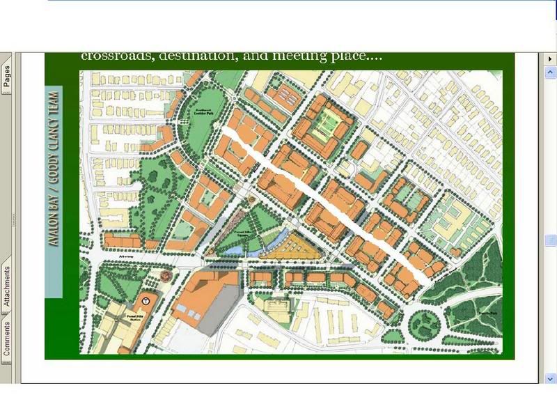
Here is a link to some proposed transit oriented developments in eastern Massachusetts. There are some scetchs of Westwood Square, Canton Town Center, downtown Lowell and my personal favorite, Forest Hills Village. The Forest Hills Village proposal includes covering up the exposed Orange Line tracks with apartments and Southwest Corridor Park as well as 2500 units of housing. The sketch-ups reveal two or three 20 story buildings. It also appears that they will bring the Arborway back to a grade level avenue.

http://www.railvolution.com/rv2005_pdfs/rv2005_312c.pdf
 
I like what I see. Where does this stand in the permitting process, or is it just some long term pipe dream?
 
This looks fantastic. It's almost like Boston is looking a little more toward what actually works in great cities (like the ones in Europe).
 
That plaza area looks beautiful indeed.
 
The style of drawing on page 14 is nearly identical to the old sketchup of Gateway Center. Even the style of development itself bears a great resemblance, though on a smaller scale. It even has that short curved roof tower on the left side. Either way, I think this looks like a great idea and is a great way to develop outside of the city. Hopefully this isn't just a pipedream and people are actually working on getting this in motion.
 
tmac9wr said:
The style of drawing on page 14 is nearly identical to the old sketchup of Gateway Center. Even the style of development itself bears a great resemblance, though on a smaller scale. It even has that short curved roof tower on the left side. Either way, I think this looks like a great idea and is a great way to develop outside of the city. Hopefully this isn't just a pipedream and people are actually working on getting this in motion.

I too, noticed the uncanny resemblance to Gateway center... Coincidence? I think not. Possibly some intern made the renderings? Probably.
 
I have a major problem with the Forest Hills plan. Instead of those mega-blocks each with a useless enclosed courtyard, there should be a street running through there lined with residences. Then you would have enough space left over to make a decent sized town common. We still have not learned how to reject the 1950s style planning.

Here's what I mean:

ForrestHills.jpg
 
I could be mistaken, but this seems to be more of a "look what we could do" type of plan, rather than something that is actually in the works. Isn't the MBTA Arborway bus garage under construction on part of that site?
 
I certainly like the idea of removing the overpass. I never understood why it was repaired rather than removed a few years ago.
 
Joe_Schmoe, those blocks as shown are no more than 300 x 400 feet, or about 120k s.f. of land. For comparison's sake, a typical Back bay block is about 200 x 600 feet (exact same square footage), and the WTC site- the quintessential megablock- is roughly 800 x 850 feet (16 acres), so I don't really think you can level that term at these ones. The days of bite-size Beacon Hill blocks is long past, so I'd say what we got here isn't so bad.

I guess some kind of alley or pedestrian walkway could be nice, but my guess is that, like the Westwood Station (well, per Dude's informing - the Islington) plan, the center will have parking, which is a necessary evil in today's world. And while it'd be nice to put it underground, that of course costs a fair deal of more money.
 
Many dense European cities (Paris, Berlin, Vienna) have used the apartment block-with-courtyard model since the 18th century; it's hardly "1950s-style planning". It's an effective way to deliver light to the interiors of those buildings, and to entice those who would otherwise flee to the suburbs for private recreation space...without detracting from streetlife/the street wall. In Barcelona, where there is fairly loose zoning for such places, there are actually little industries and services like car washes in the courtyards!

If Tom Menino really wanted to leave a legacy, he would use the lame-duck period before his retirement to ram through similar hyper-densification schemes in at least these major transit notes in the city's southern triple-decker belt, dramatically expanding the size and quality of the city's housing stock...not to mention its affordability.
 
And actually, when you think about it, the South End and Back Bay, though actually at lower densities in those cases. What would be the courtyards are those neighborhoods' alleys, gardens and back lot parking. And the alleys, at least, help keep city services like trash pickup off the main streets, where they would be unsightly and distasteful (as in New York, where blocks are nearly built solid).
 
kz1000ps said:
Joe_Schmoe, those blocks as shown are no more than 300 x 400 feet, or about 120k s.f. of land. For comparison's sake, a typical Back bay block is about 200 x 600 feet (exact same square footage), and the WTC site- the quintessential megablock- is roughly 800 x 850 feet (16 acres), so I don't really think you can level that term at these ones. The days of bite-size Beacon Hill blocks is long past, so I'd say what we got here isn't so bad.

I guess some kind of alley or pedestrian walkway could be nice, but my guess is that, like the Westwood Station (well, per Dude's informing - the Islington) plan, the center will have parking, which is a necessary evil in today's world. And while it'd be nice to put it underground, that of course costs a fair deal of more money.

Just to clarify, I was saying that one of the links from the AB westwood station page was to a completely different, pipe-dream, unnecessary redevelopment of a different part of town, not saying that westwood station is in islington, which it really isnt.

heh, maybe im not clarifying anything here...
 
There are community meetings on what should be built at Forest Hills and there is no solid plan yet.

The JP Gazzette has info on them.
 
Feature in the Homes section of today's Globe:

Question of congestion
Forest Hills proposal would add traffic, but planners see a solution

planners believe road changes can be made to ease traffic around the Forest Hills Station (above) is a transit-oriented housing and business complex is developed. (David L. Ryan / Globe Staff)

Can a development that adds scores of cars into an already congested area be "smart growth?"
more stories like this

That is the question looming over a plan to add 700 units of housing and other buildings in a tight configuration around the Forest Hills rail and bus station in Jamaica Plain.

The Forest Hills project is the largest so-called transit-oriented development yet undertaken by the MBTA in the Boston area. Such smart-growth projects are densely packed, mixed-use complexes built atop or near transit stations - whether suburban commuter rail stops or city MBTA stations - and promoted as an antidote to sprawl, congestion, and other attendant ills of the automobile age.

For city dwellers, the Forest Hills Station locale has much to recommend.

Pinched inside a dowdy old commercial district with several hip new outposts, the project would offer walk-on access to subway, bus, and train lines. The development could also fill in major missing elements of Forest Hills' commercial offerings with a grocery store, movie theater, and public plaza with a farmers market. Several gates to the Arnold Arboretum are just steps away, and Jamaica Plain center is not a far walk, either.

Yet outside its identity as a transit hub, Forest Hills is also a major chokepoint for traffic crossing the city in multiple directions, as well for commuters who drive to the station. Congestion on the two constricted main roads is a given at many times of the week. Traffic studies conducted as part of the planning process show that during the morning rush hour, more than 1,200 vehicles pass the station on Hyde Park Avenue heading toward Boston - about the same volume of traffic on Beacon Street as it approaches Kenmore Square.

Now add to that not just hundreds of new residents, but office workers at new commercial properties within the development, as well as shoppers drawn by new retail offerings, and there is a danger the Forest Hills development will make congestion worse.

"This is the most complicated aspect of this," said John Dalzell, project manager of the Forest Hills project for the Boston Redevelopment Authority, which spearheaded the planning process. The authority intends to have the development built according to "green" principles so that it wins certification from the US Green Building Council.

Not surprisingly, the city's transportation consultants have concluded that Forest Hills' traffic problems can be fixed. The city is already working on computerizing traffic signals to allow vehicles to more quickly move through intersections. The consultants estimate this alone will ease gridlock and free up capacity on the roads.

Also, the consultants, as well as Jamaica Plain residents who have participated in the planning, have come up with some "bold and brave" long-term strategies, Dalzell said. These include making Washington Street and Hyde Park Avenue one-way in opposite directions around the station. This plan would remove a lane from both roads and dedicate them to bicyclists and parking. While this would reduce the overall number of lanes, it doesn't mean more congestion. The idea is that with one-way streets, there would be three lanes of traffic traveling in one direction, providing better flow than two lanes heading in each direction...
--continued at: http://www.boston.com/realestate/news/articles/2008/06/15/question_of_congestion/?page=2

link to the article: http://www.boston.com/realestate/news/articles/2008/06/15/question_of_congestion/

*EDIT*
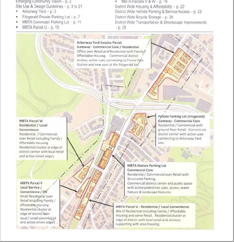
There was a map of the proposal in the paper that's not on the website, but it's just a watered-down version of the map in Briv's post.
 
From the JP Gazette:

T has a plan

By DAVID TABER June 13, 2008


Affordability concerns flood comments

FOREST HILLS?In response to community concerns about affordable housing on properties being sold for development around the Forest Hills T station, the MBTA last month unveiled a plan that gives financial incentives to developers to make housing affordable.

The plan would charge developers extra if they do not plan to build a certain number of affordable housing units. But some affordable housing advocates question whether it will work. Developers, they say, might just change their plans after the properties are sold.

Meanwhile, the Boston Redevelopment Authority (BRA) public comment period closed June 5 for Use and Design Guidelines developed as part of a community process?known as the Forest Hills Improvement Initiative (FHII)?that began in November 2006. The vast majority of comments submitted were in support of affordable housing, apparently the result of an organized letter-writing campaign.

The MBTA is planning issue an Invitation To Bid (ITB) to sell three parcels around the station outright and sell development rights to the Forest Hills station commuter parking lot.

Over 6 acres of land will be on the market under that ITB. The current draft guidelines call for 400 residential units and 64,000 square feet of retail space to be developed. Two other lots, the MBTA?s Arborway Yard and the privately owned Fitzgerald parking lot were also covered in the FHII process, but it is unclear if and when those sites will be up for development.

A draft version of the ITB was presented to the community at a May 22 meeting. The MBTA now hopes to officially issue it in late June or early July, after a June 26 FHII where the BRA will present the final version of the community guidelines.

MBTA plan
The MBTA is planning to offer the parcels with affordable housing in mind, but it has developed a unique pricing structure for the land that would require developers to pay more if they designate fewer than 50 percent of housing units affordable.

MBTA spokesperson Joe Pesaturo told the Gazette the MBTA plans to sell Parcel U?a 2.82-acre site on Hyde Park Avenue south of Ukraine Way?for $21.20 per square foot. The Use and Design Guidelines call for 150 housing units on that site. The ITB stipulates that if developers choose to make fewer than 50 percent of those units affordable ?they have to pay an additional $18.20 per square foot,? for the difference between the square footage of affordable space and the 50 percent mark, Pesaturo said.

There are similar requirements for Parcels S, V and W. Parcels V and W straddle Washington Street near parcel U and will be sold together. Parcel S is the MBTA station parking lot. The MBTA plans to lease that property with the stipulation that commuter parking be maintained.

According to the guidelines, all three parcels would contain a mix of housing and commercial space. The ITB says that if commercial space is built at the expense of affordable housing, the developer will be charges an additional $35 per square foot.

In their comments to the BRA, Bernie Doherty and David Hannon, of the Asticou-Martinwood Street Neighborhood Association, called for a similar property valuation plan for other parts of the community guidelines, including ?potential development of open space; recreational and community uses.?

Karen Caplan Doherty, also a member of the local neighborhood association, said in her comments that she is concerned the additional charge for commercial space might ?jeopardize the possibility for creative spaces and small retail.?

Affordable housing advocate Francesca Fordiani said she is ambivalent about the T?s plan. She said she is pleased the T is including some effort to promote affordable housing.

But she is concerned, she said, that there does not seem to be any mechanism for enforcement of affordability standards after the purchase-and-sale agreement is signed.

?At the [May 22] meeting I asked what would happen if the developer changes his mind. The answer was basically nothing,? she said.
Any proposed project will be subject to its own BRA-led community process, but Fordiani said she is concerned that the BRA will not be committed to affordability at that point.

The BRA controversially recently approved a proposal by Maple Hurst Builders for a much smaller mixed-use project on a formerly MBTA-owned lot on Green Street despite its failure to meet what appeared to be a specific mandate in the ITB calling for 50 percent affordability.

Affordability controversy
Affordable housing has been a hot-button issue throughout the process. Moves in recent months by the BRA to change the affordability language in the guidelines sparked outcry from some community members.

The draft guidelines?originally presented last November 2007?had recommended that that, on publicly owned land, between 15 percent and 75 percent of housing units should be sold and deed-restricted as affordable. The goal, the guidelines said, should be 50 percent affordability.
Affordable housing advocates complained that the guidelines were too vague and the 15 percent to 75 percent language was later removed. But since then it has been reinserted based on community response, said BRA senior architect John Dalzell, who has been leading the community process.
Housing affordability is tricky, Dalzell said, because the line between community and professional advocacy is sometimes blurry on the issue in JP, which is home to two active nonprofit community development corporations.

The public comments regarding the Use and Design Guidelines reflect some of that blurriness. The BRA received about 200 unique written comments according to its comment summary. But it also received about another 200 comments advocating for the removal of the 15 percent to 75 percent language in petitions, form letters and other letters that followed an obvious suggested format.

Other community members, Dalzell said, ?Are really irate that there is so much single-issue advocacy going on?There are some people who feel like some of this is about business as much as it is about housing.?

While the BRA?s job of gauging community sentiment and reflecting it in the guidelines requires that it be aware of those dynamics, ?There are board members of community development corporations who also live in the community,? he said. ?It?s not a big deal. No one should be out of the room.?

According to the Gazettes count, 34 of the unique comments the BRA received were in favor of more affordability, and 11 expressed support for giving developers more latitude. The latter, however, were almost all from street addresses in the Forest Hills area, whereas a significant portion of the former came from people who live in other sections of JP, suggesting that they may have been inspired by advocacy efforts as well.

The situation is awkward, Dalzell said, because, ?A lot of people care about affordable housing but don?t see it the same way? as the organized housing advocates.

Doherty and Hannon complained that, ?The document, as it is presently constructed is a formula for the diminution and destruction of a vibrant and growing community,? and that the FHII process had been ?hi-jacked by special interests.?

Another member of that local neighborhood group, Jack Odell, wrote that he was ?pleased to find that the plan required the development to support a mix of income levels.?

Fordiani sits on the Jamaica Plain Neighborhood Council (JPNC) and head the JPNC Housing and Development Committee. She told the Gazette that the petition and form letter campaign had been largely organized by the JPNC, a volunteer body.

?The JPNC was a big driver there,? she said.

But other organizations, including the Jamaica Plain Neighborhood Development Corporation (JPNDC), a nonprofit developer, also helped organize the campaign, she said.

Fordiani and Dalzell did offer opposite predictions for what the effect of the 50 percent guideline would accomplish.

Fordiani said that she is afraid that nonprofit developers will not be able to afford to bid on the project if the asking price in the ITB does not take the 50 percent affordability rate into account. Dalzell said other community members are concerned that the parcel would only be of interest to nonprofit developers.

Density and safety
Significant among opinions expressed by Forest Hills community members during the BRA public comment period were concerns about the density of proposed developments and public safety issues in the Forest Hills area.
A number of comments said a proposed seven-story structure at the MBTA parking lot site would be too tall. Many complained that it would block their view of the Arboretum.

Local resident Jessica Burko suggested, ?Redistribution of the uses at [the MBTA lot] onto other parcels would help allay concerns about its density.?
Doherty and Hannon echoed that comment, saying, ?The original vision proposed centering Forest Hills at the MBTA station as a core for commercial, retail and community use and having mixed use and residential development fanning out from the station.?

Caplan Doherty noted that site is in two police jurisdictions, E-13 and E-18. ?Who would be responsible for policing the leased MBTA space?? she asked.
She also said that attempts to deal with other public safety issues in a part of the FHII process aimed at generating transportation and streetscape guidelines for the area was redundant.

?The short term transportation recommendations are ones that this community suggested over five years ago.?

Those proposals include making the roadways around the station more comprehensible to motorists and pedestrians by improving signage and pavement markings.

?A full vetting of all of the public safety issues must occur prior to the MBTA ITB process moving forward,? she said.
 
If there's that much traffic maybe they should extend the Orange Line.

Oh wait, that won't happen.

I think one big failure with TODs is that they base development around transit hubs that are already highly congested. Turning Hyde Park Ave and Washington St into one-way highways is a typical highway engineer solution that will turn the area into an in hospitable highway. If there is that much traffic coming from the south then how about some transit-oriented solutions? If extending the Orange Line is too much, how about looking at opening up some more commuter rail stations in Roslindale and Hyde Park?

I'm sure I'm not the only person who has thought of this, but what I'm also sure of is that this option was probably taken off the table 'cause everyone know the T couldn't afford to build a new station. How are TODs supposed to work if the transit doesn't?
 

Back
Top