Green Line Reconfiguration

Thanks, yes, understood. But what about dipping wayyyy down to deep bore? I know I'm stretching here, but it's hard for me to accept that Essex must be impossible. I'm not just trying to be transit-line-OCD here as you call it. North station to South Station via Deep South End is ultimately very roundabout and would likely put off potential ridership.
 
Thanks, yes, understood. But what about dipping wayyyy down to deep bore? I know I'm stretching here, but it's hard for me to accept that Essex must be impossible. I'm not just trying to be transit-line-OCD here as you call it. North station to South Station via Deep South End is ultimately very roundabout and would likely put off potential ridership.

SL III was pretty hella deep, so that's really not conjecture...they were already there. It was the only way they could underpin the two track levels of Boylston without wrecking the upstairs infrastructure. And the only way they could slip far enough below the Common to slip under the burial ground without destroying it. The project ended up getting progressively deeper the more problems they found on those adjacent city blocks. Pedestrian flow at Boylston Under would've sucked because the escalators to the surface would've been pretty freaking long. Ideal transfer station configuration it was not.

Unfortunately because you only have one depth you can square-up with for those 2 blocks of Essex between Surface and Atlantic that slip under 93S and over 93N for level insertion into the Transitway, that puts an upper bound on how steep you can drop before needing to level out for the Chinatown Under platforms. SL III was damn close to the steepness limit for BRT. Given how tall some of those buildings are, the degree of difference between BRT and LRT max grades isn't going to be a game-changer for avoiding building pilings. The deepest old masonry foundations like the Masonic Lodge on the corner of Boylston/Tremont are going to be just as dicey.

The only thing LRT's got to its advantage is slightly slimmer tunnel width. That's meaningful. Not nearly meaningful enough to take a half-billion off the soaring mitigation costs, but a significantly better puncher's chance than BRT had.
 
I understand that having to pass under the Orange Line is a negative to this scheme. However remember how much more involved the Silver Line Phase 3 was. This proposal does not create a bus tunnel portal down Charles Street and does not involve passing under Boylston.

Also keep in mind the Red Line does pass under the same vintage Orange Line.
That's not a relevant comparison. Orange tunnel was 7 years old when the Red extension from Park to SS opened, not 107 years old. The mitigation risk here is just as maximal as it was with Silver. Now, you can game the overall scoring odds as better by avoiding that whole 2 block stretch of Central Subway mitigation, but don't be surprised if an FEIR upchucks a fatal blocker at Chinatown. It could've happened had SL III continued; it could happen here. The potential risk is equal at that spot, and the alignment is going to score more poorly than one that avoids all of the vintage-construction subways.

The same goes for any invasive mods to Boylston station. It's better than the SL III plan by a longshot, but it is still a very major structural modification to the 1897 station situated on a very tight corner surrounded by tall old buildings. It's going to score worse on feasibility/cost than a build that leaves the station alone. And since feasibility scoring is what KO'd the original project, Take 2 has to roll back the √- grades that put the final nails in the coffin and present a plan that maximizes the √+'s before an Alternative is allowed to proceed.


This is very different than the usual Crazy Transit Pitches-type builds where there's a project mission statement and the cleanroomed design Alternatives seek to maximize that statement. This was an unfunded mandate with an actual set design...that design failed...and now the project needs to be rescued off the trash heap. The task that real design money will be appropriated for is for troubleshooting the project properties that proved so much more unfavorable on feasibility than originally expected, and containing the risks. The mandate is going to be taking what they've learned about those low odds and finding a design that has highest possible odds of feasibility for meeting the project goals.

Not "higher than Phase III". Highest. "Higher than Phase III" isn't instructive when the mitigation bill was already being counted in billions around these same abutting structures. If the interface with old tunnels and old stations was one of the biggest sources of unbounded bloat...the alignment that avoids it is going to score tons higher than the one that significantly re-engages that mitigation. That render of the Boylston alignment is a significant re-engagement of that same mitigation...whether less overwhelmingly so or not. It starts out at pronounced project scoring disadvantage to the Alternatives that avoid that same mitigation.


It's a much more bottom line -specific Alternatives scoring this time vs. the first time around when the top line was the primary debate topic. We established the baseline for the "gross" side of the ledger long ago:

-- provide direct rapid transit link from the Transitway to downtown, relieving congestion on the Red Line and the Big 4 downtown transfer stations.
-- provide direct Orange transfer along the way.
-- provide direct Green transfer or branching.
-- general alignment favoring the gateways to Chinatown and South End neighborhoods that are in need of a load-bearing flank.

The pro/con arguments over which provides more "gross" were hashed out 15 years ago. But we still have no build. The pros/cons of Take 2 are all going to be about the "net" side of the ledge: feasibility and taming the mitigation costs, not alignment intangibles or differences in top line ridership counts for Chinatown vs. Tufts, X travel time on the clock vs. X+1 travel time.

Simply put: what is the MOST feasible route with the LEAST costly mitigation that avoids the BIGGEST mitigation triggers upending the last attempt...while meeting the baseline project goals.

The only question over 'gross' that we have today is "does it exist in any form that meets baseline goals?" or "does it not exist in any form whatsoever?" And that's a largely settled argument; we long ago established that Door #2 isn't acceptable at all for the long-term. So now debate the "net" side of the ledger. If costs for mitigation are far and away the biggest threats to net value, then the fix is all about taming those costs by avoiding that mitigation.

It doesn't get any simpler than that. There's more than one alignment Alternative that could score tops or near-top of the list, but all of the ones that do score high will have one shared trait: they avoid the most severe mitigation triggers, and avoid the highest total number of mitigation triggers. Not avoid some of them...avoid the most.

Of the 2,000ft from South Station to Boylston the first 500ft would be the same on a Hudson Street or an Essex Street route. The difference with the Essex Street route is there is another 1,500 ft to dig, while the Hudson Street route has 3,000 ft to dig just to get to the Tremont street tunnel. Then there is another 1,000ft of Tremont Street tunnel which needs to be refurbished, power run through and tracks laid.

That is a lot of additional tunnel to pay for. My gut tells me it would be more expensive and may have more unknowns to discover as it is double the distance of new tunnel.
You'd be wrong. Raw tunneling length isn't what drove up SL III's cost. The portal alternatives were all pretty similar in total length...but the cost ended up more than doubling over a 5-year span of design tweaks. Underpinning structures was the source of all that bloat. Yes...lopping off the west end of the BRT plan saves a lot of steel and concrete. But tunneling feet is not why the SL III plan failed. It failed because of structural impacts. In fact, the most direct alignment with the fewest tunneling feet ended up the slowest on the SL III plan because of the compromises forced by all that mitigation.

It's not addressing the right problem to score (X - Y ft. tunnel) < X ft. tunnel as a cost saver. Increments of generic tunneling feet and utilities behave more or less like fixed costs; mitigation impacts behave like exponential costs. (A - B structural impacts) < A structural impacts is the only cost saver that matters when scoring Alternatives. An alignment that structurally engages the oldest tunnels and Boylston station is going to have a poorer scoring than one that doesn't. It doesn't avoid nearly as many exponential cost stressors.
 
North station to South Station via Deep South End is ultimately very roundabout and would likely put off potential ridership.

I don't buy this. Riders don't have the slightest idea how physically long transit routes are, because transit route maps aren't designed to show that. As long as the route is fast and functional potential ridership does not care about the route. The Bay Village/Marginal/Hudson route sure as hell looks roundabout... but it would be fast. The long, station-less stretch between Tufts Med Ctr and South Station would fly.


Of the 2,000ft from South Station to Boylston the first 500ft would be the same on a Hudson Street or an Essex Street route. The difference with the Essex Street route is there is another 1,500 ft to dig, while the Hudson Street route has 3,000 ft to dig just to get to the Tremont street tunnel. Then there is another 1,000ft of Tremont Street tunnel which needs to be refurbished, power run through and tracks laid.

That is a lot of additional tunnel to pay for. My gut tells me it would be more expensive and may have more unknowns to discover as it is double the distance of new tunnel. [/quote]


[QUOTE="F-Line to Dudley, post: 254212, member: 2007"]

You'd be wrong. Raw tunneling length isn't what drove up SL III's cost. The portal alternatives were all pretty similar in total length...but the cost ended up more than doubling over a 5-year span of design tweaks. Underpinning structures was the source of all that bloat. Yes...lopping off the west end of the BRT plan saves a lot of steel and concrete. But tunneling feet is not why the SL III plan failed. It failed because of structural impacts. In fact, the most direct alignment with the fewest tunneling feet ended up the [I]slowest [/I]on the SL III plan because of the compromises forced by all that mitigation.

It's not addressing the right problem to score [I](X - Y ft. tunnel) < X ft. tunnel[/I] as a cost saver. Increments of generic tunneling feet and utilities behave more or less like fixed costs; mitigation impacts behave like exponential costs. [I](A - B structural impacts) < A structural impacts[/I] is the only cost saver that matters when scoring Alternatives. An alignment that structurally engages the oldest tunnels and Boylston station is going to have a poorer scoring than one that doesn't. It doesn't avoid nearly as many exponential cost stressors.[/QUOTE]

Essentially, here we are at the impasse again. Same impasse that's always arrived at. Everyone agrees that multiple alternatives must be studied, including an Essex Routing. We can all lay out the pros/cons of different routings and which routings are more likely to survive the study phase, or which routings will encounter fatal physical blockers.

As it currently stands, with the information we have, the "roundabout" route seems to fulfill the project requirements with the least potential engineering blockers. Of course one can appeal to the unknown and say "well who KNOWS what would be encountered on the 3000ft stretch of new tunneling that might be a blocker." Sure, but that's not an arguable point. It's a claim that appeals to the unknown. If we want to be able to move forward, and not keep arguing in circles again in a few months' time, we have to make these projects part of the broader transit conversation in the city and state.
 
Last edited:
+1 I totally agree on all the points you brought up busses. On a map the South Bay route could actually be made to appear relatively direct for example:

IlIMlHR.png

The black line is geographically accurate
The dark green is a line based on the current MBTA map
The two lighter green lines are Map options

Link to the Google Map: https://www.google.com/maps/d/edit?mid=z-P0elakuhEs.kFjyL1jakeC8&usp=sharing
 
Small quibble though, if you have an Ink Block infill stop then the detour becomes much more obvious.

Anyway, Busses is right though.
 
Maybe after making that map above I checked the MBTA map and the orange line station spacing is wider than I thought so using the current map the route would look more like this:

23rOvbT.png


Current MBTA map:

subway-spider.jpg
 
Small quibble though, if you have an Ink Block infill stop then the detour becomes much more obvious.

Anyway, Busses is right though.

I think it would be criminal to make that long of a run without a station at Marginal.
 
Late to this party. The large issue with going Tremont > Essex is that it doesn't hit the Back Bay without a transfer. Ideally you'd want trains from the north and the west to get to the Transitway.
 
I think it would be criminal to make that long of a run without a station at Marginal.

Yeah. 100 ft. x 300 ft. parcel that's. . .

  • a full city block clear of the Orange Line
  • tangent stretch of track
  • under an urban renewal zone
  • next to a school that's out-of-session for 2 months during the year for scheduling the most invasive construction impacts
  • at the crossroads of the biggest thoroughfare in the neighborhood
  • across the Pike from one of the big new neighborhoodlet developments
  • sitting across the street from one of the air rights parcels MassDOT's been trying to unload for 40 years
  • ...air rights that, if infilled west to Back Bay could extend the indoor Copley Place concourse all the way to this stop
  • ...air rights that can public-private subsidize the construction/furnishing of the actual station
  • gets closest to plugging the midpoint catchment between Tufts and SS (maybe a Kneeland St. subway with stop on the Harrison-Tyler block would do better relative to SS, but it would be only 800 ft. from the nearest Tufts entrance and would pass up any catchment on the Ink Block side of the Pike.

That's awfully juicy. Juicy enough to hollow out the station shell to furnish later for a later infill if you're short on cash for Day 1 service.
 
Late to this party. The large issue with going Tremont > Essex is that it doesn't hit the Back Bay without a transfer. Ideally you'd want trains from the north and the west to get to the Transitway.

Phase III didn't allow for traffic from the west to get in, either. It was SS-Chinatown-Boylston, and then the portal out to Washington St. The tunnel, because of the headway-infringing speeds on the BRT'd Essex alignment, was going to be operating too close to capacity from Day 1 to start adding other full-service routes out the South End portal. The 'solve' for Seaport-Back Bay mobility was the addition of Orange and Green transfers +1 stops removed from Park & DTX. That load-spreading is what would keep subway dwells at the Big 4 downtown transfers from collapsing on themselves and creating a mobility wall between downtown and the Seaport.

The new build's goals are fishing Phase III out of the trash and retooling it so it meets the same basic project goals with a build that's feasible this time. They can't afford to be throwing it open to new mission creep, because the fix is for the bottom line feasibility, not the top line feasibility. They already established that the load-spreading away from Park/DTX/SS transfers accomplished the goals. That's the unfunded mandate...not a one-seat to Back Bay Station.


If you want a one-seat to Back Bay, you can build it for future compatibility with a Copley Jct.-replacement station. Future...not Day 1, because it's not in the scope for this project's Day 1. 4-tracking Tufts station and leaving a tunnel notch at the corner of Tremont/Marginal for a bi-directional junction can do that. It can also be done on an Essex LRT alignment, but only if you radically reconfigure Boylston station to even more invasive degree than Upstruk's render and count on a relocated Copley Jct. hooking into the old Central Subway Boylston St. incline. That's going to score very poorly on structural impacts, however...so probability is extremely low that it'll be a preferred Alternative.

Any which way, it's out-of-scope for Day 1 because the project doesn't get funded at all if the focus wavers from salvaging Phase III's goals to adding new mission creep. You have to present a plan that'll get the FTA back on-board with federal funding commitments. They pulled out because of too-low feasibility scoring. The only way back in is by maximizing the feasibility scoring. Adding mission creep doesn't accomplish that.


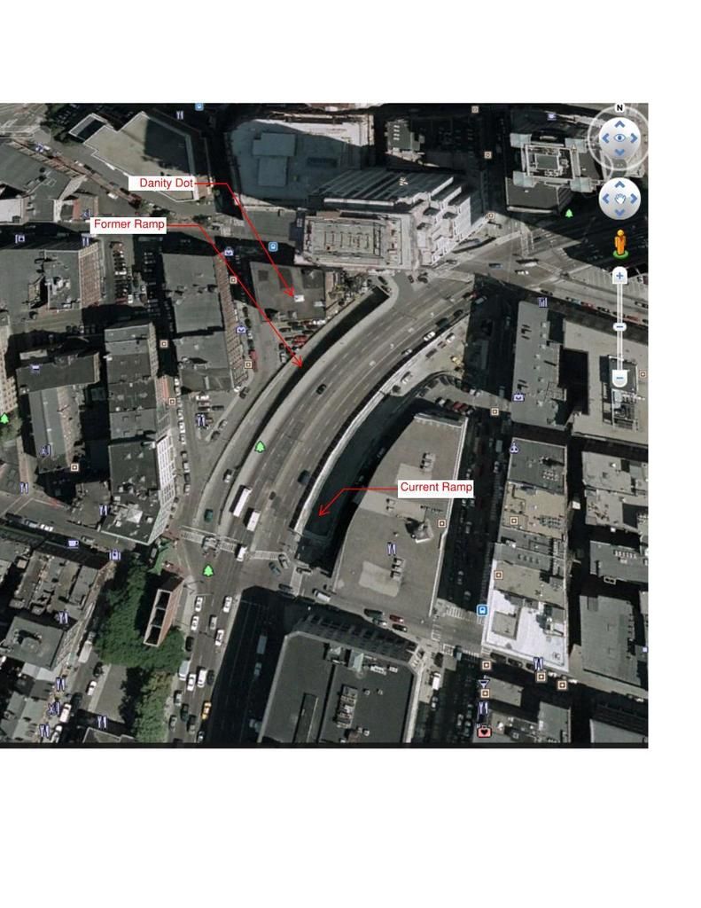
During Big dig aerial which shows filled I-93 Ramp. This is the current location of the Chinatown park and potential location for Hudson Street subway.


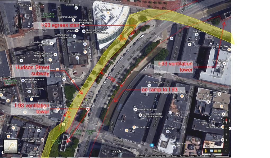
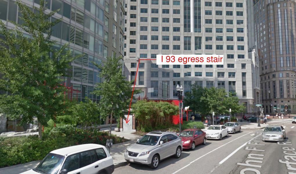
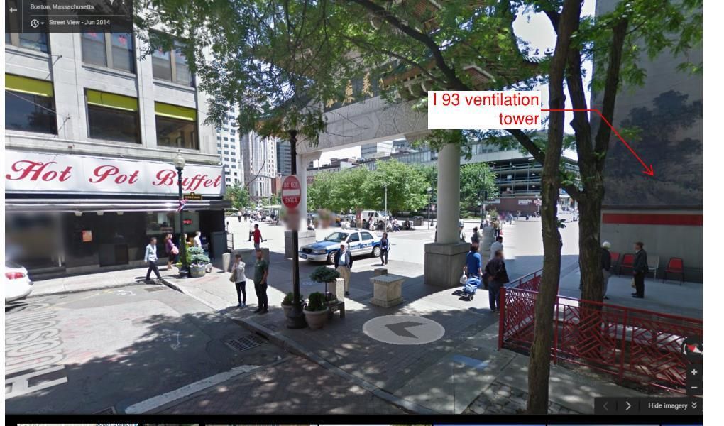
Above is a map which show obstacles to avoid for a new tunnel. Please note the I-93 Egress stair which is about 25 ft from the Radian building and the I 93 ventilation tower at Beach Street.


I 93 Egress Stair


Ventilation Tower at Beach Street


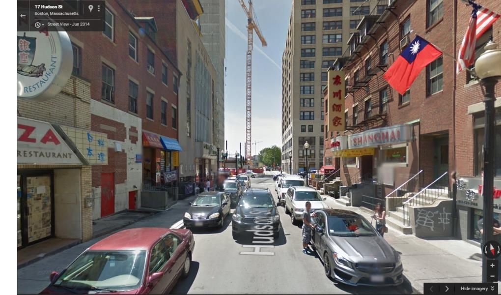
Hudson Street between Beach and Kneeland Streets
 
Essentially, here we are at the impasse again. Same impasse that's always arrived at. Everyone agrees that multiple alternatives must be studied, including an Essex Routing. We can all lay out the pros/cons of different routings and which routings are more likely to survive the study phase, or which routings will encounter fatal physical blockers.

As it currently stands, with the information we have, the "roundabout" route seems to fulfill the project requirements with the least potential engineering blockers. Of course one can appeal to the unknown and say "well who KNOWS what would be encountered on the 3000ft stretch of new tunneling that might be a blocker." Sure, but that's not an arguable point. It's a claim that appeals to the unknown. If we want to be able to move forward, and not keep arguing in circles again in a few months' time, we have to make these projects part of the broader transit conversation in the city and state.
No, it's not the same impasse. There's a full accounting of exactly where and how Phase III came unglued, and it was on the feasbility scoring of their alignments. Plus an indirect influence of their choice of BRT mode forcing the alignments that got poor scoring. There's a full accounting of what the triggering event was for the project's end: the FTA slapping it with a not-recommended rating when the feasibility scoring dipped too low, ending any chance of federal funding. There's full accounting of exactly where the feasibility took the biggest hits: structural impacts around old transportation structures primarily, and structural impacts around too many old building foundations secondarily.

Restarting it does not mean we're at ground zero and everything has been reset to unknown-unknowns. It means the starting point is where Phase III left off, and the task is rolling back those feasibility demerits to hit the same top line project goals at far better bottom line. That's the fundamental difference between it being a Crazy Transit Pitches-type cartographer's spit-take where anything goes, and a real unfunded-mandate project that's getting a second take. The project is about making design changes that correct the poor scoring, not starting over with a blank sheet of paper.


Change #1 that corrects the scoring is switch of BRT to LRT, because that is the only way to tame the worst of the Central Subway structural impacts and the Transitway is already future-proofed for this. Now you have to score the routing Alternatives that eliminate the most structural impacts, and thus the most sources of exponential cost bloat. The bottom-line scoring informs the probabilities that a given routing will work, and then you pick your winner and your backup(s) and put them through the FEIR. That's not an appeal to the unknown; it's an appeal to quantifiable probability of success.

Phase III's problem is that it didn't appeal to quantifiable probability of success...it appealed to political choice of the BRT mode and BRT branding. That's what introduced the structurally-impacting west portal and stipulation that it be shotgun-married to the El-replacement Washington St. line, even though that is not a service pattern with established demand. That's what introduced the structurally-impacting Boston Common loop and extra block of Central Subway impacts. And that's what introduced the building impacts on Essex St. because verboten destruction of the Tremont tunnel prevented scoring of any South End alternatives through urban renewal land.


So if Project Change #1 is BRT to LRT, that is the decision that opens up a head-to-head Alternatives analysis of Essex vs. Marginal that did not occur on the original plan. Recall that in the early-70's when all the big transit studies were done in the wake of the SW Expressway cancellation they did study Washington St. light rail via the Tremont Tunnel to Marginal St., slipping under the OL South Cove tunnel, portaling-up on the Pike-facing sidewalk of Marginal east of there, and turning onto Washington. I linked to the diagram of it sometime last year from an online-archived photocopy of the study, but can't find it on board search. Half the South End alignment was previously scored as a known-known. It was not studied to the Supplemental DEIS -level that the Essex BRT alignment was, but it was studied with hard data and is most definitely not an appeal to the unknown.

Since the Big Dig cleanroomed all of the area around the Transitway insertion and gave the Surface-Atlantic block of Essex a clean bill of health, we also have hard data confirming that feasibility (and the poorer scoring of the C/AT-cleanroomed South Bay spaghetti ramps as a viable Alternative).

Therefore, the only unstudied unknown with the South End alignment is how you do the tunneling segment between Marginal and Essex @ Surface...or, between the Tremont Tunnel and Essex @ Surface. Not Essex vs. South End, but intra- South End. It doesn't necessarily have to be Marginal. Stuart/Kneeland is guaranteed to be a studied Alternative too. Its only potential structural impact scoring demerits may be busting out of the Tremont tunnel at a sharp angle, and turning north at a sharp angle around Hudson. But if a DEIS ends up scoring those two single-point impacts as benign...Kneeland looks pretty solid because its width sidesteps so many building impacts. Oak could also be a #3 South End alternative, but highly doubt the narrowness is going to score well vs. Kneeland or Marginal.

I'd assign a somewhat higher probability to Marginal by virtue of recycling the previous study, having no Tremont tunnel impacts, and being tangent when it has to thread around Hudson. But I'll freely admit that's conjecture. Marginal vs. Kneeland are unlikely to have divergently different feasibility scores, so either one is likely to check out feasible enough to salvage the project. The only unknown is which is going to score better than the other; that's what DEIS's are for.


We aren't playing with full unknowns for Essex vs. South End. Essex has to be a study Alternative because the Phase III SDEIS has more granular detail there than the older South End study. It's S.O.P. to use all available prior study info, and given the salvage nature of the project a necessary fallback position to consider on a project this vulnerable to being upended by fatal blockers. However, we DO know enough about Essex vs. general South End routing scores, because we know exactly which exponential-cost structural impacts killed Phase III. Essex touches more of those structural impacts than any alignment that leaves Boylston station alone, leaves the old buildings on the first block of Tremont south of Boylston alone, and doesn't touch anything until (at earliest) the Stuart corner. Those scores are known-known. The only unknowns that could bring Essex back in favor as the fallback is if any of the wrap-around alignments through South End pile up enough fatal blockers to roll back the considerable scoring advantage of Tremont-exiting-Boylston vs. Essex-exiting-Boylston.

The unknowns for potential demerits are self-contained there on the cross streets of the South End. It is very well-known today which mainline alignment gets off to the races out of Boylston with the biggest scoring lead.


Hudson Street between Beach and Kneeland Streets


↑This↑ is the scariest one. If you can do it between this set of vintage buildings, you can do it between every other space on the rest of those photos because the tale of the tape measure puts the other ones wider. ↑That↑ is the torture test for the South End alignments.


Of course, ↓this↓ is upper Essex, where they wanted to build the wider BRT tunnel:
2rpw781.jpg


Count up the old building foundations head-to-head, then assign probabilties.
 
F-Line, I understand there have been a lot of studies that have been done that can be built upon simply by re-approaching the issue (i.e. connect the South Boston Transitway to the rest of the T system) and simply changing the perspective so that the focus is on doing it by LRT instead of forcing yourself to figure out how to get it done with BRT. However, I don't think that is what Busses is saying. I believe he is raising the point that basically asks the question of "How do you get this on the public's radar screen?"

The Seaport is booming and there have been a lot of focus on its transit needs in the press. Yet despite these aforementioned factors, the idea of connecting the Transitway to the rest of system by allowing for an LRT connection is not discussed. I can't find it in the press, I don't see it discussed in planning documents (and I've read a lot of planning docs); I only see it discussed here.

That I believe is Busses' point.

This proposal is extraordinarily compelling. Moreover, it's a veritable homerun in terms of fixing many of the T's legacy problem if you also include the Washington Street silver line conversion and also the connection to Back Bay which includes the switching of the E line over to undo the Copley Junction debacle. So why is it never brought up? There are so many stakeholders and power brokers that stand to benefit why aren't they advocating for this? Why is this on no one's radar?

If the broader public were to even know this is a very viable possibility I think it would quickly become a big part of the dialogue. I think Busses feels the same way.

So F-Line, here's a specific question in the event you might be specifically knowledgeable on this subject: How much would a basic feasibility study cost that outlined this LRT to the South Boston Transitway proposal utilizing many of the other studies that have been prepared beforehand? In other words, how much in general would it cost to commission a consultant/engineering firm to write a report on this matter?

The reason I ask is because I think going wide with a Feasibility Study in hand is the only way to get this into the public discourse because unfortunately the T is not about to start studying this on their own volition and it only goes from being an idea to a plan once a shiny report is prepared that politicians and property developers can wave around to support the point. So the question is, how to we get from here to there?
 
http://www.abettercity.org/docs%20starting%206.30.2015/2015.08.17%20SB%20Revised%20Progress%20Report.pdf

http://www.abettercity.org/landdev/southboston.html

A Better City did do a super general study of Seaport transportation. It makes mention in the Agenda going Forward section to Evaluate prior plans and engineering studies for the Silver Line connections to the Orange and Green Lines.

I believe this is the most that has been publicly discussed.

Yeah, I've seen those too. It's a shame that zero public or private institutions in metro Boston are failing to put any deeper thought into transportation solutions. Given how long the lag-time is from idea to implementation, it's really a travesty that this website has the most conversation (in rather realist terms) on these matters.
 
I don't know what the going rate for studies is, because it all depends on what the scope of it is and how disciplined they are at enforcing scope. If they're disciplined here about not introducing mission creep, then the SL III scoping for the Surface-Atlantic block can be recycled stet. The Tremont tunnel is well-documented enough that the only thing to study there is interior rehab and re-equipping it. The Green Line would have to be studied for traffic management, which would require recycling the engineering for the Park St. inbound inner track thru-service project, canceled because the cost of relocating support pegs and utility boxes priced higher than expected. The 1970's studies about the South End alignment and underpinning the Orange tunnel, and 1960's-70's urban renewal documentation of the utility layouts on those new-construction blocks, can fill in a bunch of puzzle pieces. It would still need the full DEIS treatment and funding for a full DEIS, but we know more about what lurks there than we know about that last-ditch Charles South portal alignment from Phase III.


The one thing to remember for setting project scope boundaries is:
SL Phase III DID have a recommended rating for FTA funding at one point.
This is crucial. In fact, there is nothing more crucial to its chances than this fact. The feds gave it a tentative funding commitment. The rating was changed to not-recommended because of the structural blockers. Therefore you want to present them with a DEIS that specifically addresses the points of failure that changed their previous recommended rating, such that there's an ironclad case to be made for "fixing the glitch". You mentioned in the previous discussion about the NSRL how Denver FasTraks is getting showered with federal money because they did such an outstanding job ensuring good faith cost control within project scope. Such that the feds were compelled by good faith in return to keep shoveling the money.

Well, that is exactly what we're shooting for here. Frame it as a project re-start with the same mission statement, but with a point-by-point rebuttal in the design changes to each failure point that the feds cited when they changed their rating to not-recommended. That requires a "concession" (*snerk*) of change of mode to LRT, requires a concession dropping the Dudley-Seaport one-seat in favor of a two-seater transfer. And if Washington St. LRT isn't in the immediate plans...yes, that means compensation by implementing free tap-on/tap-off transfers between surface Silver and underground subway (something we probably should've had by now). If you're feeling a little bold about advocating for the Ink Block infill, make sure that reasoning has a well-articulated Washington compensation angle so it doesn't look like mission creep (it's reasonable; Ink Block ridership was one of the justifications for the conjoined BRT route). State the very high probability of a new alignment and need for swapping-out the Orange transfer station from underpinned old Chinatown to offset newer Tufts. But leave the project scope alone to maintain the chain of continuity. The feds will have a very compelling cost control case in front of them for bringing back the recommended rating and fast-tracking their funding contribution.

It seems like meaningless semantics, but it's very real and the only way this will work. If the project scope changes, then it goes to the back of the fed review line in competition with many, many transit projects in many, many cities. With less chance of gaining favor because it'll be re-competing with the Denvers of the world who've proven themselves time and again at cost control. Massachusetts can't afford to swallow the whole $1.5-2B on its own. Nor can it waste another 20 years bogged down in studies before the congestion stymies the Seaport's economic growth and ushers in a period of stagnation.

So set aside the scope change wishlist like "oh, this time we have to have a one-seat to Back Bay or Kenmore". That turns it into an entirely different project and sends us to the back of the fed review line. Continuity of scope is the only prayer this has of getting back off the mat. Want westbound expansion? Put a bellmouth notch in the wall and compartmentalize it for a different build entirely, and don't cannibalize that 4 tracks of flyover grade separation in the Tremont tunnel. That's exactly how the Transitway compartmentalized itself from Phase III, and note well: the compartmentalized Transitway did get built, and wasn't KO'd by being joined at the hip with Phase III. Deal with the stuff outside of scope later. The add-ons will either get built when they get built, or that bellmouth notch becomes a trivia answer like the notch in the Central Subway wall for the unbuilt Post Office Sq. subway.

And this is also why I keep harping on the feasibility scoring for these alignments, and keep stressing that this is not a Crazy Transit Pitches cartography thinkpiece. It's not enough to seek a rating reversal with an an alignment that's more feasible than Phase III...but still incurs exponential cost risk by engaging the same structural mitigation. The be-all/end-all for project starts is presenting the most feasible alignment that neutralizes the most failure points and biggest failure points from the rejected plan. It doesn't matter if you can structurally renovate Boylston a lot less invasively if there's another alignment Alternative that meets the project goals without touching Boylston at all. South End has a born advantage there. As mentioned before, the only thing that's really going to put Essex back on top is if the un-studied cross streets in the South End upchuck so many fatal blockers it totally squanders the huge scoring advantage South End starts with on trek out of Boylston. We're way past the point of debating cartography. This is all about salvaging the recommended rating on a project of pre-existing scope. That only gets done with a "best" feasibility score, not a "better" or "splits the difference" score.
 
Does anyone have ideas for how to get this into the general consciousness of the citizens and planning departments of Boston as well as Massachusetts?

At this point it is still an interesting hypothetical dilemma but it also addresses a real need for transit and could lead to better rail operations eventually as well as more options for relieving Central Subway congestion so how do we move this out of the echo chamber here and into the public dialogue?
 

Back
Top