Ah oops, I see. In fact, I’m actually suggesting that Criss Cross would either loop some trains at Park, or would add a northbound crossover north of the station, or both. (This detail is tucked subtly into the track diagrams above, but I should have mentioned it more clearly. )I think the main point here that I didn't realize beforehand is: You're implicitly assuming some Huntington trains would regularly turn at Park St inner loop under Criss-Cross. Now with this detail, I'm fully onboard, and I do agree that Criss-Cross can still be a capacity boost even for Huntington.
Yeah. And it’s interesting to note that I think this is actually how it’s being used today — the Inner Loop is just being used for RADs. I dunno what to say about that.Previously, my mental image was that Criss-Cross would leave the Park St loop unused (except for run-as-directed trips), but Tripld uses it to terminate B and C trains. In that scenario, we're essentially comparing M=40 for Tripod to M=30 for Criss-Cross, and it does become a notable negative for Huntington.
Thanks for finding those numbers! Yes, I think this is a fair point. For the moment, my thinking remains that the best path to high frequencies is a simple network topology, but obviously my thinking on that has evolved over the years, so perhaps I’ll be convinced to go the other way again!So there's still a notable difference between LRT and HRT for an apples-to-apples comparison.
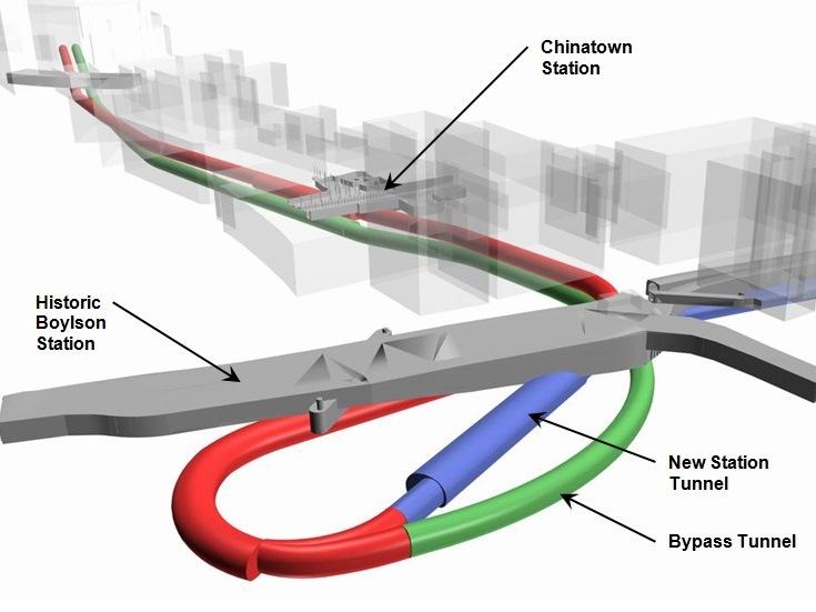
Sorry, this was a thought I had toward the end of writing the novel (lol) so I didn’t explain it very clearly. Using the Criss Cross designations, I’m suggesting:I don't see what you meant by "keeping a version of the E in place"? Under Criss-Cross, the bottleneck isn't anywhere close to Huntington tracks itself: it's on the Tremont St subway, either at Park St or Government Center.
- Quad tracks between Symphony and Back Bay/Copley: one set (Green) goes to Park St, the other (Gold) to the Seaport
- At Symphony, Green tracks continue underground in a new subway
- Gold tracks rise to surface through existing (or slightly reworked) portal at Northeastern, and run in the existing (or slightly reworked) reservation at least until Brigham Circle
- The “Fenway Branch”, which on my diagrams above is used to serve Heath St + Hyde Sq, would instead loop at Kenmore (and potentially be truncated at Brookline Village as a shuttle, or something, with the Gold Line continuing at surface level to Heath — that’s what I meant by “keep today’s E Line intact”)
- Fenway Branch Gold Line trains would therefore be swapped out for Huntington Surface trains
- Provides a 1SR between Huntington and the Seaport, and provides additional capacity along Huntington itself
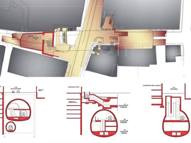
Oh that’s a fair point. I went back and looked at the diagrams, and sure enough they suggest crossing just south of the station. You need to underpin the tunnels to the Pleasant Street portal, but that’s probably easier.maybe? It wouldn't need to dive under Boylston station though so maybe not, I'm not sure. I'm also not sure if the plan was designed with the Washington St Subway in mind or not.
More to come later whenever I have time to read a novel lol.
That being said, I think if you did that, it would be much harder to use all four tracks at Boylston, which is hardly fatal, but still a drawback.