Green Line Reconfiguration

I'm very much of the opinion that, once everyone looks into it, trying to construct the Urban Ring as its own grade separated right of way for LRT isn't worth the costs. The boomerang is the most feasible solution in a very constrained environment that really doesn't allow for any alternatives that aren't super megaprojects. Hovever, I just don't know if it is necessary in a world where the core system's capacity has been enhanced significantly. Just increasing the net of transit around the urban core and untangling some to the system knots will provide a lot of the mobility the Urban Ring attempts to address. Upgrading the existing circumferential bus routes (like the 66 and the 1) will likely provide the rest.

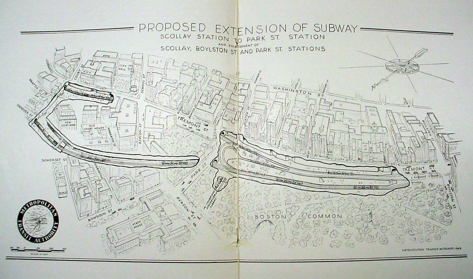
That's why I think the Green Line Solution as we've discussed here (i.e. E to Tremont Tunnel via short tunnel through Back Bay next to Mass Turnpike, Restore F-line to Dudley via reactivated Tremont Tunnel and connect the South Boston Transitway to the green line with an around the horn alignment) is much more important. Not only does it alleviate some of the major system constraints (i.e. eliminates the Copley junction; reduces the number of lines running into constrained part of Central Subway), it brings much needed mobility to important Boston neighborhoods (i.e. Dudley Square and the Seaport) and sets the stage for all sorts of other necessary system expansions (e.g. green line to Needham, Arborway restoration, Green line branch to Harvard via Allston, etc.) all in one build. I've more or less convinced myself that this is the best expansion concept talked about on AB that is not more widely known.

However, there is one part I would be interested in hearing other people's takes on. That is, what are other people's thoughts on extending the green line past Dudley all the way down to Mattapan Square along Blue Hill Avenue? I know that this has been talked about a little before but I mostly want to know:

1. How would one do it and how feasible would the different alternatives be? and
2. Why or why not this is a worthwhile endeavor?

I can think of some of the justifications for not building past Dudley but I'd like to examine the matter more before I conclude that building all the way to Mattapan is just not achievable despite all the good that it would probably do.
 
Blue Hill Ave:

Basically it's too far. Grove Hall is about the 2/3 distance from Dudley Sq as Forest Hills is and the whole reason the Orange Line was built the way it was (the elevated) was to sop up feeder trolley routes through Roxbury and Dorchester. Even 100 years ago it was a long slog from Blue Hill Ave to downtown which is why there was such an elaborate trolley-elevated transfer station built.

If things had somehow worked out differently the Orange Line could have been extended from Dudley to Grove Hall instead with a high speed trolley operating in the median of Blue Hill Ave. But no.

Also keep in mind that when we are talking about Blue Hill Ave what we really mean is Warren St to Blue Hill Ave and beyond. Warren St is the issue. It's only wide enough until MLK Blvd to have streetcars. The way that the Washington Park area of Roxbury was urban renewed involved diverting the auto traffic around the neighborhood via Seaver St and Columbus Ave. While certainly a good plan for traffic and neighborhood preservation it unfortunately didn't leave any ROW for transit.
The Blue Hill Ave corridor is actually not the best place for a high capacity rapid transit line. From Grove Hall south to Mattapan the entire west side of the avenue is flanked by park land, cemeteries, and institutions. This means that the vast majority of riders are coming from the east of the avenue and east of the avenue is the Fairmont Line.

An early plan for the Red Line was a branch down the Fairmont Line looping back to Ashmont. This would have provided much more relief than an Orange Line extension as it runs through the residential areas, not around it (like Blue Hill Ave does).

It's been stated here before but a streetcar line from Mattapan to Park St wouldn't be workable in terms of time and operations. If it was a grade separated light rail then sure but the only way to do that here is a tunnel and the costs were too prohibitive for that even 100 years ago.

Blue Hill Ave needs a couple things:
- BRT... or maybe a politician to come to the community about installing BRT before they try to build it before hand (really, NIMBYs, really?)
- rapid transit like headways on the Fairmont Line
- Green Line to Dudley.

Other than that there isn't much you can do that is reasonably affordable.

Think of how long the B line is, within it's own median, and then think about a streetcar line that is twice that, running in mixed traffic for most of the route. It's not pretty.
 
What van said.

Flank BHA by bringing the Green Line at Dudley and extend the Red Line to Mattapan. That gives riders of the 28 easy rail connections at both ends of the route (plus Indigo in Mattapan as well). No need to bring LRV all the way down BHA.
 
Part of the reason you don't need more new rail transit in Dorchester is there isn't anything south of Dorchester with the density to support transit. Even upgrading the Mattapan HSL to full Red Line isn't really that important. The Blue Hills stop any suburban sprawl dead in their tracks so you are forced to go around them; commuter rail through Hyde Park and Red Line/CR through Quincy.

Roxbury and Dorchester don't need better through service, they need better internal transit. Upgrading what is already there will have a much higher return on the dollar than building something new.

Roxbury and Dorchester can support the new middle income developments that this city so desperately needs. But part of that new development means a balance between cars and buses. The Indigo Line could handle the increased development IF it truly acts like a rapid transit line. BRT lanes will speed up commutes. But there will be more car traffic and this is the issue with new development that will hold Rox and Dot back from really exploding with new buildings.

It's a gray zone here and in an area that is very susceptible to the downsides of gentrification. Look at the reaction that killed the 28X. People with the least means have to fight for everything they have so when we propose making a faster bus line they see it as taking away their stops. Whatever does get built will have to do so with the blessing of the community. The bones of the infrastructure there are solid and we need to build on them. But spending billions to build a subway or light rail that will most likely funnel the South End gentrification into the heart of Roxbury and Dorchester is a non starter from every angle.
 
You're gonna have a hell of a time building that with minimal surface disruption, unless you're implying that that's somehow deep bored.

The Pike's at surface level and will bear 85~90% of the surface disruption that would be required to cut and cover. The rest of the surface disruption is confined to the parking lot attached to Yawkey Station. It's not like I'm suggesting we blow up parts of Kenmore, or new tall buildings constructed by BU, or neighborhood streets or neighborhood homes.

On the list of problems with what I've drawn in that map I'm frankly struggling to rate surface disruption as anywhere in the top 10.

That having been said, I'm not going to sit here and tell you it's a perfect proposal. I'm not even going to suggest it's a good proposal. I'm going to say it has some non-trivial amount of merit, it's likely feasible to build in the real world, it's almost certainly better than the Kenmore Loop, and as far as bad options go I'm comfortable calling this the best option among a whole bunch of stinkers.

That doesn't mean I'm pushing for this to go to the top of the list. In all honesty, I'd be shocked if any through running from Cambridge to Longwood ever gets built. If not this (and let's be real, it's likely not this), then I'd say the only good option is to run GJ/Ring trains back into the Central Subway and out the railstituted Seaport bus tunnel.
 
As has been said before, the scheduling problem goes away if you do the full build, which obviously costs a lot more but still isnt at all unreasonable and probably would solve a majority of the urban core's woes if done in entirety:
- Grand Jctn UR (and hopping onto the D, then E), the Seaport Connection, the new E extension along the pike to the Seaport Line, then you wind up with 3 parallel trunks to absorb the scheduling...
 
Future_MBTA_System_Map_Olympics_Version.jpg


Just need a few more billion dollars and we can start. I miss Boston.
 
My staunch opposition is twofold.

First, as you said, the scheduling and operational deficiencies might just make this thing a non-starter no matter what you do.

Second, the same curve geometry that goes into a tight loop around Kenmore is probably about equal to the curve geometry that goes into any other tight turn option which might bypass Kenmore. F-Line mentioned that coming in on the Pike approach would likely be too tight of a turn but I remain unconvinced of that in light of how tight a turn you're going to need to take around any loop track.

This is a rough draft that I'll continue work on later today. It's definitely a tight turn, but I believe it's only as tight of a turn as a loop track would be - the real killer might be adding the station platforms to create a mega-transfer between C/D/Ring/Main Line services. Otherwise, I think it's dollar for dollar the best out of what is really a bunch of bad options, and doing it this way means most of the impact zone is parking lots that might not get developed for quite some time thanks to how lucrative a business parking for Sox games is.

The difference is that Fenway Center (either yet another rehash of the current proposal or some future proposal) is going to eat the entire area that turn sits on and drive down some deep building pilings that make a moot point of even a deeper set of tunneling.

Fenway-Center-Full-Build-NPC-with-B2-Residential.jpg


-- The Maitland St./Beacon St. parking lot and the Yawkey Way/Brookline Ave. corner parking lots are under the control of other developers independent of the Fenway Center parcels. Something tall likewise can and will get plunked on both of those by someone else...they just aren't "Fenway Center" builds.

-- "Building 1" and "Building 2" are tall structures with deep pilings. Effectively as no-go for a tunnel as the BU Sciences academic high-rises on the Blandford Mall alignment. You have to go around not under.

-- "Building 3" and the parking garage are on Pike air rights...that still is fair game.


What does this leave you with?

1) Under the air rights on the NE limits of the "Building 2" deep pilings.
2) The Yawkey Way pedestrian plaza in front of the commuter rail station.
3) Yawkey Way and that 2-row parking lot, which aren't built over because that's where the D tunnel is.

If you are tunneling from anywhere under the Pike footprint, the turn is too steep to make a 310-degree curve and do so while crossing underneath the existing C and D tunnels. The only plausible way into that area is to come from the north through Blandford Mall instead of NW via the Pike. And Blandford Mall's a no-go for building impacts.


This is what I meant when I said making a turn anywhere east of St. Mary's St. is unbuildable.
 
I'd be much more inclined to believe it if Fenway Center isn't coming up on a full decade of no shovels in the ground. So far, that entire area has produced a modernized Yawkey CR stop and precious little else.

Still, though, there's almost no chance that a tunnel would get green lit before pilings do end up underground. So you're still right in the sense that it won't happen.
 
As has been said before, the scheduling problem goes away if you do the full build, which obviously costs a lot more but still isnt at all unreasonable and probably would solve a majority of the urban core's woes if done in entirety:
- Grand Jctn UR (and hopping onto the D, then E), the Seaport Connection, the new E extension along the pike to the Seaport Line, then you wind up with 3 parallel trunks to absorb the scheduling...

And this may well be what it comes down to.

-- If you re-route the Huntington tunnel inbound of Prudential off Copley Jct. to Back Bay and the Tremont St. tunnel in the South End the branchline merge problem west of Park St. gets substantially fixed and the E's Back Bay station access siphons off a lot of the load-bearing traffic currently hitting Copley.

-- If you connect D-to-E with the Huntington Subway build that'll become the load-bearing trunk for most D's. It hits LMA all the same and Back Bay station will drive it. The existing BV-Kenmore stretch basically gets relegated to secondary service. Like, maybe service breaks down like this:

* Every other Riverside train switches off between the Kenmore (existing route) and Huntington/Back Bay route
* Every Needham Jct. train branching off at Newton Highlands uses the Huntington/Back Bay route.
* Every Arborway streetcar takes the Huntington/Back Bay route, and does the street-running back-track down Pearl St. from Brookline Village back to the corner of South Huntington.
* Reservoir short-turns via Kenmore square up any load-balancing needed between the Kenmore and Huntington routings.


This takes enough load off of Kenmore to allow Grand Junction service into the Central Subway. Swallowing the B into a subway to BU Bridge for that junction then spitting it back on the surface for the St. Paul platforms also lops 6 traffic signals (incl. the BU Bridge disastersection) and 3/4 mile off the B's surface route, with stop consolidation and the intersection improvements through Warren St. more or less making it a dispatching-ease match for the C on its remaining length.


Then the multi-directional junctions:
-- South End Jct.
* Boylston<-->Back Bay to Riverside or Needham Junction or Arborway
* Boylston<-->Seaport or Dudley Sq.
* Back Bay/points-west<-->Seaport
* Back Bay/points-west<-->Dudley Sq.

-- Brickbottom Jct.
* Lechmere<-->Medford
* Lechmere<-->Grand Junction or Union/Porter
* Lechmere<-->East Boston/Airport
* Eastie/Airport<-->Grand Junction or Union/Porter

-- BU Bridge Jct.
* Kenmore<-->Boston College
* Kenmore<-->Grand Junction
* Kenmore<-->Harvard
* Grand Junction<-->Harvard


You've already got 4 tracks at Boylston and Park. For congestion mitigation purposes on the area of overlap:

-- This is now the time to revisit that structural modificaiton plan to make the loop track on Park inbound a full-service thru track. We know this is buildable because they already tried it a couple years ago with a little bit of fed grant money. It just got a little too pricey for the very small money they had to play with, so they couldn't proceed.

-- The GC wedge has plenty of space to reconfigure into a 4-track/2-island setup by having the tracks to/from Park split upon entry into the station to connect to the Brattle Loop track. Same as Park: 4 loading berths per direction, looping trains on the inner tracks, one chance on each side for a train to leapfrog another. Pedestrian flow may be less convenient without the wide wedge, but it's not like that daylit station doesn't offer plenty of opportunities for ped overpasses. For the capacity increases and keeping everything in neat-and-tidy order I think it's worth doing.

-- You may not be able to do anything about the 2-track segment between Park and GC if it's structurally impossible to widen. Now would be a good time to exhaust all possibilities, though, to see if a third or fourth track could be squeezed under this couple blocks of Tremont. If not, then at least the GC reconfig keeps 4 tracks at both station ends of this segment keeps the traffic sorted for fluidity. You have a permanent vulnerability in event of a breakdown mid-station, but not that huge a capacity penalty if they just follow single-file and re-divide before the next platform.

-- Modify Haymarket so the 4 tracks go through the station instead of ending just shy of it. This is all sitting on currently "new" construction anyway since it's the 1971-vintage relocated station with the Orange concourses modified more recently than that and all the cleanrooming right past it for the relocation into the 2004-construction North Station tunnel. This is cleanly modifiable to keep the string of 4-track stations intact. Get any final traffic sorting done at Haymarket before the tracks re-merge to 2 into North Station. Have any trains that need to be making every transfer stop (like a Seaport-South Station-North Station rush hour extra) terminate at NS. And then get everything else in the proper sequential order for NS-->Science Park-->Lechmere and the diverging branches past there. And in the westbound direction, use this as the starting point for sorting traffic before it goes through the 4-track platforms at GC (or sort GC-looping vs. GC-continuing traffic here) and Park before lines start diverging at Boylston.


I think with those improvements you actually could handle a substantial amount of the systemwide traffic straight through the gut if the load-bearing flanks are doing their jobs everywhere outside of Boylston-Lechmere and that string of 4 consecutive 4-tracker stations. After all, this was the portion of the subway explicitly designed to be a crush-load collector/distributor for a zillion streetcar branches diverging outbound of Boylston or Haymarket. It was only when the north and south bundles of branches went away and Boylston-Copley-Kenmore became the load-bearing limiter that it stopped doing its job well. The "big 5" station stretch of Boylston-Park-GC-Haymarket-North Station...with some non-invasive modifications and optimization of available 4-track room...do have an extra gear to reach for if the major branching and sorting moves closer to downtown and has fewer failure nodes outside of downtown (multi-directional junctions with parallel flanks certainly do that trick). And those 4 four-track stations offer multiple places in a row to correct flow imbalances by waving trains ahead of each other, looping, etc. The Park-GC 2-track squeeze remains the only truly scary single point of failure if there's just no way no how possible to widen that tunnel...but really only a service disruption failure. As long as the trains are merging/diverging orderly on the 4-track segments that bookend it for 2 consecutive stations in each direction, it should be able to handle all we throw at it. It did at one point in history.
 
https://www.google.com/maps/d/u/1/viewer?authuser=1&mid=zOkzSYwJfsIo.kkSSMOvd89f8

Finally finished my Dream Green map I started over a year ago (FYI: stupid Google Maps now requires you to have a Google login to view).

Includes:
-- Huntington subway
-- Back Bay-South End connector
-- Seaport connector
-- Grand Junction LRT
-- Union-Porter GLX extension
-- Urban Ring Chelsea/Airport LRT
-- Dudley Sq. streetcar
-- Arborway restoration (Brookline Village back-track, since Huntington now subwayed)

Dark green lines are the downtown-flanking 'trunks'. Intermediate greens are the rest of the base system. Turquoise is the LRT+BRT co-mingling. SL1 is shown in silver even though it's BRT just to depict how it completes the circuit and interfaces with LRT on the co-mingled segments. There's still Transitway capacity for running other BRT branches, but those aren't as LRT germane so I didn't crowd the map with them.

Light greens and light turquoise are the surplus-to-requirement add-ons to the base build like the Harvard branch, A Line restoration, Needham Branch, Watertown Branch, Waltham Branch, Airport Terminals busway+El that you pick off one-by-one as needed (or don't do at all if not needed). All of them negotiable and sequencing of builds most definitely negotiable.

Branch transfer and line transfer stations marked. Info boxes on every element on the map detailing what's entailed with the build and phasing. I did not include the Kenmore boomerang as a requirement, just something to study and shoot for if it checks out thumbs-up on the ops feasibility. So the lines on a map are all buildable with non-boondoggle tunneling but not necessarily one-seat around the whole outer ring (though Brookline Village is still bi-directional for 'circuit' service between the Huntington and Central subways). Also did not include any southern-half UR streetcars between BV, Dudley, and Southie because I just couldn't find a non- ham-fisted configuration. I'm just going to concede the south half as only buildable with BRT in 2 quadrants tying in at mega-nodes: Kenmore-Dudley and Dudley-Transitway/South Station. Surface w/ bus lanes on Melnea Cass and whatever other streets have width to spare.

I did include the 4-tracking reconfig of GC and Haymarket stations described in the previous post so the Central Subway has adequate grade separation downtown to handle the extreme traffic. The Park-GC 2-track pinch is still a service disruption concern that probably isn't solvable (though it really really ought to be studied in case any widening--even at high pain threshold--is at all feasible). But I'm willing to live with that vulnerability because having contiguous quad Boylston-Park and GC-Haymarket with orderly sorting bookending the 2-track pinch probably serves up the capacity to handle it all, and Park + Brattle Loops offer some tolerable bailouts for a service disruption on the pinch.

Note that if capacity is strained the GLX branch to Medford can be absorbed by an HRT line to free up northside capacity for the E-W branches and Grand Junction. And a Riverbank subway extension of the Blue Line terminating at Kenmore can remove enough load off the Central Subway to free up capacity down the gut for 'circuit' service and branching.


The whole thing looks like a jellyfish with the 'bell' ringing the harbor and the 'tentactles' trapping all the food to the west. I guess that sort of fits as a metaphor for the transit trips this Dream Green system would serve.
 
There was a plan back in the 40s to expand Boylston to Scollay Sq by making Boylston and Park one long super station and adding a second set of tracks to Scollay.

346214500_6bfec87440_o.jpg


Basically you need to swing north of Park St Church and the burial ground, tunnel under Somerset St and swing east to connect to the tunnel under Hanover St. It's not an ideal layout but it may be the only affordable one given how constrained the ROW is.

There is another way but it is much more expensive. If you were to take the two outer tracks between Boylston and Park and drop them you could go below Park and GC. But you'd have to dig down far enough to get under both the Red and Blue Lines and then have enough time to ascend up to merge again before Haymarket.

F-Line: Given that the North Station loop was taken out decades ago is there really a need for 4 tracks north of Govt Center? B trains terminate at Park and D at GC (for now) so if you had 4 tracks to GC why not just use it as a terminal? If you bring 4 tracks through Haymarket they are going to bottleneck there. At least GC has the loop.

When the Union Sq/College Ave extensions open up you are going to have plenty of service from the north but still have the same needs coming from the west. Basically I think any through service (D,E) can handle the loads.

4 tracks through Haymarket was more a traffic-sorting consideration, and since the whole area east of the station blown apart for the tunnel realignment + the concourses serve up the width it's sort of a "why not" on relatively low-cost. By the time this is all built and pumping the extra traffic down the gut the current 1971 station will be 50-60 years old and probably in need of its next makeover anyway. Since the North Station platforms are super-long it would be useful as the final staging spot where trains can get waved ahead in the queue all neat-and-tidy. I do think when the Seaport link opens up that is a line at rush hour that you want North Station-terminating extras acting as a de facto N-S rapid transit link.

No way that 1940's plan is ever going to fly today. I'd rate that as full 'boondoggle' tunneling to be avoided. Especially since that GC platform modification for 4 tracks + converting the inner eastbound Park St. track to a thru service track increases the capacity and traffic sorting options well enough to handle it. And wouldn't require re- blowing up GC for a third time in 60 years since the space is available on the huge wedge to plow a pair of connecting tracks through to the loop track. You'd just have to mod for the pedestrian access between the new islands. Which the newly roofless station should easily allow for.


As for the Park-GC pinch, even 3 tracks would work if that's all the width they can claim. 2 eastbound so the extra capacity is there for the GC-looping trains at the end of their runs, 1 westbound where the GC-looping trains starting their runs are under far less schedule stress. And if 1 track gets FUBAR'ed, configure it so it can be reversible-direction on a moment's notice.
 
Anything north of GC, traffic wise, will have to be dependent on the GLX opening up to really know what will change. Right now the real issues are GC south and west. I can see what you are saying about Haymarket and it could also work when GLX trains reverse at GC. It's been a very long time since I've been to Haymarket so I don't really remember the layout. I have been fortunate enough to see the old station back when the Big Dig had holes everywhere downtown (it's basically just full of equipment, not much to see).

I too see the old MTA plan as unworkable. Maybe that would have been possible when they were urban renewing Gov't Center but not today. You can't build a third track without blowing down one of the walls of the old tunnel and that is going to invade on the basements of bordering buildings.

That leaves a deep subway option, a Park St Under Under if you will, and that combined with the Huntington Ave-Tremont St subway is basically just saying lets build a brand new Green Line next to the existing Green Line. Hello and goodbye $15b.

Since the majority of the problems are south of Park St it would be best to focus funds there. Work out the bottlenecks at Copley and Boylston, reroute half the trains up Huntington and you all of a sudden have space for new service. That is the only way you can fit a new A line and a new F line into the Central Subway. The downside is that it would require turning more trains at Park St or even utilizing the Kenmore loop more often. Commuters won't like that but it may be the price to pay to fit more trains in the tunnels.
 
Probable stations on these lines. Obviously the surface stop placements--especially on the streetcar and reservation branches--are mostly negotiable.
* = optional/undecided

Central Subway
----Brickbottom Jct. (northbound split of Central Subway to Medford, Union/Porter + Grand Junction, Airport lines; alt. east-west thru service to/from Union/Porter + Grand Junction and Airport, skipping Central Subway)----
Lechmere
Science Park
----Science Park subway portal----
North Station (eastbound turnback)
Haymarket
Government Center (both directions turnback)
Park St. (eastbound turnback)
Boylston
----westbound split to Huntington + Seaport + Dudley lines----
Arlington
Copley
----westbound split to Copley Jct./Huntington subway alt. routing----
Hynes
Kenmore
----westbound split to Riverside and Cleveland Circle lines----
*BU East
BU Central
----westbound split to Boston College, Grand Junction + Harvard lines----
----separate portals for Boston College and Grand Junction + Harvard lines----


Huntington subway
Boylston
Tufts Medical Center (southbound turnback via around-the-block Huntington-Seaport connector)
----southbound split to Seaport + Dudley lines (alt. thru service to/from Seaport and Huntington skipping Tufts/downtown)----

Back Bay
Prudential
Symphony
Northeastern (same location as surface stop)
MFA (little bit closer to mid-block in front of museum)
LMA (same location as surface stop)
Brigham Circle (spanning block, entrances on both sides of intersection)
*Mission Park (front lawn of high-rises)
Riverway (TBD based on trajectory to Brookline Village)
----Brookline Village subway portal----
Brookline Village (reconfigured TBD)----both directions split (configuration TBD) w/ Riverside line, westbound split w/ Arborway line (thru service to/from Riverside or Arborway to Huntington or Kenmore; circuit service from Huntington/downtown to Kenmore/downtown)----

Seaport subway
Boylston
Tufts Medical Center (southbound turnback via around-the-block Huntington-Seaport connector)
----westbound split to Huntington subway (alt. thru service to/from Seaport and Huntington skipping Tufts/downtown)----
----southbound split to Dudley line----

*Harrison Ave. (if there's room...there might not be and you simply have to express to South Station)
----Silver Line BRT terminates westbound, LRT runs thru----
South Station (extremely unlikely there's room for a spacer around Kneeland St.)
Courthouse
World Trade Center
----Silver Line Way subway portal----
Silver Line Way
----LRT terminates eastbound; Silver Line BRT runs thru----

Grand Junction
Lechmere
----Brickbottom Jct. (northbound split of Central Subway from Medford, Union/Porter + Grand Junction, Airport lines; alt. east-west thru service to/from Union/Porter + Grand Junction and Airport, skipping Central Subway)----
Twin City Plaza (behind plaza, with ramp access to McGrath overpass and path access to Medford St.)
Cambridge St.
*Binney St.
Cambridge Center (under Main St. air rights)
Mass Ave.
Cambridgeport (Vasser & Waverley St.'s)
----westbound split w/Harvard line (thru service to/from Harvard from Central Subway via BU Central or Grand Junction skipping BU Central----
----BU Bridge subway portal----
----eastbound merge w/Boston College line----

BU Central

Airport line
Lechmere
----Brickbottom Jct. (northbound split of Central Subway from Medford, Union/Porter + Grand Junction, Airport lines; alt. east-west thru service to/from Union/Porter + Grand Junction and Airport, skipping Central Subway)----
Sullivan Square
Assembly Square
Gateway Center/Everett Casino
Santilli Circle
Chelsea/Mystic Mall
Washington Ave.
Eastern Ave.
----Chelsea St. movable bridge (pause at Eastern Ave. or Bennington when raised. Openings usually announced hours in advance to allow for scheduling adjustments.)----
Bennington
Logan Airport
*Terminal A (if BRT+LRT El built)
*Terminal B (if BRT+LRT El built)
*Terminal C (if BRT+LRT El built)
*Terminal E (if BRT+LRT El built)

Dudley Sq. line
Boylston
Tufts Medical Center (southbound turnback via around-the-block Huntington-Seaport connector)
----westbound split to Huntington subway (alt. thru service to/from Seaport and Huntington skipping Tufts/downtown)----
----southbound split to Seaport line----
----subway portal on NEC w/incline up Herald St. retaining wall to Washington St. intersection----

Herald St.
East Berkeley St.
Union Park St.
Newton St.
*Worcester Square (possible elimination for better stop spacing)
Mass Ave.
Lenox St.
Melnea Cass Blvd.
Dudley Square

Medford line
Lechmere
----Brickbottom Jct. (northbound split of Central Subway from Medford, Union/Porter + Grand Junction, Airport lines; alt. east-west thru service to/from Union/Porter + Grand Junction and Airport, skipping Central Subway)----
Washington St.
Gilman Square
Lowell St.
Ball Square
College Ave.
Route 16
*West Medford (grade separate ROW to eliminate crossings, displace Lowell Line station)

Porter Square line
Lechmere
----Brickbottom Jct. (northbound split of Central Subway from Medford, Union/Porter + Grand Junction, Airport lines; alt. east-west thru service to/from Union/Porter + Grand Junction and Airport, skipping Central Subway)----
Union Square
Dane St.
Wilson Square (position at Sacramento St. underpass)
Porter Square

Watertown line
Porter Square
Sherman St. (at grade crossing)
----westbound track split w/ Waltham line----
Fresh Pond
Huron Ave.
Mt. Auburn St.
Arlington St. (walkways + ramps back to Grove St.)
Watertown Mall
School St.
*Beechwood Ave.
Watertown Square
*Watertown Carhouse (non-revenue if grade-separated Watertown Sq. stop available)

Watertown line extension to Newton Corner
Watertown Square
Watertown Carhouse
Morse St.
Pearl St.
Newton Corner (on air rights parking lot)

Waltham line
Porter Square
Sherman St. (at grade crossing)
----westbound track split with Watertown line----
Alewife (trackside, well-offset from Red Line station)
Brighton St. (at grade crossing)
Belmont Center
Waverley
Beaver Brook (Beaver St. grade crossing)
Clematis Brook
Waltham Center
*Riverview (behind Boston Children's Hospital)
Brandeis/Roberts
Weston/Route 128

Boston College line
BU Central
----westbound split w/ Grand Junction and Harvard lines----
----BU West portal----

St. Paul St.
Babcock St. (stagger platforms each side of intersection; eliminate Pleasant St.)
Packards Corner (facing platforms, move to other side of intersection)
----westbound split w/ Oak Sq. line----
Harvard Ave.
----Harvard Ave. turnback track (Blandford-style pocket track for short-turns)----
Allston St./Long Ave. (consolidated Griggs and Allston stops mid-block, facing platforms)
Warren St.
Washington St. (stagger platforms each side of intersection)
Sutherland St. (stagger platforms each side of intersection)
Chiswick Rd.
----westbound merge w/Chestnut Hill Ave. connector----
Chestnut Hill Ave. (move platforms to west side of intersection, facing platforms)
Foster St. (relocated South St., facing platforms)
Boston College

Harvard line
BU Central
----westbound split w/ Boston College + Oak Sq. lines----
----BU Bridge subway portal----
----split w/ Grand Junction line (thru service to/from Harvard from Central Subway via BU Central or Grand Junction skipping BU Central----

Allston Landing (a.k.a. West Station)
Cambridge St.
Western Ave.
Stadium/N. Harvard St.
1a. (temp) ----inital-build grade separation ends; begin temporary streetcar on JFK St.----
1b. (temp) JFK Park (side platforms on roadway turnouts)
1c. (temp) Brattle Square (tap-on/tap-off timed transfer to Red Line)
1d. (temp) ----Bennett Alley loop----
...later, abandon streetcar and streetcar stops, relocate to cross-Charles + abandoned Red Line tunnel...

2. Harvard Square

Oak Square line
Packards Corner (moved to other side of intersection, facing platforms)
----westbound split w/ Boston College line----
Harvard Ave.
Union Square
Gordon St.
*St. Joseph's
St. Elizabeth's Hospital
Chestnut Hill Ave.
Foster St.
Lake St.
*Langely Rd.
Oak Square

Cleveland Circle line
St. Mary's St.
Hawes St.
Kent St./St. Paul St. (consolidate Kent & St. Paul mid-block w/facing platforms)
Cleveland Circle
Summit Ave.
Fairbanks St. (eliminate Brandon Hall)
Washington Sq. (stagger platforms both sides of intersection)
Tappan St. (stagger platforms both sides of intersection)
Englewood Ave. (eliminate Dean Rd., stagger platforms both sides of intersection
Cleveland Circle
----Chestnut Hill Ave. connector----
1. Reservoir (loop terminating trains inside fare control for direct transfer to Riverside line)
...or...
2a. Chestnut Hill Ave. (alt. continuing service to Boston College line)
2b. Foster St. (alt. continuing service to Boston College line)
2c. Boston College (alt. continuing service to Boston College line)

Riverside line
----westbound split between Riverside + Cleveland Circle lines and Central Subway to BU Central----
Kenmore
----westbound split to Cleveland Circle line----
Fenway
Longwood
Brookline Village (reconfigured TBD)
----eastbound split TBD to Huntington subway, westbound split to Arborway line----

Brookline Hills
Beaconsfield
Reservoir
----westbound split to Chestnut Hill Ave. connector (alt. thru service to Boston College line)----
Chestnut Hill
Newton Centre
Newton Highlands
----westbound split to Needham line----
Eliot
Waban
Riverside

Needham line
Newton Highlands
----westbound split to Riverside----
*Needham St. (approx. behind TripAdvisor headquarters)
Newton Upper Falls (historic station at Oak St.)
Needham Highlands/Route 128 (Gould St./TV Place)
Needham Heights
Needham Center
Needham Junction (station moved onto footprint of wye)

Arborway line (all stops past Heath St. recycled from Arborway restoration plan)
----both directions split w/ Riverside line TBD, westbound split w/ Arborway line (thru service to/from Riverside or Arborway to Huntington or Kenmore; circuit service from Huntington/downtown to Kenmore/downtown)----
Brookline Village (reconfigured TBD)
Riverway (move to surface station on gas station parcel)
Heath St. (eliminate Back of the Hill)
VA Hospital
Perkins St.
Moraine St.
Beaufort Rd.
JP Centre
Monument
Child St.
Forest Hills
 
Last edited:
Anything north of GC, traffic wise, will have to be dependent on the GLX opening up to really know what will change. Right now the real issues are GC south and west. I can see what you are saying about Haymarket and it could also work when GLX trains reverse at GC. It's been a very long time since I've been to Haymarket so I don't really remember the layout. I have been fortunate enough to see the old station back when the Big Dig had holes everywhere downtown (it's basically just full of equipment, not much to see).

I too see the old MTA plan as unworkable. Maybe that would have been possible when they were urban renewing Gov't Center but not today. You can't build a third track without blowing down one of the walls of the old tunnel and that is going to invade on the basements of bordering buildings.

That leaves a deep subway option, a Park St Under Under if you will, and that combined with the Huntington Ave-Tremont St subway is basically just saying lets build a brand new Green Line next to the existing Green Line. Hello and goodbye $15b.

Since the majority of the problems are south of Park St it would be best to focus funds there. Work out the bottlenecks at Copley and Boylston, reroute half the trains up Huntington and you all of a sudden have space for new service. That is the only way you can fit a new A line and a new F line into the Central Subway. The downside is that it would require turning more trains at Park St or even utilizing the Kenmore loop more often. Commuters won't like that but it may be the price to pay to fit more trains in the tunnels.

Arborway trains used to permanently turn at Park, and at rush hour Heath St. short-turns ran simultaneously on their usual Lechmere routing to keep service on the reservation nice and stiff. That's how they handled it in the old days. So if you're bringing back Arborway and Oak Sq. those are the most obvious ones to loop at Park. Keeping in mind that both of them are going to go a lot faster than in the old days if there are subways to Brookline Village and BU Central lopping off nearly all their reservation-running. Anybody needing to get further has X many intermediate subway stops to step-on/step-off if they don't like the crowds at Park transfer.

Dudley is probably critical enough because of the bus terminal that it has to go at least as far as GC or North Station to scoop up all its probable audience.
 
Huntington subway
Boylston
Tufts Medical Center (southbound turnback via around-the-block Huntington-Seaport connector)
----southbound split to Seaport + Dudley lines (alt. thru service to/from Seaport and Huntington skipping Tufts/downtown)----

Back Bay
Prudential
Symphony
Northeastern (same location as surface stop)
MFA (little bit closer to mid-block in front of museum)
LMA (same location as surface stop)

I'd consolidate a bit. I put a subway stop between Forsyth Street an Forsyth Way for both Northeastern and MFA, and the LMA stop staying roughly where it is.

Brigham Circle (spanning block, entrances on both sides of intersection)
*Mission Park (front lawn of high-rises)
Riverway (TBD based on trajectory to Brookline Village)

Could Mission Park and Riverway be consolidated somewhere around Colburn St?

Seaport subway

*Harrison Ave. (if there's room...there might not be and you simply have to express to South Station)

Isn't Harrison too close to TMC to warrant a station?

Grand Junction
Lechmere
----Brickbottom Jct. (northbound split of Central Subway from Medford, Union/Porter + Grand Junction, Airport lines; alt. east-west thru service to/from Union/Porter + Grand Junction and Airport, skipping Central Subway)----
Twin City Plaza (behind plaza, with ramp access to McGrath overpass and path access to Medford St.)
Cambridge St.
*Binney St.
Cambridge Center (under Main St. air rights)
Mass Ave.
Cambridgeport (Vasser & Waverley St.'s)
----westbound split w/Harvard line (thru service to/from Harvard from Central Subway via BU Central or Grand Junction skipping BU Central----
----BU Bridge subway portal----
----eastbound merge w/Boston College line----

BU Central

I'd market the Cambridge Center stop as "Kendall", even though it's not a behind-the-fargate transfer for Red.

Also, I'd consolidate the Cambridge Street and Twin City stops. Put it between Cambridge and Medford. Closer to one or the other, with a path connecting to the one that's farther away.

Airport line

*Terminal A (if BRT+LRT El built)
*Terminal B (if BRT+LRT El built)
*Terminal C (if BRT+LRT El built)
*Terminal E (if BRT+LRT El built)

I wonder if it makes sense to consolidate A & B. Unless the new transitway is going to make that sharp u-turn into B... Also, should/could the rental car terminal be tied into the transitway?


Dudley Sq. line
Boylston
Tufts Medical Center (southbound turnback via around-the-block Huntington-Seaport connector)
----westbound split to Huntington subway (alt. thru service to/from Seaport and Huntington skipping Tufts/downtown)----
----southbound split to Seaport line----
----subway portal on NEC w/incline up Herald St. retaining wall to Washington St. intersection----

Herald St.
East Berkeley St.
Union Park St.
Newton St.
*Worcester Square (possible elimination for better stop spacing)
Mass Ave.
Lenox St.
Melnea Cass Blvd.
Dudley Square

I space them a little differently. Maybe they should be more plentiful due to the more classic streetcar style of service, but I'd put stops at Herald, E Berkeley, the Blackstone/Franklin block, Northampton St (or Mass Ave), Melnea Cass and Dudley.

Porter Square line
Lechmere
----Brickbottom Jct. (northbound split of Central Subway from Medford, Union/Porter + Grand Junction, Airport lines; alt. east-west thru service to/from Union/Porter + Grand Junction and Airport, skipping Central Subway)----
Union Square
Dane St.
Wilson Square (position at Sacramento St. underpass)
Porter Square

I wonder whether Dane Street makes more sense than Conway Park. Dane is more equidistant between Union and Wilson, but spacing it at Conway would serves the rec facility and the climbing gym. Also leaves open an opportunity to plop another infill near the Market Basket if the warehouse abutting the opposite side of the tracks is redeveloped. Get a pedestrian bridge across connecting Washington St and Church St as well...


Watertown line extension to Newton Corner
Watertown Square
Watertown Carhouse
Morse St.
Pearl St.
Newton Corner (on air rights parking lot)

Is this extension worth it do you think? More valuable than say, beefing up the 57 with 60 footers operating at 77 frequencies? Same goes for reconstituting the A.
 
Also, as far as a southern route for the Urban Ring, why not something like this?

TKeSTYU.png


This is the route I settled on for my fantasy map, and Van has recently been sounding something similar. Isn't Ruggles St potentially a good place to turn off Huntington? Surface on Melnea Cass and either turn off to Dudley at Washington, or keep going to Andrew (either via the Frontage Rd ROW or Southampton St).
 
^ I like this configuration if the E remains surface-running, but I'm less sold on it if the full-build Huntington Subway comes through. Seems like a pain to put a portal on Ruggles St and equally painful to tunnel on such a narrow block to the Southwest Corridor.
 
Could Mission Park and Riverway be consolidated somewhere around Colburn St?

I didn't take a gander at that one because we don't know yet exactly where the tunnel is peeling out to hit BV...before the Riverway overpass or west of it. That's a TBD for after the engineers do their thing.


Isn't Harrison too close to TMC to warrant a station?

Assuming an entrance was dropped on the bare parking lot at corner of Curve and Harrison, about 1250 ft. to the nearest TMC entrance. Only reason I specced it is because I'm nearly 100% positive there is no room for any other intermediates between Tufts and SS, so this is pretty much your only shot.

And I'm not totally convinced the engineering's going to be favorable for even this much, so Tufts-SS may just have to be a long express jaunt.

Also, I'd consolidate the Cambridge Street and Twin City stops. Put it between Cambridge and Medford. Closer to one or the other, with a path connecting to the one that's farther away.

I was thinking more of a future when McGrath is traffic-calmed and the sidewalk up on the overpass is a bit more inviting. There's also very little room between Medford St. and Cambridge St. for a platform. Only spots for a Cambridge St. station are by St. Anthony's and Loyal Nine properties, and it's probably going to be an elevated station if you eliminate that grade crossing. Cambridge St. definitely has to be where it is because of the bus connections, so if anything has to get cut it's Twin City. And whether you cut depends on how well the plaza's doing and how much more ped-friendly the McGrath sidewalk gets. I'm inclined to hedge for both given the growth in this area.


I wonder if it makes sense to consolidate A & B. Unless the new transitway is going to make that sharp u-turn into B... Also, should/could the rental car terminal be tied into the transitway?

Massport's problem. I really don't consider that busway an MBTA project, and LRT doesn't go on it unless the grade separation is 100%. If they ring it around the top of the garage that probably allows for a little stop consolidation. But that's speculating on what Massport's next major Logan renovation is going to be in 2-3 decades.

I space them a little differently. Maybe they should be more plentiful due to the more classic streetcar style of service, but I'd put stops at Herald, E Berkeley, the Blackstone/Franklin block, Northampton St (or Mass Ave), Melnea Cass and Dudley.

I don't have particularly strong feelings about it. The current spacing, except for Worcester Sq., sticks pretty close to what the Arborway restoration study recommended. So there probably isn't anything wrong just sticking with the same Silver Line stops.

I wonder whether Dane Street makes more sense than Conway Park. Dane is more equidistant between Union and Wilson, but spacing it at Conway would serves the rec facility and the climbing gym. Also leaves open an opportunity to plop another infill near the Market Basket if the warehouse abutting the opposite side of the tracks is redeveloped. Get a pedestrian bridge across connecting Washington St and Church St as well.

Don't have a strong opinion on it. Dane spaced a little better between Union and Wilson, but Conway might be the better destination.

Is this extension worth it do you think? More valuable than say, beefing up the 57 with 60 footers operating at 77 frequencies? Same goes for reconstituting the A.

Watertown-Newton Corner is worth it if you get the grade separation to H2O Sq. I'd say it's not worth it if you can't string the School St.-Mt. Auburn ROW back together and have to do a little bit of street-running between School and Watertown Carhouse. Don't forget...it's an MPO proposal to extend the 71 wires to Corner in event of an Indigo station getting plopped there. There is some need for it.

Oak Sq.? DEFINITELY needed. And if Menino hadn't been such a zealot against restoration we might've had just that before the last court challenge was defeated in '94. The 57 isn't going to suck any less from the B getting buried to BU Central. You really want to take advantage of the higher-capacity shortened route for all it's worth. And this proposal sticks a quasi-reservation the whole length of Brighton Ave., wherein the trolley tracks are left of the yellow stripe and left-turn lanes shifted over to the right by taking parking spaces at the corners. The mixed traffic street-running only begins in earnest after the turn onto Cambridge St. and then only runs for 2 miles. That's going to beat the pants off the 57. The only thing I don't think is needed is the full-on extension to Newton Corner and H2O Sq., which is a little bit too much street-running and is better-served by the shorter poke from the northern route's grade separation.
 

Back
Top