If Boston had a Circulator

Arlington

Moderator
Staff member
Joined
Dec 10, 2011
Messages
5,599
Reaction score
2,710
So what are the natural Circulator routes in Boston? Or maybe just 1 (which is easy)

What is a Circulator? Washington DC has a separate Circulator bus system sponsored by the DC Government. Key components are:
1) an easy $1 fare;
2) 10-minute headways
3) Free transfer if you pay by tap-card from rail or bus (but not "back")

Website
PDF map

Several routes have been tried (and exist now) but the enduring one is:
East-West "Georgetown-Convention Center" ("K Street")

To me, it is pretty clear that Boston has one, slam dunk Circulator route:

Longwood-Yawkey-Kenmore-Hynes-Boyleston-Essex-South Station-Summer-BCEC

The big problem is that Boyleston is one way, and circulators work best if you can "see the bus you'll come back on" plying the "other side of the street", so putting "half" of it on Newberry (vs Boyleston) and Kneeland-Stuart (vs Essex) would generally scare off exactly the tourists and occasional riders that Circulators are designed to attract.

Frankly, I think it would be worth creating a contra-flow bus lane on Boyleston-Essex to make this work.
 
Last edited:
I found the DC Circulator and the Baltimore "Charm City" Circulator (no fare!) to be very useful. Frequent, low cost, and fairly sensibly planned (ie. as you say, NOT circular routes).

It would be a good way for the city to fill in network gaps the MBTA does not serve. I guess one difficulty is that those gaps often involve travel through Brookline or Cambridge, and the cities and towns would have to work together.

Boston's obnoxious multi-lane one-way streets do work against this unfortunately...
 
I guess one difficulty is that those gaps often involve travel through Brookline or Cambridge, and the cities and towns would have to work together.
The need for inter-jurisdicational cooperation is minimal, DC runs its Circulator to/from Rosslyn VA because it makes sense as an origin-destination for "its people" not because Arlington VA is a key partner.

Its a free country. Boston can send "its" buses any place that makes sense--which might mean minimal "tags" across the city line (but I don't see any need right now).

The MBTA 1 bus, which plies the "obvious" North-South circulator route needs to be fixed with signal priority, not a Circulator overlay.
 
The underlying need here is a Seaport to everywhere connection. The vast majority of that route is redundant with superior modes. Who would ride this that wasn't going to/from the Seaport? Maybe it speeds up SS to Boylston, Copley, MAYBE Hynes. Points beyond that the transfer at Park is going to beat traffic.
 
The vast majority of that route is redundant with superior modes. Who would ride this that wasn't going to/from the Seaport? Maybe it speeds up SS to Boylston, Copley, MAYBE Hynes. Points beyond that the transfer at Park is going to beat traffic.

Its route ends making it superior to even all-rail modes for several reasons:

1) In many places, it is a 1 seat ride which beats
2-seat rides (such as any "Green Line" trip with an endpoint at South Station)
3-seat rides (Green Line to Seaport)

2) It meets you "on the street" (it self-advertises and has stops that are right at curbside demand points, like:
-Curbside at Beth Israel-Dana Farber
-Curbside at the Hynes
-Curbside at Pru @ Fairfield
-Curbside at Copley
-Midway between Copley & Arlington
-Curbside at Four Seasons
-Curbside at Millennium

3) The fare is "easy" (easy to compute, easy to pay, no "how do I use this farecard machine?)

4)With 10-minute headways, it'd match/beat the D in the Longwood area and the Silver in the Seaport.

{edit to add curbside stop listing}
 
OK, you are selling it on the positives of a bus. Won't it suffer all the negatives of a bus as well? How come we don't have a bus doing this already?
 
A secret to the Circulator is no long routes, because the headway can become too great. Circulator routes intersect with each other. Circulators do take different tracks, the Union Station-Georgetown Circulator route, the busiest, runs west on a different set of streets between Washington Circle and Wisconsin Ave -- which is about eight blocks -- than it does running east between these two points. Does not seem to cause confusion, even for the tourists. All the buses have pamphlet maps that visitors consult, and take with them.

The Circulator Route in Boston that would make the most sense -- if one were applying the DC model -- is a loop between Kneeland St. and North Station, along the Greenway.

Both the DC and Baltimore Circulator buses are made by a Belgian company, van Hool.
 
OK, you are selling it on the positives of a bus. Won't it suffer all the negatives of a bus as well? How come we don't have a bus doing this already?
DC asked the same question, and the answer was that Metro (their MBTA) was optimized for a different sort of bus user (the transit-dependent home-to-work commuter), didn't have the ability to charge lower/easier $1 fares, and didn't have a "hop-on/hop-off" mindset. The circulator also locates day-pass vending machines at most stops. (I'm pretty sure, though, that Metro ends up proving the drivers and the fleet maintenance)

The "reinvention" of the Circulators is very small, but ends up touching all the key things that non-dependent, non-planful, and infrequent users need--the kind of people who:
- As tourists might hail a cab or just sulk in their hotel,
- As downtown workers might not venture far from their office at lunchtime.

In some ways, it is like the Hubway target, but in DC works in a complimentary way (DC has very high bike usage and a very successful circulator)

The buses themselves are not designed for "crush loading", but rather easy-on/easy-off, so they have larger doors (and 3 of them) and have larger windows too.
circulator3.jpg


It is mostly low-floor , and seats "face the door" in the middle (perched on the wheel hump)

l.jpg


Different users needed different buses.
 
Last edited:
The Circulator Route in Boston that would make the most sense -- if one were applying the DC model -- is a loop between Kneeland St. and North Station, along the Greenway.


I might have the "Greenway" Circulator do some kind of tag to Charles MGH at its north end and a BCEC tag at its south end.
 
Who would run this? Would it be separate from the current MBTA bus system? How is it funded, and what factors determine this to have lower fares than the current buses?

Is this something that can be accomplished within the current bus system? If not, is this the type of innovation that could cause the MBTA to lose more revenue and thus, make all other forms of public transportation more expensive?

Do we need to create new stops for these buses, or would they use existing bus stops, or do they just pick people up right up off the street?

The plan kind of reminds me of implementing my university's shuttle system within a big city. Would such a low fare be able to indefinitely fund something like this, or does it need outside donors/gov't help, etc?

By the way, since it's me and I haven't said anything polarizing yet, does anybody else think (some of) the bus drivers in this city are terrifying? Maybe some of them got fired, but there was a fairly recent stretch where I noticed the buses were driving ultra-aggresively. The incident that stands out the most was when I was trying to cross the Cambridge Street Bridge (from the Pike I guess?) from Boston into Cambridge. A bus pulled into the right turn only lane at a red light, and then floored it on green to cut off the car going straight! Psycho move!!!

Note: No bicyclists were criticized in the creation of this post.
 
Maybe I'm nitpicking about organization, but this seems "design a better boston" material, no?
 
Who would run this? Would it be separate from the current MBTA bus system? How is it funded, and what factors determine this to have lower fares than the current buses?
I'm going to use the DC Circulator experience to answer your questions:
The City of Boston. Separate from the MBTA. Funded by the City as an investment in mobility, real estate, and tourism. Fares are arbitrarily pegged at $1 and result in a ~25% Farebox recovery (riders get $2.75 in subsidy for every $1 they pay.
Is this something that can be accomplished within the current bus system? If not, is this the type of innovation that could cause the MBTA to lose more revenue and thus, make all other forms of public transportation more expensive?
MBTA is not a good service-sponsor, but it is aimed at markets that the MBTA can't/won't serve and so ends up being complimentary (as Hubway is) with increased transit use (and decreased car use). Cannibalization is minimized by:
1) A $1 fare (so nobody rides fully free; minimizing T Pass cancellations)
2) Accepting a T Pass (encouraging/reinforcing the T's Monthly Pass business.

In some sense the T can benefit in the "local commuter" market: it keeps selling T Passes but offloads riders from parallel lines.

Do we need to create new stops for these buses, or would they use existing bus stops, or do they just pick people up right up off the street?
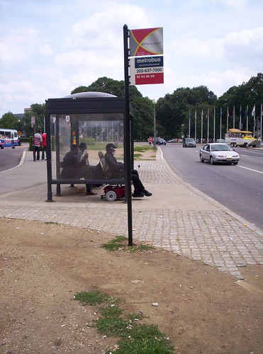
It would rarely need its own stops, and instead share the City-Sponsored JCDecaux shelters, (See this DC stop at Union Station where MetroBus has a Red-White-Blue tricolor and the Circulator has a Red-Silver-X logo:
23894296_e19f86015d.jpg

And here they share just a "flag"
DCcirculator-bus-washingtondc.jpg

The plan kind of reminds me of implementing my university's shuttle system within a big city. Would such a low fare be able to indefinitely fund something like this, or does it need outside donors/gov't help, etc?
Ideally, you'd get sponsors, like the Hubway and get "students" and "employees" on a "corporate" membership. Already the Longwood Medical shuttle plies a pretty prime route across the river and private ones run from Cambridgeside to North Station. Sometimes these make sense standalone, and sometimes they're a good example of how special-purpose buses are needed alongside the MBTA.
 
Last edited:
I don't get this. Maybe I'm a dumbass. Probably, actually. But why do we need a new bus layer, on top of regular buses. That ish just confuses the piss out of people like myself. If the mbta needs a better bus, maybe we should just ask for a better bus. Isn't this basically that track 61 train??
 
I don't get this. Maybe I'm a dumbass. Probably, actually. But why do we need a new bus layer, on top of regular buses. That ish just confuses the piss out of people like myself. If the mbta needs a better bus, maybe we should just ask for a better bus. Isn't this basically that track 61 train??

My east-west route parallels the proposed-but-never-gonna-happen Track 61 DMU shuttle, but other than noting that officialdom is aware of an unmet/unserved east-west need, there is not much more to say. The best Circulators are buses (streetcars are a waste of money and don't allow expirimentation)

The other observation is that the MBTA is a regional commuter oriented system, like its peers MetroBus in DC and the MTA in Baltimore. In DC and Charm City Circulators, the City decided it needed something to circulate people over short distances in the densest parts of the downtown core. Chicago, too, is launching its "Jump" service. In all cases, the city is willing to see bigger operating losses than the regional bus agency would tolerate in the hopes of promoting particular urban activities.

In all instances, the "business case" for the City is to promote shopping and restaurant trips by "office" folks at lunch and after work, and encourage car-free downtowners-- not something their regional transit service was set up to do. "The City" wants an 18-hour downtown service, and the regional authority only has a consensus around weekday rush hours.

The business case ends up calling for lower fares and higher frequencies --just like the kind of shuttles private building owners run at a big loss (low or zero fare box recovery) but intend to make back in other ways.

If it promotes more leisure trips, the city can hope to make it back fairly directly on Restaurant & liquor taxes (and a local sales tax, if any) , and indirectly on property taxes and out-competing suburban alternatives
 
Last edited:
It strikes me that these circulator buses generally serve dense core areas that were missed by their respective cities' rapid transit systems. The proposal in this thread seems to replicate that very service already in place. If the goal is a direct shale from the seaport to Longwood, it should follow the most direct route (bypass road to Melnea Cass to Regales to LMA). Leave the MBTA to service the areas already serviced by the MBTA.
 
I think this is necessary in DC because the Metro doesn't have great coverage on the tourist areas, all told - prime example is Georgetown. Also, the lines converge in places where tourists don't necessarily want to be, beyond a few attractions - for example Chinatown and L'Enfant. The MBTA actually works incredibly well for tourist circulation around Boston, and lines converge in and run throughout the prime tourist mecca.(Only a few counter-examples I can think of, like Navy Yard.)
 
^ The 93 does go through the Charlestown Waterfront, besides the Partners and Spaulding shuttles and the innumerable private tour busses, trolleys and ducks that trawl by the Constitution's dock.
 
The buses themselves are not designed for "crush loading", but rather easy-on/easy-off, so they have larger doors (and 3 of them) and have larger windows too.
circulator3.jpg


It is mostly low-floor , and seats "face the door" in the middle (perched on the wheel hump)

l.jpg


Different users needed different buses.

These are made by VanHool and are just a different (and I think, interesting) design for city buses that maximizes the low floor space.

AC Transit uses these models. Actually, they use a lot of different models it seems (mostly VanHool). I think I got on a different model of bus every single time I used one in my trip to Berkeley.
 
The other observation is that the MBTA is a regional commuter oriented system, like its peers MetroBus in DC and the MTA in Baltimore. In DC and Charm City Circulators, the City decided it needed something to circulate people over short distances in the densest parts of the downtown core. Chicago, too, is launching its "Jump" service. In all cases, the city is willing to see bigger operating losses than the regional bus agency would tolerate in the hopes of promoting particular urban activities.

In all instances, the "business case" for the City is to promote shopping and restaurant trips by "office" folks at lunch and after work, and encourage car-free downtowners-- not something their regional transit service was set up to do. "The City" wants an 18-hour downtown service, and the regional authority only has a consensus around weekday rush hours.

The business case ends up calling for lower fares and higher frequencies --just like the kind of shuttles private building owners run at a big loss (low or zero fare box recovery) but intend to make back in other ways.

OK, I'm getting it now. It serves a different purpose than the T and other busses. BUT it still seems kind of like a bandaid. It is a fix for a metro system that is designed for suburban residents instead of urban residents. We know we can't/won't reorient the entire system any lifetime soon, so this circulator concept fills a gap.

I have one major issue remaining - traffic. With the exception of Sundays, I can walk to the Fenway faster than the 1 bus will move me. Now, maybe that isn't the best counter example for a downtown circulator, but I also have driven downtown at 5pm and it isn't pretty especially near SS. Can you envision a route with bus/bike lanes or something that will guarantee the thing moves faster than a walk?

Dedicated bus lanes on Atlantic Ave along the Greenway between North and South Stations would work for most of its route. That seems like a good start for a Circulator route.

I don't get why it's called a circulator, though. Is it circular, like roads that are circulators? If so, wouldn't a route that goes something along the lines of Boylston -> Charles/MGH -> Bowdoin -> Haymarket -> Aquarium -> South Station -> Chinatown -> Boylston -> etc. make sense?

Otherwise, N-S station, maybe continuing on to the South Boston Waterfront makes sense.

Also, Charles/MGH to North Station and/or Haymarket via Bowdoin, maybe continuing on to the North End is another good one.
 

Back
Top