Infill MBTA stations

Upon further analysis, it does not appear that Frank G's observations in Toronto were of a downtown subway system with more (or at least much more) frequent stops. One might wish the subway lines downtown and the Back Bay were in different places, but station spacing seems to be in line with Toronto:

Toronto
Yonge Street Line (Yellow) from Dupont to Bloor-Yonge: 14 stations in 5.2 miles for .371 miles per stop
Bloor Street Line (Green) from St George to Castle Frank: 4 stations in 1.5 miles for .375 miles per stop

Total .372 miles per stop

Boston
Orange Line from Mass Ave to North Station: 7 stations in 2.8 miles, or .4 miles per stop
Green from Haymarket to Hynes/Symphony: 8 stations in 3.1 miles, or .3875 miles per stop
Red from Charles to South: 3 stations in 1.3 miles, or .433 miles per stop
Blue from Bowdoin to Aquarium: 3 stations in .7 miles or .233 miles per stop

Total: .376 miles per stop
He's talking about the Red Line, and you have omitted the Red Line.

Red Line stops are one mile apart --and, yes, this is too far for convenience and urban cohesion.
 
I was in Toronto last week and I was impressed by the density of the downtown subway stops. ... For example, I know the area between Central and Kendall has been heavily developed in recent years, with University Park, the biotechnology industry, and so on. It seems like a new Red Line station would be popular with the folks living and working there, and encourage continued development and growth.

^ He's also talking about Toronto's downtown. I think Central Square in Cambridge is a very important and interesting urban place, but it is not in the city center. When you move outside of central Toronto, station spacing starts to grow to the lengths seen on the Cambridge stretch of the Red Line. I did include the CBD portion of the Red Line in my analysis, however.

No argument here that one mile station spacing is too far for urban convenience, but outside of NY or Chicago I'm not sure we have any examples of more closely-grouped outlying stations on this continent.
 
I heard a story that when they were originally planning the Cambridge subway there was a dispute whether to have 5 stations or 2, since 5 would serve Cambridge better but would mean longer trips for people living past Harvard Sq and 2 would serve these people over Cambridge residents. We got 3 stations as a compromise.

You could easily imagine two extra stations, one between Kendall and Central and one between Central and Harvard. But if they were going to add infill stations they should build a second set of tracks for express trains, though I don't see the point unless there is a massive amount of growth in Arlington and Lexington.
 
An infill station wouldnt even be that expensive, since the track is very close to street level and the line has established that side platforms are ok. It would be much cheaper than extending the line north for example.

However, why not play around with the green line union square extension to service cmabridge? Combine it with the urban ring and everyone is happy.
 
Google Maps has the distance between Kendal and Central Sq. Stations as being .9 miles and estimates you could walk it in 18 minutes. That means that if you were smack dab in the middle of the two you'd have to walk .45 miles for an estimated 9 minutes to reach a station. Keep in mind that Google Maps' walking time estimations are based on how fast a little old lady pushing her shopping cart could make it, so the average walking time for a normal person is probably something more like 6 or 7 minutes. If we put a station in the exact middle, we'd have a 3 or 3 1/2 minute walk.

So, the question is, are we really going to spend a million plus dollars on a station just to save people 3 or 4 minutes?
 
$1M plus? Just the upgrades at Arlington for the Green line is over $30M. A new stations on the redline would easily cost $50M, probably closer to $100M.
 
Charles was an infill station. I don't remember exactly what year it opened, but it was not planned for originally.
 
Charles opened in the 1930s. Originally there was supposed to be an Art Deco tower above the platforms but this was not built due to the Depression. Also Arlington St is an infill station.

Edit: Also Science Park was an infill.

I always felt that they could add an infill station down on the Braintree line in Dorchester, in Popes Hill at Morrissey Blvd.
 
Last edited:
The art deco tower at Charles Station Van mentioned earlier. The image is from Images of America: Boston's Red Line, Bridging the Charles from Alewife to Braintree. If this blatant violation of copyrights is uncool for the board let me know.
3307016545_87d9ba7172_b.jpg
 
The odd thing about Science Park is that by the time the MTA added it, the neighborhood it would have served (West End) was already being demolished.

I'd put that Red Line infill station at Neponset. I'm surprised that the people of south Dorchester haven't been demanding one for the last 40 years!
 
@crash I saw that on your Flickr stream and immediately knew what it was for. Thanks for posting it.
 
There has been talk about a Neponset Station before. The people in Quincy and Braintree would not like it because it would slow thier trains. I also think this neighborhood may have been in too much transition in the past, 'lets push for a station, no better yet let's move'.
 
I could understand the time argument when they first proposed the line back in the 1960s but with the reopening of the Old Colony lines I say that point is moot. Infill a few stations and let those that really need the extra few minutes take the commuter rail.
 
I did a google search thinking there might be a push to add a Neponset station to the red line. There seems to be nothing. I did find some info on stations along the old colony line:
We are now on a very long tangent, and the Old Colony widens to two tracks. The next bridge spans Victory Road, soon followed by a pair of bridges over Morrissey Blvd. Between the bridges, one can see the remains of Popes Hill Station, another abandoned Old Colony stop. Conley street is quickly bridged after which we pass under I-93 again and come alongside Tenean Beach. Redfield St. crosses overhead and we enter the ramp leading to the Anderson Bridge which carries us over the Neponset River. Back in 1960, a fire under the south approach to the drawbridge located here, insured that the New Haven, owner of the Old Colony, would never resume commuter rail service, setting in motion the chain of events leading to the construction of the South Shore Extension. The new Old Colony main now crosses beside us on a bridge built in the 1990s. Beneath the northerly bridge approaches lies the site of the Old Colony's former Neponset Station.
http://world.nycsubway.org/us/boston/red.html
 
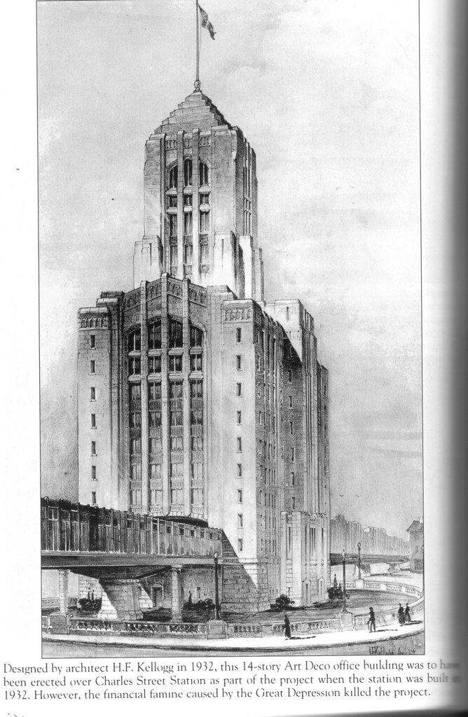
Damn you, Great Depression. Beautiful building. Very cool with the elevated line running through it.

I wonder how many buildings we will be saying that about in twenty or more years, of those that will be stalled or canceled from this era?

So many renderings from that era have an ominous, heavy, foreboding quality to them. Many of the buildings that were fully realized from that era still look that way, despite being given a spit shine-up. See: Suffolk Courthouse and the Federal Building and Post Office.
 

Back
Top