Manchester's West Side

FrankLloydMike

Active Member
Joined
Jun 24, 2010
Messages
514
Reaction score
0
I'm planning to take a look on LivableMHT at how the West Side of Manchester might be improved, and I'm hoping to get feedback and thoughts to incorporate throughout. I also figured that with the recent projects like the CMC expansion and Rimmon Heights neighborhood revitalization, as well as possible and ongoing projects like Granite Landing and the Mill West apartments, the West Side could use its own thread on here.

Here are some images of the West Side:

8c52486r.jpg

Flat Iron District, Notre Dame from ~1940s seen from Simpson Park & Coolidge Ave; one of the towers of Mill West is visible in the background

MILL%20WEST%20panarama.JPG

Present view of the West Side from Downtown with Mill West in the foreground & the Uncanoonucs in the background; Pariseau tower is the beige high-rise at the right; CMC is the lower, beige-ish building to the left; in between Ste. Marie's tops the plateau of Rimmon Heights w/ Lafayette & Simpson parks sloping down the hill between it and shopping plaza where the Flat Iron District previously stood

pic_cmc_6.jpg

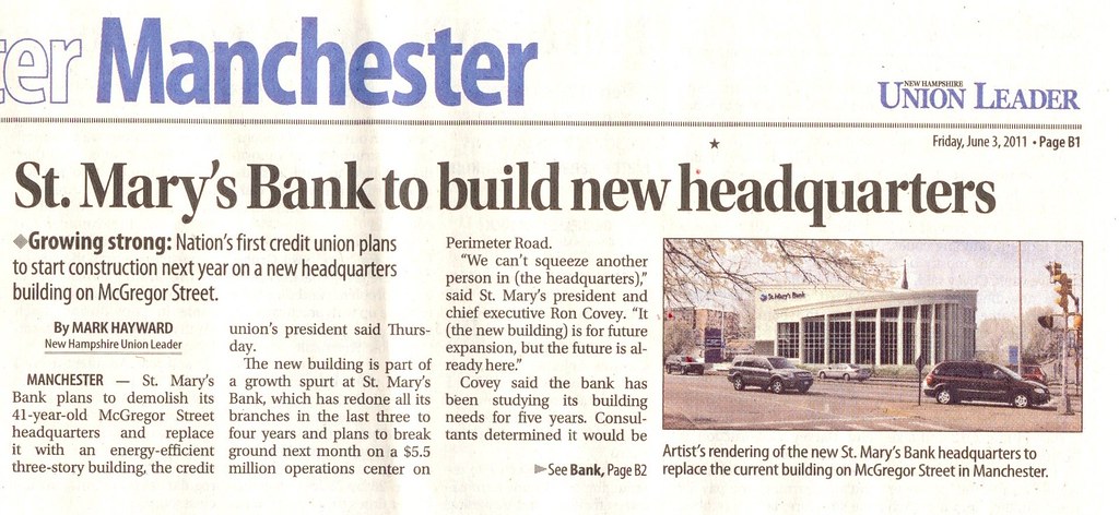
Recent view of CMC parking garage & Notre Dame Pavilion medical offices nearing completion with CMC & the Rite-Aid shopping plaza on the opposite side of McGregor Stret; St. Mary's Bank headquarters is the two-story building in front of the plaza; all the newer parts of CMC, the shopping plaza and the bank were where the Flat Iron District was previously

img00010-20090808-1508.jpg

Present view of Lafayette Park looking over the roof of the shopping plaza with Mill West & downtown visible in the background

untitleddds.jpg

New arches on Kelley Street and Amory Street; this one is at the intersection of Kelley Street & Coolidge & Notre Dame Aves; the brick building is the old St. Patrick's school, being converted to office use

2010-10-0216-01-24.jpg

A recently renovated mixed-use building along Kelley Street, which is a good example of what could be done with other properties along the street; I believe the streetlights have since been replaced with more decorative fixtures
 
For LivableMHT at the moment, I'm specifically planning to look at the area at the foot of Rimmon Heights, where the Notre Dame Bridge, McGregor Street and Amory Street meet around CMC and Mill West. This area was once a dense, commercial and residential section of the Notre Dame neighborhood, and I've seen it called both the Flat Iron District and McGregorville. I'm not sure where the first name came from, but the second is from a man named McGregor who owned a tavern in the area in the late 18th century and was instrumental in getting the first bridge built around that time. As was discussed awhile ago in the Manchester forum, the area was completely razed in one of the city's worst efforts at urban renewal in the 1960s-1970s. The area now is mostly an enormous parking lot, a more than half-empty plaza, the not particularly attractive St. Mary's Bank headquarters, part of CMC (which has recently done a lot to restore a sense of density and a street wall in the area), and the Pariseau tower senior housing.

Sitting at the base of the high plateau of Rimmon Heights, beneath two very well-kept parks and the soaring Saint Marie's church, the Flat Iron District could clearly be an incredibly desirable urban neighborhood. It's just across the river from downtown, but feels like it's own place, is poised as the heart of the West Side (possibly along with a revitalized Granite Square to the south), and is surrounded by revitalized and expanding neighbors, such as CMC, a major city employer, and Mill West, which is currently being converted in part to about 200 apartments. In addition, the 2006 Hillier downtown study recommended attracting R&D type businesses to Main Street, which culminates at the old Flat Iron District.

So here's a map of my initial, schematic take at what a restored Flat Iron District might be like with new, urban development on the site.

I think Amory Street between Coolidge Ave & McGregor Street should definitely be narrowed to be more in keeping with a denser, more walkable neighborhood and feel less like a freeway. I don't see any need for it to be as wide as it is currently. Then, it can be lined with new, denser, mixed-use buildings including a new headquarters for St. Mary's Bank. A new street could be added at the base of Lafayette Park, with retail, residences and offices facing the park on one side and with views of the city on the opposite. I'd like to see a grocery store go in somewhere in the project, and I think the Food Co-op in planning would be great on this site with a cafe facing the park. Rite-Aid owns the entire shopping plaza building and a small portion of the parking lot, so I assume they'd want to retain their building. Depending on their plans and the state of the building, I think the lower end of the plaza could either be replaced entirely, or renovated and built up w/ shops, residences or offices on the second floor at the level of the new park-facing street. A new street would bisect the old plaza, and connect the center of Lafayette Park with the new district as well as McGregor Street. This could all be done in phases, but the site could become one of the most vibrant neighborhood centers in Manchester and a great extension of downtown.
 
Not much to say on each comment but here I go:

The park above the rite aid and St Mary's. Like you had discussed in the past, if a second level were built and basically attached to the park above it would make the park more attractive.

I think more foot bridges connecting the Mills and East side to West side.

Finish restoring the abandoned and not renovated mills.

Be creative with parking lots and not let them take up so much space. Feels too flat with asphalt.

Make the additional bridges not only Granite nicer and more attractive.

Sweeney Park, 3rd St, and northern Second St make them more appealing and that neighborhood area with street upgrades promoting a nicer neighborhood.

That little island across from the city park on second st (bear brook?) Build something here, and incorporate either path near water or make this more park.

Lastly, make the rest of Second st to Bedford nicer, with upgrades and promoting nicer development / facade upgrades. not necessarily much more in terms of better development, just nicer with some street and sidewalk upgrades to promote more walking. But it is so run down. I also dislike the mix of residential and commercial. if it is going to be a mix, do mix use development, not every other building is commercial then residential then commercial etc.

Lots of great thoughts there, and I'm happy to say the City and others are already working on a few of them. Most, however, need more work and planning. The West Side is home to some of the neighborhoods closest to downtown, it is more uniformly urban than the East Side (except for Northwest, which is mostly undeveloped), it serves as the major gateway to the city for most visitors, and connects to the suburbs (Bedford, Pinardville and Goffstown) most directly linked to Manchester.

I doubt we'll see any additional pedestrian bridges in the near future--Hands Across the Merrimack is a refurbished former railroad trestle, and any new bridge would need to be built from scratch. Any bridge between the Granite Street and Notre Dame bridges would have to cross the river and highway, as well as probably crossing the somewhat industrial areas east of Main Street on the West Side, and deal with the different grades on either side. That said, the Notre Dame Bridge is really a sorry replacement for the beautiful, sweeping span that it replaced. I'd love to see it dressed up a bit somehow and the pedestrian amenities improved there similar to what was done recently at Granite Street.

The island on Second Street is Bass Island--Bear Brook is actually a state park in Allenstown. Until a few years ago there was actually a blacksmith across the street from the park, and until the 1936 flood, the island was home to a zoo. Anyway, the City recently announced that the undeveloped land will become a new dog park, which is planning to open next month. I think it's a great use, given how close the park is to the Piscataquog Trail, Riverwalk and Hands Across the Merrimack Bridge, as well as being in a dense neighborhood, but separated from neighborhood residences (who might not want to hear dogs all day) by the river.

Speaking of that neighborhood, I really hope that the areas you mentioned (Sweeney Park, Second and Third Streets) are beautified. I can't remember where I read this, but I believe the City is planning to get rid of the police substation in Sweeney Park, which should make it much more attractive. The park, itself, isn't bad, but it would be much nicer with a restoration of more urban, pedestrian-oriented buildings around and facing it. The church backdrop is nice, but the laundromat and sunken plaza at Granite Square next door should be replaced with something more in keeping with the Barr & Clapp building that was on the site until the 1980s (I'll scan and post a picture soon). I did see a big "for sale" sign on the land southeast of Granite and Second Streets, which is owned by the City and part of the Granite Landing site. I've heard that they're holding out for a high-quality, urban-scale development appropriate to the neighborhood and gateway to downtown, so that would definitely beautify the area.

Second Street from Granite to Hancock at least, and maybe as far as Queen City Ave/Woodbury St is pretty urban and could easily be improved with sidewalk repairs, some more trees, and targeting the area for facade improvement and owner-occupied apartments similar to what is being done in Rimmon Heights and West Granite. South of those areas, Second Street is more of a mess.

Lately, it seems like Bedford has been doing a better job of promoting attractive, mixed-use development along South River Road than Manchester has been doing along Second Street, though both are really moderately urban, but mostly suburban-style strips. Bedford's planning board has been sticking to its recently adopted master plan, and requiring new development in the area to be pedestrian-focused, encourage a mix of uses, and address the street, while also implementing a TIF district to fund street and infrastructure improvements. If they continue to follow through, and the downtown growth continues to spill over into Granite Square, Second Street will be an odd, auto-centric, ugly strip connecting the two, attractive, more urban areas. The City should make sure this doesn't happen, and help Second Street compete with South River Road.

Fortunately, there's really nowhere to build along Second Street except for up and in parking lots, and a lot of the older, even crappy strip-style buildings abut the street. I doubt the auto shops and fast food joints will be leaving anytime soon, but I also don't think there's much chance any more will be showing up. Putting in new sidewalks and trees, reducing curb cuts, and discouraging drive-thrus and street-facing parking would be good ways to easily mitigate the existing auto-focused uses and attract more urban infill. There's a newer building at 956 Second St, home to Chen's Garden restaurant, that has either housing or offices above and abuts the street. The proportions aren't very good and it's not great architecture, but as a more urban-scale project, it's a good example of the right kind of development for the area. Similarly, the recent rowhouses on Hale Street aren't anything special and the parking should be less prominent, but there should be more dense residential like it either just off or above businesses on Second Street.

It might also be helpful to connect the more attract, relatively dense residential areas along South Main and Boynton Streets to Second Street somewhere between Harvell Street and the Bedford line via a pedestrian/bike path similar to the paths in Brookline. This could help make Second Street at least somewhat of a neighborhood commercial district in addition to a commercial strip. A path from Erie Street, or between Allen and Master Street, with a bridge over Mallard Pond could be nice.
 
Here are some more images, which I've added to LivableMHT's facebook page:

252836_205702362804914_193095777398906_525920_4147190_n.jpg

The Flat Iron District (McGregorville) of Notre Dame, West Side before urban renewal, with Lafayette Park and Ste. Marie's in the lower background, and Mill West in the foreground. I'm going to add some labels to this at some point and show an overlay of what has been demolished.

247334_205702419471575_193095777398906_525922_7715643_n.jpg

The previous St. Mary's Bank, which was located at Main & Amory Streets in the heart of McGregorville/Flat Iron. You can see this building in the previous image, just below Lafayette Park.

255041_205702322804918_193095777398906_525918_1913008_n.jpg

The Barr & Clapp Building, Granite & Main Streets, Granite Square. This building was a late victim of urban renewal, falling in the early 1980s to make way for today's very underwhelming sunken plaza and mostly single-story commercial buildings. I don't we ever could (or probably should) rebuild this handsome building, but replacing the current structures with something more akin to this would go a long way to restoring some beauty and charm to Granite Square.
 
That last picture is a nice building.

Anyways, the zoo on bass island? Interesting. Dog park is wonderful to hear. I saw something that at one time it was suppose to become a burger joint, actually looked interesting, but a dog park sounds better.

Foot paths are unlikely like you said, but maybe renovate more of the current bridges like granite to make them more appealing with easy to walk on sidewalks.

Second street does have some buildings with potential I guess. but the sidewalks need improvement, and more beautification. If the buildings' facades are renovated it would be nicer. Although the drive thrus exist there, the reality is they are a part of the way we live now. However if second street including the drive thrus do work on making everything a bit nicer there, I think the overall appearance could be improved and ultimately making it a better walkable as well as shopping area.

And bear brook park I now remember. That place in Allenstown is nice though. got it mixed up. Good biking.

Manchester overall needs to improve their bike paths, bike amenities (lock ups and racks) and an overall city and road bike friendly environment. This gets people out on their bikes and then walking around more too. Bikes though can take you further faster more than walking can and often can be more practical and faster in a city setting than a cumbersome car.
 
There was some big news in the Union Leader last week. Apparently it was only in print, so I'm glad it was sitting on the counter when I visited home this weekend...

St. Mary's Bank is planning to build a new, contemporary building to replace the 1970s blocky one on the site now. The new design will pay homage to the curved, 1930s bank above and I believe will be much closer to McGregor and Amory Streets, giving the area more of an urban feeling. The article also mentions that Rite-Aid is considering redeveloping the plaza. I'll write more about this on LivableMHT, but this is great news for an area that has amazing potential to be a vibrant urban hub for the West Side and complimentary to downtown.

5805459543_bbe77b6c69_b.jpg

5805459339_d035aeaa0b_b.jpg
 
Last edited:
Good. I just hope that Rite Aid does something creative, hopefully street side, and/or incorporating the park above.

I would think that instead of incorporating the park above like you have discussed FrankLloydMike, that I could see the new structure being street side and possibly having stairs or something then built to the park with leaving no building in front (similar to your concept drawing.) I think this is more likely to happen.
 
I've been a bit busy lately and haven't had as much time to look at the Notre Dame Flat Iron area as I'd hoped. I contacted St. Mary's last week to try to get some more information on their new building, but I haven't heard anything yet. I did, however, find an engineering plan as part of a packet of documents submitted to the ZBA a couple weeks ago.

viewer


Obviously, the plan could still be improved--far too much of the site is still devoted to surface parking, for instance--but it's a huge improvement over the current site and a great first step to hopefully restoring the Flat Iron area. I'm glad that in addition to building a taller structure closer to the road (with a respectful, but contemporary nod to the earlier building), St. Mary's is continuing the quasi-road in front of the current plaza to Amory Street and building their new bank up to the city easement for the old alignment of Amory Street. As part of an eventual (and possibly gradual) restoration of a dense, mixed-use neighborhood at the foot of Rimmon Heights, I'd like to see a conversion of the roadway in front of the plaza into a public street between Wayne and Amory Streets, and a narrowing and probably a realignment of Amory to more closely match the historical width and alignment between the parks and McGregor Street. This would not only slow traffic and make for a more intimate, urban space; it would also provide enough space for new construction at the northwest corner of Amory and McGregor in front of a hopefully re-faced Pariseau tower.

In the future, I'd hope to see the odd parking lot to the left of the new bank building (just above the words "McGregor Street") built up. The southern facade of the building is important, then, and I'd like to see what it looks like. Similarly, I'd obviously like the see the bank eventual go without a drive-thru, but more importantly, I'd like to see this project result in a master plan for redeveloping the combined Rite-Aid and St. Mary's sites, incorporating new streets, mixed-use urban structures and replacing the surface parking with a garage. Like I said, though, this is a good first step, and while I'd rather see it more urban and done as part of a master plan with consideration to the larger site, this might an instance where beggars can't be choosers, and hopefully the project will stand as an example for future re-urbanizing of the West Side.

Another thing that must be addressed before any further construction or planning happens is the zoning in the area. Currently, both the Rite-Aid and St. Mary's sites are zoned as General Business District (B-2). This is the same zoning as South Willow Street and other outlying areas. I really don't think it's appropriate anywhere (except maybe a few pockets) in the urbanized area of the city. In addition to Granite Square, Valley Street and a few other areas with promise to be dense, neighborhood hubs, the Flat Iron District should be re-zoned as Central Business District (CBD) or Neighborhood Business District (B-1), both of which prioritize pedestrian and transit-orientations and don't allow auto-dependent uses. The ZBA members seem to appreciate the urban nature of the building and site, and the bank mentions specifically designing the building with pedestrians in mind, but the fact that there are setback lines and (among other things) shows that the zoning is not in line with the goals of the applicants or the board.
 
The only way to have the area be truly ped. oriented is to have it properly zoned. Write to the city in favor of changing it and bringing that idea up.
 
There's been some discussion on the Manchester thread about a proposed liquor store on one of the Granite Landing sites at the intersection of Granite & Second Streets on the West Side. Since the discussion on that thread is much broader, I decided to post these scans of a Union Leader article about a community meeting last month to discuss the proposed liquor store here.

As has been discussed on the other thread, I think most people don't oppose a liquor store in the neighborhood, but rather the idea of a suburban-style, auto-oriented, single-use building going up on such an important and prominent site. People heading to the mountains and lakes already pass the more convenient liquor stores on I-93 in Hooksett, so I doubt a store even right off the off-ramp in Manchester will attract many tourists. It may, however, get some business from downtown workers and cater to residents of the West Side. In that case, I'd much rather see a liquor store--maybe with a few designated parking spots on-street or out back--as part of a larger, urban-scale development. Maybe a second, smaller liquor store could also be built downtown, which would allow workers to pick something up without a second stop in the car on the way home. The point is that the three open lots that make up the Granite Landing area are far too prominent for the city, and have way too much potential to transform the Granite Square neighborhood to squander the opportunity to build something truly urban here.

298689_254919357883214_193095777398906_688980_1541777578_n.jpg

299990_254919241216559_193095777398906_688978_1451412862_n.jpg
 
Last edited:
Does not look promising. There is little - no talk about the actual style of development being suburban vs. more urbanized. It sounds like they are more concerned about getting it built NOW rather than waiting. Of course it has been for sale for two years with little interest because our economy is bad. Don't rush into building something bad on the land just to get a few bucks now.
 
There has been talk about a 293 widening and upgrade. I think it was on here that someone stated that they hate going to Manchester because of 293 having horrible exits. Actually it may have been somewhere else, but either way, someone said it.
 
There has been talk about a 293 widening and upgrade. I think it was on here that someone stated that they hate going to Manchester because of 293 having horrible exits. Actually it may have been somewhere else, but either way, someone said it.

I haven't heard anything about this, but I'd be surprised if they're considering it since it was recently redone and the Granite St exit was improved. There's also very little room to widen it there, and traffic is pretty smooth. I'd guess that the complaint about the exists is from before the Granite Street exit was improved and completed (used to just be northbound off-ramp, southbound on-ramp).
 
http://www.unionleader.com/article/20110930/NEWS15/709309949

I found this. Again, only-in-print...

The exits up past granite street are awful. Exit 6, it is messy, takes up too much room, and is confusing. 101 and 293 and south river road exits are very confusing too. I still screw up on there.

I guess after driving around Massachusetts the past few years has made Manchester seem simple, but you're right about Exit 6 and the unnumbered South River Road exit especially.

It's hard to say from the blurb the UL provides, but it sounds to me like just cleaning up and slightly widening an existing lane as opposed to adding new lanes.

Imagine, though, what could be done for Manchester if instead of spending $33.2 million to spruce up an existing highway, the money went to building the first part of a streetcar line, or adding BRT between downtown and the airport, or commuter rail to Boston, or a light-rail line down I-93, or providing streetscape improvements and just improving the existing bus system. It drives me nuts when I hear complaints about the cost to build and run a commuter rail line or a properly functioning bus system when the cost-per-user is so much higher for highways.
 
Imagine what could be done if the US stops dumping money we do not have into the wars and invested it into our own country.

However I do think 293 needs some work, but transit needs to simultaneously be improved.

Side note, doesn't really have to do with Manchester, but the parking lot near the Haverhill MBTA stop and Downeastern station says MVRAT. Was this funded by the regional tansit department? Or the MBTA? If it was the MVRTA that goes to show regional transportation can be successful.
 
Interesting history of early development of the West Side, particularly Piscataquog Village from Aurore Eaton, executive director of the Manchester Historic Association, in the Union Leader today:

The Piscataquog River was a magnet for progress

Why is there a Main Street on the West Side of Manchester, which is obviously not in the center of the city? The answer is that Main Street (including South Main Street) was originally the major thoroughfare of a town called Piscataquog Village. In 1853 Manchester annexed the village (then part of Bedford), along with Amoskeag Village to its north (then part of Goffstown) — and the West Side was born.

Piscataquog Village grew up on the banks of the Piscataquog River, a tributary of the Merrimack River that starts in Deering and passes through Weare, Goffstown and Manchester. For hundreds of years the river valley, with its deep woodlands, was a favored hunting ground of the Penacook Indians, who called it “the place of many deer” (“piscataquog”). In the early 18th century, the colony of Massachusetts claimed the area near the Merrimack, naming it Narrangansett No. 5. Samuel Bass of Braintree, Mass., was granted possession of the island at the river’s mouth in 1734, and it became known as Bass Island.

The lumber industry was the major impetus for the early development of the region. The large white pines were particularly prized, as pine was used for shipbuilding along the New England coast. By law, the widest and tallest of the pines had to be left standing, reserved for future use for ship’s masts for the royal navy. This law was widely violated by the independent-minded settlers along the Piscataquog.

The harvested logs were floated down the Piscataquog, or dragged by ox teams along a dirt path that became the present Mast Road. The path ran through Goffstown, down what is now Varney Street, and along the Piscataquog to Bass Island. Some of the logs were processed in local sawmills and made into boards, barrels and other products used by the settlers in the region and also for market in Boston. Some of the logs were floated down the Merrimack to sawmills in neighboring towns, or to Newburyport, Mass., for the shipbuilding trade.

The need to transport people and goods up and down the Merrimack River led to the building of a highway. This road was extended north from the town of Merrimack to the Piscataquog River in around 1740. The land along the river here was part of Bedford. The highway continued further north once a wooden bridge was built to span the Piscataquog in around 1760. The bridge at this location was replaced every several years by another wooden bridge, until finally a sturdy stonearch bridge was constructed in 1894. This is now the oldest bridge in Manchester.

Settlers were busy in the vicinity by the 1760s, carving out small farmsteads, and building grist mills to grind grain. As the population grew, the area near the Piscataquog bridge and along the highway developed into the commercial center of Bedford, which was called Piscataquog Village. There were stores, taverns, hotels and manufacturing including the making of carriages and saddles, plus bobbin and shuttle factories and other businesses supporting the textile industry in Manchester.

In the early 19th century cargo boating took hold on the Merrimack River as a fast and cheap way of transporting goods. Often it was logs and boards moving south to Boston, and finished goods shipped up river. Also, cotton and other raw materials were carried in to supply the early textile factories. By 1814 boat traffic extended from Concord to Boston Harbor. The Riddle family of Bedford was involved in the river trade, and in 1816 William Riddle built a large store and boat house just east of the Piscataquog Village bridge. In 1818 he constructed a dam above Bass Island, and canal locks at the mouth of the river.

This allowed him to control the water flow so that boats could load and unload at his boat house. The Riddle store was a major shipping point for merchandise to and from Amoskeag Village, Goffstown, Weare, Dunbarton and other towns.

From 1853 to 1899 the Wallace sawmill operated on the Riddle store site. A large brewery was built nearby, and from 1899 to 1982 West Side Lumber Company occupied the property. The site is now the location of the Bass Island Estates condominiums.

Next week Part 2: A private reserve of exotic animals and a church burns.
 
It's a Christmas miracle: the West Side liquor store is dead. Maybe that's too harsh, but I really think this is much better in the long-term for Manchester. Renting a prominent piece of land with immense potential as a gateway to the city and anchor for the Granite Square neighborhood for $65,000 over 25 years is basically throwing away opportunity. As the economy recovers more fully, this land should be incredibly valuable and the site of much more urban development to live up to its potential, and probably to generate more tax income for the city as a result:

Beth LaMontagne Hall's City Hall: Land deal for liquor store is stalled by contaminated soil

IT'S BEEN A TOUGH year for high-profile land deals. Hackett Hill business park and its fire station are on hold indefinitely; Wellington Hill is skating on thin ice after last week's alderman's meeting; and now the proposed liquor store on Granite Street is dead, too.

Mayor Ted Gatsas said on Tuesday the New Hampshire Liquor Commission would not build a new liquor store on the city-owned plot of Interstate 293 after environmental tests indicated the soil was contaminated and would require costly removal to build there.

Gatsas said the liquor commission is still committed to building a store on the West Side, but this is still a hit for the city. No land lease means Manchester will not collect $65,000 in rent from the state over the next 25 years.
 

Back
Top