MBTA Commuter Rail (Operations, Keolis, & Short Term)

I knew it was LanDsdowne, but probably because as a small child I thought it was Lands Down, as in "that's where the home runs that go over the Green Monster land down."

Sorry to have misled, but it actually isn't. There's no D. That's funny, though!

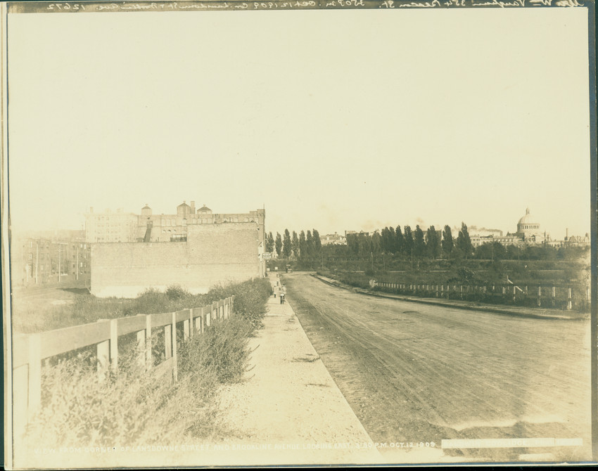
Since we're giving this little road so much attention, here's a picture of it in 1909:

1691scr_fedff0d9e3de66c.jpg
 
Awesome picture. So to the right is the current location of the park?
 
Not that surprising if they wanted to change the name of a station :)


Also, as Vacarro himself noted he realized for the first time yesterday (so did I), the name of the street is Lan D sdowne. The MBTA either decided to educate 4 million people on the actual name of the street or gave the station a name everyone has misspelled and mispronounced for 100 years.

EDIT: I need to correct myself here. Looking at the Boston Parcel Viewer, the MBTA got the name of the street wrong. The City of Boston spells it without a D.

EDIT AGAIN: The MBTA didn't get it wrong - the schedule you posted spells it right. I guess just the press release got it wrong.


If you go to the BPDA's online atlas and look up the Bromley Maps of that neighborhood, the only map that shows the spelling with two Ds is the 1902 atlas, which soon after the street was laid out (and appears to have been a paper street at the time). All subsequent spellings, maps and most documents at the Registry of Deeds have it with one D, so it appears that Lansdowne is the proper spelling. Interestingly, the 1874 atlas shows that that area was reserved for the extension of the Back Bay street grid-without the slight northward jog it takes today at Massachusetts Avenue-with Commonwealth Ave extending right through today's Fenway Park.
 
If you go to the BPDA's online atlas and look up the Bromley Maps of that neighborhood, the only map that shows the spelling with two Ds is the 1902 atlas, which soon after the street was laid out (and appears to have been a paper street at the time). All subsequent spellings, maps and most documents at the Registry of Deeds have it with one D, so it appears that Lansdowne is the proper spelling. Interestingly, the 1874 atlas shows that that area was reserved for the extension of the Back Bay street grid-without the slight northward jog it takes today at Massachusetts Avenue-with Commonwealth Ave extending right through today's Fenway Park.

I was doing that at the same time you were, and found the same thing. I was actually curious whether Lansdowne was named after someone else who could have done something problematic, but I think they're safe there. All the streets around Fenway were plotted and named at the same time, and since they all have English country names it seems likely that Lansdowne Street is named after, of all things, a battle in the English Civil War:

https://en.wikipedia.org/wiki/Battle_of_Lansdowne

Also, I doubt the area was "reserved" for anything. When it comes to 19th Century maps, I've found that mapmakers generally guessed at what might happen in areas intended to be developed. There may never have been a concrete plan to extend the street grid that way.

Awesome picture. So to the right is the current location of the park?

Yep! That's a fleeting moment, though, since over the prior 30 years this area was filled out of the mouth of the Muddy River. The area was, well, mud at the turn of the 19th Century.
 
As I said on UHub, I think it's this guy:

William Petty, 1st Marquess of Lansdowne, KG, PC (2 May 1737 – 7 May 1805), known as The Earl of Shelburne between 1761 and 1784, by which title he is generally known to history, was an Irish-born British Whig statesman who was the first Home Secretary in 1782 and then Prime Minister in 1782–83 during the final months of the American War of Independence. He succeeded in securing peace with America and this feat remains his most notable legacy.
 
As I said on UHub, I think it's this guy:

You're probably right, though since he wasn't known by that name would it have occurred to land speculators 130 years later to use his [EDIT: later] title?

Interesting - the town of Shelburne in the Pioneer Valley is also named for him, if that's where this name came from. He wasn't given the Lansdowne title until after he stopped dealing with America, FWIW. Don't see anything in his Wikipedia entry to suggest bad behavior, though it does seem he was a bit of a jerk to his colleagues.
 
Last edited:
Interesting that the Worcester line has an updated spring schedule, but for every other rail line it's the same.

The MBTA actually updates the schedules more often than you might think, looking at the API we're on the fourth version of the spring GTFS feed already and the spring schedules just came out. And even though that schedule update was released yesterday, it still doesn't have the Yawkey renaming in it yet so I expect a v5 coming soon. Usually its minor things, bus stop closures and moves and the like.
 
If you go to the BPDA's online atlas and look up the Bromley Maps of that neighborhood, the only map that shows the spelling with two Ds is the 1902 atlas, which soon after the street was laid out (and appears to have been a paper street at the time). All subsequent spellings, maps and most documents at the Registry of Deeds have it with one D, so it appears that Lansdowne is the proper spelling. Interestingly, the 1874 atlas shows that that area was reserved for the extension of the Back Bay street grid-without the slight northward jog it takes today at Massachusetts Avenue-with Commonwealth Ave extending right through today's Fenway Park.

And to further complicate things, Cambridge spells its street with two Ds.

https://goo.gl/maps/Maf3L3ajGZN2
 
Yeah, my original question was how long it was going to take to get the maps and signs updated across the rest of the system. There is at least one extant reference to "Arborway" that I'm aware of, so I'm not holding out hope.

Plus, there're also plenty of maps that still need to be updated to show Blue Hill Avenue -- a whole new station built within the city of Boston! A shame it hasn't been trumpeted louder.

But, most important from this news: we have the MBTA Station Naming Policy, so the nerding and nitpicking may now commence.

I'm wondering it's it's more sensible to hold out on updating some of the station maps (significantly more expensive to change than the paper ones on vehicles, we're talking thousands for these damn things, don't know how) until GLX/SCR which are set to finish at similar times and will be the first large change to the map in years. Though they did a pretty good job with all the stickers to show SL3 and Wollaston closures.
 
^ I bet it'll be stickers, which I agree, they've used pretty consistently with SL3, Wollaston and the GC closing.

Hopefully a full proper update of all system maps will indeed come, as you suggest, after the opening of GLX.

But on what planet is SCR likely to finish at the same time? Is there any actual work (i.e. construction crews on the ground) being done on SCR right now?
 
But on what planet is SCR likely to finish at the same time? Is there any actual work (i.e. construction crews on the ground) being done on SCR right now?

Yes there is actually. The NTP for early action culverts has been issued, the contract for early action bridges is actively being packaged for bidding and the previous early action contracts that have replaced several bridges and grade crossings along the route have already finished construction. MassDOT has also already issued orders for interlockings and certain special track pieces. 100% design was achieved in February and this month and into next month work is centered around handing off the design to a new PM/CM team who will be managing from now onwards. Once that handoff is complete final construction will begin on laying track, redoing the final grade crossings and signals. Given that it's not near active rail lines construction can go much quicker.
 
Yes there is actually. The NTP for early action culverts has been issued, the contract for early action bridges is actively being packaged for bidding and the previous early action contracts that have replaced several bridges and grade crossings along the route have already finished construction. MassDOT has also already issued orders for interlockings and certain special track pieces. 100% design was achieved in February and this month and into next month work is centered around handing off the design to a new PM/CM team who will be managing from now onwards. Once that handoff is complete final construction will begin on laying track, redoing the final grade crossings and signals. Given that it's not near active rail lines construction can go much quicker.

That is all freight work that's been ongoing for 2 years on the Framingham Secondary + Middleboro Secondary to enable exchange of 286,000 lb. carloads between CSX and Mass Coastal RR (up from 263,000 lbs.) at a brisk 25 MPH instead of 10 MPH. It's gotten far enough along in CSX territory that they're cueing up for Mass Coastal territory. Every single time anything gets touched down there the SCR Task Force PR flaks bleat out their asses that "South Coast Rail is beginning!" It signifies no such thing. These are all state-of-repair I.O.U.'s negotiated with CSX 11 years ago when they made the $100M Beacon Park relocation transaction with the state, so CSX could get back in increased interchange revenue what they gave up territorially. Such work has been happening periodically all decade long down there, and the same exact scope of work that's happening now would be happening whether or not the SCR passenger project were outright canceled.

They've been replacing bridges, culverts, crossing surfaces, crossing protection, and switches everywhere from Framingham to Medfield to Walpole to Foxboro to Mansfield to Attleboro to Taunton to Middleboro. While it will help with lineside state-of-repair if/when the passenger upgrades start, these jobs are all requirements for doing Class 2/286K freight track and nothing they are doing right now goes above-and-beyond that. There's no money appropriated for stations, no money appropriated for a signal system, no money appropriated for passing tracks or automatic interlockings, no money appropriated for layover yards, no money appropriated for expanded equipment requirements. As well as town of Middleboro threatening to sue over the abandonment of the existing TOD-successful M'boro Station for the inferior location at Pilgrim Junction, and Taunton threatening to sue over switching Taunton Depot away from its namesake shops into a barren swamp. Not to mention no traffic modeling yet released for these schedules being plugged into the Old Colony mainline, so every other town on the Middleboro, Plymouth, and Greenbush Lines may be feeling the lawsuit fever over stopping Phase I if they see their already meager schedules get reduced over propping this turkey up.

SCR is about as close to happening in the real world as it was 10 years ago. It's still a broken planning mess in no way ready for prime time, because the choices they made to bootstrap this Phase I literally don't work on a schedule and literally will get them sued by multiple member towns en route. Yet the state in its desperation will keep issuing breathless press releases that every time the freight railroad runs a weed-sprayer along the tracks that the inaugural run is...right...around...the...corner.
 
Well an inbound Rockport train derailed near Sullivan this morning.
 
Tell that to my colleagues who have spent the past 7+ years working on it. Regardless of questionable choices made by the state, 100% design of Phase 1 is here and that's a big milestone, definitely wasn't this far along 10 years ago. And the early action items were designed and paid for as part of SCR regardless so I consider them part of the project. Agreements have been made with most municipalities at this point, (along with a few station name changes, not sure if they're public yet). Environmental permitting is almost complete. Construction is expected to actually begin Q1 2020 if you ignore the ongoing early action packages.

You work on SCR?
 
Holy shit there was a collision outside of South Station. https://www.bostonglobe.com/metro/2...sing-delays/N2JwPaKmA4TzhX2EHiGw1N/story.html

Edited to add NBC article, which has a photo, no paywall, and no mention of collision, just derailment. https://www.nbcboston.com/news/loca...s-Delays-on-MBTA-Commuter-Rail-508351921.html

Yeah, that's a very weirdly-written Globe article. It stopped saying "collided" after the third graf and then went exclusively with "derailment" as if there were uncertainty. Read like it was being edited in real time. I read Channel 5's report and it was more coherent about there indeed being a collision/sideswipe as root cause for the derailment.

ID'ing the location from the photos, this happened between the W. Broadway and W. 4th bridges, closer to W. Broadway. Which is smack in the middle of Broad Interlocking where Fairmount, the Old Colony, and Amtrak Southampton Yard all split from each other in a span of a little over 500 feet. It's one of the most complicated interlockings on the entire system comprising dozens of switches for all the crossovers, splits, and recombines in that compact area...which is why the speed limit in that spot is so low.

Odds HIGHLY favor a split switch as cause for that kind of sideswipe collision and derailment. It's one of the most common types of rail accidents in the world, and has happened at this very spot--with similarly benign results--periodically throughout South Station's entire history. As well as pretty much every remotely complex rail terminal in the world. Thankfully, the very complexity of the interlocking makes it a minimum possible speed limit so it's nearly impossible to do major damage or shake up that few passengers on board. If it weren't for the 11:00 news and siting next to a very easy bridge to photograph off of, this is the kind of thing you'd hear about the next day only...after Joe Pesaturo had written all the reporters' talking points for them. But...it happened when all the local newsrooms were looking for a leadoff story, so we get a little amped-up disastertainment out of it on a Tuesday night.

According to a WBZ article, a Keolis spokesperson said

“The initial findings from this investigation indicate human error was likely a factor,” Justin Thompson, a spokesman for Keolis which runs the commuter rail, told WBZ-TV. “It appears that the out of service train did not adhere to a properly displayed red signal, which instructs the crew to stop and not proceed past a point. The involved train crew is currently not in service.”

F-Line, would positive train control and automatic train control that the MBTA is spending tons of money on have prevented this?


South Station already has cab signals providing stop/speed control, but engineers can override at sub-10 MPH because cab signal dropouts can happen inside yard limits when there's a jungle full of switches like Broad Interlocking. Compared to the NJ Transit Hoboken Terminal disaster of a couple years ago, this wasn't an overspeed situation...just speed limit (or less) blowing a red. Thus, not really anything you can blame the signals for because there wasn't a loophole like in Hoboken allowing a speedup. The infrastructure performed exactly as designed minimizing the only possible accident vector to a minimum-speed scrape over a split switch.


Not sure if the ACSES PTC system that's been active on the NEC for 18 years reaches the Broad side of the terminal. Pretty sure it's not and only (for now) is active from where Cove Interlocking on the other side gives way to the start of the NEC mainline. Whether it would've prevented this remains to be seen, as we don't know second-by-second each train's positions approaching the switch. It's possible the PTC would've acted sooner with a penalty stop. It's also still possible to overshoot the red and split the switch with a late braking application that has the train skidding across the switch in the act of stopping...in which case, same exact collision in spite of the PTC. As mentioned, ultra-low speed yard whoopsies are so far and away the most common type of rail accident...so that loophole can never physically be closed tight, just ever more minimized with time.
 
Is there any update on when the new platform at Ruggles will be open? Everything I can find is from last year.

Does that project also include rehabbing the existing platform so they can actually use the whole thing?
 

Back
Top