Not Just Bikes & Strong Towns | Stories of Great Dutch Cities & Better Urban Planning

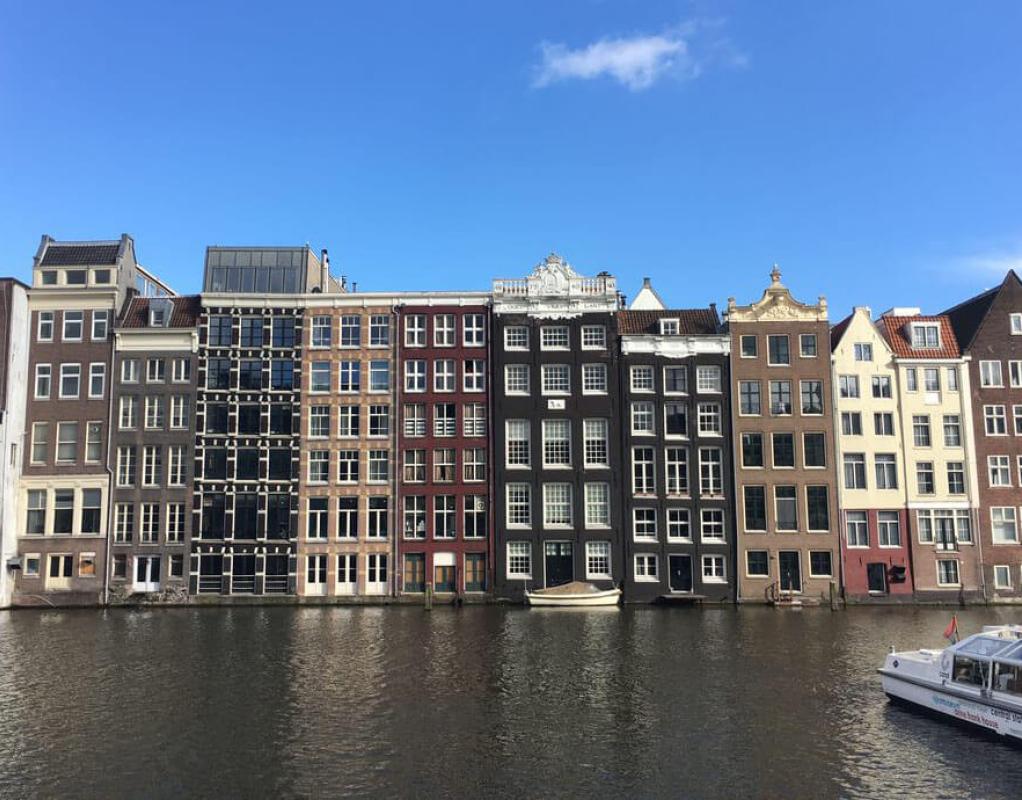
I was just recommended an interesting video by “About Here” who talks about why apartments in north America are so large and end up as 5 over 1 style 90% of the time vs in other countries where you can have 5-6 story buildings that are very skinny and much more varying in size. In the US every building above 3 stories has to have 2 stair cases (except in a couple cities who opted out), which leads to very wide buildings with central hallways. In essentially the entire rest of the world besides the US and Canada buildings are only required to have 2 stair cases above 6 stories. This means up to 6 stories they are allowed to only have 1 staircase, which means they are still allowed to build buildings like this, which is very hard to build in the US.

dutch-canalside-houses.jpg


Heres the link to the video:
 
The high speed rail line in the Netherlands between Amsterdam Zuid and Rotterdam Centraal station seems to have failed inspections, as a handful of cracks and defects were identified within the various viaducts that carry the HSL tracks.

A total of 17km of HSL track is now placed under 80kmh speed restrictions on the HSL Zuid line in the Netherlands. These speed restrictions will remain in place until December 31st 2025. (The end of 2025).

Normal operating speed of the HSL Zuid line is 300 kmh for international trains and 160 kmh for domestic trains.

These speed restrictions mean that effectively the Dutch high speed rail line is only high speed from Breda to Rotterdam, due to the 17km long speed restriction at 80kmh between Rotterdam Centraal and Amsterdam Zuid.


This seems reminiscent of the MBTA slow zones that will remain in place on some MBTA subway lines until January 1st, 2025.
Fun fact: NS originally got burned badly on trains for this line that were incredibly unreliable (The V250s) that were made by none other than AnsaldoBreda (Of Type-8 fame).
 
A pretty good find to map out walkable areas of Boston:


1712342739812.png
 
A pretty good find to map out walkable areas of Boston:


View attachment 49291
It’s a cool map, but just based on the areas I’m familiar with I’m a little skeptical of how robust the data is…Random patch of Weymouth is lit up but Quincy Center is dark? The library is right there as are multiple grocery stores/pharmacies and of course corner stores and public transit stops.

Edit: Going further, a lot of the D line and even chucks of the B/C look dark.
 
Last edited:
A pretty good find to map out walkable areas of Boston:


View attachment 49291

The frequent transit map as plotted by close city is very darn close to my MBTA frequency map. Compare the following 2 maps side by side:

Bus/Subway frequency map: https://archboston.com/community/attachments/1711493734652-png.48977/

1712343277130.png
 
Last edited:
It’s a cool map, but just based on the areas I’m familiar with I’m a little skeptical of how robust the data is…Random patch of Weymouth is lit up but Quincy Center is dark? The library is right there as are multiple grocery stores/pharmacies and of course corner stores and public transit stops.

Edit: Going further, a lot of the D line and even chucks of the B/C look dark.
Yeah, that's my quick take on this, too. I live a block from both a library and a supermarket, yet my neighborhood shows as dark. If they can get a more robust data set, it will become a useful tool.
 
A pretty good find to map out walkable areas of Boston:


View attachment 49291
StreetsBlog MASS now has an article covering this tool (that I found on the urbanism social media)


Medford/Tufts being a food desert is kinda odd. Malden is a huge island, where it's only good if one is a stone's throw of Malden Center T-stop, otherwise, it's quite isolated. Quotes from the article:

while others decry how the area around Tufts University in Medford resembles food desert conditions

But on that same note, the only train stops are on the west side (the Orange Line stops at Malden Center and Oak Grove) which can be an almost 20 minute bus ride or hour walk coming from the other side of town.
 

Back
Top