Old bridge Boston

urbanmapper

New member
Joined
May 8, 2013
Messages
10
Reaction score
0
Hi all,

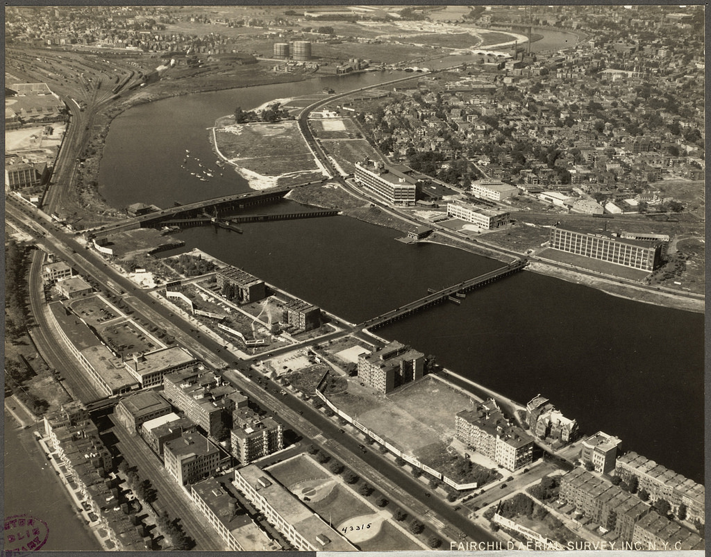
I'm trying to find the history of a bridge. In this photo purporting to be from 1920, there is a bridge downstream of the BU bridge. I can't find any map with it on Ward Maps old maps, nor any mention anywhere else. Anyone know the history?

Thanks!
 
Hi all,

I'm trying to find the history of a bridge. In this photo purporting to be from 1920, there is a bridge downstream of the BU bridge. I can't find any map with it on Ward Maps old maps, nor any mention anywhere else. Anyone know the history?

Thanks!

It was a temporary bridge that only existed for a few years while the BU Bridge's (a.k.a. Cottage Farm Bridge) and Grand Junction railroad's predecessor spans were torn down to erect the current BU Bridge + rail span. They needed to dismantle the road bridge entirely in order to replace the rail span underneath with the current fixed bridge without disrupting mission-critical freight service on the old drawbridge trestle. Since that entailed a few years with the road span completely out, they needed a temp bridge to handle the trolleys that ran on the route of the current 47 and CT2 buses. Was purely a barebones wood trestle with a draw span that only opened so the construction barges could get to and from the main bridge construction site, and it was weight-restricted to just passenger cars and one trolley at a time...no trucks or multiple passing streetcars. It was closed and torn down without a trace as soon as the new bridge opened and the streetcars could return to their normal route.

The present-day equivalent would be one of those MassHighway 'erector set' flimsy metal temp bridges they sometimes throw up when a major water crossing has to go down for the count to get replaced. The temp Fore River drawbridge on Route 3A in Quincy would be a maximum-complexity example of a temp crossing. That Charles River trestle in the pic is basically the century-ago DOT equivalent of a Fore River-type temp replacement span.


That's a fairly well-circulated pic taken by construction surveyors as a "before" shot of the main bridge construction. Pretty much the only pic in existence showing both of them open for traffic at the same time. Main span was closed for demolition very soon after.

That's fantastic stuff! Thank you!
 
Boston%2Bin%2Bthe%2B1920s%2B%25281%2529.jpg


The bridge at St Marys St was built as a temporary crossing when the deficient,wooden, 1850s Brookline Bridge (shown in the picture) was replaced with the current Cottage Farm (now B.U.) Bridge.
WORK ON TEMPORARY BRIDGE WAS BEGUN ON TUESDAY
Work on a temporary bridge between Boston and Cambridge to take the place of the Cottage Farm bridge while the new structure is being erected started Tuesday at a point opposite St. Mary's Street, Boston. It is expected that the erection of the temporary bridge will take about three months and that contracts for the new bridge will be ready for bids in September, it is understood that the contracts will include the removal of the old structure and that work will commence on the new bridge as soon as the old one is removed. In the meantime, an appropriation of $15,000 has been made for temporary repairs to the old bridge to keep it in condition for use until the temporary bridge is completed. The work is being done under the direction of the metropolitan district commission which has been placed in charge by the act passed by this year's legislature.
Cambridge Chronicle: June 23, 1923

What is interesting was there was considerable debate opposing the Cottage Farm bridge, instead favoring a new bridge to be built connecting Magazine St to St Paul St.
City Fathers in 1894 Picked That Location, Abolishing Present Cottage Farm Bridge in Park Department's Plan for River Front and Bridges Reproduced by the Tribune This Week—Narrow Vision, Cheap Politics, Selfishness and Sentimentalism Have Since Eclipsed Sound Judgment
Cambridge Tribune: March 20, 1923
 
Boston%2Bin%2Bthe%2B1920s%2B%25281%2529.jpg


The bridge at St Marys St was built as a temporary crossing when the deficient,wooden, 1850s Brookline Bridge (shown in the picture) was replaced with the current Cottage Farm (now B.U.) Bridge.

Cambridge Chronicle: June 23, 1923

What is interesting was there was considerable debate opposing the Cottage Farm bridge, instead favoring a new bridge to be built connecting Magazine St to St Paul St.

Cambridge Tribune: March 20, 1923

I'd seen the first article (I posted it somewhere on this site a year or two ago) but not the second. "Boston is a laughing stock to the world" - amazing - obstructionism was already in full force then. What a shame - as the article points out, the Cottage Farm Bridge dead ends on the Boston side, and requires twists and turns to get anywhere. Would've made SO much more sense to build the bridge at Magazine, lined it right up with Pleasant Street on one side, and Prospect St on the other....
 
I'd seen the first article (I posted it somewhere on this site a year or two ago) but not the second. "Boston is a laughing stock to the world" - amazing - obstructionism was already in full force then. What a shame - as the article points out, the Cottage Farm Bridge dead ends on the Boston side, and requires twists and turns to get anywhere. Would've made SO much more sense to build the bridge at Magazine, lined it right up with Pleasant Street on one side, and Prospect St on the other....

Really? The BU Bridge doesn't dead end on the Boston side, it's a direct connection to Park Drive and Longwood. On the Cambridge side, connecting to Magazine would have brought traffic from 3 bridges directly into Central Square, which would have been a traffic disaster (granted, this was before the Turnpike and A/B Interchange), while leaving the Future Kendall without the connection via Brookline Ave.

I think the current alignment has some bonuses.
 
I'd seen the first article (I posted it somewhere on this site a year or two ago) but not the second. "Boston is a laughing stock to the world" - amazing - obstructionism was already in full force then. What a shame - as the article points out, the Cottage Farm Bridge dead ends on the Boston side, and requires twists and turns to get anywhere. Would've made SO much more sense to build the bridge at Magazine, lined it right up with Pleasant Street on one side, and Prospect St on the other....

Magazine-to-Pleasant/Agganis Way wouldn't ever have worked. Agganis Way is at-grade, with just a short retaining wall above the RR tracks. Back then the grandstand entrance to Braves Field, the main entrance to the then-active Armory, and the small trolley carbarn at the back of the Armory active till 1962 for B Line short-turns were all packed way at the end of the street, preventing any sort of elevation of the roadway onto a bridge that could cross the tracks en route to the river. The hill BU Bridge sits on is the literal last jumping-off point until Cambridge St. on the other side of Beacon Park.
 
Back then the grandstand entrance to Braves Field, the main entrance to the then-active Armory, and the small trolley carbarn at the back of the Armory active till 1962 for B Line short-turns were all packed way at the end of the street, preventing any sort of elevation of the roadway onto a bridge that could cross the tracks en route to the river.

F-line - how in the world do you know this stuff?
 
F-line - how in the world do you know this stuff?

Well...Google Street View shows you that the street is at ground level, and Historic Aerials can pinpoint the other structures relative to the end of the street. Anyone who ever attended BU got the line from the campus tour that the last surviving original structure from Braves Field is the current Nickerson Field grandstand, near the end of the street. I spent plenty of time playing pickup games at the Armory when I was at BU and know where that entrance was. And there used to be streetcar tracks sticking out of the old cobblestone pavement at the back of Agganis Way right up until they tore down the Armory; that short-turn layover is well-documented and well-photographed since it lasted in-service until just 2 years before dawn of the MBTA. And I first saw that photo of the temporary Cottage Farm Bridge in a feature article in the BU alumni magazine about the history of the BU Bridge, written right before the most recent reconstruction project started.
 
Really? The BU Bridge doesn't dead end on the Boston side, it's a direct connection to Park Drive and Longwood. On the Cambridge side, connecting to Magazine would have brought traffic from 3 bridges directly into Central Square, which would have been a traffic disaster (granted, this was before the Turnpike and A/B Interchange), while leaving the Future Kendall without the connection via Brookline Ave.

I think the current alignment has some bonuses.

Maybe so. But sometimes I wonder though if we wouldn't really be better off with BOTH alignments, plus something like 4-7 more crossings between the Harbor and Harvard. Someone said it a couple years ago here - if Cam and Bos were a single city then the density of crossings (outside the basin, except maybe the Dartmouth St. plan) might look more like it does on the Seine ... if not quite as en-gridded as the Chicago.... have always suspected that this was one of the Original Sins of intra-regional mobility in the GBA....
 
^ I agree... I imagine if the Magazine, St Mary's, and Dartmouth Street bridges were built, the quite real barrier of "crossing the river" wouldn't be as extant.
 
davem, thanks for the photo. Those illuminating gas tanks on what is now Harvard-owned property explain some of the remediation cost associated with building between Western Ave. and Cambridge St.
 
In the background, the River Street bridge is just under construction. Two of the arches look to be completely in place, but the third arch closest to Allston seems less complete than the others. And aside from the arches themselves, the rest of the structure looks to be not yet there. When I squint, I think I'm seeing the faint outline of a crane on the Cambridge side.

Wikipedia says that bridge was built in 1925. I never place full faith in details found on Wikipedia, and their footnote link (re: the construction date) to a MassDOT site is broken, so take that with a grain of salt. Perhaps Wiki meant completed in 1925.
 
Maybe so. But sometimes I wonder though if we wouldn't really be better off with BOTH alignments, plus something like 4-7 more crossings between the Harbor and Harvard. Someone said it a couple years ago here - if Cam and Bos were a single city then the density of crossings (outside the basin, except maybe the Dartmouth St. plan) might look more like it does on the Seine ... if not quite as en-gridded as the Chicago.... have always suspected that this was one of the Original Sins of intra-regional mobility in the GBA....

You have to also consider the landfilling timetable. The original Cottage Farm Bridge was built in 1850. This is Cambridgeport in 1854, 8 years after Cambridge seceded from Boston. The box drawn through the water is the current riverbank.

1854-Site-01.png


Brookline St. and Main St. were the shoreline. The Grand Junction RR ran on a causeway trestle. All of that shaded region out to Waverley/Albany St.'s lacking a street grid was just-completed landfill. And then if you log onto Historic Aerials you can see that it took until 1905 for them to finish landfilling between Vassar and the current riverbank. And then when the final riverbank was set, they immediately started doing replacements of all the former trestle crossings of the channelized Back Bay...Longfellow, Mass Ave., Cottage Farm, and whatever else was upstream. Involuntarily in some cases, because the changed topography required changed crossings.

There was no time to plan a whole master grid of crossings. This fill was only 20 years old in 1925. And they were in the midst of a furious schedule of SGR replacements of any pre-existing Charles Basin bridges, not all that much unlike what's happening today except at a faster pace. When the SGR work was done...they were already planning to build Soldiers Field Rd. to pass under the new BU Bridge.

If the landfilling had happened more gradually you'd probably have seen more of a grid strung together. But it wasn't gradual; it was a compressed timeframe. With the last pieces being 20th century origin. Cambridgeport filled in with bursts, and that 1900-05 final push to carve out the present-day MIT campus was a really big one with lots of reconstruction dependencies on the pre-existing street grid.
 
F-Line -- yo wrote "You have to also consider the landfilling timetable. The original Cottage Farm Bridge was built in 1850. This is Cambridgeport in 1854, 8 years after Cambridge seceded from Boston. The box drawn through the water is the current riverbank."

Cambridge seceded from Boston?

from the wiki
The site for what would become Cambridge was chosen in December 1630, because it was located safely upriver from Boston Harbor, which made it easily defensible from attacks by enemy ships. Thomas Dudley, his daughter Anne Bradstreet and her husband Simon, were among the first settlers of the town.

The first houses were built in the spring of 1631. The settlement was initially referred to as "the newe towne".[5] Official Massachusetts records show the name capitalized as Newe Towne by 1632, and a single word, Newtowne, by 1638.[6] Located at the first convenient Charles River crossing west of Boston, Newe Towne was one of a number of towns (including Boston, Dorchester, Watertown, and Weymouth), founded by the 700 original Puritan colonists of the Massachusetts Bay Colony under governor John Winthrop.

The original village site is in the heart of today's Harvard Square. The marketplace where farmers brought in crops from surrounding towns to sell survives today as the small park at the corner of John F. Kennedy (J.F.K.) and Winthrop Streets, then at the edge of a salt marsh, since filled.

The town included a much larger area than the present city, with various outlying parts becoming independent towns over the years: Newton (originally Cambridge Village, then Newtown) in 1688,[7] Lexington (Cambridge Farms) in 1712, and both West Cambridge (originally Menotomy) and Brighton (Little Cambridge) in 1807.[8] Part of West Cambridge joined the new town of Belmont in 1859, and the rest of West Cambridge was renamed Arlington in 1867; Brighton was annexed by Boston in 1874. In the late 19th century, various schemes for annexing Cambridge itself to the city of Boston were pursued and rejected.[9][10]

In 1636, the Newe College (later renamed Harvard College, after benefactor John Harvard), was founded by the colony to train ministers. The Newe Towne (later named Cambridge) was chosen for the site of the new college by the Great and General Court (the Massachusetts legislature)...primarily, according to testimony by Cotton Mather, to be near the highly respected, popular Puritan preacher Thomas Shepard. By 1638, the name "Newe Towne" had "compacted by usage into 'Newtowne'."[5] In May 1638[11][12] the name was changed to Cambridge in honor of the university in Cambridge, England.[13]

......Cambridge was incorporated as a city in 1846. This was despite noticeable tensions between East Cambridge, Cambridgeport, and Old Cambridge that stemmed from differences in each area's culture, sources of income, and the national origins of the residents.[17] The city's commercial center began to shift from Harvard Square to Central Square, which became the downtown of the city around this time.

Perhaps you were referring to when Cambridge became a city or perhaps you were thinking about Brighton which was ultimately annexed by Boston
 

Back
Top