Pope Building and Its Neighborhood

tobyjug

Senior Member
Joined
Jul 21, 2007
Messages
3,392
Reaction score
413
I though it might be interesting to discuss how (if) this area can be developed in a pleasing but practical nature. Let's look forward!
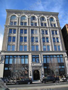
Pope Building.

nedshouse.jpg


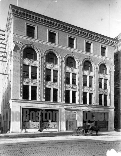
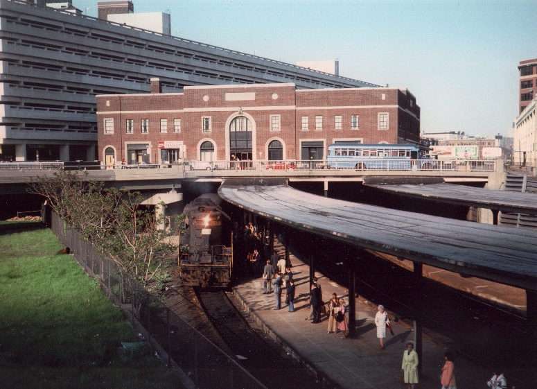
This is how the area looked before the John Hancock Parking Garage, and before Copley Place. The taller brick building on the left is the University Club. I had my first trip to a swimming pool there about 47 years ago. The U.C. hit financial difficulties in the 60's, and sold its clubhouse to Hancock. It is now a Hancock's visitors center, but the Club leases back the front section, and thrives.
Originally the U.C. was all male, but is now mixed. Once in a while, an ancient member forgets, and will arrive naked in the pool area.

ned.jpg
 
The Pike even ooks ghastly new...
 
Was the gash widened to become the Pike or was that wide when it was rail?
 
It was widened, from what I've seen on old maps.

Is the Pope Building still standing, or was it demolished to make way for the Pike? I can't quite tell from your first post.
 
What is the Pope building - is that where Mistral is? With the highway and train tracks as it's front yard?
 
I think I know the answer, but I (mis)remember a post that said Ned lives here. Ned: please give us the history of the building, how it grew in height (twice?), what Pope made, whether Mistral is a good neighbor, etc.
 
Last edited:
Yes, that's where Mistral is, sans the newly added penthouse. It is to the left of the Metropolitan Club/Mitchell Gold store, in the building Louis Sullivan designed, now sans it's rich cornice/balaustrade, which you can just see in the upper right corner.
 
Ned's not here. He's in 75 Clarendon, the mock-Victorian building built on the other side of the Pike in about 1990. Realistically, this discussion of the Pope building (originally a bicycle manufacturer) probably belongs under "existing development."

While the adaptation of the building to condos was well done architecturally, IMO, this does raise an issue that often comes up with commercial to residential conversions ... namely, that the presence of even a few wealthy residential tenants inevitably shapes development that follows. Pope residents were involved in re-shaping the Clarendon and were very vocal (and negative) about Columbus Center. Understandable - but as a city we can't afford to let minor re-developments preclude later developments that may have a much greater and beneficial impact.

A location across the street from a major train station is a logical place for density. Sadly, adding density - even in empty lots and over a highway - is a lot easier to accomplish when the neighbors are commercial, not residential.
 
Ah, 75 Clarendon. Odd duck, that one. A bit of a pastiche. Still, much better than Hotel Commonwealth. Massing not bad.
The Pope Buiding is where Mistral is located. It looks as if it had floors added many decades ago, and then, in recent times, those condo penthouses on the top. I recall that there was a bit of a flap about them.
The question is: what can you put out in front of Pope and 75 Clarendon? Is it better to leave their front yards as a traffic and rail sewer?
You would be right that this belongs in "Existing Development" only if you answer that last question in the affirmative. Perhaps that is the answer.
 
Assuming I've got the right building, the Pope Building got what appears to be a completely new facade at some point in the teens or twenties? Because as it stands today, it's vastly different from what's shown in the first photo.

And to further answer Statler's question, here's an 1890 map from the BRA Atlas:

atlas1890yd4.jpg
 
One notable thing on that map: Arlington Street did not continue south of Boylston. The South End street now called Arlington was then called Ferdinand St, which goes well with intersecting Cortes and Isabella streets.

Is that a cyclorama at the corner of Ferdinand St and Columbus Ave?
 
A location across the street from a major train station is a logical place for density. Sadly, adding density - even in empty lots and over a highway - is a lot easier to accomplish when the neighbors are commercial, not residential.

Depends on who the neighbors are. We're in Midtown Atlanta right on Peachtree in a 6 yr. old highrise and during the last 5+ years we've been there, 5 new residential highrises (like ours, all with restaurant/retail on street level) have gone up plus a new, huge development is coming out of the ground...all within 2 blocks of us. We've lost views on both sides but we're thrilled at the new buildings and neighbors. More folks on the streets and more new restaurants and retail. What's to complain about?
 
Is that a cyclorama at the corner of Ferdinand St and Columbus Ave?

To my knowledge there was only one cyclorama building built to house the 360 degree painting of the battle of Gettysburg; that can be seen further down on the map. The round building to which you refer, I am speculating, is a gas works and tank. The gas was produced from coal and used to light homes. Its location close to the rail yards would place it close to the coal. Please correct me if I'm wrong.
 
While I don't consider Atlanta to be a model for Boston, Atlantaden's comment makes me envy the "social compact" that appears to exist there.
Absent that sort of informed enlightenment, it might be helpful if, when the BRA hands out height waivers, it required a recordable covenant binding on the developer (and its successors in ownership, the condo owners and association) waiving any sight easement or congestion claims that might arise from successive abutting developments.
This would prevent the inequitable situation of giving one developer (and the later owners) a break, and allowing them to pull the ladder up after them. It would also reduce or eliminate the threat of litigation posed by such persons, who use it as a tactic to stall development and drive up costs. The covenant could form the basis of a summary judgment motion on any such appeal, expediting a resolution, and perhaps allowing recovery of costs.
 
Last edited:
Ron, that was gas storage tank. A lot of the pictures of that area, particularly of the Boston & Providence Station, have images of it in the background.
 
Wait, doesn't the 1890 map show buildings in the triangle made up by Columbus Ave, Berkeley St and Clarendon St? If so, then Columbus Center will just be putting back in what was once there ...

Sorry, off-topic!

Back on topic, I am way too confused by the second photo on page 1 - we're on the Mass Turnpike looking toward downtown, right? That bridge is which one - does a bridge exist there, now? Is this Clarendon Street or Dartmouth Street? Where is the YWCA, wouldn't that be in this photo, too? (Is the bridge going across "Trinity Place", which is between 441 Stuart St and the Hancock building (new) and then gets buried underneath the parking garage?)

What is the building on the right, the low-rise? It is approximately where 285 Columbus Ave is, or 75 Clarendon St?
 
Jimbo, the bridge you see is Dartmouth Street; Copley Place now covers up the exposed stretch of highway in the foreground, while the JH garage covers the area directly behind the bridge. The YWCA is behind the University Club, which tobyjug previously noted is the tallish brick building on the left.

And the lowrise building is the old Back Bay station. Here's a pic of it in 1975:

boston1975backbaystatiori6.jpg
 
NO WAY!!!! I love that photo. Amazing.

Here's the Pope building from two sides using Microsoft Virtual Earth.

Okay, now who here knows how they expanded the building - look at the original and look at it, today. How did it just grow like that? Did they raise the facade?

pope1.jpg


pope2.jpg
 
That's what I asked before. It seems they added two floors, and in the process redid the whole facade.
 

Back
Top