It's an unpaid internship opportunity...hire muscular college kids to transport commuters?
You are using an out of date browser. It may not display this or other websites correctly.
You should upgrade or use an alternative browser.
You should upgrade or use an alternative browser.
I agree this isn't a good idea. But just giving them the benefit of the doubt.... are you sure this is a grift? That seems harsh. I don't see any nefarious history about these guys. It seems like they're actually building a prototype boat. They're clear on their website how slow this will be (67 minutes from Watertown to the Hatch Bandshell, which seems close to right). They just think people will sacrifice time for comfort.I've made similar statements in the various social media discussions otherwise filled with the type of comments @Koopzilla24 mentions. Most people brush that off as either incorrect, irrelevant (because they have an inaccurate idea of how long the express bus takes), or solvable. One guy I saw claimed that he had contacted the proponents with similar concerns but that they explained their boat was somehow wake free, and therefore... what, exactly? Wake free or not, they aren't going to get a speed waiver. The entire thing is an obvious grift, and yet here we are again.
Sorry if I'm nitpicking here, but these just seem like earnest entrepreneurs with a bad idea. There's nothing wrong with that. It's their money and they can prove us wrong. And in that case I say Godspeed. (which unfortunately for them, is mostly 6 miles per hour)
Lol, no - the coaches launches that they chase the college kids on are powered and often not exactly small. I couldn't find a good photo of one on the Charles, but they look like this....hire muscular college kids to transport commuters?
Each of the Boathouses on the Charles has at least a half a dozen of these, if you look at Google imagery. CRI here, Northeastern, MIT... Without exception, rowing teams have them, and if those "wakeless" power boats have an exemption for speed on the Charles, I can see how the Wada Hoppah folks think it's a possibility for them too - it likely explains why they think they need a bespoke craft.
Last edited:
HenryAlan
Senior Member
- Joined
- Dec 15, 2009
- Messages
- 4,496
- Reaction score
- 5,322
You could be right, and I might be too cynical. But the question rests somewhat on who's money they are spending. If it is indeed their own, then earnest but naïve is perhaps correct. But if they are seeking investors, then I will again suggest they are trying to con those investors.Sorry if I'm nitpicking here, but these just seem like earnest entrepreneurs with a bad idea. There's nothing wrong with that. It's their money and they can prove us wrong. And in that case I say Godspeed. (which unfortunately for them, is mostly 6 miles per hour)
I still disagree a bit. Investors are also allowed to put their money into bad ideas, and again, maybe they prove us wrong. It's only a grift or a con if these guys are lying to investors, but really, they seem to be pretty forthright even on the limitations of the project. They show the speed limits and slow timetable on their website. The boat render shows the small capacity. In a quick google around, they talk in interviews about the need for more electric boat chargers on the Charles, and maybe that affects them, they'll see. It looks like any investor would be going in with all the relevant facts and they can make their own decision with their own money. That's not a con, I don't think. It's a little weird the way they're hyping up this wakeless boat*, but that seems like standard business hyping of some technology and waaaaaaaay short of any kind of fraud.You could be right, and I might be too cynical. But the question rests somewhat on who's money they are spending. If it is indeed their own, then earnest but naïve is perhaps correct. But if they are seeking investors, then I will again suggest they are trying to con those investors.
* even the wakeless boat seems to serve a purpose, even if they're not explaining it well. There is a speed limit on the Charles, and also you can't "create a wake within 50 yards of a canoe, shell, rowboat, kayak, sail boat or similar non-motorized vessel." Source. So their wakeless boat lets them go the speed limit, even if other boats are around.
Koopzilla24
Active Member
- Joined
- Dec 20, 2022
- Messages
- 459
- Reaction score
- 1,365
The exceptions probably go as far as a human-powered vessel or university teams training to bring glory to the City of Boston, the former probably only being possible by the latter (bar some insane Looney Tunes-esque kayaker or paddleboarder).Actually... That might be an interesting point. Rowing Sculls, especially heavy 8s, can easily reach 12+ mph. I don't know about their speeds on the twisty bit, but the Head of the Charles course records were set at 10-13 mph paces overall.
The coaches for those teams are often out on the river pacing them on motorized launches, which are catamarans designed for low/minimal wake, so there probably is actually an exception process somewhere.
With the ongoing conversation in the General MBTA thread about night service, I had a thought. So far, the conversation has been on fixed route service, with some discussion of how to actually deliver that. Ultimately, the likely biggest single cost of night service is the cost of staffing a sufficiently broad network to be useful. The question I have then is, given the relative paucity of late night ridership, what about some form of demand responsive service instead, or in addition to fixed routes?
Here I'm thinking of Hong Kong's minibuses, or CDMX's paseros. In HK, while the green ones run fixed routes, the red ones run a "semi-fixed" route, which while they have a general directionality and "major points of interest," they'll deviate to drop off passengers at their destinations, and you either board at those major points or simply flag one down. In Boston, I'm envisioning using The Ride's minibuses - that could be as simple as each minibus covering the wedge served by a given outbound subway line, (plus Chelsea /Everett) with a shared downtown zone and a central banked hub to allow for transfers to another wedge for service to say the airport, or fixed route overnight service - Eastie seems like an obvious candidate. In the middle of the night, traffic shouldn't be a factor in schedule adherence. But if you wanted to offer one seat rides across the MBTA service area, with real time telematics and a public app, there's no real reason that you couldn't build a real time schedule and route as passengers request a ride - think what was UberPool. Frankly, The Ride should already have that capability in house as part of its paratransit operation.
Here I'm thinking of Hong Kong's minibuses, or CDMX's paseros. In HK, while the green ones run fixed routes, the red ones run a "semi-fixed" route, which while they have a general directionality and "major points of interest," they'll deviate to drop off passengers at their destinations, and you either board at those major points or simply flag one down. In Boston, I'm envisioning using The Ride's minibuses - that could be as simple as each minibus covering the wedge served by a given outbound subway line, (plus Chelsea /Everett) with a shared downtown zone and a central banked hub to allow for transfers to another wedge for service to say the airport, or fixed route overnight service - Eastie seems like an obvious candidate. In the middle of the night, traffic shouldn't be a factor in schedule adherence. But if you wanted to offer one seat rides across the MBTA service area, with real time telematics and a public app, there's no real reason that you couldn't build a real time schedule and route as passengers request a ride - think what was UberPool. Frankly, The Ride should already have that capability in house as part of its paratransit operation.
TheRatmeister
Senior Member
- Joined
- Sep 23, 2023
- Messages
- 1,580
- Reaction score
- 3,203
My understanding is that DRT has extremely high costs per rider. In a large, dense city like Boston, fixed routes that are cheaper to operate seem like a much better option.With the ongoing conversation in the General MBTA thread about night service, I had a thought. So far, the conversation has been on fixed route service, with some discussion of how to actually deliver that. Ultimately, the likely biggest single cost of night service is the cost of staffing a sufficiently broad network to be useful. The question I have then is, given the relative paucity of late night ridership, what about some form of demand responsive service instead, or in addition to fixed routes?
Here I'm thinking of Hong Kong's minibuses, or CDMX's paseros. In HK, while the green ones run fixed routes, the red ones run a "semi-fixed" route, which while they have a general directionality and "major points of interest," they'll deviate to drop off passengers at their destinations, and you either board at those major points or simply flag one down. In Boston, I'm envisioning using The Ride's minibuses - that could be as simple as each minibus covering the wedge served by a given outbound subway line, (plus Chelsea /Everett) with a shared downtown zone and a central banked hub to allow for transfers to another wedge for service to say the airport, or fixed route overnight service - Eastie seems like an obvious candidate. In the middle of the night, traffic shouldn't be a factor in schedule adherence. But if you wanted to offer one seat rides across the MBTA service area, with real time telematics and a public app, there's no real reason that you couldn't build a real time schedule and route as passengers request a ride - think what was UberPool. Frankly, The Ride should already have that capability in house as part of its paratransit operation.
With the ongoing conversation in the General MBTA thread about night service, I had a thought. So far, the conversation has been on fixed route service, with some discussion of how to actually deliver that. Ultimately, the likely biggest single cost of night service is the cost of staffing a sufficiently broad network to be useful. The question I have then is, given the relative paucity of late night ridership, what about some form of demand responsive service instead, or in addition to fixed routes?
Here I'm thinking of Hong Kong's minibuses, or CDMX's paseros. In HK, while the green ones run fixed routes, the red ones run a "semi-fixed" route, which while they have a general directionality and "major points of interest," they'll deviate to drop off passengers at their destinations, and you either board at those major points or simply flag one down. In Boston, I'm envisioning using The Ride's minibuses - that could be as simple as each minibus covering the wedge served by a given outbound subway line, (plus Chelsea /Everett) with a shared downtown zone and a central banked hub to allow for transfers to another wedge for service to say the airport, or fixed route overnight service - Eastie seems like an obvious candidate. In the middle of the night, traffic shouldn't be a factor in schedule adherence. But if you wanted to offer one seat rides across the MBTA service area, with real time telematics and a public app, there's no real reason that you couldn't build a real time schedule and route as passengers request a ride - think what was UberPool. Frankly, The Ride should already have that capability in house as part of its paratransit operation.
I think Boston's design of "town center" squares connected by major roads makes such a model less valuable. Between major nodes there is often only one logical way to get there, and it's pretty much always a transit corridor already. Development is also concentrated along these roads and in the squares where they connect, meaning deviations are less valuable.
For a starter system, I also think it should rely on timed transfers, which DRT would not be great at.
Koopzilla24
Active Member
- Joined
- Dec 20, 2022
- Messages
- 459
- Reaction score
- 1,365
When thinking about the overnight service question before I made this rough routing in Google Earth with the goal of orienting routes to converge on areas of high night employment, hospitals, clubs, etc, and trying to have the Boston area's population center neighborhoods within a 20min walk of a route, so not Newton, Arlington, Belmont, etc to keep the number of routes minimal. https://www.google.com/maps/d/u/0/viewer?mid=1pLh08flhWsTuNAcgw-nvVMyvinRCaxU&ll=42.3740074204291,-71.05674450000001&z=12

The rationale was since it'd be the middle of the night there'd be minimal traffic, and some lights change their phasing to stop-and-yield, like Cambridge St on the 57, as well as less passengers so routes can be extended and combined. I tried to keep routes between 6-8mi so that they could reasonably be 2tph with 2-3 buses on each. It made the most sense to have the Blue Line running since it's so short and covers Eastie better than any bus routing could. SL5 also is one that makes sense to stay running for Downtown <-> Roxbury whilst capturing Tufts on its route. It should also be extended down Warren St and Blue Hill Ave all the way to Mattapan to hit ~6mi, I forgot to draw it.
Ultimately instead of this I concluded that our existing rapid transit routes cover the city so well compared to trying to do a series of bus routes they might as well just run the rapid transit lines plus the Fairmount, 28, and a 96/104/110 combination across Somerville, Medford, Malden, Everett, Revere but all at reduced headways. 30min on RL branches, 15 trunk (aka current headways). 20min on the OL. 15 on BL. 15-20 Green Branches with single trains. Hourly Fairmount, 4 more trips at 1,2,3,4am. Then the aforementioned buses can run every 30min beyond their standard 1-1:30am routings.
EastCambridgeDreamer
New member
- Joined
- Sep 17, 2024
- Messages
- 23
- Reaction score
- 34
So my pitch is for a new seasonal transit service that would make it easier for people in the Boston area to swim, hike, and fish without needing a car: the Blue Hills Explorer! It would be a bus or shuttle service that operates half of the year (May-October). You would run a handful of vehicles so you can get 20 minute headways 8am-6pm or so, on Saturdays, Sundays, and holidays. This would be an express service, which would make stops only within the Blue Hills Reservation, and at transit stops where people can make transfers from other services. It would be a unique option, as far as I can tell, with several stops right at trailheads. It takes advantage of the 7,000 beautiful acres of the Blue Hills and spreads people out amongst various trails and destinations within the park. It also connects the low-income neighborhoods of Mattapan and Hyde Park to outdoor recreational activities that require a car to get to today. (The MBTA 716 bus is a joke, that only goes to Trailside Museum in the park and doesn't even run on Sundays).
LENGTH: 14.5 miles
STOPS:
#1 - Mattapan Station
#2 - Readville Station
#3 - Fowl Meadow
#4 - Trailside Museum / Great Blue Hill
#5 - Skyline Trail West
#6 - Houghton's Pond
#7 - Skyline Trail Central
#8 - Dark Hollow Path
#9 - Chickatawbut Hill Base / Brockton Bus
#10 - Chickatawbut Hill Overlook
#11 - Skyline Trail East
#12 - Quincy Adams Station
TRIP TIME: Not quite sure how to estimate this, as I am definitely not an engineer. Google estimates the drive time to be 37 minutes for the entire route. But you would need to add in dwell time, and probably assume that only some of the stops are needed for a given run. So maybe 47 minutes?
RAIL TRANSIT CONNECTIONS (5): Mattapan Line, Fairmount Line, Franklin/Foxborough Line, Providence/Stoughton Line, Red Line.
BUS TRANSIT CONNECTIONS (12): MBTA buses 15, 24, 28, 29, 30, 31, 32, 33, 238, 240, 245, BAT bus 12.
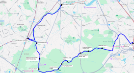
ROUTE: Apologies for the crude crayoning, but here's what the route would look like. Begin at Stop #1, the light rail station at Mattapan Square. Head down Blue Hill Ave, and turn onto Brush Hill Rd. Continue onto Truman Parkway. Turn right onto Neponset River Parkway, turn right onto Hyde Park Ave, and make Stop #2, Readville Station. Turn around at the station, and go back up Hyde Park Ave. Bear left onto Neponset Valley Parkway. Across the river, turn right onto Brush Hill Road. After turning, make Stop #3: Fowl Meadow. Continue onto Brush Hill Rd, then bear right onto Blue Hill Ave. Continue onto Canton Ave, and make Stop #4, Trailside Museum / Great Blue Hill. Continue heading south on Washington St, and make Stop #5, Skyline Trail West. Turn left onto Blue Hill River Road. Continue onto Hillside St and make Stop #6, Houghton's Pond. Continue on Hillside St and make Stop #7, Skyline Trail Central. Bear right to stay on Hillside St, then bear right to turn onto Chickatawbut Rd. Make Stop #8, Dark Hollow Path. Continue east on Chickatawbut Rd. Cross over Randolph Ave and make Stop #9, Chickatawbut Hill Base / Brockton Bus. Continue east on Chickatawbut Rd and make Stop #10, Chickatawbut Overlook. Continue east on Chickatawbut Rd and pass the reservoir. Make Stop #11, Skyline Trail East. Continue on Chickatawbut Rd, then turn left onto Willard St. Follow Willard St, than bear right onto West St. Go under I-93 and then turn right onto Centre St. Follow Centre St, then turn left onto Burgin Parkway. Turn right and make Stop #12, Quincy Adams Station.
Massachusetts already runs several seasonal transit services focused on recreation. The Boston-Salem Ferry. The Boston Harbor Island Ferries. And of course, Cape Flyer. This would be a less expensive (though not inexpensive) option to improve access to nature and improve health and wellness. How does it look?
LENGTH: 14.5 miles
STOPS:
#1 - Mattapan Station
#2 - Readville Station
#3 - Fowl Meadow
#4 - Trailside Museum / Great Blue Hill
#5 - Skyline Trail West
#6 - Houghton's Pond
#7 - Skyline Trail Central
#8 - Dark Hollow Path
#9 - Chickatawbut Hill Base / Brockton Bus
#10 - Chickatawbut Hill Overlook
#11 - Skyline Trail East
#12 - Quincy Adams Station
TRIP TIME: Not quite sure how to estimate this, as I am definitely not an engineer. Google estimates the drive time to be 37 minutes for the entire route. But you would need to add in dwell time, and probably assume that only some of the stops are needed for a given run. So maybe 47 minutes?
RAIL TRANSIT CONNECTIONS (5): Mattapan Line, Fairmount Line, Franklin/Foxborough Line, Providence/Stoughton Line, Red Line.
BUS TRANSIT CONNECTIONS (12): MBTA buses 15, 24, 28, 29, 30, 31, 32, 33, 238, 240, 245, BAT bus 12.
ROUTE: Apologies for the crude crayoning, but here's what the route would look like. Begin at Stop #1, the light rail station at Mattapan Square. Head down Blue Hill Ave, and turn onto Brush Hill Rd. Continue onto Truman Parkway. Turn right onto Neponset River Parkway, turn right onto Hyde Park Ave, and make Stop #2, Readville Station. Turn around at the station, and go back up Hyde Park Ave. Bear left onto Neponset Valley Parkway. Across the river, turn right onto Brush Hill Road. After turning, make Stop #3: Fowl Meadow. Continue onto Brush Hill Rd, then bear right onto Blue Hill Ave. Continue onto Canton Ave, and make Stop #4, Trailside Museum / Great Blue Hill. Continue heading south on Washington St, and make Stop #5, Skyline Trail West. Turn left onto Blue Hill River Road. Continue onto Hillside St and make Stop #6, Houghton's Pond. Continue on Hillside St and make Stop #7, Skyline Trail Central. Bear right to stay on Hillside St, then bear right to turn onto Chickatawbut Rd. Make Stop #8, Dark Hollow Path. Continue east on Chickatawbut Rd. Cross over Randolph Ave and make Stop #9, Chickatawbut Hill Base / Brockton Bus. Continue east on Chickatawbut Rd and make Stop #10, Chickatawbut Overlook. Continue east on Chickatawbut Rd and pass the reservoir. Make Stop #11, Skyline Trail East. Continue on Chickatawbut Rd, then turn left onto Willard St. Follow Willard St, than bear right onto West St. Go under I-93 and then turn right onto Centre St. Follow Centre St, then turn left onto Burgin Parkway. Turn right and make Stop #12, Quincy Adams Station.
Massachusetts already runs several seasonal transit services focused on recreation. The Boston-Salem Ferry. The Boston Harbor Island Ferries. And of course, Cape Flyer. This would be a less expensive (though not inexpensive) option to improve access to nature and improve health and wellness. How does it look?
Attachments
Last edited:
TheRatmeister
Senior Member
- Joined
- Sep 23, 2023
- Messages
- 1,580
- Reaction score
- 3,203
The only change I would propose would be to possibly just cut the route short at Readville, but this would probably be contingent on Readville moving from Zone 2 into Zone 1A.So my pitch is for a new seasonal transit service that would make it easier for people in the Boston area to swim, hike, and fish without needing a car: the Blue Hills Explorer! It would be a bus or shuttle service that operates half of the year (May-October). You would run a handful of vehicles so you can get 20 minute headways 8am-6pm or so, on Saturdays, Sundays, and holidays. This would be an express service, which would make stops only within the Blue Hills Reservation, and at transit stops where people can make transfers from other services. It would be a unique option, as far as I can tell, with several stops right at trailheads. It takes advantage of the 7,000 beautiful acres of the Blue Hills and spreads people out amongst various trails and destinations within the park. It also connects the low-income neighborhoods of Mattapan and Hyde Park to outdoor recreational activities that require a car to get to today. (The MBTA 716 bus is a joke, that only goes to Trailside Museum in the park and doesn't even run on Sundays).
LENGTH: 14.5 miles
STOPS:
#1 - Mattapan Station
#2 - Readville Station
#3 - Fowl Meadow
#4 - Trailside Museum / Great Blue Hill
#5 - Skyline Trail West
#6 - Houghton's Pond
#7 - Skyline Trail Central
#8 - Dark Hollow Path
#9 - Chickatawbut Hill Base / Brockton Bus
#10 - Chickatawbut Hill Overlook
#11 - Skyline Trail East
#12 - Quincy Adams Station
TRIP TIME: Not quite sure how to estimate this, as I am definitely not an engineer. Google estimates the drive time to be 37 minutes for the entire route. But you would need to add in dwell time, and probably assume that only some of the stops are needed for a given run. So maybe 47 minutes?
RAIL TRANSIT CONNECTIONS (5): Mattapan Line, Fairmount Line, Franklin/Foxborough Line, Providence/Stoughton Line, Red Line.
BUS TRANSIT CONNECTIONS (11): MBTA buses 15, 24, 28, 29, 30, 31, 32, 33, 238, 245, BAT bus 12.
ROUTE: Apologies for the crude crayoning, but here's what the route would look like. Begin at Stop #1, the light rail station at Mattapan Square. Head down Blue Hill Ave, and turn onto Brush Hill Rd. Continue onto Truman Parkway. Turn right onto Neponset River Parkway, turn right onto Hyde Park Ave, and make Stop #2, Readville Station. Turn around at the station, and go back up Hyde Park Ave. Bear left onto Neponset Valley Parkway. Across the river, turn right onto Brush Hill Road. After turning, make Stop #3: Fowl Meadow. Continue onto Brush Hill Rd, then bear right onto Blue Hill Ave. Continue onto Canton Ave, and make Stop #4, Trailside Museum / Great Blue Hill. Continue heading south on Washington St, and make Stop #5, Skyline Trail West. Turn left onto Blue Hill River Road. Continue onto Hillside St and make Stop #6, Houghton's Pond. Continue on Hillside St and make Stop #7, Skyline Trail Central. Bear right to stay on Hillside St, then bear right to turn onto Chickatawbut Rd. Make Stop #8, Dark Hollow Path. Continue east on Chickatawbut Rd. Cross over Randolph Ave and make Stop #9, Chickatawbut Hill Base / Brockton Bus. Continue east on Chickatawbut Rd and make Stop #10, Chickatawbut Overlook. Continue east on Chickatawbut Rd and pass the reservoir. Make Stop #11, Skyline Trail East. Continue on Chickatawbut Rd, then turn right onto Granite St. Enter 93N/1N. Get off at Exit 7. Merge onto Burgin Parkway. Turn right and make Stop #12, Quincy Adams Station.
Massachusetts already runs several seasonal transit services focused on recreation. The Boston-Salem Ferry. The Boston Harbor Island Ferries. And of course, Cape Flyer. This would be a less expensive (though not inexpensive) option to improve access to nature and improve health and wellness. How does it look?
Slight change I would recommend is not getting on the highway at the eastern edge and instead follow the 238 routing along west/centre. It wouldn't be a problem for eastbound busses but for westbound ones it would require the bus to merge 4 lanes across the highway in about 0.25 miles. The time difference, at least westbound, is miniscule. Perhaps you can keep the routing as is for eastbound.
Cutting the route at Readville would never survive public process.
You may be interested in this 2022 MPO project, Unlocking the Blue Hills, which recommends bus service alternatives very similar to what you're proposing.
Cutting the route at Readville would never survive public process.
You may be interested in this 2022 MPO project, Unlocking the Blue Hills, which recommends bus service alternatives very similar to what you're proposing.
That looks great. I totally agree we can and should have more public transit for recreation.So my pitch is for a new seasonal transit service that would make it easier for people in the Boston area to swim, hike, and fish without needing a car: the Blue Hills Explorer! It would be a bus or shuttle service that operates half of the year (May-October). You would run a handful of vehicles so you can get 20 minute headways 8am-6pm or so, on Saturdays, Sundays, and holidays. This would be an express service, which would make stops only within the Blue Hills Reservation, and at transit stops where people can make transfers from other services. It would be a unique option, as far as I can tell, with several stops right at trailheads. It takes advantage of the 7,000 beautiful acres of the Blue Hills and spreads people out amongst various trails and destinations within the park. It also connects the low-income neighborhoods of Mattapan and Hyde Park to outdoor recreational activities that require a car to get to today. (The MBTA 716 bus is a joke, that only goes to Trailside Museum in the park and doesn't even run on Sundays).
LENGTH: 14.5 miles
STOPS:
#1 - Mattapan Station
#2 - Readville Station
#3 - Fowl Meadow
#4 - Trailside Museum / Great Blue Hill
#5 - Skyline Trail West
#6 - Houghton's Pond
#7 - Skyline Trail Central
#8 - Dark Hollow Path
#9 - Chickatawbut Hill Base / Brockton Bus
#10 - Chickatawbut Hill Overlook
#11 - Skyline Trail East
#12 - Quincy Adams Station
TRIP TIME: Not quite sure how to estimate this, as I am definitely not an engineer. Google estimates the drive time to be 37 minutes for the entire route. But you would need to add in dwell time, and probably assume that only some of the stops are needed for a given run. So maybe 47 minutes?
RAIL TRANSIT CONNECTIONS (5): Mattapan Line, Fairmount Line, Franklin/Foxborough Line, Providence/Stoughton Line, Red Line.
BUS TRANSIT CONNECTIONS (11): MBTA buses 15, 24, 28, 29, 30, 31, 32, 33, 238, 245, BAT bus 12.
ROUTE: Apologies for the crude crayoning, but here's what the route would look like. Begin at Stop #1, the light rail station at Mattapan Square. Head down Blue Hill Ave, and turn onto Brush Hill Rd. Continue onto Truman Parkway. Turn right onto Neponset River Parkway, turn right onto Hyde Park Ave, and make Stop #2, Readville Station. Turn around at the station, and go back up Hyde Park Ave. Bear left onto Neponset Valley Parkway. Across the river, turn right onto Brush Hill Road. After turning, make Stop #3: Fowl Meadow. Continue onto Brush Hill Rd, then bear right onto Blue Hill Ave. Continue onto Canton Ave, and make Stop #4, Trailside Museum / Great Blue Hill. Continue heading south on Washington St, and make Stop #5, Skyline Trail West. Turn left onto Blue Hill River Road. Continue onto Hillside St and make Stop #6, Houghton's Pond. Continue on Hillside St and make Stop #7, Skyline Trail Central. Bear right to stay on Hillside St, then bear right to turn onto Chickatawbut Rd. Make Stop #8, Dark Hollow Path. Continue east on Chickatawbut Rd. Cross over Randolph Ave and make Stop #9, Chickatawbut Hill Base / Brockton Bus. Continue east on Chickatawbut Rd and make Stop #10, Chickatawbut Overlook. Continue east on Chickatawbut Rd and pass the reservoir. Make Stop #11, Skyline Trail East. Continue on Chickatawbut Rd, then turn right onto Granite St. Enter 93N/1N. Get off at Exit 7. Merge onto Burgin Parkway. Turn right and make Stop #12, Quincy Adams Station.
Massachusetts already runs several seasonal transit services focused on recreation. The Boston-Salem Ferry. The Boston Harbor Island Ferries. And of course, Cape Flyer. This would be a less expensive (though not inexpensive) option to improve access to nature and improve health and wellness. How does it look?
A few scattered thoughts:
- I've been in the Blue Hills quite a few times where car traffic even in the park is bad, especially around Houghton's Pond. There are a lot of cars; drivers slow down looking for parking; people park on the side of the road near a trailhead, but not quite far enough to the side, etc. On popular days, there's no way the bus will run that route in 47 minutes. I have no solution for you, here. (But it is wild the kind of traffic cars can create, even in the woods.)
- You missed the MBTA #240 bus, which stops at your stop number nine. There's a trailhead there, and the bus runs on weekends. I'd much prefer the more frequent service you planned, but just mentioning in case anyone wanted to get down there.
- I was recently reminded of Metro North's Appalachian Trail train stop in New York, and thinking about that kind of thing for Massachusetts. I'd love to hear anyone else's suggestions for improving car-free access to the outdoors, or if anyone has suggestions for existing trips already accessible by public transit. With the T slow zones getting cleared, it's probably finally pleasant enough to get to Middlesex Fells at Oak Grove on the Orange Line....
EastCambridgeDreamer
New member
- Joined
- Sep 17, 2024
- Messages
- 23
- Reaction score
- 34
Thanks for the good ideas! I updated the route to use the 238 path east of the park, and added the 240 bus to the list of connections.
Agreed on Mattapan. It makes the route significantly longer but it's worth it to connect that underserved neighborhood to the Blue Hills. And I actually did read the 2022 MPO project, it was thoughtul but I thought it focused too much on budget. A transit service is either worth making frequent enough to meet the need, or it probably shouldn't be built out to begin with.
As for the Appalachian Trail stop on the Amtrak, that is really neat. I'm a marketer by trade and ideally, I think it's worthwhile to try to encourage people to visit outdoor areas that are quiet today so spread people out and reduce the environmental impact. But getting people to try visiting a new area likely takes investment to build out some basic infrastructure before considering transit service. Other than the Blue Hills, are there other outdoor areas around New England that are either well established already and could use recreational transit? Or areas that have potential to be built out into recreational areas? The only other one I know of would be Walden's Pond, which had a train station a very long time ago. However, the beach there is tiny and the wealthy locals would never agree to the CR stopping at the pond.
Slight change I would recommend is not getting on the highway at the eastern edge and instead follow the 238 routing along west/centre. It wouldn't be a problem for eastbound busses but for westbound ones it would require the bus to merge 4 lanes across the highway in about 0.25 miles. The time difference, at least westbound, is miniscule. Perhaps you can keep the routing as is for eastbound.
Cutting the route at Readville would never survive public process.
You may be interested in this 2022 MPO project, Unlocking the Blue Hills, which recommends bus service alternatives very similar to what you're proposing.
Agreed on Mattapan. It makes the route significantly longer but it's worth it to connect that underserved neighborhood to the Blue Hills. And I actually did read the 2022 MPO project, it was thoughtul but I thought it focused too much on budget. A transit service is either worth making frequent enough to meet the need, or it probably shouldn't be built out to begin with.
Yeah the traffic is a good point but I don't see a good way around it either.That looks great. I totally agree we can and should have more public transit for recreation.
A few scattered thoughts:
- I've been in the Blue Hills quite a few times where car traffic even in the park is bad, especially around Houghton's Pond. There are a lot of cars; drivers slow down looking for parking; people park on the side of the road near a trailhead, but not quite far enough to the side, etc. On popular days, there's no way the bus will run that route in 47 minutes. I have no solution for you, here. (But it is wild the kind of traffic cars can create, even in the woods.)
- You missed the MBTA #240 bus, which stops at your stop number nine. There's a trailhead there, and the bus runs on weekends. I'd much prefer the more frequent service you planned, but just mentioning in case anyone wanted to get down there.
- I was recently reminded of Metro North's Appalachian Trail train stop in New York, and thinking about that kind of thing for Massachusetts. I'd love to hear anyone else's suggestions for improving car-free access to the outdoors, or if anyone has suggestions for existing trips already accessible by public transit. With the T slow zones getting cleared, it's probably finally pleasant enough to get to Middlesex Fells at Oak Grove on the Orange Line....
As for the Appalachian Trail stop on the Amtrak, that is really neat. I'm a marketer by trade and ideally, I think it's worthwhile to try to encourage people to visit outdoor areas that are quiet today so spread people out and reduce the environmental impact. But getting people to try visiting a new area likely takes investment to build out some basic infrastructure before considering transit service. Other than the Blue Hills, are there other outdoor areas around New England that are either well established already and could use recreational transit? Or areas that have potential to be built out into recreational areas? The only other one I know of would be Walden's Pond, which had a train station a very long time ago. However, the beach there is tiny and the wealthy locals would never agree to the CR stopping at the pond.
Have people given thought to restoring commuter rail service on the minuteman out to Bedford? Even just a single-track line. It seems like a good response if the Alewife area is redeveloped with less on-site parking. That project would be a good opportunity to connect a minuteman CR line with the Fitchburg line as the roads around Alewife would be getting reconfigured anyway. This extension and the bike path could probably both fit in the ROW - the only place where you run into trouble is the narrow bridge over 128 which would have to be rebuilt. Overall this project would be quicker and cheaper than an RLX, which could happen later and wouldn’t have to go all the way to 128.
RandomWalk
Senior Member
- Joined
- Feb 2, 2014
- Messages
- 3,837
- Reaction score
- 6,976
A couple of points:
- Restoring the grade crossing in Arlington Center would not be popular with the locals.
- Most of the bridges have been rebuilt to be bike path only, even if the abutments still have space for two tracks.
- Bike path users and abutters would react violently to the prospect of riding/walking/living next to an active rail line.
The Arlington Center grade crossing would definitely need to be eliminated but the tunnel would still be fairly short. Even with this and the bridges requiring modification, the changes you need to make are less extensive than a cut-and-cover RLX.
The user experience of the minuteman would change, but it would still retain its functionality. The combination of path and trail would be similar to the western end of the Fitchburg Cutoff or what’s being planned for the Belmont Community Path. Any underground rail would cost too much and probably wouldn’t fit the time frame of what’s happening at Alewife. You can decrease the noise/disruption by using the light rail dinky described somewhere in the RLX thread but then you have to transfer at Alewife. I feel like having a one-seat connection to downtown would be important for commuters.
The user experience of the minuteman would change, but it would still retain its functionality. The combination of path and trail would be similar to the western end of the Fitchburg Cutoff or what’s being planned for the Belmont Community Path. Any underground rail would cost too much and probably wouldn’t fit the time frame of what’s happening at Alewife. You can decrease the noise/disruption by using the light rail dinky described somewhere in the RLX thread but then you have to transfer at Alewife. I feel like having a one-seat connection to downtown would be important for commuters.
TheRatmeister
Senior Member
- Joined
- Sep 23, 2023
- Messages
- 1,580
- Reaction score
- 3,203
People have no problem using the Neponset trail, but you're right that abutters would likely not be happy.Bike path users and abutters would react violently to the prospect of riding/walking/living next to an active rail line.
Arlington Center is probably more than half the cost of RLX to Arlington Heights. If you're doing that part it makes sense to just do the rest too, and then start from Arlington Heights for a dinky to Bedford.The Arlington Center grade crossing would definitely need to be eliminated but the tunnel would still be fairly short. Even with this and the bridges requiring modification, the changes you need to make are less extensive than a cut-and-cover RLX.
When thinking about the overnight service question before I made this rough routing in Google Earth with the goal of orienting routes to converge on areas of high night employment, hospitals, clubs, etc, and trying to have the Boston area's population center neighborhoods within a 20min walk of a route, so not Newton, Arlington, Belmont, etc to keep the number of routes minimal. https://www.google.com/maps/d/u/0/viewer?mid=1pLh08flhWsTuNAcgw-nvVMyvinRCaxU&ll=42.3740074204291,-71.05674450000001&z=12
Apparently I've been sleeping on this thread for several months. These are both really cool ideas!So my pitch is for a new seasonal transit service that would make it easier for people in the Boston area to swim, hike, and fish without needing a car: the Blue Hills Explorer!