You are using an out of date browser. It may not display this or other websites correctly.
You should upgrade or use an alternative browser.
You should upgrade or use an alternative browser.
Rose Kennedy Greenway
- Thread starter callahan
- Start date
bigpicture7
Senior Member
- Joined
- May 5, 2016
- Messages
- 4,068
- Reaction score
- 10,551
Wow....so off topic...delete asap.?....
HA!
Nah, I think Data knows that we need to lighten up a bit and take ourselves a bit less seriously on here sometimes. In that case, highly on topic.
Happy Friday.
whighlander
Senior Member
- Joined
- Aug 14, 2006
- Messages
- 7,812
- Reaction score
- 647
^I'm going to assume you are unaware there is a highway running directly under the greenway. You should look into it. Have you heard of Wikipedia? There's probably something on there.
Justin -- I'm going to assume that when you hear the phrase "Green Monster" you think only of drinking beer 30+ feet above the Left Field in Fenway
If you knew what it was like to be where the Chinese Zodiac Heads are located circa 1990 -- we wouldn't be having this discussion
The only Good Feature of the old Green Monster was there was a pedestrian bridge passing above the tumultuous motorized chaos as it began to descend into the South Station Tunnel -- Great location for pictures of the Central Artery up-close and impersonal
A few photos from different eras to refresh your memory


bigpicture7
Senior Member
- Joined
- May 5, 2016
- Messages
- 4,068
- Reaction score
- 10,551
I think the point being made was that putting the elevated highway underground should have eliminated the need for the surface-level highway we currently have.
Along these lines, I think it's a slight travesty that Atlantic Ave is such a zoo despite all the effort to put the highway underground. The pedestrian crossing between the greenway and long wharf is particularly bad.
whighlander
Senior Member
- Joined
- Aug 14, 2006
- Messages
- 7,812
- Reaction score
- 647
I think the point being made was that putting the elevated highway underground should have eliminated the need for the surface-level highway we currently have.
Statler -- that's precisely the wrong conclusion -- even as early as the mid 1950's the planners realized that in addition to the highway heading into the "Chinatown underpass" [later to be known as the South station Tunnel] that there needed to be about 6 lanes on the surface
If you look at one more photo you will see why -- the approach from the South looks like an LA complex of highway lanes [about 16 depending on how you count them as ramps weave to and fro and in and out] -- that total volume of traffic splits in and around the South Bay / Fort Point Channel Interchange with essentially half of it heading underneath in the Big Dig
Some of it goes across the harbor to Logan and some goes west on the Pike -- but there are still a lot of cars that need to be accommodated by the Greenway whose desitination is inside the core of the city

whighlander
Senior Member
- Joined
- Aug 14, 2006
- Messages
- 7,812
- Reaction score
- 647
Along these lines, I think it's a slight travesty that Atlantic Ave is such a zoo despite all the effort to put the highway underground. The pedestrian crossing between the greenway and long wharf is particularly bad.
BigPicture -- you need a new nom-de-Post
The Big Picture is that Atlantic Ave has been a major thoroughfare since it was laid out in the late 19th C.
it has carried cars, trucks, horse drawn vehicles, the El and even rail freight -- and it still has to carry its burden -- get over it

The Atlantic Avenue Elevated railway near Rowe's Wharf, looking north, July 21, 1932 [photo © Leslie Jones via BPL Digital Commonwealth Project]
stellarfun
Senior Member
- Joined
- Dec 28, 2006
- Messages
- 5,726
- Reaction score
- 1,586
Regarding the photograph. Is the street to the left of the station High st., or Broad St.?
I thought the next wharf up from Rowe's wharf was Bulfinch's India Wharf, but Savooran was at 28-31 India Wharf. So that sign marks India Wharf.
I thought the next wharf up from Rowe's wharf was Bulfinch's India Wharf, but Savooran was at 28-31 India Wharf. So that sign marks India Wharf.
bigpicture7
Senior Member
- Joined
- May 5, 2016
- Messages
- 4,068
- Reaction score
- 10,551
BigPicture -- you need a new nom-de-Post
The Big Picture is that Atlantic Ave has been a major thoroughfare since it was laid out in the late 19th C.
it has carried cars, trucks, horse drawn vehicles, the El and even rail freight -- and it still has to carry its burden -- get over it
Whigh, I respect and admire the history. And appreciate the photos very much. But IMHO, the big picture is that what it was, what it is, and what it can be need not be the same. Cities are allowed to evolve. And as I've said in previous posts, we should be grateful that the greenway is as good as it is; I agree a bit of pragmatism is appropriate.
whighlander
Senior Member
- Joined
- Aug 14, 2006
- Messages
- 7,812
- Reaction score
- 647
Whigh, I respect and admire the history. And appreciate the photos very much. But IMHO, the big picture is that what it was, what it is, and what it can be need not be the same. Cities are allowed to evolve. And as I've said in previous posts, we should be grateful that the greenway is as good as it is; I agree a bit of pragmatism is appropriate.
BigPicture -- Yes of course -- change is the only constant in the Universe
My point is that the Greenway as a hybrid of a major transportation chanel and a major recreational destination is better than Good
Yes it could be better and it probably will get better -- but it is a success and we should celebrate it and embrace it as such
whighlander
Senior Member
- Joined
- Aug 14, 2006
- Messages
- 7,812
- Reaction score
- 647
Regarding the photograph. Is the street to the left of the station High st., or Broad St.?
I thought the next wharf up from Rowe's wharf was Bulfinch's India Wharf, but Savooran was at 28-31 India Wharf. So that sign marks India Wharf.
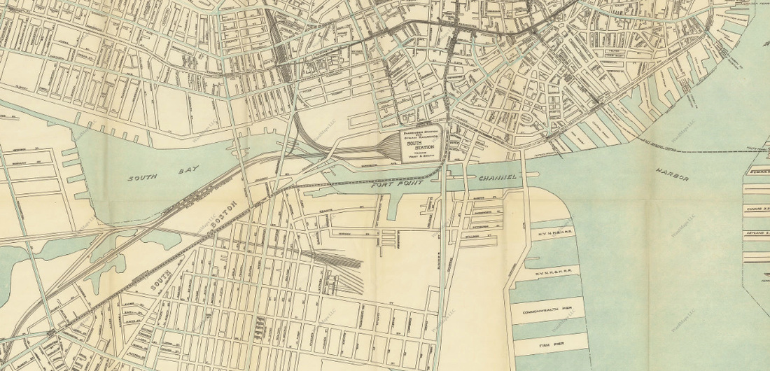
Stellar -- I found this on the Wiki about the Atlantic Ave El -- the underlying map is a bit difficult to read

I looked at a Map from 1899 that the BPL has online
Boston
further review of several other maps
Purchase St cuts across Oliver and ends at Broad in a strange [Boston-style] intersection which also includes High Street -- Broad then continues essentially a short block to end at Atlantic Ave just opposite Rowes Wharf
Author: Downs, A. E. (Albert E.)
Publisher: Downs, A. E. (Albert E.)
Date: 1899
Location: Boston (Mass.)
Dimensions: 55.0 x 96.0 cm.
Scale: Not drawn to scale
Call Number: G3764.B6A3 1899 .D6
The Leventhal Map collection at the BPL
and its on-line access is one of Boston's hidden treasures
with an amazing interactive viewer you can zoom down to individual lots
http://maps.bpl.org/id/11180
India St. -- connects to India Wharf
Broad St. essentially ends at Atlantic in between Rowes and Foster's Wharfs
Oliver St. is the next street to the left
Map of Boston proper
Author: Geo. H. Walker & Co.
Publisher: Geo. H. Walker & Co.
Date: 1894
Better sense of what happens by the end of Broad St.
Purchase St. cuts across Oliver St joins High and both end at a Boston-style intersection with Broad St. one short block from where Broad hits Atlantic
here are a couple of very small almost aley streets connecting between Purchase and Atlantic between the Intersections of Oliver and Broad
see
http://maps.bpl.org/id/10111
and one from the Boston Transit Comission circa 1913
Last edited:
stellarfun
Senior Member
- Joined
- Dec 28, 2006
- Messages
- 5,726
- Reaction score
- 1,586
whigh,
The street opposite the Rowes Wharf station is almost certainly High St. The map of the elevated you posted shows a small circle of a street, which I believe to be Fort Hill, where IP is now.

^^^Map from 1899; at the extreme left of the map, the building at the NW corner of Atlantic Ave and High St. , with the curved facade at the corner, is depicted.
Atlantic Ave, before motorized vehicles, was at least two lanes in each direction, with one or two streetcar tracks in the middle. I daresay, at the time, there were probably few Boston streets that were wider.
The street opposite the Rowes Wharf station is almost certainly High St. The map of the elevated you posted shows a small circle of a street, which I believe to be Fort Hill, where IP is now.
^^^Map from 1899; at the extreme left of the map, the building at the NW corner of Atlantic Ave and High St. , with the curved facade at the corner, is depicted.
Atlantic Ave, before motorized vehicles, was at least two lanes in each direction, with one or two streetcar tracks in the middle. I daresay, at the time, there were probably few Boston streets that were wider.
J
Justin7
Guest
The greenway first and foremost was a concession to get the cat project signed off on. Having a park downtown is beneficial in one way and reconnecting long disconnected roads is beneficial in another. Both need to happen, and do. You can find negatives in everything if you look for them. Just appreciate it for what it is and how much better it makes downtown.
I disagree. Simply because something is better than it was doesn't mean we should ignore its current faults. It can and should be improved.
TheRifleman
Banned
- Joined
- Sep 25, 2008
- Messages
- 4,431
- Reaction score
- 0
Greenway Parcel in front of IP-RowesWharf---Does the Conservancy plan to do anything with that parcel?
Like build a platform on top or sometype of structure. I remember there was a proposal for something but the Greenway did not have the funds to build it.
This is one of the parcels that needs a lot of help: Very uninviting--Desolate.
I took a walk through the Greenway last night: I have to say the Park was very quite after 9PM.
A couple of alcoholics playing music outside of 7-eleven at Harbor Garage looking for Beer money. Great vibe.
Boston better get something going because when this Casino is built in Everett we are about to see the Nightlife completely shift to Everett. Boston could lose a good percentage if Wynn does this right.
Everett could be open 24 hour night life.
whighlander
Senior Member
- Joined
- Aug 14, 2006
- Messages
- 7,812
- Reaction score
- 647
whigh,
The street opposite the Rowes Wharf station is almost certainly High St. The map of the elevated you posted shows a small circle of a street, which I believe to be Fort Hill, where IP is now.
^^^Map from 1899; at the extreme left of the map, the building at the NW corner of Atlantic Ave and High St. , with the curved facade at the corner, is depicted.
Atlantic Ave, before motorized vehicles, was at least two lanes in each direction, with one or two streetcar tracks in the middle. I daresay, at the time, there were probably few Boston streets that were wider.
Stellar -- I looked at 4 or 5 maps on the web in response to your earlier question
St the time of the Atlantic Ave El's construction and before the Mollases Flood
High Street did not connect directly to Atlantic
High looped around what was an open area "Fort Hill Square circa 1870 and connected with Broad and Purchase
Atlantic was added circa 1880 and the El came right after the street
I also consulted two maps that I have hanging on my walls in my mini-Leventhal [more like micro] -- one was a map showing where the fire had burned and another was somewhat later
In the first there is No Atlantic Ave until after Rowes Wharf -- there was just Broad Street which ran north-ish and then turned inward about at Rowes where Atlantic began. High and Oliver essentially intersected perpendicularly to Broad which was essentially 1 block closer to the water than a nearly parallel Purchase St. At that time Atlantic cut across some of the wharfs to the extent that water was on both sides at Central.
The second map is somewhat later there is no water on the city side of Atlantic and the part of Broad which ran along the shore has become Atlantic -- this map is from before 1910 as there is no Charles River Dam or Esplanade although there is the Olmstead "Charlesbsnk" where Lederman Park is located today -- so its post 1890
odurandina
Senior Member
- Joined
- Dec 1, 2015
- Messages
- 5,328
- Reaction score
- 266
I disagree. Simply because something is better than it was doesn't mean we should ignore its current faults. It can and should be improved.
Yup, i was a bit surprised by the rather scant dimensions of the some of the Greenway's green patches. Could that be improved? Could a few pedestrian bridges be added? I don't see how any improvements would be dramatic. Srsly, looking back at the daunting dimensions of the Big Dig, i am truly grateful we have what we have.
Looking at the right of way and cross streets makes me think of the old CA as a permanent blight, and detour - with the balance now restored. Current projects finishing up and upcoming digs at GCG, GG, (and likely, eventual redo's of JFK office park, City Hall and HG) will surely bring the smooth traffic pattern you currently enjoy to it's sad end.
stellarfun
Senior Member
- Joined
- Dec 28, 2006
- Messages
- 5,726
- Reaction score
- 1,586
Belaboring the point,
* The Atlantic Avenue Elevated was built at the start of the Twentieth Century; the map I posted is dated 1899.
* The 1896 Directory of Boston streets (which I saved from my days driving a hackney carriage) lists High St as extending from 128 Summer St. to Broad St.
* Atlantic Ave went from the junction of Commercial st and Eastern Ave to Federal St.
* Broad St went from 133 State to 333 Atlantic.
--------------
* Before Atlantic Ave, Broad St went from 133 State to Federal St at the junction of Summer. (It was called Broad St. for a reason.)
** 81 Broad was the corner of Batterymarch.
** 107 Broad was Half-moon Place (also listed as 123 Broad)
** 120 Broad was India Wharf
** 144 Broad was Rowe's Wharf
** 165 Broad was Purchase St.
Half-moon Place was created by excavating into the side of Fort hill. One accessed Half-moon Place either from [old] Broad St., or via Jacob's Ladder, which connected Half-moon to Humphrey Place. Humphrey Place was one side of Hamilton St. Hamilton St. ran between Batterymarch and Washington Sq. Washington Sq circled the 'peak' of Fort hill.
--------------------------
India Wharf burning June 1952
http://bostonfirehistory.org/wp-content/uploads/sites/51/2016/07/photofireindiawharf06101952-2.pdf
Burning again, 1955
http://bostonfirehistory.org/wp-content/uploads/sites/51/2016/07/photofireindiawharf03031955.pdf
Union Wharf burning in 1952
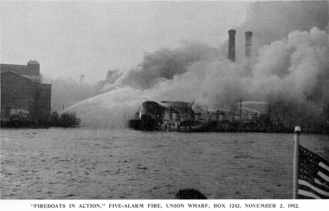
http://northendwaterfront.com/2014/11/remembering-the-november-2-1952-union-wharf-fire/
A reason why Union Wharf was salvaged, and India Wharf became a parking lot is the difference between granite and brick.
* The Atlantic Avenue Elevated was built at the start of the Twentieth Century; the map I posted is dated 1899.
* The 1896 Directory of Boston streets (which I saved from my days driving a hackney carriage) lists High St as extending from 128 Summer St. to Broad St.
* Atlantic Ave went from the junction of Commercial st and Eastern Ave to Federal St.
* Broad St went from 133 State to 333 Atlantic.
--------------
* Before Atlantic Ave, Broad St went from 133 State to Federal St at the junction of Summer. (It was called Broad St. for a reason.)
** 81 Broad was the corner of Batterymarch.
** 107 Broad was Half-moon Place (also listed as 123 Broad)
** 120 Broad was India Wharf
** 144 Broad was Rowe's Wharf
** 165 Broad was Purchase St.
Half-moon Place was created by excavating into the side of Fort hill. One accessed Half-moon Place either from [old] Broad St., or via Jacob's Ladder, which connected Half-moon to Humphrey Place. Humphrey Place was one side of Hamilton St. Hamilton St. ran between Batterymarch and Washington Sq. Washington Sq circled the 'peak' of Fort hill.
--------------------------
India Wharf burning June 1952
http://bostonfirehistory.org/wp-content/uploads/sites/51/2016/07/photofireindiawharf06101952-2.pdf
Burning again, 1955
http://bostonfirehistory.org/wp-content/uploads/sites/51/2016/07/photofireindiawharf03031955.pdf
Union Wharf burning in 1952
http://northendwaterfront.com/2014/11/remembering-the-november-2-1952-union-wharf-fire/
A reason why Union Wharf was salvaged, and India Wharf became a parking lot is the difference between granite and brick.
Last edited:
odurandina
Senior Member
- Joined
- Dec 1, 2015
- Messages
- 5,328
- Reaction score
- 266
...the approach from the South looks like an LA complex of highway lanes....
as someone who logs several k miles on LA freeways every winter, i'm still amazed how little time i actually spend in actual traffic snarls.... believe it or not.... Just avoid the 10, Santa Ana, Golden State, 91 and San Diego frwy's as much as possible, and you're home!! The rest is a cakewalk! and remember, if you're going on the Hollywood Frwy (aka 101) leave a few minutes early.... and when you really gotta get there, the 60, 57, 110, 210, 605 and 710 are your friend/s!
statler
Senior Member
- Joined
- May 25, 2006
- Messages
- 7,944
- Reaction score
- 562
Just avoid the 10, Santa Ana, Golden State, 91 and San Diego frwy's as much as possible, and you're home!! The rest is a cakewalk! and remember, if you're going on the Hollywood Frwy (aka 101) leave a few minutes early.... and when you really gotta get there, the 60, 57, 110, 210, 605 and 710 are your friend/s!
Is there an archLA? I imagine that every thread would just be full of this...
Edited by Mod