Rose Kennedy Greenway

I actually agree with Kressel here, that we are creating way too much bureaucracy for a crappy park. Starve the money, and hopefully people will see how crappy the park really is and people might actually want buildings (not many people know that much about urban design, so of course just a fantasy).
 
How Shirley Kressel get's so much press when she's clearly off her medication is always amazing to me. Is there a meeting somewhere that she doesn't attend and raise a fuss? She even gets her figures wrong...probably done to enhance her own argument. The RKG is about 15 acres of parkland which figures out to be about $360K per acre of this 10 million annually, not the 1 million per acre she quotes in the paper. It's really too bad that the reporter didn't check on the facts before publishing her very inflated figures as to the cost per acre. The Rose Kennedy Greenway is located in Boston, the capital city of Massachusetts and therefore should be partly funded by the state. This is a good thing and I hope it passes.
 
hopefully people will see how crappy the park really is and people might actually want buildings

People here assume that replacing the highway with buildings would have produced a better outcome than replacing it with parks. Everyone just assumes that but never bother to give reasons why it would be the case. In fact the most likely result would be something like Penn Center in Philadelphia or Embarcadero Center in San Francisco. Neither is a credit to their cities or something to be emulated. On the other hand it's just possible the Greenway may be proving something of an inspiration to others....

AtlantaGreenLine1.jpg


AtlantaGreenLine2.jpg


AtlantaGreenLine3.jpg


AtlantaGreenLine4.jpg
 
The number of acres may depend on whether you count the three ramp parcels, and also the Mass. Hort parcels.
 
The Atlanta proposal reminds me of our South End park covering the failed Southwest Expressway.
 
I love how Atlanta proposes a Greenway lined by purpose-built structures and even the rendering looks worse than the RKG.
 
The number of acres may depend on whether you count the three ramp parcels, and also the Mass. Hort parcels.

Shirley shrunk the Greenway to be just the Wharf District Park. That is about five acres. Is she elitist? As for the rest of the Greenway, thats for immigrants or the children of immigrants. Some of them even speak languages she doesn't understand.

For a profile of Shirley:

http://www.boston.com/news/local/massachusetts/articles/2004/10/24/city_hall_tilter?pg=full
 
This park is crime central for the Back Bay and the South End.

I'm surprised to hear this, because the part from Back Bay to Mass Ave station is quite attractive and always seems to be full of dog walkers. The Jamaica Plain section is also quite nice. The middle, between about Northampton Street and Jackson Square, has always seemed to me quite poorly planned and executed.
 
This park is crime central for the Back Bay and the South End. The State police have responsibility here.

My uncle lives on Claremont and has never had any problems. I walk from his apt. to the North End all the time very late at night and have never had any problems. What sort of crimes are you speaking of? It's a great area, full of kids and families.
 
I've heard for years that Corridor Park is dangerous and the Boston Courant mentioned this about two weeks ago. They were quoting the police
 
This is as good a place as any for me to mention I was over in East Boston today and the Bremen Street Greenway is just fantastic. Very attractive, broken up into squares of space, each with its own purpose. Open park land, plenty of seats, a community garden, a big huge kids playground, and next to it ... a new YMCA. Plus, convenient access to the subway.

It's a beauty.

For more information, check out the Boston Harborwalks website:

http://www.bostonharborwalk.com/placestogo/location.php?nid=4&sid=25
 
Was the intent of that little Greenway to make Eastie look rural? If so, I think they succeeded beyond their wildest dreams.
 
czsz said:
Was the intent of that little Greenway to make Eastie look rural?

Orient Heights kinda was once. My grandfather moved the family here in 1936. At that time, the area above Waldemar Ave, and much of the Suffolk Downs parking lot were farmland. Olmsted's Wood Island Park was a popular destination for thousands of working class families. Many of the area brown-fields, parking lots, and tank farms (like what you see along Rt. 1A) were marshlands. I've seen an aerial photo form the '30's (part of the Athen?um collection) of an naval airship flying over what is now 1A; just about everything from the Chelsea Creek to Saratoga Street is open fields.
 
Was the intent of that little Greenway to make Eastie look rural? If so, I think they succeeded beyond their wildest dreams.

I think the intent was to provide parkspace for an area of Eastie that doesn't have any (between Maverick and Day Square), but has a lot more children than any other similarly dense neighborhood in the city. What would you suggest? The way I see it, you could either use this land for airport-related commercial development (which is what is was before), or for parkspace that's desperately needed in this community. I abhor Shirley Kressel inspired open space as much as the next guy, but well designed parkspace like Bremen Street is put to good use in neighborhoods like this. This isn't a strip of grass in the Seaport or along office towers on the Greenway.
 
^ Indeed -- the new Y began it's life as a car-barn for the trolleys that were the ancestors of the Blue Line.
 
Safdie fired as architect of the proposed Boston Museum. I guess the new shape will be nothing like the old.


1205911375_8030.gif

Boston Museum seeks new site

Group: Ramps make building on Greenway parcel too costly

By Thomas C. Palmer Jr., Globe Staff | March 19, 2008

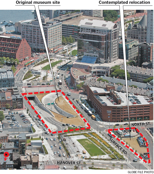
The Boston Museum Project wants to build on an alternate site on the Rose Fitzgerald Kennedy Greenway after determining it is too expensive and difficult to locate on its designated block, which has two highway ramps.

The new site would be off the main strip of parks, west across Surface Road toward Haymarket, but still within the boundaries of the Greenway. Though smaller in size, the site is not broken up by highway infrastructure.
One construction professional estimated that it would cost $15 million more to build on a parcel with highway ramps on it.

"I have been trying to create a more feasible project . . . to make this project much more conducive to a better city and Greenway and project," said Frank Keefe, the chief executive of the Boston Museum Project.

Keefe would not elaborate on the group's plans.But he confirmed that museum officials have abandoned the provocativedesign of high-profile architect Moshe Safdie of Somerville, a glass-enclosed structure that looked like a whale carcass or the ribs of a great ship.

"They fired us," Safdie said yesterday in a phone interview from Jerusalem, where he has a home. "The new person leading this, Frank Keefe, wanted his own team, and he dumped us."

Safdie said his firm had worked with the Boston Museum Project for more than two years "almost for nothing" and was still owed for its work. A museum project executive, who asked not to be identified, said Safdie had been paid in full for his work with a check for $173,000.

"A new site, a new challenge, a new architect," said the executive. The project has hired Cambridge Seven Associates Inc. to design the new building.

Other changes include the resignation of longtime project president Anne D. Emerson, who said yesterday she will stay on as president emerita and is expected to be on the board and remain active in the project.

Originating under the auspices of The Bostonian Society, the museum would emphasize the last two centuries of the Boston area's dynamic history, as opposed to its more widely known Revolutionary War period.

Museum executives are talking with city and Massachusetts Turnpike Authority officials about locating a signature structure on the smaller block, which is a vacant space between Hanover and North streets. In the master plans and permits for the post-Central Artery corridor, this site was designated for housing and retail shops.

For the time being, the site has been used for storage by Haymarket pushcart vendors.

Under the preliminary new plan, the museum project would still develop the disfigured block on the Greenway between Faneuil Hall Marketplace and the North End, where it previously planned to locate the museum. Known as Parcel 12, that block would be reconfigured as a park and pedestrian walkway, linking the parks on both ends of it.

Some, but not all, of the open ramps would be covered.

The environmental permits authorizing the Big Dig required that the ramps be covered up and down the 12-block Greenway "to mitigate their impacts on the surface environment."

Asked for a reaction to the proposal, Boston Redevelopment Authority spokeswoman Jessica Shumaker said, "It's early, and anything would need to go through extensive process with North End residents, the pushcart vendors, and the public."

The museum project is one of three cultural facilities struggling with the engineering challenges of building on blocks penetrated by vehicular ramps leading in and out of the Big Dig tunnels.

The Legislature has provided $31 million in assistance to the three groups to help with the construction challenges, at least $16 million of which is earmarked for the YMCA of Greater Boston.

Tishman Construction Corp. studied the Y's complicated site, between New Sudbury and New Chardon streets, in detail.

"There are lots of concerns," said John Ferrell, the president of the YMCA. "But we're going forward with the assumption it is doable."

A third institution, the New Center for Arts and Culture, has spent years planning a dramatic structure for the block between International Place and the Boston Harbor Hotel at Rowes Wharf. No firm decision has been made yet as to whether its proposal is affordable there.

"We're doing the analysis, waiting for confirmation," said Robert L. Beal, a New Center board member.

Steve Hines, the chief development officer of the Turnpike Authority, said at a recent public meeting the authority has delivered all the information New Center officials have asked for.

"These are the most complicated development projects of any development projects - with the ramps," Hines said last month.

Daniel Neuman, the chief executive of New Center, told a Greenway advisory group recently he hoped to break ground in 2010 and open in 2012. Asked whether that is realistic, Hines said: "I don't think I'm ready to comment on that."

http://www.boston.com/business/articles/2008/03/19/boston_museum_seeks_new_site/
 
While I'm sure no one is sad to see Safdie's Cheshire Cat building go, converting the ramp parcel to (even more) park land is a loss, especially if they don't completely cover the ramps.
Does anyone know why the ramps were left open in the first place? Why not just cover them from the start?

As for the proposed new location, I was happy to see in the picture that it was being filled but sad to read that it would have be filled anyway (with housing and retail, no less.)
Hopefully the museum can create an engaging street wall.
 
The Haymarket pushcart vendors informally use this parcel now; they will need to be accommodated in some way (maybe on the excessively wide brick sidewalk on the other side of Hanover).
 

Back
Top