Rt 128 Interchanges

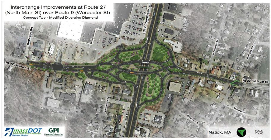
Tangential to the 95/128 conversation, but apropos nonetheless, MassDOT is proposing a modified diverging diamond as a replacement for the existing Rt. 9/Rt. 27 cloverleaf:


E2zvxGmXEAYHFTt
 
I wish that pedestrian infrastructure was more pedestrian/cyclist infrastructure and had easier access on the approaches for road cyclists. Route 27 is a major cycling route from Sherborn to Maynard.
 
Diverging diamond interchanges are like HAWK signals: MA drivers are going to need to get over their fear of the new.

I look at the illustration and think it will be a shame that all those trees will never grow up and mask the traffic hell that the area is.
 
Diverging diamond interchanges are like HAWK signals: MA drivers are going to need to get over their fear of the new.
I agree. I mean, build-to-suit to the environment of course; DD's aren't a fit for every situation. But if we're rendering our garments about how ped/cycle friendly-or-unfriendly they are, can we not gloss over the fact that Masshole cloverleafs are about the most terrorscape-unfriendly starting point imaginable? Like...I get the tendency for target fixation, but point-of-origin kind of also matters a real freaking lot. "What's a sidewalk?" is our starting point here. The amount of tarting-up that has to be done to make something in the realm of an upgrade to the existing cloverleaf design not be extremely unsafe is an enormous hurdle here. If some competing design truly has LOS superiority with equanimity to cars, peds, and bikes...by all means show it. But "fear of the mythical other" can't drive the process. We know Mass cloverleafs are a killzone for other road users, and this particular one is particularly terrible as Mass cloverleafs go. Something other than a cloverleaf needs to replace this one.
 
I wish that pedestrian infrastructure was more pedestrian/cyclist infrastructure and had easier access on the approaches for road cyclists. Route 27 is a major cycling route from Sherborn to Maynard.

It's hard to tell from the resolution of this image, but it seems like the wide paths are intended for actual bi-directional ped/cyclist use? (Lower side of MA-27 + right side of Route 9). They don't look too terrible to me. I guess that you're going to cross a road a bunch of times, but given that they're one-way roads with signalized traffic and (presumably) signals at the crossings, that's not awful?

And it looks like it establishes an actual usable path along 9 with a ped/cyclist interchange of sorts between 9/27 off the road.
 

Back
Top