
BostonUrbEx
Senior Member
- Joined
- Mar 13, 2010
- Messages
- 4,340
- Reaction score
- 127
As someone who hates BRT, I believe the Saugus Branch is one case where BRT would work. Light rail could serve the Saugus Branch effectively too, however street running is looked down upon by the MBTA and is more restrictive when dealing with mixed traffic. I believe buses would handle the load fine and don't forget: the ROW will be preserved in better condition this way if rail comes into play in the future.
Here's the map: http://www.google.com/maps/ms?ie=UT...14107067401485.00049fbacd8d0e6ec8770&t=h&z=13
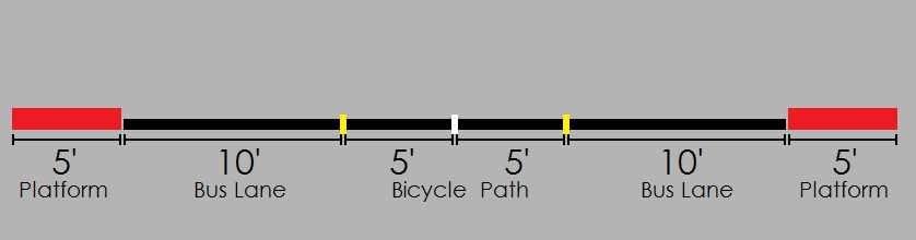
Phase I as a whole includes a brief run in mixed traffic from Malden Station's busways, down Centre St/Rt 60, and then peals off the road immediately upon reaching the Saugus Branch ROW. A fully paved busway with bike lanes in the center will now form nearly all of the rest of the BRT route. "Stations" (bus icon on map) will come with complete shelters (not *too* fancy, though!) and raised platforms which come up to the height of the bus floor. "Stops" (plain blue point icon) will be a very simple and basic platform as I'd expect these stops to have the lowest ridership.
Across Salem St from the former Rowes Quarry is a potential location for a Park & Ride collector for Rt 1 (and will also be convenient for the large apartment buildings going in the former quarry). It could be kept on a small scale as we can only do so much with capacity here and we don't want to cram the inbound buses before they even pass through Malden.
At the Salem St crossing on the Rever/Saugus line, half of the buses will head for Cliftondale Sq in Saugus in mixed traffic for about 3000 feet before looping around the Cliftondale Sq rotary. I'm unsure of where exactly the stop for Cliftondale Sq would be placed. As for the rest of the buses, they would proceed along the former Saugus Branch past Salem St and continue on up through the curve around present day Belmonte Middle School. It hits up Central St which will be the placement for the Saugus Center Station and the end of the line for Phase I, and buses will loop on a loop to the east on the ROW.
Phase II will hinge upon success of Phase I and/or Blue Line extension to Lynn. The BRT busway would continue along the Saugus Branch ROW until Lynn Common where it will once again run in mixed traffic making it's way to the Lynn Station busway and then making it's way back to the Saugus Branch ROW again.
ALL intersections with the dedicated busway will give buses priority/on demand signals. For the most part, stations will be located at street crossing, where platforms will be located before buses cross the street. This way, as soon as the bus stops, the cycle for priority will begin or the cycle can wait until some sort of on-demand system is initiated. However, it may vary by situation such as Linden Square where both platforms will be between two roads. Automatic cycles when buses stop are good for moderately used stations, and on-demand for stations with high use as they will likely need more time to stop and will not be immediately heading forward. Low traffic stops will automatically begin cycling before the bus even stops (if it does). Low volume roads (Denver St, Saugus and a couple streets around Railroad Ave, Malden may be the only cases) will place stop signs for all cars at all times and allow buses to continue without evening stopping.
Comments, questions, and suggestions are all welcome here. I think I really like this idea, very much! I feel like I should find a way to make this an official proposal somehow. Some may say the ridership would be low (at least in Saugus), but I would have to say it would be welcomed really well, and much more than rail, too. This could also be used to reroute existing bus routes off of streets or even eliminate some buses which would then be rendered significantly inferior and redundant. I believe Saugus would actually be a greatly improved town, perhaps becoming a bid of a minor TOD area, a bit more denser, and much more lively.
Here's the map: http://www.google.com/maps/ms?ie=UT...14107067401485.00049fbacd8d0e6ec8770&t=h&z=13
Phase I as a whole includes a brief run in mixed traffic from Malden Station's busways, down Centre St/Rt 60, and then peals off the road immediately upon reaching the Saugus Branch ROW. A fully paved busway with bike lanes in the center will now form nearly all of the rest of the BRT route. "Stations" (bus icon on map) will come with complete shelters (not *too* fancy, though!) and raised platforms which come up to the height of the bus floor. "Stops" (plain blue point icon) will be a very simple and basic platform as I'd expect these stops to have the lowest ridership.
Across Salem St from the former Rowes Quarry is a potential location for a Park & Ride collector for Rt 1 (and will also be convenient for the large apartment buildings going in the former quarry). It could be kept on a small scale as we can only do so much with capacity here and we don't want to cram the inbound buses before they even pass through Malden.
At the Salem St crossing on the Rever/Saugus line, half of the buses will head for Cliftondale Sq in Saugus in mixed traffic for about 3000 feet before looping around the Cliftondale Sq rotary. I'm unsure of where exactly the stop for Cliftondale Sq would be placed. As for the rest of the buses, they would proceed along the former Saugus Branch past Salem St and continue on up through the curve around present day Belmonte Middle School. It hits up Central St which will be the placement for the Saugus Center Station and the end of the line for Phase I, and buses will loop on a loop to the east on the ROW.
Phase II will hinge upon success of Phase I and/or Blue Line extension to Lynn. The BRT busway would continue along the Saugus Branch ROW until Lynn Common where it will once again run in mixed traffic making it's way to the Lynn Station busway and then making it's way back to the Saugus Branch ROW again.
ALL intersections with the dedicated busway will give buses priority/on demand signals. For the most part, stations will be located at street crossing, where platforms will be located before buses cross the street. This way, as soon as the bus stops, the cycle for priority will begin or the cycle can wait until some sort of on-demand system is initiated. However, it may vary by situation such as Linden Square where both platforms will be between two roads. Automatic cycles when buses stop are good for moderately used stations, and on-demand for stations with high use as they will likely need more time to stop and will not be immediately heading forward. Low traffic stops will automatically begin cycling before the bus even stops (if it does). Low volume roads (Denver St, Saugus and a couple streets around Railroad Ave, Malden may be the only cases) will place stop signs for all cars at all times and allow buses to continue without evening stopping.
Comments, questions, and suggestions are all welcome here. I think I really like this idea, very much! I feel like I should find a way to make this an official proposal somehow. Some may say the ridership would be low (at least in Saugus), but I would have to say it would be welcomed really well, and much more than rail, too. This could also be used to reroute existing bus routes off of streets or even eliminate some buses which would then be rendered significantly inferior and redundant. I believe Saugus would actually be a greatly improved town, perhaps becoming a bid of a minor TOD area, a bit more denser, and much more lively.
